
Laguna Canyon
Encyclopedia
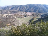
Laguna Canyon is a canyon, formerly a water gap
, that cuts through the San Joaquin Hills
in southern Orange County
in the U.S. state of California
, directly west of the city of Irvine
. The canyon runs steeply northeast-southwest, drained on the east side by San Diego Creek
and on the west by Laguna Canyon Creek. Starting as a wide and shallow valley, it narrows to a steep gorge as it nears Laguna Beach. California State Route 133
runs the entire length of the canyon connecting Laguna Beach and Irvine, while California State Route 73
crosses it, running southeast-northwest. A majority of the canyon is located within the Laguna Coast Wilderness; small portions are part of Aliso and Wood Canyons Regional Park and the cities of Irvine, Laguna Beach, Laguna Woods
and Aliso Viejo
.
and Aliso Viejo
to the east, the undeveloped San Joaquin Hills to the west, and Laguna Beach to the south. The drainage divide of the canyon is located near its northern end, separating Laguna Canyon from the San Diego Creek
watershed.
California State Route 133
, alternatively called the Laguna Canyon Road, winds through Laguna Canyon for the entire length of the gorge. California State Route 73
bisects the gorge east-west. The lower section of the canyon is contained in the Laguna Coast Wilderness, while the upper section is contained in a few smaller wilderness preserves. Some of the lower section has development, but the upper section remains relatively undeveloped. The northernmost extreme of the canyon lies near a residential area that adjoins Interstate 405
.
The canyon was most likely formed by San Diego Creek cutting through the rising San Joaquin Hills over a span of about 1.22 million years. At some point, however, the creek changed course, and the water gap it had formed was walled off by the mountains and became a separate watershed. The gradient of the drainage divide separating Laguna Canyon and the San Diego Creek watershed is, however, very small.
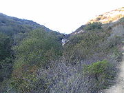 Laguna Canyon Creek begins as a ephemeral canyon that drops from a mountainside west of the valley floor down into the canyon. It crosses under California State Route 133 and enters a series of box culverts before spilling into a tree-lined channel. It soon passes the Laguna Lakes and receives Little Sycamore Canyon from the right; this creek drains a narrow side canyon which runs about 2 miles (3.2 km) eastward. The creek continues southward, and then passes beneath the road again and receives Camarillo Canyon, a short and steep tributary, from the right.
 The stream then runs south under the twin California State Route 73
bridges and enters an underground culvert beneath an onramp. While in this culvert, Laurel Canyon (which harbors a 100 feet (30.5 m) waterfall) and larger Willow Canyon join from the right, then about 0.5 mile (0.80467 km) later, the creek re-emerges from underground and flows in a riprap
lined channel for the next few miles. It receives its major tributary, El Toro Creek, from the left. El Toro Creek, which follows El Toro Road for much of its length, drains parts of Laguna Hills and Aliso Viejo before emptying into Laguna Canyon Creek.
The creek turns sharply west and then back south, then shortly after, is forced into a concrete-lined box culvert that carries it through downtown Laguna Beach. (This stretch is also known as Broadway Creek.) It then is diverted completely underground and its channel winds to an outfall at Main Beach, one of the most popular beaches in Laguna Beach.
s, and other structures. The debris basins, sometimes called retention basins, are circular depressions constructed by the Orange County Flood Control Division to slow down flash flood
s. The upper Laguna Canyon area has a few flood control channels and the lower creek is encased entirely in one; this begins as a riprap
channel with an unlined bottom, which transitions to a concrete culvert.
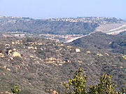
There are few developments within the main canyon, although the El Toro Creek area is primarily residential. There is also some commercial development downstream of State Route 73. Notably, where the creek passes through Laguna Beach, the concrete channel is undersized for the creek's peak flow, which caused it to overflow in the late 1990s.
s and coyote
s. Like Aliso and Wood Canyons Regional Park to the south, the canyon supports over one hundred species of birds. Some of its endangered species include California Gnatcatcher
, Cactus Wren
, and Orange-throated whiptail
. Except for the Laguna Lakes, the canyon has no fish habitat, and riparian habitat is at a minimal because of extensive modifications to the canyon's waterways and the ephemeral nature of the creeks.
, which is the dominant vegetation cover, typically goes through approximately 25-year cycles, with its peak biodiversity reached in roughly 10 years after the beginning of a new 25-year period. Such periods are typically separated by wildfire
s, which clear away dead or dying vegetation and leave bare ground for new growth. Another 40 or so plant species constitute the primary vegetation cover in the watershed. The canyon is one of the last remaining sanctuaries for many plants native to Southern California. Although chaparral is the primary vegetation, the canyon also has a wide variety of other plants; approximately one hundred species of plants, most native to California, are found in Laurel and Willow Canyons alone. These include monkey flower, goldenrod
, and sagebrush
.
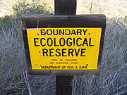
Laguna Canyon forms the center section of an approximately 17500 acres (70.8 km²) strip of wilderness preserve running northeast-southwest along the Pacific coast
. Most of the canyon is covered by Laguna Coast Wilderness, which extends over 6500 acres (26.3 km²). It is bordered on the south by Aliso and Wood Canyons Regional Park, and on its north by Crystal Cove State Park
. The parks are managed by the County of Orange and the California Department of Fish and Game
, while portions of Laguna Coast are also owned by the City of Laguna Beach. Although there is no trail that follows the main canyon (as it is traversed by State Route 133), there are many trails, mostly hiking, that lead up narrow side canyons, as well as a trail that circumnavigates Laguna Lakes. Several connecting trails run east-south towards Aliso and Wood Canyons, providing access between the two watersheds.
, the Laguna Canyon area lay within the tribal boundary of the Tongva, a Native American group whose territory expanded from north-central Orange County well past the San Gabriel River
and into the Los Angeles Basin
. Aliso Creek, whose watershed borders Laguna Canyon to the east, formed the tribal boundary between the Tongva and Acjachemen.
Laguna Canyon Creek was a seasonal stream but the Laguna Lakes, formed by springs arising from a minor fault zone, stayed year round. A Native American path ran through the canyon to the present-day Laguna Beach area, where they collected abalone
and limpet
s, and fished. The Tongva lived in villages of 50-100 members, in huts made of brushes and tules on a wooden framework. When the Spanish conquistador
s arrived in the mid-18th century, they named the canyon "Cañada de las Lagunas", referring to the Laguna Lakes. A land grant
, called La Bolsa de San Joaquín, occupied the canyon area up to the 19th century. By 1905, springs in the Laguna Canyon area began to supply water to Laguna Beach.
 Before Laguna Canyon became a wilderness park, a housing development was proposed to be built in and around the canyon, tentatively called "Laguna Laurel". The 2150 acres (8.7 km²) community, which was proposed to contain 3,200 housing units as well as a number of businesses, was canceled in the 1990s after the City of Laguna Beach purchased four of its parcels in order to provide space for a wilderness park, while the City of Irvine purchased one, and Laguna Coast Wilderness Park was opened and dedicated in 1993. Occasionally, the park system (which adjoins Aliso/Wood Canyons Regional Park
) is augmented by donations of vacant land. The proposal to stop the development was supported by a crowd of eight thousand in 1989, which gathered in Laguna Canyon in a protest known as the "Walk-In". Several years later, two to three thousand gathered to protest the construction of California State Route 73
(which would cross the canyon), but the highway was built eventually.
In 1993, a massive wildfire
burned over 16000 acres (64.7 km²) in Laguna Canyon and Laguna Beach, and ranked behind the 1948 Santa Ana Canyon fire as one of the worst fires in Orange County history. The fire was in part caused by strong Santa Ana Winds, which caused flames that rose up to 200 feet (61 m) high.
s in the northern part of the canyon.
The entirety of the mainstem of Laguna Canyon has been impacted by development, mostly from construction of the state highway but also from buildings in the canyon in the last 3 miles (4.8 km). Most of the remaining wild lands are now found in the side canyons. These modifications have also resulted in bacterial pollution downstream at Main Beach, Laguna Beach. There now are several organizations working on preserving what remains of the canyon; Laguna Canyon Foundation is the most prominent one.
Water gap
A water gap is an opening or notch which flowing water has carved through a mountain range. Water gaps often offer a practical route for road and rail transport to cross mountain ridges.- Geology :...
, that cuts through the San Joaquin Hills
San Joaquin Hills
The San Joaquin Hills are a set of low hills in coastal Orange County, California. They extend in a northwest-southeast direction, starting in the northwest in Newport Beach at the southern edge of the Los Angeles Basin, and extending southeast to San Juan Capistrano.-Geography and habitats:Named...
in southern Orange County
Orange County, California
Orange County is a county in the U.S. state of California. Its county seat is Santa Ana. As of the 2010 census, its population was 3,010,232, up from 2,846,293 at the 2000 census, making it the third most populous county in California, behind Los Angeles County and San Diego County...
in the U.S. state of California
California
California is a state located on the West Coast of the United States. It is by far the most populous U.S. state, and the third-largest by land area...
, directly west of the city of Irvine
Irvine, California
Irvine is a suburban incorporated city in Orange County, California, United States. It is a planned city, mainly developed by the Irvine Company since the 1960s. Formally incorporated on December 28, 1971, the city has a population of 212,375 as of the 2010 census. However, the California...
. The canyon runs steeply northeast-southwest, drained on the east side by San Diego Creek
San Diego Creek
San Diego Creek is a waterway flowing into Upper Newport Bay in central Orange County in the U.S. state of California. Its basin covers in parts of eight cities, including Irvine, Tustin, and Costa Mesa. The major tributary of the northeast-flowing stream is Peters Canyon Wash, which joins a few...
and on the west by Laguna Canyon Creek. Starting as a wide and shallow valley, it narrows to a steep gorge as it nears Laguna Beach. California State Route 133
California State Route 133
State Route 133 is a state highway in the U.S. state of California. It connects SR 1 in Laguna Beach through the San Joaquin Hills with several freeways in Irvine, ending at the SR 241 toll road in the latter city...
runs the entire length of the canyon connecting Laguna Beach and Irvine, while California State Route 73
California State Route 73
State Route 73 is a state highway in the U.S. state of California. The route runs from Interstate 405 to Interstate 5 through the San Joaquin Hills in Orange County. From its northern terminus, the first three miles of the highway are called the Corona del Mar Freeway; this section of highway...
crosses it, running southeast-northwest. A majority of the canyon is located within the Laguna Coast Wilderness; small portions are part of Aliso and Wood Canyons Regional Park and the cities of Irvine, Laguna Beach, Laguna Woods
Laguna Woods, California
Laguna Woods is a city in Orange County, California, United States. The population was 16,192 at the 2010 census, down from 16,507 at the 2000 census with a median age of 78. About 90% of the city consists of Laguna Woods Village, a retirement community, formerly known as Leisure World...
and Aliso Viejo
Aliso Viejo, California
Aliso Viejo is a city in Orange County, California. It had a population of 47,823 as of the 2010 census, up from 40,166 as of the 2000 census. It became Orange County's 34th city on July 1, 2001, the only city in the county to incorporate since 2000...
.
Geography and geology
Laguna Canyon is a generally north-south running gorge approximately 8 miles (12.9 km) long and 1 miles (1.6 km) wide at the broadest points. The city of Irvine lies to the north, Lake ForestLake Forest, California
Lake Forest is a city in Orange County, California. The population was 77,264 at the 2010 census.Lake Forest incorporated as a city on December 20, 1991. Prior to a vote of the residents in that year, the community had formerly been known as El Toro since the 1880s...
and Aliso Viejo
Aliso Viejo, California
Aliso Viejo is a city in Orange County, California. It had a population of 47,823 as of the 2010 census, up from 40,166 as of the 2000 census. It became Orange County's 34th city on July 1, 2001, the only city in the county to incorporate since 2000...
to the east, the undeveloped San Joaquin Hills to the west, and Laguna Beach to the south. The drainage divide of the canyon is located near its northern end, separating Laguna Canyon from the San Diego Creek
San Diego Creek
San Diego Creek is a waterway flowing into Upper Newport Bay in central Orange County in the U.S. state of California. Its basin covers in parts of eight cities, including Irvine, Tustin, and Costa Mesa. The major tributary of the northeast-flowing stream is Peters Canyon Wash, which joins a few...
watershed.
California State Route 133
California State Route 133
State Route 133 is a state highway in the U.S. state of California. It connects SR 1 in Laguna Beach through the San Joaquin Hills with several freeways in Irvine, ending at the SR 241 toll road in the latter city...
, alternatively called the Laguna Canyon Road, winds through Laguna Canyon for the entire length of the gorge. California State Route 73
California State Route 73
State Route 73 is a state highway in the U.S. state of California. The route runs from Interstate 405 to Interstate 5 through the San Joaquin Hills in Orange County. From its northern terminus, the first three miles of the highway are called the Corona del Mar Freeway; this section of highway...
bisects the gorge east-west. The lower section of the canyon is contained in the Laguna Coast Wilderness, while the upper section is contained in a few smaller wilderness preserves. Some of the lower section has development, but the upper section remains relatively undeveloped. The northernmost extreme of the canyon lies near a residential area that adjoins Interstate 405
Interstate 405
Interstate 405 may refer to:* Interstate 405 , a bypass of Los Angeles, California* Interstate 405 , a loop in Portland, Oregon* Interstate 405 , a bypass of Seattle, Washington...
.
The canyon was most likely formed by San Diego Creek cutting through the rising San Joaquin Hills over a span of about 1.22 million years. At some point, however, the creek changed course, and the water gap it had formed was walled off by the mountains and became a separate watershed. The gradient of the drainage divide separating Laguna Canyon and the San Diego Creek watershed is, however, very small.
The creek
California State Route 73
State Route 73 is a state highway in the U.S. state of California. The route runs from Interstate 405 to Interstate 5 through the San Joaquin Hills in Orange County. From its northern terminus, the first three miles of the highway are called the Corona del Mar Freeway; this section of highway...
bridges and enters an underground culvert beneath an onramp. While in this culvert, Laurel Canyon (which harbors a 100 feet (30.5 m) waterfall) and larger Willow Canyon join from the right, then about 0.5 mile (0.80467 km) later, the creek re-emerges from underground and flows in a riprap
Riprap
Riprap — also known as rip rap, rubble, shot rock or rock armour or "Rip-rap" — is rock or other material used to armor shorelines, streambeds, bridge abutments, pilings and other shoreline structures against scour, water or ice erosion.It is made from a variety of rock types, commonly granite or...
lined channel for the next few miles. It receives its major tributary, El Toro Creek, from the left. El Toro Creek, which follows El Toro Road for much of its length, drains parts of Laguna Hills and Aliso Viejo before emptying into Laguna Canyon Creek.
The creek turns sharply west and then back south, then shortly after, is forced into a concrete-lined box culvert that carries it through downtown Laguna Beach. (This stretch is also known as Broadway Creek.) It then is diverted completely underground and its channel winds to an outfall at Main Beach, one of the most popular beaches in Laguna Beach.
Modifications
Laguna Canyon and its side tributaries have received some man-made flood control modifications. These include debris basins at the mouth of nearly every major tributary, stretches of lined or unlined flood control channelFlood control channel
Flood control channels are a series of large and empty open-air channels that extend a ways below the street levels of some larger cities, so that if and when a flood occurs, the flood will run into the channels, and proceed to be drained to the proper body of water...
s, and other structures. The debris basins, sometimes called retention basins, are circular depressions constructed by the Orange County Flood Control Division to slow down flash flood
Flash flood
A flash flood is a rapid flooding of geomorphic low-lying areas—washes, rivers, dry lakes and basins. It may be caused by heavy rain associated with a storm, hurricane, or tropical storm or meltwater from ice or snow flowing over ice sheets or snowfields...
s. The upper Laguna Canyon area has a few flood control channels and the lower creek is encased entirely in one; this begins as a riprap
Riprap
Riprap — also known as rip rap, rubble, shot rock or rock armour or "Rip-rap" — is rock or other material used to armor shorelines, streambeds, bridge abutments, pilings and other shoreline structures against scour, water or ice erosion.It is made from a variety of rock types, commonly granite or...
channel with an unlined bottom, which transitions to a concrete culvert.
There are few developments within the main canyon, although the El Toro Creek area is primarily residential. There is also some commercial development downstream of State Route 73. Notably, where the creek passes through Laguna Beach, the concrete channel is undersized for the creek's peak flow, which caused it to overflow in the late 1990s.
Animals
The Laguna Canyon area supports mostly native Southern California wildlife, including large mammals such as mountain lions, bobcatBobcat
The bobcat is a North American mammal of the cat family Felidae, appearing during the Irvingtonian stage of around 1.8 million years ago . With twelve recognized subspecies, it ranges from southern Canada to northern Mexico, including most of the continental United States...
s and coyote
Coyote
The coyote , also known as the American jackal or the prairie wolf, is a species of canine found throughout North and Central America, ranging from Panama in the south, north through Mexico, the United States and Canada...
s. Like Aliso and Wood Canyons Regional Park to the south, the canyon supports over one hundred species of birds. Some of its endangered species include California Gnatcatcher
California Gnatcatcher
The California Gnatcatcher, Polioptila californica, is a small 10.8 cm long insectivorous bird which frequents dense coastal sage scrub growth...
, Cactus Wren
Cactus Wren
The Cactus Wren is a species of wren that is native to the southwestern United States southwards to central Mexico.-Description:...
, and Orange-throated whiptail
Orange-throated whiptail
The Orange-throated whiptail is a species of lizard in the family Teiidae. It was previously placed in the genus Cnemidophorus. A. hyperythra has five or six light colored stripes down a black, brown, or grey dorsal side. The middle stripe may be forked at both ends...
. Except for the Laguna Lakes, the canyon has no fish habitat, and riparian habitat is at a minimal because of extensive modifications to the canyon's waterways and the ephemeral nature of the creeks.
Plants
In the canyon, chaparralChaparral
Chaparral is a shrubland or heathland plant community found primarily in the U.S. state of California and in the northern portion of the Baja California peninsula, Mexico...
, which is the dominant vegetation cover, typically goes through approximately 25-year cycles, with its peak biodiversity reached in roughly 10 years after the beginning of a new 25-year period. Such periods are typically separated by wildfire
Wildfire
A wildfire is any uncontrolled fire in combustible vegetation that occurs in the countryside or a wilderness area. Other names such as brush fire, bushfire, forest fire, desert fire, grass fire, hill fire, squirrel fire, vegetation fire, veldfire, and wilkjjofire may be used to describe the same...
s, which clear away dead or dying vegetation and leave bare ground for new growth. Another 40 or so plant species constitute the primary vegetation cover in the watershed. The canyon is one of the last remaining sanctuaries for many plants native to Southern California. Although chaparral is the primary vegetation, the canyon also has a wide variety of other plants; approximately one hundred species of plants, most native to California, are found in Laurel and Willow Canyons alone. These include monkey flower, goldenrod
Goldenrod
Solidago, commonly called goldenrods, is a genus of about 100 species of flowering plants in the family Asteraceae. Most are herbaceous perennial species found in the meadows and pastures, along roads, ditches and waste areas in North America. There are also a few species native to Mexico, South...
, and sagebrush
Sagebrush
Sagebrush is a common name of a number of shrubby plant species in the genus Artemisia native to western North America;Or, the sagebrush steppe ecoregion, having one or more kinds of sagebrush, bunchgrasses and others;...
.
Recreation
Laguna Canyon forms the center section of an approximately 17500 acres (70.8 km²) strip of wilderness preserve running northeast-southwest along the Pacific coast
Pacific Coast
A country's Pacific coast is the part of its coast bordering the Pacific Ocean.-The Americas:Countries on the western side of the Americas have a Pacific coast as their western border.* Geography of Canada* Geography of Chile* Geography of Colombia...
. Most of the canyon is covered by Laguna Coast Wilderness, which extends over 6500 acres (26.3 km²). It is bordered on the south by Aliso and Wood Canyons Regional Park, and on its north by Crystal Cove State Park
Crystal Cove State Park
Crystal Cove State Park is a state park of California, USA, encompassing of Pacific coastline, inland chaparral canyons, and the Crystal Cove Historic District of beach houses. The park located in Newport Beach. Crystal Cove is a stretch of coastal cliffs and a beachfront cove situated between...
. The parks are managed by the County of Orange and the California Department of Fish and Game
California Department of Fish and Game
The California Department of Fish and Game is a department within the government of California, falling under its parent California Natural Resources Agency. The Department of Fish and Game manages and protects the state's diverse fish, wildlife, plant resources, and native habitats...
, while portions of Laguna Coast are also owned by the City of Laguna Beach. Although there is no trail that follows the main canyon (as it is traversed by State Route 133), there are many trails, mostly hiking, that lead up narrow side canyons, as well as a trail that circumnavigates Laguna Lakes. Several connecting trails run east-south towards Aliso and Wood Canyons, providing access between the two watersheds.
History
Lying to the north of Aliso CanyonAliso Canyon
Aliso Canyon is a canyon cut through the San Joaquin Hills by Aliso Creek. Located in Orange County in the U.S. state of California, the canyon's name derives from the Spanish word for alder....
, the Laguna Canyon area lay within the tribal boundary of the Tongva, a Native American group whose territory expanded from north-central Orange County well past the San Gabriel River
San Gabriel River (California)
The San Gabriel River flows through southern Los Angeles County, California in the United States. Its main stem is about long, while its farthest tributaries extend almost altogether...
and into the Los Angeles Basin
Los Angeles Basin
The Los Angeles Basin is the coastal sediment-filled plain located between the Peninsular and Transverse ranges in southern California in the United States containing the central part of the city of Los Angeles as well as its southern and southeastern suburbs...
. Aliso Creek, whose watershed borders Laguna Canyon to the east, formed the tribal boundary between the Tongva and Acjachemen.
Laguna Canyon Creek was a seasonal stream but the Laguna Lakes, formed by springs arising from a minor fault zone, stayed year round. A Native American path ran through the canyon to the present-day Laguna Beach area, where they collected abalone
Abalone
Abalone , from aulón, are small to very large-sized edible sea snails, marine gastropod molluscs in the family Haliotidae and the genus Haliotis...
and limpet
Limpet
Limpet is a common name for a number of different kinds of saltwater and freshwater snails ; it is applied to those snails that have a simple shell which is more or less conical in shape, and either is not spirally coiled, or appears not to be coiled in the adult snails.The name limpet is most...
s, and fished. The Tongva lived in villages of 50-100 members, in huts made of brushes and tules on a wooden framework. When the Spanish conquistador
Conquistador
Conquistadors were Spanish soldiers, explorers, and adventurers who brought much of the Americas under the control of Spain in the 15th to 16th centuries, following Europe's discovery of the New World by Christopher Columbus in 1492...
s arrived in the mid-18th century, they named the canyon "Cañada de las Lagunas", referring to the Laguna Lakes. A land grant
Ranchos of California
The Spanish, and later the Méxican government encouraged settlement of territory now known as California by the establishment of large land grants called ranchos, from which the English ranch is derived. Devoted to raising cattle and sheep, the owners of the ranchos attempted to pattern themselves...
, called La Bolsa de San Joaquín, occupied the canyon area up to the 19th century. By 1905, springs in the Laguna Canyon area began to supply water to Laguna Beach.
Aliso/Wood Canyons Regional Park
Aliso and Wood Canyons Regional Park is a major regional park and wildlife sanctuary in Orange County in the U.S. state of California, covering approximately 3,879 acres in the lower watershed of Aliso Creek. It borders the suburban districts of Aliso Viejo, Dana Point, and Laguna Niguel, and...
) is augmented by donations of vacant land. The proposal to stop the development was supported by a crowd of eight thousand in 1989, which gathered in Laguna Canyon in a protest known as the "Walk-In". Several years later, two to three thousand gathered to protest the construction of California State Route 73
California State Route 73
State Route 73 is a state highway in the U.S. state of California. The route runs from Interstate 405 to Interstate 5 through the San Joaquin Hills in Orange County. From its northern terminus, the first three miles of the highway are called the Corona del Mar Freeway; this section of highway...
(which would cross the canyon), but the highway was built eventually.
In 1993, a massive wildfire
Wildfire
A wildfire is any uncontrolled fire in combustible vegetation that occurs in the countryside or a wilderness area. Other names such as brush fire, bushfire, forest fire, desert fire, grass fire, hill fire, squirrel fire, vegetation fire, veldfire, and wilkjjofire may be used to describe the same...
burned over 16000 acres (64.7 km²) in Laguna Canyon and Laguna Beach, and ranked behind the 1948 Santa Ana Canyon fire as one of the worst fires in Orange County history. The fire was in part caused by strong Santa Ana Winds, which caused flames that rose up to 200 feet (61 m) high.
Future
The canyon is one of the last remaining wild areas in Orange County in a strip of preserves along the San Joaquin Hills about 20 miles (32.2 km) long and 8 miles (12.9 km) wide. Recently, State Route 133 has been expanded to four lanes from the original two lanes; the original road is now a one-way southbound. The newly constructed road is mostly parallel to the original road but is closer to Laguna Canyon Creek. Recent construction work at the head of Laguna Canyon near the city of Irvine has leveled some hills on the east side of the canyon, but construction has presently stopped. There are plans to turn the northernmost extreme of the Canyon into a residential development consisting of 590 houses, called Laguna Crossing. It was originally planned to open in 2008 but this date has been moved to 2013. There also has been work on culvertCulvert
A culvert is a device used to channel water. It may be used to allow water to pass underneath a road, railway, or embankment. Culverts can be made of many different materials; steel, polyvinyl chloride and concrete are the most common...
s in the northern part of the canyon.
The entirety of the mainstem of Laguna Canyon has been impacted by development, mostly from construction of the state highway but also from buildings in the canyon in the last 3 miles (4.8 km). Most of the remaining wild lands are now found in the side canyons. These modifications have also resulted in bacterial pollution downstream at Main Beach, Laguna Beach. There now are several organizations working on preserving what remains of the canyon; Laguna Canyon Foundation is the most prominent one.
See also
- Biology of Aliso and Wood Canyons Regional Park
- Wildlife of Aliso Creek