

Fresno River
Encyclopedia
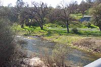
River
A river is a natural watercourse, usually freshwater, flowing towards an ocean, a lake, a sea, or another river. In a few cases, a river simply flows into the ground or dries up completely before reaching another body of water. Small rivers may also be called by several other names, including...
in Central California
Central California
Central California, sometimes referenced as Mid-State, is an area of California south of the San Francisco Bay Area and north of Southern California...
and a major tributary of the San Joaquin River
San Joaquin River
The San Joaquin River is the largest river of Central California in the United States. At over long, the river starts in the high Sierra Nevada, and flows through a rich agricultural region known as the San Joaquin Valley before reaching Suisun Bay, San Francisco Bay, and the Pacific Ocean...
. It runs approximately 68 miles (109.4 km) from the Sierra Nevada Range to the San Joaquin River.
Course
The Fresno River is formed by the confluence of Nelder Creek and Lewis Fork near the locality of Yosemite ForksYosemite Forks, California
Yosemite Forks is an unincorporated community in Madera County, California. It is located northeast of Raymond, at an elevation of 2907 feet . The road forks at the place: one continues to Yosemite Valley, the other to Bass Lake....
. From this point, it flows south to Oakhurst
Oakhurst, California
Oakhurst is a census-designated place in Madera County, California, south of the entrance to Yosemite National Park, in the foothills of the Sierra Nevada mountain range. Oakhurst is located on the Fresno River south-southwest of Yosemite Forks, at an elevation of 2274 feet...
, west for several miles, then southwest to Hensley Lake. Below the lake, the river flows southwest to Madera
Madera, California
Madera is a city in and the county seat of Madera County, California, United States. It is a principal city of the Madera–Chowchilla Metropolitan Statistical Area, which encompasses all of Madera County, and Metropolitan Fresno. It is located in California's San Joaquin Valley. As of the 2010...
, then west to the Eastside Bypass. The river exits the bypass then flows generally northwest to its confluence with the San Joaquin River, just north of Highway 152
California State Route 152
State Route 152 is a state highway that runs near the latitudinal middle of the U.S. state of California from Watsonville to Route 99 southeast of Merced...
.
Lakes and dams
Hidden Dam is the only major storage dam on the Fresno River. The dam forms Hensley Lake, a 90000 acre.foot reservoir. The United States Army Corps of EngineersUnited States Army Corps of Engineers
The United States Army Corps of Engineers is a federal agency and a major Army command made up of some 38,000 civilian and military personnel, making it the world's largest public engineering, design and construction management agency...
built the earth-fill dam, which was completed in 1974. Its primary purpose is flood
Flood
A flood is an overflow of an expanse of water that submerges land. The EU Floods directive defines a flood as a temporary covering by water of land not normally covered by water...
control, but it is also used to regulate flows for irrigation
Irrigation
Irrigation may be defined as the science of artificial application of water to the land or soil. It is used to assist in the growing of agricultural crops, maintenance of landscapes, and revegetation of disturbed soils in dry areas and during periods of inadequate rainfall...
and groundwater
Groundwater
Groundwater is water located beneath the ground surface in soil pore spaces and in the fractures of rock formations. A unit of rock or an unconsolidated deposit is called an aquifer when it can yield a usable quantity of water. The depth at which soil pore spaces or fractures and voids in rock...
recharge. In 1978, the lake was opened to the public for recreation
Recreation
Recreation is an activity of leisure, leisure being discretionary time. The "need to do something for recreation" is an essential element of human biology and psychology. Recreational activities are often done for enjoyment, amusement, or pleasure and are considered to be "fun"...
and is a popular boating and fishing destination for locals.
Below Hidden Dam, the Fresno River provides water to Madera Lake via an unnamed distributary. Excess flow from the lake is returned to the Fresno River by the lake's dam. Further downstream, on the northeast edge of Madera, is the John Franchi Diversion Dam, a 15 feet (4.6 m) high, 263 feet (80.2 m)-wide earth and steel dam that is used to divert water into the Madera Canal
Madera Canal
The Madera Canal is a aqueduct in the U.S. state of California. It is part of the Central Valley Project managed by the United States Bureau of Reclamation to convey water north to augment irrigation capacity in Madera County, California. It was also the subject of the United States Supreme...
. The dam was built by the United States Bureau of Reclamation
United States Bureau of Reclamation
The United States Bureau of Reclamation , and formerly the United States Reclamation Service , is an agency under the U.S...
in 1964 and is operated by the Madera Irrigation District. From this point, the river is normally dry. The only time water is released past here is when water levels are high enough to spill over the dam.
Lower river

Madera County, California
Madera County is a county of the U.S. state of California, located in the Central Valley and the Sierra Nevada north of Fresno County. It comprises the Madera-Chowchilla, CA Metropolitan Statistical Area. As of the 2010 census the population was 150,865...
, the Fresno River's natural riverbed has been subject to much intervention by man and as a result, the natural riverbed has many gaps in it, which are now connected by man-made canals.
At Road 17, the natural riverbed has been modified to divert most flows into a manmade canal, which leads to the Eastside Bypass. Water can also be allowed to continue flowing down the main river channel (north of the man-made canal), but that water now ends up in the Bypass as well.
Once in the Bypass, water can exit via a small channel at a diversion dam and continue west along the natural riverbed the rest of the way to the San Joaquin River. Between the Eastside Bypass and the San Joaquin River, the riverbed (which is almost always dry) has been subject to straightening, but more or less follows its natural course.
Tributaries
In addition to many small unnamed streams, the Fresno River receives the water from the following streams:- China Creek
- Miami Creek
- Crooks Creek
- Spangle Gold Creek
- Willow Creek
- Mud Spring Creek
- China Slough
- South Fork Fresno River
- This is a distributary that branches off to form a small island, then returns to the mainline Fresno River.
- Berenda Slough
Towns
Towns along the Fresno River include:- OakhurstOakhurst, CaliforniaOakhurst is a census-designated place in Madera County, California, south of the entrance to Yosemite National Park, in the foothills of the Sierra Nevada mountain range. Oakhurst is located on the Fresno River south-southwest of Yosemite Forks, at an elevation of 2274 feet...
(Unincorporated) - MaderaMadera, CaliforniaMadera is a city in and the county seat of Madera County, California, United States. It is a principal city of the Madera–Chowchilla Metropolitan Statistical Area, which encompasses all of Madera County, and Metropolitan Fresno. It is located in California's San Joaquin Valley. As of the 2010...
Crossings
There are numerous crossings over the Fresno River in Madera and Merced Counties. Crossings are listed here beginning at the source and working downstream:- Madera County above Hensley Lake
- Crane Valley Road (Road 426)
- State Route 41California State Route 41State Route 41 is a state highway in the U.S. state of California, connecting the Cabrillo Highway in Morro Bay with Fresno and Yosemite National Park via the San Joaquin Valley. Except between US 101 in Atascadero and SR 46 near Shandon, SR 41 is part of the California Freeway and Expressway...
- River View Drive
- Dupfy Fire Road (Road 8084)
- Ellerbrock Station Road
- Raymond Road (Road 415)
- Madera County below Hensley Lake
- Daulton Road (Road 603)
- City of Madera
- East Cleveland Avenue
- North Lake Street
- North D Street
- North Gateway Drive
- State Route 99California State Route 99California State Route 99 , commonly known as Highway 99 or, simply, as 99 , is a north–south state highway in the U.S. state of California, stretching almost the entire length of the Central Valley...
- Schnoor Avenue
- North Granada Drive
- Westberry Boulevard
- Madera County below the City of Madera
- Road 23
- Road 20
- Road 19
- Road 16
- Road 9
- Road 1
- Merced County
- State Route 152California State Route 152State Route 152 is a state highway that runs near the latitudinal middle of the U.S. state of California from Watsonville to Route 99 southeast of Merced...
- State Route 152