

Bridalveil Creek
Encyclopedia
Yosemite National Park
Yosemite National Park is a United States National Park spanning eastern portions of Tuolumne, Mariposa and Madera counties in east central California, United States. The park covers an area of and reaches across the western slopes of the Sierra Nevada mountain chain...
along Glacier Point road, is a first-come first-served campground outside of Yosemite Valley
Yosemite Valley
Yosemite Valley is a glacial valley in Yosemite National Park in the western Sierra Nevada mountains of California, carved out by the Merced River. The valley is about long and up to a mile deep, surrounded by high granite summits such as Half Dome and El Capitan, and densely forested with pines...
. The campground is directly off the road and thus does not require a rough drive to the campground like other Yosemite campgrounds outside of the Valley (Yosemite Creek & Tamarack Flat are examples 2-4 mile unpaved roads leading into the campground off the main road). Bridalveil Creek Campground contains 110 campsites and is in the high-country at 7000 feet (2,133.6 m). It is fairly isolated and quiet. This campground is especially good considering its proximity to Glacier Point
Glacier Point
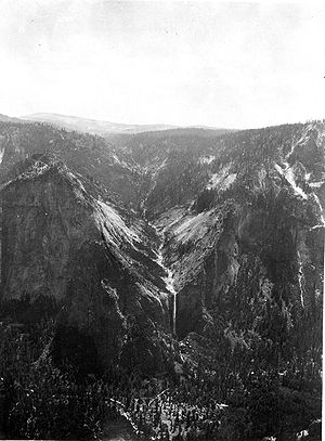
thumb|right|upright|Glacier Point, as seen from [[Yosemite Valley]]. In springtime, this cliff face is covered with dozens of freshets and tiny waterfalls from the snowmelt, the largest being [[Staircase Falls]]....
. Given the convenience one can more easily drive to Glacier Point
Glacier Point
thumb|right|upright|Glacier Point, as seen from [[Yosemite Valley]]. In springtime, this cliff face is covered with dozens of freshets and tiny waterfalls from the snowmelt, the largest being [[Staircase Falls]]....
at night to survey the night sky.
The Valley is quite far from Bridalveil Creek and those looking to venture into northern regions of Yosemite National Park should expect a long drive.
Destinations Nearby
- Ostrander LakeOstrander LakeOstrander Lake is located in Yosemite National Park, approximately south of Yosemite Valley and east of the Badger Pass Ski Area, at an elevation of . The lake is a popular destination for cross-country skiers during the winter...
Trailhead (8 Min) - Taft PointTaft PointTaft Point, located in Yosemite National Park near Glacier Point is very much like Glacier Point in that it offers wide views of the valley and other attractions like Yosemite Falls and El Capitan. However, the main attraction of Taft Point are the giant fissures in the mile high granite rock...
/Sentinel DomeSentinel DomeSentinel Dome is a granite dome in Yosemite National Park, United States. It lies on the south wall of Yosemite Valley, southwest of Glacier Point and northeast of Profile Cliff....
Trailhead (14 min) - Glacier PointGlacier Pointthumb|right|upright|Glacier Point, as seen from [[Yosemite Valley]]. In springtime, this cliff face is covered with dozens of freshets and tiny waterfalls from the snowmelt, the largest being [[Staircase Falls]]....
(18 Min) - Yosemite ValleyYosemite ValleyYosemite Valley is a glacial valley in Yosemite National Park in the western Sierra Nevada mountains of California, carved out by the Merced River. The valley is about long and up to a mile deep, surrounded by high granite summits such as Half Dome and El Capitan, and densely forested with pines...
(35 Min)