

Redwood Creek (Humboldt County)
Encyclopedia
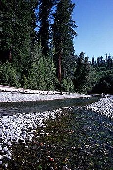
Redwood Creek is a 61.8 miles (99.5 km) river in Humboldt County, California
. The river's headwaters are in the Coast Range at about 5000 feet (1,524 m) and it flows roughly northwest until it empties into the Pacific Ocean
near the small town of Orick
, the only development in the 280 square miles (725.2 km²)-watershed
.
. The stream's headwaters lie at about 4400 feet (1,341.1 m) above sea level, in a network of small unnamed streams along the north sides of a ridge abutting the Mad River
valley to the south. It flows north through a deep forested valley, receiving many small tributaries including Minor and Lacks creeks from the right. About 15 miles (24.1 km) downstream of the source, the creek crosses under State Route 299
.
Slightly less than 20 miles (32.2 km) from the mouth, the river passes the southern boundary of Redwood National Park. It then receives Bridge Creek from the left, before winding through several groves of Sequoia sempervirens, more commonly known as redwood trees, from which the stream takes its name. Several of the tallest redwoods in the world are near the creeks banks. Near the small town of Orick
it curves west, and receives Prairie Creek, its largest tributary, from the right. It empties into the Pacific Ocean about 30 miles (48.3 km) north of Eureka
and 27 miles (43.5 km) south of Crescent City
.
encompasses 280 mi2 on the western slopes of the California Coast Ranges, entirely within Humboldt County. It stretches about 56 kilometres (34.8 mi) from north to south and ranges from 4.5 to 7 mi (7.2 to 11.3 km) wide. Most of the stream flows in a broad, 1500 feet (457.2 m)-deep valley sandwiched between the Mad River
basin to the west, and the Klamath River
drainage to the east. Elevations range from over 5000 feet (1,524 m) on higher peaks of the mountains near the headwaters to sea level at the creek's mouth at the Pacific. The small town of Orick and the narrow strip of surrounding farmland are the only significant development in the entire basin. The river is free flowing and has no dams, only a few agricultural diversions in the last 3 miles (4.8 km) above the mouth.
are in Redwood National and State Parks
, but the upper portion is mostly privately owned. The park makes up 41 percent of the watershed and the Bureau of Land Management
and United States Forest Service
own 3 percent. Private lands downstream of the parks makes up only 1 percent. Private lands upstream make up 55 percent, 90 percent of which is owned by eight landowners, Simpson Timber Company being the largest.
 The greatest problem for the creek and its tributaries is erosion
, which leads to excessive sediment
buildup in the streambeds. The increased erosion is caused by extensive logging
in the upper watershed, which began in the 1950s and continues today as the primary land use. In the last couple of decades alone, 65 % of all land and 75 % of the forest
ed land in the basin has been harvested for timber
. The building of logging roads has also increased erosion in the watershed. The sediment has filled in the pools and spawning habitat used by steelhead
and coho salmon
, which has caused a major decline in the fishery
.
Habitat in the lower portion of the creek has been degraded due to actions taken after the flood
ing of 1955 and 1964. The United States Army Corps of Engineers
channelized the last 3.4 miles (5.5 km) of the creek through dredging and the building of levee
s. This has changed the creek's hydrology and sedimentation patterns, resulting in a decrease in flow. In addition, it has destroyed the riparian vegetation, which helps protect against erosion and decreases the water temperature to a level suitable for the creek's coldwater fish
.
Humboldt County, California
Humboldt County is a county in the U.S. state of California, located on the far North Coast 200 miles north of San Francisco. According to 2010 Census Data, the county’s population was 134,623...
. The river's headwaters are in the Coast Range at about 5000 feet (1,524 m) and it flows roughly northwest until it empties into the Pacific Ocean
Pacific Ocean
The Pacific Ocean is the largest of the Earth's oceanic divisions. It extends from the Arctic in the north to the Southern Ocean in the south, bounded by Asia and Australia in the west, and the Americas in the east.At 165.2 million square kilometres in area, this largest division of the World...
near the small town of Orick
Orick, California
Orick is a census-designated place situated on the banks of the Redwood Creek in Humboldt County, California. It is located north of Eureka, at an elevation of 26 feet . The ZIP Code is 95555...
, the only development in the 280 square miles (725.2 km²)-watershed
Drainage basin
A drainage basin is an extent or an area of land where surface water from rain and melting snow or ice converges to a single point, usually the exit of the basin, where the waters join another waterbody, such as a river, lake, reservoir, estuary, wetland, sea, or ocean...
.
Course
Redwood Creek begins near Board Camp Mountain in the Coast Ranges near DinsmoresDinsmores, California
Dinsmores is an locality in Humboldt County, California. It lies at an elevation of 4455 feet .The USGS GNIS database describes Dinsmores using its "populated place" feature class, which is tersely defined as having a "permanent human population"...
. The stream's headwaters lie at about 4400 feet (1,341.1 m) above sea level, in a network of small unnamed streams along the north sides of a ridge abutting the Mad River
Mad River (California)
The Mad River is a river in upper Northern California. It flows for in a roughly northwest direction through Trinity County and then Humboldt County, draining a watershed into the Pacific Ocean north of the college town of Arcata near Arcata-Eureka Airport in McKinleyville...
valley to the south. It flows north through a deep forested valley, receiving many small tributaries including Minor and Lacks creeks from the right. About 15 miles (24.1 km) downstream of the source, the creek crosses under State Route 299
California State Route 299
State Route 299 is a state highway in the U.S. state of California that runs across the northern part of the state. It runs from Arcata on the Pacific Ocean to the border with Nevada. Between Arcata and Redding, Route 299 junctions with State Route 96 and is briefly co-signed with State Route 3. In...
.
Slightly less than 20 miles (32.2 km) from the mouth, the river passes the southern boundary of Redwood National Park. It then receives Bridge Creek from the left, before winding through several groves of Sequoia sempervirens, more commonly known as redwood trees, from which the stream takes its name. Several of the tallest redwoods in the world are near the creeks banks. Near the small town of Orick
Orick, California
Orick is a census-designated place situated on the banks of the Redwood Creek in Humboldt County, California. It is located north of Eureka, at an elevation of 26 feet . The ZIP Code is 95555...
it curves west, and receives Prairie Creek, its largest tributary, from the right. It empties into the Pacific Ocean about 30 miles (48.3 km) north of Eureka
Eureka, California
Eureka is the principal city and the county seat of Humboldt County, California, United States. Its population was 27,191 at the 2010 census, up from 26,128 at the 2000 census....
and 27 miles (43.5 km) south of Crescent City
Crescent City, California
Crescent City is the county seat and only incorporated city in Del Norte County, California. Named for the crescent-shaped stretch of sandy beach south of the city, Crescent City had a total population of 7,643 in the 2010 census, up from 4,006 in the 2000 census...
.
Watershed
The long, narrow Redwood Creek drainage basinDrainage basin
A drainage basin is an extent or an area of land where surface water from rain and melting snow or ice converges to a single point, usually the exit of the basin, where the waters join another waterbody, such as a river, lake, reservoir, estuary, wetland, sea, or ocean...
encompasses 280 mi2 on the western slopes of the California Coast Ranges, entirely within Humboldt County. It stretches about 56 kilometres (34.8 mi) from north to south and ranges from 4.5 to 7 mi (7.2 to 11.3 km) wide. Most of the stream flows in a broad, 1500 feet (457.2 m)-deep valley sandwiched between the Mad River
Mad River (California)
The Mad River is a river in upper Northern California. It flows for in a roughly northwest direction through Trinity County and then Humboldt County, draining a watershed into the Pacific Ocean north of the college town of Arcata near Arcata-Eureka Airport in McKinleyville...
basin to the west, and the Klamath River
Klamath River
The Klamath River is an American river that flows southwest through Oregon and northern California, cutting through the Cascade Range to empty into the Pacific Ocean. The river drains an extensive watershed of almost that stretches from the high desert country of the Great Basin to the temperate...
drainage to the east. Elevations range from over 5000 feet (1,524 m) on higher peaks of the mountains near the headwaters to sea level at the creek's mouth at the Pacific. The small town of Orick and the narrow strip of surrounding farmland are the only significant development in the entire basin. The river is free flowing and has no dams, only a few agricultural diversions in the last 3 miles (4.8 km) above the mouth.
Land use
The lower portion of the creek and part of its estuaryEstuary
An estuary is a partly enclosed coastal body of water with one or more rivers or streams flowing into it, and with a free connection to the open sea....
are in Redwood National and State Parks
Redwood National and State Parks
The Redwood National and State Parks are located in the United States, along the coast of northern California. Comprising Redwood National Park and California's Del Norte Coast, Jedediah Smith, and Prairie Creek Redwoods State Parks , the combined RNSP contain...
, but the upper portion is mostly privately owned. The park makes up 41 percent of the watershed and the Bureau of Land Management
Bureau of Land Management
The Bureau of Land Management is an agency within the United States Department of the Interior which administers America's public lands, totaling approximately , or one-eighth of the landmass of the country. The BLM also manages of subsurface mineral estate underlying federal, state and private...
and United States Forest Service
United States Forest Service
The United States Forest Service is an agency of the United States Department of Agriculture that administers the nation's 155 national forests and 20 national grasslands, which encompass...
own 3 percent. Private lands downstream of the parks makes up only 1 percent. Private lands upstream make up 55 percent, 90 percent of which is owned by eight landowners, Simpson Timber Company being the largest.
Ecology
Erosion
Erosion is when materials are removed from the surface and changed into something else. It only works by hydraulic actions and transport of solids in the natural environment, and leads to the deposition of these materials elsewhere...
, which leads to excessive sediment
Sediment
Sediment is naturally occurring material that is broken down by processes of weathering and erosion, and is subsequently transported by the action of fluids such as wind, water, or ice, and/or by the force of gravity acting on the particle itself....
buildup in the streambeds. The increased erosion is caused by extensive logging
Logging
Logging is the cutting, skidding, on-site processing, and loading of trees or logs onto trucks.In forestry, the term logging is sometimes used in a narrow sense concerning the logistics of moving wood from the stump to somewhere outside the forest, usually a sawmill or a lumber yard...
in the upper watershed, which began in the 1950s and continues today as the primary land use. In the last couple of decades alone, 65 % of all land and 75 % of the forest
Forest
A forest, also referred to as a wood or the woods, is an area with a high density of trees. As with cities, depending where you are in the world, what is considered a forest may vary significantly in size and have various classification according to how and what of the forest is composed...
ed land in the basin has been harvested for timber
Timber
Timber may refer to:* Timber, a term common in the United Kingdom and Australia for wood materials * Timber, Oregon, an unincorporated community in the U.S...
. The building of logging roads has also increased erosion in the watershed. The sediment has filled in the pools and spawning habitat used by steelhead
Rainbow trout
The rainbow trout is a species of salmonid native to tributaries of the Pacific Ocean in Asia and North America. The steelhead is a sea run rainbow trout usually returning to freshwater to spawn after 2 to 3 years at sea. In other words, rainbow trout and steelhead trout are the same species....
and coho salmon
Coho salmon
The Coho salmon, Oncorhynchus kisutch, is a species of anadromous fish in the salmon family. Coho salmon are also known as silver salmon or "silvers". It is the state animal of Chiba, Japan.-Description:...
, which has caused a major decline in the fishery
Fishery
Generally, a fishery is an entity engaged in raising or harvesting fish which is determined by some authority to be a fishery. According to the FAO, a fishery is typically defined in terms of the "people involved, species or type of fish, area of water or seabed, method of fishing, class of boats,...
.
Habitat in the lower portion of the creek has been degraded due to actions taken after the flood
Flood
A flood is an overflow of an expanse of water that submerges land. The EU Floods directive defines a flood as a temporary covering by water of land not normally covered by water...
ing of 1955 and 1964. The United States Army Corps of Engineers
United States Army Corps of Engineers
The United States Army Corps of Engineers is a federal agency and a major Army command made up of some 38,000 civilian and military personnel, making it the world's largest public engineering, design and construction management agency...
channelized the last 3.4 miles (5.5 km) of the creek through dredging and the building of levee
Levee
A levee, levée, dike , embankment, floodbank or stopbank is an elongated naturally occurring ridge or artificially constructed fill or wall, which regulates water levels...
s. This has changed the creek's hydrology and sedimentation patterns, resulting in a decrease in flow. In addition, it has destroyed the riparian vegetation, which helps protect against erosion and decreases the water temperature to a level suitable for the creek's coldwater fish
Coldwater fish
Coldwater fish, in the context of aquariums, refers to fish species that prefer cooler water temperatures than tropical fish, typically below . Some examples are koi and goldfish...
.