
.gif)
Big River (California)
Encyclopedia
The Big River is a 41.7 miles (67.1 km) river
in Mendocino County, California
, draining an area of about 181 square miles (468.8 km²). The Big River watershed borders the watersheds of the Noyo River
to the north, the Eel River
and Russian River
to the east, and the Little River
, Albion River
, and Navarro River
to the south.
 The river's headwaters are thirty miles inland from the Pacific Ocean
in the Mendocino Range
, part of the California Coast Range
. The headwater area of the river is fed by Montgomery Creek as it flows through the upland riparian habitat and virgin
redwoods of Montgomery Woods State Reserve
. From there, the river flows roughly west through Jackson Demonstration State Forest
. The lower portions of the river pass through Mendocino Woodlands State Park
and the Big River Unit of Mendocino Headlands State Park
before reaching the mouth of the river at the Pacific Ocean just south of the town of Mendocino
.
, 90 percent of which falls between October and April, and which averages 40 inches (101.6 cm) per year at Fort Bragg
near the coast and 51 inches (129.5 cm) at Willits
inland. Winter weather is characterized by low intensity rain
. The summer are dry and cool, with coastal fog
.
The Big River has an estuary
at its mouth that provide habitat
for a wide variety of organisms. Salt water
from the ocean reaches 8.3 miles (13.4 km) upstream in the summer and 3 miles (5 km) in the winter, when flows are larger. The mouth, which closes in the summer on some rivers, stays open all year.
California Golden Beaver (Castor canadensis subauratus) were restored to Big River in the early to mid-twentieth century despite extirpation in the California Fur Rush
of the late eighteenth and early nineteenth centuries. A specimen was collected by J. G. Hall 10 miles (16.1 km) east of Mendocino on the Big River at elevation 200 feet (61 m) (precise location 39.31148, -123.6396) in 1966 for the California Academy of Sciences
mammal collection. Beaver ponds help restore salmonid habitat by capturing sediment and improving water quality, providing pools for juvenile salmonid over-summering, raising water tables which recharge streams in the dry season, increasing the area of aquatic and riparian habitat providing fish cover, and attenuating flashy storm flows. A recent comprehensive literature review of the effects of beaver impoundments on fish illustrates that loss of beavers was directly related to significant population declines of now endangered California salmonids, including three species listed under the Endangered Species Act
: central California coast Coho salmon
(Oncorhynchus kisutch), central California coast steelhead trout (Oncorhynchus mykiss) and California coast Chinook salmon
(Oncorhynchus tshawytscha).
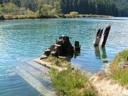
Timber
production is the primary land use in the area. The California Lumber Company built the first sawmill
on the Mendocino County coast at the mouth of the river in 1852. By 1873, the name had changed to Mendocino Lumber Company and the mill was the most important in Mendocino County. A railway line extended 9 miles (14 km) up the Big River to bring logs to the mill. The mill operated until 1931, and was briefly reopened in 1938 to mill logs salvaged when a log raft broke up off the coast. The North Fork Big River was logged by the Caspar Lumber Company. Logs were transported 35 miles (56.3 km) to the sawmill in Caspar
from Camp 20 at California State Route 20 milepost MEN 17.3 by their Caspar, South Fork and Eastern Railroad
. Caspar Lumber Company timberlands became Jackson Demonstration State Forest in 1955. Jackson State Forest forms roughly a third of the area in the watershed, and land owned by the lumber
companies Mendocino Redwood Company, Pioneer Resources, Hawthorne Timber Company and Weger Holdings make up most of the rest. As with most watersheds
on the northern coast of California, the most significant ecological problem in the area is increased erosion caused by logging
, leading to excessive sediment
ation in the river and its tributaries.
River
A river is a natural watercourse, usually freshwater, flowing towards an ocean, a lake, a sea, or another river. In a few cases, a river simply flows into the ground or dries up completely before reaching another body of water. Small rivers may also be called by several other names, including...
in Mendocino County, California
Mendocino County, California
Mendocino County is a county located on the north coast of the U.S. state of California, north of the greater San Francisco Bay Area and west of the Central Valley. As of the 2010 census, the population was 87,841, up from 86,265 at the 2000 census...
, draining an area of about 181 square miles (468.8 km²). The Big River watershed borders the watersheds of the Noyo River
Noyo River
The Noyo River is a river on the north coast of California in Mendocino County. The river's headwaters are in the steep Mendocino Range, but downstream the river flows through gently sloping marine terraces before draining into the Pacific Ocean...
to the north, the Eel River
Eel River (California)
The Eel River is a major river system of the northern Pacific coast of the U.S. state of California. Approximately 200 miles long, it drains a rugged area in the California Coast Ranges between the Sacramento Valley and the ocean. For most of its course, the river flows northwest, parallel to the...
and Russian River
Russian River (California)
The Russian River, a southward-flowing river, drains of Sonoma and Mendocino counties in Northern California. With an annual average discharge of approximately , it is the second largest river flowing through the nine county Greater San Francisco Bay Area with a mainstem 110 miles ...
to the east, and the Little River
Little River (Mendocino County)
Little River is a westward-flowing stream in Mendocino County, California which empties into the Pacific Ocean in Van Damme State Park near the town of Little River, California. Big River enters the Pacific about farther north....
, Albion River
Albion River
The Albion River is an river in Mendocino County, California. The river drains about on the Mendocino Coast and empties into the Pacific Ocean near the town of Albion, California, where California State Route 1 crosses it on the Albion River Bridge. The river's overall direction is east to west,...
, and Navarro River
Navarro River
The Navarro River is a river in Mendocino County, California. It flows northwest through the Coastal Range to the Pacific Ocean. Encompassing , its watershed includes the Anderson Valley, a well-known wine-growing region in Mendocino County. The main stem of the Navarro River begins less than ...
to the south.
Pacific Ocean
The Pacific Ocean is the largest of the Earth's oceanic divisions. It extends from the Arctic in the north to the Southern Ocean in the south, bounded by Asia and Australia in the west, and the Americas in the east.At 165.2 million square kilometres in area, this largest division of the World...
in the Mendocino Range
Mendocino Range
The Mendocino Range is one of several coastal mountain ranges which compose the Pacific Coast Range. This massive range of coastal mountains was formed during a period of coastal orogeny, millions of years ago. The Mendocino Range is a component of the California Coast Ranges of California...
, part of the California Coast Range
Coast Ranges (California)
The Coast Ranges of California constitute one of the eleven traditional geomorphic provinces of California. They include several but not all mountain ranges along the California coast...
. The headwater area of the river is fed by Montgomery Creek as it flows through the upland riparian habitat and virgin
Old growth forest
An old-growth forest is a forest that has attained great age , and thereby exhibits unique ecological features. An old growth forest has also usually reached a climax community...
redwoods of Montgomery Woods State Reserve
Montgomery Woods State Reserve
Montgomery Woods State Reserve is a state-owned park located in the Coastal Range in Mendocino County, California, United States. The Reserve occupies the headwaters of Montgomery Creek, a tributary of Big River, which flows into the Pacific Ocean at Mendocino Headlands State Park...
. From there, the river flows roughly west through Jackson Demonstration State Forest
Jackson Demonstration State Forest
Jackson Demonstration State Forest is the largest demonstration forest operated by the State of California. The forest is entirely located within Mendocino County on land formerly owned by Caspar Lumber Company along California State Highway 20 between Willits and the coastal city of Fort Bragg. ...
. The lower portions of the river pass through Mendocino Woodlands State Park
Mendocino Woodlands State Park
The Mendocino Woodlands State Park is a group camping facility located at 39350 Little Lake Road, Mendocino County, California, seven miles inland from the town of Mendocino. It was built as a Recreational Demonstration Area by the Civilian Conservation Corps...
and the Big River Unit of Mendocino Headlands State Park
Mendocino Headlands State Park
Mendocino Headlands State Park is a California State Park in Mendocino, California. It consists of of undeveloped seaside bluffs and islets surrounding the town of Mendocino, two beaches , and the much larger Big River Unit stretching for eight miles along both banks of the nearby Big River.The...
before reaching the mouth of the river at the Pacific Ocean just south of the town of Mendocino
Mendocino, California
Mendocino is a census-designated place in Mendocino County, California, United States. Mendocino is located south of Fort Bragg, at an elevation of 154 feet...
.
Habitat and ecology
The Big River is fed by precipitationPrecipitation (meteorology)
In meteorology, precipitation In meteorology, precipitation In meteorology, precipitation (also known as one of the classes of hydrometeors, which are atmospheric water phenomena is any product of the condensation of atmospheric water vapor that falls under gravity. The main forms of precipitation...
, 90 percent of which falls between October and April, and which averages 40 inches (101.6 cm) per year at Fort Bragg
Fort Bragg, California
Fort Bragg is a city located in coastal Mendocino County, California along State Route 1, the major north-south highway along the Pacific Coast. Fort Bragg is located west of Willits, at an elevation of 85 feet...
near the coast and 51 inches (129.5 cm) at Willits
Willits, California
Willits is a city in Mendocino County, California, United States. Willits is located north-northwest of Ukiah, at an elevation of 1391 feet . The population was 4,888 at the 2010 census, down from 5,073 at the 2000 census. Willits is at the center of Mendocino County and its redwood forests...
inland. Winter weather is characterized by low intensity rain
Rain
Rain is liquid precipitation, as opposed to non-liquid kinds of precipitation such as snow, hail and sleet. Rain requires the presence of a thick layer of the atmosphere to have temperatures above the melting point of water near and above the Earth's surface...
. The summer are dry and cool, with coastal fog
Fog
Fog is a collection of water droplets or ice crystals suspended in the air at or near the Earth's surface. While fog is a type of stratus cloud, the term "fog" is typically distinguished from the more generic term "cloud" in that fog is low-lying, and the moisture in the fog is often generated...
.
The Big River has an estuary
Estuary
An estuary is a partly enclosed coastal body of water with one or more rivers or streams flowing into it, and with a free connection to the open sea....
at its mouth that provide habitat
Habitat (ecology)
A habitat is an ecological or environmental area that is inhabited by a particular species of animal, plant or other type of organism...
for a wide variety of organisms. Salt water
Brackish water
Brackish water is water that has more salinity than fresh water, but not as much as seawater. It may result from mixing of seawater with fresh water, as in estuaries, or it may occur in brackish fossil aquifers. The word comes from the Middle Dutch root "brak," meaning "salty"...
from the ocean reaches 8.3 miles (13.4 km) upstream in the summer and 3 miles (5 km) in the winter, when flows are larger. The mouth, which closes in the summer on some rivers, stays open all year.
California Golden Beaver (Castor canadensis subauratus) were restored to Big River in the early to mid-twentieth century despite extirpation in the California Fur Rush
California Fur Rush
Before the 1849 California Gold Rush, American, English and Russian fur hunters were drawn to Spanish California in a California Fur Rush, to exploit its enormous fur resources...
of the late eighteenth and early nineteenth centuries. A specimen was collected by J. G. Hall 10 miles (16.1 km) east of Mendocino on the Big River at elevation 200 feet (61 m) (precise location 39.31148, -123.6396) in 1966 for the California Academy of Sciences
California Academy of Sciences
The California Academy of Sciences is among the largest museums of natural history in the world. The academy began in 1853 as a learned society and still carries out a large amount of original research, with exhibits and education becoming significant endeavors of the museum during the twentieth...
mammal collection. Beaver ponds help restore salmonid habitat by capturing sediment and improving water quality, providing pools for juvenile salmonid over-summering, raising water tables which recharge streams in the dry season, increasing the area of aquatic and riparian habitat providing fish cover, and attenuating flashy storm flows. A recent comprehensive literature review of the effects of beaver impoundments on fish illustrates that loss of beavers was directly related to significant population declines of now endangered California salmonids, including three species listed under the Endangered Species Act
Endangered Species Act
The Endangered Species Act of 1973 is one of the dozens of United States environmental laws passed in the 1970s. Signed into law by President Richard Nixon on December 28, 1973, it was designed to protect critically imperiled species from extinction as a "consequence of economic growth and...
: central California coast Coho salmon
Coho salmon
The Coho salmon, Oncorhynchus kisutch, is a species of anadromous fish in the salmon family. Coho salmon are also known as silver salmon or "silvers". It is the state animal of Chiba, Japan.-Description:...
(Oncorhynchus kisutch), central California coast steelhead trout (Oncorhynchus mykiss) and California coast Chinook salmon
Chinook salmon
The Chinook salmon, Oncorhynchus tshawytscha, is the largest species in the pacific salmon family. Other commonly used names for the species include King salmon, Quinnat salmon, Spring salmon and Tyee salmon...
(Oncorhynchus tshawytscha).
Timber
Timber
Timber may refer to:* Timber, a term common in the United Kingdom and Australia for wood materials * Timber, Oregon, an unincorporated community in the U.S...
production is the primary land use in the area. The California Lumber Company built the first sawmill
Sawmill
A sawmill is a facility where logs are cut into boards.-Sawmill process:A sawmill's basic operation is much like those of hundreds of years ago; a log enters on one end and dimensional lumber exits on the other end....
on the Mendocino County coast at the mouth of the river in 1852. By 1873, the name had changed to Mendocino Lumber Company and the mill was the most important in Mendocino County. A railway line extended 9 miles (14 km) up the Big River to bring logs to the mill. The mill operated until 1931, and was briefly reopened in 1938 to mill logs salvaged when a log raft broke up off the coast. The North Fork Big River was logged by the Caspar Lumber Company. Logs were transported 35 miles (56.3 km) to the sawmill in Caspar
Caspar, California
Caspar is a census-designated place in Mendocino County, California. It is located north of Mendocino, at an elevation of 82 feet . Caspar is located on the Pacific Ocean. In the Caspar area is the historic Point Cabrillo Light Station, which was built in 1909...
from Camp 20 at California State Route 20 milepost MEN 17.3 by their Caspar, South Fork and Eastern Railroad
Caspar, South Fork and Eastern Railroad
The Caspar, South Fork & Eastern Railroad provided transportation for the Caspar Lumber Company in Mendocino County, California. The railroad operated the first steam locomotive on the coast of Mendocino County in 1875...
. Caspar Lumber Company timberlands became Jackson Demonstration State Forest in 1955. Jackson State Forest forms roughly a third of the area in the watershed, and land owned by the lumber
Lumber
Lumber or timber is wood in any of its stages from felling through readiness for use as structural material for construction, or wood pulp for paper production....
companies Mendocino Redwood Company, Pioneer Resources, Hawthorne Timber Company and Weger Holdings make up most of the rest. As with most watersheds
Drainage basin
A drainage basin is an extent or an area of land where surface water from rain and melting snow or ice converges to a single point, usually the exit of the basin, where the waters join another waterbody, such as a river, lake, reservoir, estuary, wetland, sea, or ocean...
on the northern coast of California, the most significant ecological problem in the area is increased erosion caused by logging
Logging
Logging is the cutting, skidding, on-site processing, and loading of trees or logs onto trucks.In forestry, the term logging is sometimes used in a narrow sense concerning the logistics of moving wood from the stump to somewhere outside the forest, usually a sawmill or a lumber yard...
, leading to excessive sediment
Sediment
Sediment is naturally occurring material that is broken down by processes of weathering and erosion, and is subsequently transported by the action of fluids such as wind, water, or ice, and/or by the force of gravity acting on the particle itself....
ation in the river and its tributaries.