
Nacimiento River
Encyclopedia
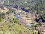
The Nacimiento River is a 64.8 miles (104.3 km) river
in southern Monterey County
and northern San Luis Obispo County, California
. A large portion of the river's run is on military reservations
. The river's upper reaches are inside Fort Hunter Liggett
, Lake Nacimiento is in the middle and the lower reaches are inside Camp Roberts
.
, part of the Coast Ranges, the river travels southeast from its headwaters through generally hilly terrain. Further on, the Nacimiento Dam forms Lake Nacimiento
, the largest in San Luis Obispo County. Downstream from the dam, the river travels east until it joins the Salinas River
at Camp Roberts
, Monterey County. The San Antonio River
, which feeds Lake San Antonio
and is also a Salinas River tributary, mirrors Nacimiento's path several miles to the northeast. The river provides water for irrigation
and groundwater
recharge. The lake is also a popular site for recreation, such as swimming, boating
, fishing
and water skiing
.
River
A river is a natural watercourse, usually freshwater, flowing towards an ocean, a lake, a sea, or another river. In a few cases, a river simply flows into the ground or dries up completely before reaching another body of water. Small rivers may also be called by several other names, including...
in southern Monterey County
Monterey County, California
Monterey County is a county located on the Pacific coast of the U.S. state of California, its northwestern section forming the southern half of Monterey Bay. The northern half of the bay is in Santa Cruz County. As of 2010, the population was 415,057. The county seat and largest city is Salinas...
and northern San Luis Obispo County, California
San Luis Obispo County, California
San Luis Obispo County is a county located along the Pacific Ocean in the Central Coast of the U.S. state of California, between Los Angeles and the San Francisco Bay Area. As of the 2010 census its population was 269,637, up from 246,681 at the 2000 census...
. A large portion of the river's run is on military reservations
Military base
A military base is a facility directly owned and operated by or for the military or one of its branches that shelters military equipment and personnel, and facilitates training and operations. In general, a military base provides accommodations for one or more units, but it may also be used as a...
. The river's upper reaches are inside Fort Hunter Liggett
Fort Hunter Liggett
Fort Hunter Liggett , named after General Hunter Liggett in 1941, is a United States Army fort in southern Monterey County, California, about 250 miles north of Los Angeles and south of San Francisco...
, Lake Nacimiento is in the middle and the lower reaches are inside Camp Roberts
Camp Roberts, California
Camp Roberts is a California National Guard post in central California, located on both sides of the Salinas River in Monterey and San Luis Obispo counties, now run by the California Army National Guard. It is named after Harold W. Roberts, a World War I Medal of Honor recipient...
.
Geography
Rising on the east side of the Santa Lucia MountainsSanta Lucia Mountains
The Santa Lucia Mountains or Santa Lucia Range is a mountain range in coastal California, running from Monterey southeast for 105 miles to San Luis Obispo. The highest summit is Junipero Serra Peak, in Monterey County...
, part of the Coast Ranges, the river travels southeast from its headwaters through generally hilly terrain. Further on, the Nacimiento Dam forms Lake Nacimiento
Lake Nacimiento
Lake Nacimiento is an long lake on the Nacimiento River in northern San Luis Obispo County, California. The lake contains many arms including Snake Creek and Dip Creek, nearer the dam, and the central Las Tablas and Franklin Creeks. Because of the dragon-like shape created by the positions of...
, the largest in San Luis Obispo County. Downstream from the dam, the river travels east until it joins the Salinas River
Salinas River (California)
The Salinas River is the largest river of the central coast of California, running and draining 4,160 square miles. It flows north-northwest and drains the Salinas Valley that slices through the Coast Range south from Monterey Bay...
at Camp Roberts
Camp Roberts, California
Camp Roberts is a California National Guard post in central California, located on both sides of the Salinas River in Monterey and San Luis Obispo counties, now run by the California Army National Guard. It is named after Harold W. Roberts, a World War I Medal of Honor recipient...
, Monterey County. The San Antonio River
San Antonio River (California)
The San Antonio River is a river in southern Monterey County, California.-Geography:The river travels southeast from its headwaters in the Santa Lucia Range in the Los Padres National Forest and into Lake San Antonio. This is a reservoir behind the San Antonio Dam, an earth-fill dam on the river...
, which feeds Lake San Antonio
Lake San Antonio
Lake San Antonio is a lake in southern Monterey County, California. The lake is formed by an earthfill dam on the San Antonio River. The dam is 202 feet tall and was completed in 1965 under Monterey County District Engineer Loran Bunte Jr . The lake and dam are owned by the Monterey County Water...
and is also a Salinas River tributary, mirrors Nacimiento's path several miles to the northeast. The river provides water for irrigation
Irrigation
Irrigation may be defined as the science of artificial application of water to the land or soil. It is used to assist in the growing of agricultural crops, maintenance of landscapes, and revegetation of disturbed soils in dry areas and during periods of inadequate rainfall...
and groundwater
Groundwater
Groundwater is water located beneath the ground surface in soil pore spaces and in the fractures of rock formations. A unit of rock or an unconsolidated deposit is called an aquifer when it can yield a usable quantity of water. The depth at which soil pore spaces or fractures and voids in rock...
recharge. The lake is also a popular site for recreation, such as swimming, boating
Boating
Boating is the leisurely activity of travelling by boat, or the recreational use of a boat whether powerboats, sailboats, or man-powered vessels , focused on the travel itself, as well as sports activities, such as fishing or water skiing...
, fishing
Fishing
Fishing is the activity of trying to catch wild fish. Fish are normally caught in the wild. Techniques for catching fish include hand gathering, spearing, netting, angling and trapping....
and water skiing
Water skiing
thumb|right|A slalom skier making a turn on a slalom waterski.Waterskiing is a sport where an individual is pulled behind a boat or a cable ski installation on a body of water, skimming the surface.-History:...
.