
Chowchilla River
Encyclopedia
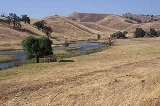
The Chowchilla River is a river
in central California
and a minor tributary of the San Joaquin River
. It flows for 54.2 miles (87.2 km) from the western side of the Sierra Nevada Range to the San Joaquin River system. Most of the lower half of the river forms the border between Merced
and Madera County
.
.
. It flows roughly south from Bootjack, receiving Pegleg Creek, Humbug Creek, Italian Creek and Blade Creek before converging with the Middle Fork.
. It flows roughly south past the locality of Harris Ranch, receiving Oliver Creek and several other small, unnamed tributaries along the way. It converges with the West Fork south of Bailey Flats, and a few miles south of where the Middle and West Forks converge.
and Chowchilla
areas.
Below Eastman Lake, the river continues roughly west, past the City of Chowchilla, to the San Joaquin River System.
The main river channel ends abruptly about three miles (5 km) east of the San Joaquin River. The river has never had a defined natural outlet to the San Joaquin, as evidenced by the fact that the riverbed shrinks considerably in size as it travels west. A natural outlet never existed because the river only has a seasonal flow, and natural water flow would normally dry up before it had a chance to reach the San Joaquin. In rare years of torrential rains, there would still be water in the river at the end of the riverbed, at which point the water would simply flood the area past the end of the riverbed. Those floodwaters would eventually find their way into the San Joaquin River.
As part of the Lower San Joaquin River Flood Control Project, a diversion canal was built to connect the end of the riverbed with the Eastside Bypass, allowing the Chowchilla's water a controlled outlet to the San Joaquin River during years of heavy rains.
The Chowchilla River serves at the outlet of the Madera Canal
.
River
A river is a natural watercourse, usually freshwater, flowing towards an ocean, a lake, a sea, or another river. In a few cases, a river simply flows into the ground or dries up completely before reaching another body of water. Small rivers may also be called by several other names, including...
in central California
Central California
Central California, sometimes referenced as Mid-State, is an area of California south of the San Francisco Bay Area and north of Southern California...
and a minor tributary of the San Joaquin River
San Joaquin River
The San Joaquin River is the largest river of Central California in the United States. At over long, the river starts in the high Sierra Nevada, and flows through a rich agricultural region known as the San Joaquin Valley before reaching Suisun Bay, San Francisco Bay, and the Pacific Ocean...
. It flows for 54.2 miles (87.2 km) from the western side of the Sierra Nevada Range to the San Joaquin River system. Most of the lower half of the river forms the border between Merced
Merced County, California
Merced County , is a county located in the Central Valley of the U.S. state of California, north of Fresno and southeast of San Jose. As of the 2010 census, the population was 255,793, up from 210,554 at the 2000 census. The county seat is Merced...
and Madera County
Madera County, California
Madera County is a county of the U.S. state of California, located in the Central Valley and the Sierra Nevada north of Fresno County. It comprises the Madera-Chowchilla, CA Metropolitan Statistical Area. As of the 2010 census the population was 150,865...
.
Course
The river begins as three separate forks in southern Mariposa CountyMariposa County, California
Mariposa County is a county in the U.S. state of California, located in the western foothills of the Sierra Nevada mountains. It lies north of Fresno, east of Merced, and southeast of Stockton. As of the 2010 census, the population was 18,251 up from 17,130 at the 2000 census...
.
West Fork
The West Fork (officially known as West Fork Chowchilla River) is formed by the confluence of Jones Creek and Snow Creek, north of the town of Bootjack, CaliforniaBootjack, California
Bootjack is an unincorporated community and census-designated place in Mariposa County, California, United States. Bootjack is located east-southeast of Mariposa, at an elevation of 2238 feet...
. It flows roughly south from Bootjack, receiving Pegleg Creek, Humbug Creek, Italian Creek and Blade Creek before converging with the Middle Fork.
Middle Fork
The Middle Fork (officially known as Middle Fork Chowchilla River) is formed by the confluence of Magoon Creek and Fox Creek, on the east side of Magoon Hill in the Sierra Nevadas. It flows roughly south along the west side of Stumpfield Mountain, receiving a few unnamed tributaries, before converging with the West Fork.East Fork
The East Fork (officially known as East Fork Chowchilla River) is the longest of the three forks and is formed by the confluence of several small, unnamed streams on the south side of Chowchilla Mountain, in the Sierra National ForestSierra National Forest
Sierra National Forest is a U.S. National Forest located on the western slope of central Sierra Nevada in the state of California. The forest is known for its mountain scenery and natural resources. Forest headquarters are located in Clovis, California...
. It flows roughly south past the locality of Harris Ranch, receiving Oliver Creek and several other small, unnamed tributaries along the way. It converges with the West Fork south of Bailey Flats, and a few miles south of where the Middle and West Forks converge.
Main river
The Chowchilla River begins in name at the point where the West and East forks converge and flows southwest to Eastman Lake. The lake, which holds 150000 acre.ft of water from the Chowchilla, was created in 1975 by the construction of Buchanan Dam, an earth and rockfill structure which is 205 ft (62 m) high and 1800 ft (550 m) long. The lake and dam's primary purpose is flood control and irrigation. In the summer months, Eastman Lake is a popular boating, fishing, camping and hiking destination for residents of the MaderaMadera, California
Madera is a city in and the county seat of Madera County, California, United States. It is a principal city of the Madera–Chowchilla Metropolitan Statistical Area, which encompasses all of Madera County, and Metropolitan Fresno. It is located in California's San Joaquin Valley. As of the 2010...
and Chowchilla
Chowchilla, California
Chowchilla is a city in Madera County, California, United States. Chowchilla is located northwest of Madera, at an elevation of 240 feet . It is a principal city of the Madera–Chowchilla Metropolitan Statistical Area. The population was 18,720 at the 2010 census, up from 11,127 at the 2000...
areas.
Below Eastman Lake, the river continues roughly west, past the City of Chowchilla, to the San Joaquin River System.
Lower river
Seven miles downstream of Eastman Lake, the Chowchilla's water is diverted into both the Berenda and Ash sloughs, with excess water continuing down the main river channel. The river flows west-southwest for most of the rest of the journey before flowing west in the last few miles. The last two miles (3 km) of the river doubles as an irrigation canal for farms located along its banks.The main river channel ends abruptly about three miles (5 km) east of the San Joaquin River. The river has never had a defined natural outlet to the San Joaquin, as evidenced by the fact that the riverbed shrinks considerably in size as it travels west. A natural outlet never existed because the river only has a seasonal flow, and natural water flow would normally dry up before it had a chance to reach the San Joaquin. In rare years of torrential rains, there would still be water in the river at the end of the riverbed, at which point the water would simply flood the area past the end of the riverbed. Those floodwaters would eventually find their way into the San Joaquin River.
As part of the Lower San Joaquin River Flood Control Project, a diversion canal was built to connect the end of the riverbed with the Eastside Bypass, allowing the Chowchilla's water a controlled outlet to the San Joaquin River during years of heavy rains.
The Chowchilla River serves at the outlet of the Madera Canal
Madera Canal
The Madera Canal is a aqueduct in the U.S. state of California. It is part of the Central Valley Project managed by the United States Bureau of Reclamation to convey water north to augment irrigation capacity in Madera County, California. It was also the subject of the United States Supreme...
.
Tributaries
In addition to many small unnamed streams, the Chowchilla River receives the water from the following streams:- Rock Creek
- Willow Creek
- Split Rock Creek
- Cow Creek
Towns
Towns along the Chowchilla River include:- Harris Ranch (Unincorporated)
- BootjackBootjack, CaliforniaBootjack is an unincorporated community and census-designated place in Mariposa County, California, United States. Bootjack is located east-southeast of Mariposa, at an elevation of 2238 feet...
(Unincorporated) - RaymondRaymond, CaliforniaRaymond is an unincorporated community in Madera County, California. It is located north-northeast of Madera, at an elevation of 948 feet ....
(Unincorporated) - ChowchillaChowchilla, CaliforniaChowchilla is a city in Madera County, California, United States. Chowchilla is located northwest of Madera, at an elevation of 240 feet . It is a principal city of the Madera–Chowchilla Metropolitan Statistical Area. The population was 18,720 at the 2010 census, up from 11,127 at the 2000...
Crossings
There are numerous crossings over the Chowchilla River in Madera and Merced Counties. Crossings are listed here beginning at the source and working downstream:- Madera County above Eastman Lake
- Bailey Flats Road
- Green Mountain Road
- Madera County below Eastman Lake
- Eastman Lake Park Access Road
- Santa Fe Drive
- Santa Fe Railroad next to Santa Fe Drive crossing
- Road 19
- Road 15
- State Route 99California State Route 99California State Route 99 , commonly known as Highway 99 or, simply, as 99 , is a north–south state highway in the U.S. state of California, stretching almost the entire length of the Central Valley...
- Road 13
- Avenue 26
- Road 11
- Hemlock Road
- Road 8
- Avenue 25
- Road 5½
- Road 5
- Merced County
- South Orchard Way
- State Route 59California State Route 59State Route 59 is a California state highway that connects State Route 152 to the city of Merced and beyond, ending abruptly at the intersection of County Routes J59 and J16 in Snelling.-Route description:...
External links
- Wildernet - Eastman Lake
- San Joaquin River White Paper
- The point where the Chowchilla River is directed to a diversion canal (Windows Live Local or Google Maps)