
San Juan Creek
Encyclopedia
San Juan Creek, also called the San Juan River, is a 29 miles (46.7 km) stream in Orange County, California
that consists of a catchment basin encompassing 133.9 square miles (346.8 km²). Its mainstem
rises in the Santa Ana Mountains
, in the Trabuco Ranger District of the Cleveland National Forest
. From there it runs parallel to the Ortega Highway
as it winds west and south through San Juan Canyon, where it is joined by numerous small tributaries, and is joined by Trabuco
Creek, its main branch as it passes through San Juan Capistrano. It flows into the Pacific Ocean
at Doheny State Beach
. Once out of the foothills, San Juan Creek flows through the city of San Juan Capistrano
where groundwater flow direction generally is from the northeast to the southwest. Groundwater in this basin at the San Juan Capistrano reach is considered good. Recent efforts of stream conservation have been in the planning stage including habitat conservation
plan work.
Historically, the San Juan Creek watershed was inhabited by the Acjachemen, now Juañeno Indians. The Juañeno received their current name from Spanish conquistador
s in the 1770s, who built Mission San Juan Capistrano
very near San Juan Creek, giving it its name. After the Spanish settlement, development in the watershed continued to grow and pollution of the creek has increased. The construction of Dana Point Harbor in 1960 increased the pollution of San Juan Creek at its mouth, posing an increasing danger to visitors of Doheny State Beach. In the late 1990s and early 21st century, floods destroyed many river control structures in the San Juan watershed, and the risk of floods continues to grow.
Although the San Juan watershed was formerly rich in biodiversity, with sixteen major plant communities and hundreds of species of birds, invertebrates, mammals, and others, the watershed is projected to be 48 percent developed by the year 2050. Many reaches of open land in the San Juan watershed are now heavily developed, and urban runoff
coming from residential communities is taking an increased toll on the creek and its tributaries. Although the mainstem San Juan Creek does not have any water diversions or dams, its tributaries are heavily affected, most notably Trabuco and Oso Creeks.
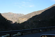 San Juan Creek begins high in the Santa Ana Mountains
northwest of Lake Elsinore
, in a steep and narrow canyon known as San Juan Canyon, at roughly 5100 feet (1,554.5 m) in elevation. From there, it flows steeply downhill over riffles and waterfalls, and soon begins to parallel California State Route 74
, here known as the Ortega Highway, as it winds through the rocky gorge. It drops over San Juan Falls, a 15 feet (4.6 m) cascade, then crosses under an arch bridge
that carries the Ortega Highway. It is joined by Hot Springs Creek and Cold Springs Creek on the right bank, while Lucas Canyon Creek meets it on the left.
Once out of the mountains, San Juan Creek proceeds to meander
through a broad and shallow farming and ranching valley underlain by thick alluvial deposits. The creek swings west to receive Bell Canyon
on the right, from several residential communities that overlook, but do not border, it. and Verdugo Canyon Creek from the left. Trampas Canyon
enters from the left and Cañada Gobernadora
and Cañada Chiquita enter from the right. The creek then crosses under Interstate 5
, and enters a flood control channel
, turning south and receiving El Horno Creek
on the right. It receives its largest tributary, Trabuco Creek
, on the right bank, then continues south and east to the Pacific Ocean
. Before it reaches the sea, however, it enters a lagoon
at the northern end of Doheny State Beach
, which occasionally spills into Capistrano Bay.
All direct tributaries of San Juan Creek, from mouth to source, are listed. The list does not include streams that join major tributaries.
 The geology of the San Juan Creek watershed is complex, but can be described as having many seismic fault zones, with streams tending to follow these fault zones where canyons have formed, and having extremely erosive soils. The alluvial floodplain
of San Juan Creek tends to have very deep concentrations in lower reaches and are said to be poorly drained. Soil types in the San Juan watershed can be divided into the Metz-San Emigdio, Sorrento-Mocho, Myford. Alo-Bosanko, Cieneba-Anaheim-Soper, and Friant-Cieneba-Exchequer associations, in order from most level to steepest. Sedimentary bedrock composes many hillsides in the San Juan watershed, and poses a landslide danger during earthquakes, severe erosion or other events that may cause failure of hillside stability.
There are also several seismic faults within the watershed. These include a fault line (Cristianitos) running along Oso Creek
northeast-southwest, passing offshore 7 miles (11.3 km) south of the mouth of San Juan Creek, as well as another fault zone (Mission Viejo) that parallels the Cristianitos but ends far more south, in San Diego County. In summary, the San Juan watershed can be considered as being bisected by two faults, running through its approximate center. The first recorded earthquake in the area partially destroyed Mission San Juan Capistrano
in 1812, followed by others in 1862, 1933 and 1938.
The uplift of the San Joaquin Hills
, a small coastal mountain range generally following the Pacific coast of Orange County, created a physical barrier for streams flowing off the Santa Ana Mountains. But by the Wisconsinian Glaciation, an enormous climate change helped solve that problem. During the Wisconsinian Glaciation, a period of time that lasted from about 70,000 to 10,000 years ago, glacier
s and ice sheet
s moved south from Canada
into the northern United States, radically altering the climate of the entire continent. The arid Southern California climate was supplanted by a temperate rainforest climate that would receive rainfall in excess of 80 to 90 in (2,032 to 2,286 mm) per year. San Juan Creek and other streams along the South Coast became powerful rivers that cut their way through the San Joaquin Hills, but this condition reverted by the end of the period. Several wet periods did occur throughout the Ice Age, but the Wisconsinian was the largest.
in the San Juan Creek basin, also referred to as the "San Juan Creek Groundwater Basin", has a total volume of roughly 900000 acre.ft. (California State Water Resources Control Board, 1977.) Natural groundwater recharge in the San Juan basin is estimated to be roughly 160000 acre.ft per year historically, mostly from precipitation. This amount has been reduced due to extensive development of the lower segment of the watershed, which is continuing to reduce the amount of open ground that can potentially serve in groundwater recharge. Artificially sourced water from irrigation
and other uses is responsible for recharging roughly 37500 acre.ft annually. The watershed is essentially split into half by the Christianitos and Mission Viejo fault zones, which result in the division of the "Upper" and "Lower" groundwater basins. The groundwater mostly lies in alluvium
, which ranges from a depth of 200 feet (61 m) in the lower watershed to mostly none in the upper reaches of the watershed.
 Historically, the total surface outflow from the San Juan basin into the Pacific was calculated at 5200 acre.ft annually. Increasing urban development, resulting in increased runoff from irrigation and other sources, brought the annual outflow to 7800 acre.ft as of 1993. The maximum annual yield is 9000 acre.ft. Although water from San Juan Creek, tributaries and basin groundwater are increasingly used for a limited amount of agricultural and municipal purposes, the annual yield from the watershed is continually increasing. As the groundwater recharge rate of the watershed is relatively high, it is safe to assume that groundwater levels will recover quickly from human use and human-induced pollution.
Due to the lower amount of urbanization in the San Juan watershed as compared with other watersheds in the county, the 100-year flood
inundation risk is also significantly lower than that of most of the nearby watersheds. It has been calculated that a 100-year flood in the watershed would only affect a roughly 0.5 mi (0.80467 km) wide area for the lower reaches of San Juan Creek inside San Juan Capistrano, while for Trabuco Creek, only a 0.2 mi (0.321868 km) wide area would be affected, mainly due to severe downcutting. A fact of note is that the failure of the earthen Trampas Canyon Dam (in Trampas Canyon
, 2 miles (3.2 km) upstream of San Juan Capistrano) would actually create a floodwave slightly larger than that of the 100 year flood that would race down San Juan Creek to its mouth. However, many levees in the San Juan area are still inadequately suited to a 100 year flood, regardless of the extent.
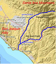
 The Santa Ana Mountains
occupy most of the north, east and south parts of the approximately 133.9 square miles (346.8 km²) San Juan Creek watershed, while the San Joaquin Hills
and one of their small subranges border the watershed on the southwest, east, and northwest. The three major tributaries, San Juan, Trabuco and Bell Creeks, all originate in the Santa Ana Mountains. There are four main alluvial river valleys in the watershed, drained by San Juan, Trabuco, Oso and Bell Creeks. The San Juan Creek valley occupies the south portion of the watershed, running roughly south before spreading wider near the coast, and running northeast until it turns sharply to the southeast to meet the Pacific Ocean
at the city of Dana Point
. The Trabuco Creek valley runs west from the northeasternmost portion of the watershed, then gradually becomes wider in a section called the Plano Trabuco then it joins the smaller, urbanized valley of Oso Creek, which runs primarily south. The combined valley then runs southward to merge with the San Juan Creek valley in San Juan Capistrano. The Bell Creek valley is narrower, beginning a few miles south of Trabuco Canyon, California
, and running in an almost perfectly straight southward course to San Juan Creek, which at this point is shortly out of the uppermost reach of its watershed, San Juan Canyon. There are 19 other major creeks in the watershed, including Tijeras Canyon Creek and El Horno Creek
, both of which drain parts of the foothills
of the Santa Ana Mountains.
San Juan Creek is considered as part of the 500 square miles (1,295 km²) San Juan Hydrologic Unit, which is a coastal region running from central-south Orange County to the north extent of San Diego County, which borders Orange County on the south. The hydrologic unit also covers the watersheds of Aliso Creek, Salt Creek, Prima Deshecha Cañada, Segunda Deshecha Cañada, and San Mateo Creek
, in order from north to south. Elevation above sea level ranges from 0 to 5700 ft (0 to 1,737.4 m), and precipitation in the hydrologic unit ranges from 12 to 16 in (304.8 to 406.4 mm) annually. Except for San Mateo Creek, all of the other streams in the unit have a relatively developed watershed. San Juan Creek receives extra runoff from agriculture, urban activities, commercial irrigation, and other human-induced sources, which creates an extra unnatural flow (consisting of urban runoff
and agricultural return flows). This runoff is often polluted by trash, heavy metals, and oil
received while running over pavement, and pesticide
s and fertilizer
if draining farmland. A specific point of concern in the watershed is Oso Creek
. A Southern California environmentalist, Michael Hazzard, said after diving into Upper Oso Creek Reservoir to retrieve an outboard motor
:
s totaling over 300 acres (1.2 km²) historically in the lower reaches, before the rapid population explosion of Orange County began. There are 16 major vegetation zones in the watershed. Currently, the total wetland acreage in the watershed is 3 acre (0.01214058 km²), or one percent of the historic total. In 1987, just five bird species were confirmed in the watershed, while for fish
, benthic invertebrate
s, and certain insect
s there were no confirmed observations, in part due to insufficient site coverage. Steelhead trout have recently been observed in the creek and its tributary, Trabuco Creek. A further reason for the decline of creek habitat and wildlife is mainly due to invasive plant and animal species, including giant reed (Arundo donax) and many sport fishes, such as bluegill
and striped bass
. However, a notable aspect of the creek water is while a sample taken at the creek mouth in January 1995 had a temperature of 13.8oC (56.84 degrees Fahrenheit), many creeks along the Orange County coast have much higher temperatures.
s on San Juan Creek in the city of San Juan Capistrano, one from 1929 to 1969 and the second from 1970 to 1984. For the former gauge, the highest recorded peak flow during that period was 22400 cuft/s per second on 25 February 1969, with a gauge height of 5.6 feet (1.7 m). The second highest peak flow during that period was 13000 cuft/s on 2 March 1938, presumably at the peak of the Los Angeles Flood of 1938
. For the more recent stream gauge, the highest recorded flow was 14700 cuft/s on 4 March 1978, gauge height 17 feet (5.2 m). The second highest flow was 11700 cuft/s on 20 February 1980, gauge height 15.43 feet (4.7 m). The highest flow recorded on San Juan Creek of all time, however, was not by a USGS stream gauge; the flow of 33650 cuft/s was recorded on 11 January 2005.
 Before the 18th century, San Juan Creek and its tributary, Trabuco Creek, had indigenous names, but these are thus far unknown. The land in the San Juan watershed was mostly Acjachemen Indian
territory, which extended from Aliso Creek in the north to San Mateo Creek
in the south, a distance of roughly 35 miles (56.3 km) north-south. Most of the population centered on the outfalls of the two large perennial streams in the area, San Juan and San Mateo Creeks, as well as Trabuco Creek.
Such inhabitants, who numbered roughly two thousand overall, were hunter-gatherers, living in small, semi-permanent villages beside or near perennial streams. There were five villages on the main stem, three of which were below the Trabuco Creek confluence, and four more in other parts of the watershed, mostly on Trabuco and Oso Creeks. Their diet usually consisted of fruits, acorns, and grains, and sometimes meat, while they practiced little agriculture. Shell midden
s indicate that they also harvested shellfish
from the coast. Although natural disasters such as floods, drought, and wildfires occurred during that time, as they do today, the Juañeno did not affect the environment of the area in either a negative or positive way. No permanent structures were built in the San Juan watershed until the arrival of the Spanish.
on a site that was most probably close to the creek, and as a result, the creek takes its name from the mission. The first site, however, was abandoned due to lack of water, although the creek was known in historical accounts to be perennial. The mission was moved to a second site, where it now stands. The Acjachemen were dubbed the "Juañeno" by the Spanish, after the mission. The Spanish were among the first to create hydrological changes in the San Juan watershed, which included excavating irrigation channels, diverting water from streams, and channelizing and changing course of streams. Grazing animals, including cows, sheep and other livestock, began their prevalence during this period, destroying many native grasses and leaving the ecosystem unbalanced and prone to erosion.
 The origin of the name of Trabuco Creek (Spanish: "Blunderbuss Creek", literally) stems from the Gaspar de Portola
expedition of 1769, during which a soldier lost a blunderbuss
("trabuco"), and the name became associated with the creek after that point. The origin of the name of Oso Creek (Spanish: "Bear Creek") is not known. Many of the creeks in the watershed have names of Spanish origin, which were most likely named by the Spanish conquistadors a long time before the area was annexed by the United States
.
In 1812, a heavy earthquake severely damaged many of the structures built by the Spanish. The Great Stone Church at Mission San Juan Capistrano, which had been built only six years before, collapsed; over forty people were reported to have been killed.
Before urban development, the partially devastated lands caused by overgrazing during the Spanish period was still potentially capable of rebounding to their natural state.
In 1964, the urban percentage was 3, while by 1988, it had increased to 18 percent. In the 1990s, the watershed was 32 percent urban, and the projected growth by 2050 is 50 percent. Many areas in the watershed now have no chance to revert back to their natural state as long as human habitation continues.
", in the bay. With the disappearance of Killer Dana, water circulation in the bay decreased. Resultantly, as pollution from San Juan Creek continued to flow freely into the bay, it stayed there for a longer period of time in comparison with that if the harbor had never been built. The pollution problems are ongoing, posing problems at Doheny Beach, where the 850,000 annual visitors are threatened by the continuing pollution from San Juan Creek.
 During floods in the 1990s, an almost sheer 30 feet (9.1 m) waterfall
was rapidly scoured out of a steep earthen slope on Trabuco Creek, downstream of a railroad bridge and upstream of the Oso Creek confluence. This drop required quick reinforcement with grout
ed riprap
, and still exists, with an average gradient of 29 percent before sheerly plunging into a murky stream pool
. It still poses a major barrier to migrating fish and other riverine organisms, and thus isolates the lower few miles of Trabuco Creek from the relatively natural upper course.
In 1996, severe floods caused by heavy rainstorms in the San Juan watershed caused both San Juan and Trabuco creeks to overflow, destroying long sections of concrete lining near their confluence. The damage was chiefly caused by severe basal erosion
, which led to subsequent failure of the concrete walls and levees. Once the concrete was breached, the bare earth underlying it was exposed to erosion, threatening a nearby residential community, but the floods receded before any serious harm was done. The failed sections were repaired with grout
ed riprap
, which can still be seen today.
In early 2005, even more severe floods that also caused flooding along area streams such as San Diego Creek
and Aliso Creek impacted the San Juan watershed, with an all-time highest flow of 33650 cuft/s recorded on January 11. Although the floods did not exceed the San Juan Creek channel capacity of 58800 cuft/s, the west levee of the channel inside San Juan Capistrano nearly failed.
Also in 2005, pumps were installed on Tick and Dove Creeks (tributaries of Bell Canyon, which flows into San Juan Creek) to remove urban runoff stemming from a 1100 acres (4.5 km²) residential community on a nearby ridge. The pumps remove excess flow and divert it to storage basins for later use as reclaimed irrigation water.
In May 2009, it was announced that levee
repairs along San Juan Creek would close a popular bikeway for up to two years, with repairs finished later in 2013. This spurred protests from many area residents who are common users of the path.
 Although most streams in the San Juan watershed are less developed than those in the neighboring Aliso Creek and Salt Creek watersheds, San Juan, Oso and Trabuco Creeks have undergone an extensive series of modifications designed to control floods, reduce excessive erosion, and provide reclaimed water
for irrigation. A growing amount of urban runoff
flows into the creek and its tributaries, adding to the excessive perennial flow referred to often as a "nuisance flow" or "dry season nuisance flow". Historically, only San Juan and Trabuco creeks were known to be perennial, while most of the tributaries, except for spring-fed ones such as Holy Jim Creek, were ephemeral. Oso Creek was formerly ephemeral, but currently it can flow in excess of 100 cuft/s in up to ten percent of an year. Finally, the long series of human-made modifications to the creek have resulted in its mouth, Doheny State Beach
, placing tenth in the most polluted beaches of California.
San Juan Creek is channelized from immediately upstream of the Interstate 5 crossing, and remains that way for its entire length until its mouth. Trabuco Creek is relatively unchannelized, but is channelized for several hundred yards above its confluence with San Juan. In sharp contrast is Oso Creek, which is channelized along nearly its entire length, while Bell Canyon is free-flowing. Two large reservoirs, Upper Oso and Lake Mission Viejo
, are built on Oso Creek. While Lake Mission Viejo is primarily for recreation, the 115 acre (0.4653889 km²) Upper Oso Reservoir collects Oso Creek water and diverts it for irrigation use, while any low-flow spillage that occurs over its dam is collected at a small downstream dam that feeds a pipe that pumps it back to the reservoir; in this way the Upper Oso Reservoir can be considered as a pumped-storage operation, although it does not produce hydroelectricity
. A notable aspect of the reservoir is that it was vital in providing water to extinguish a large wildfire
in October 2002. The dam is rockfill, 800 feet (243.8 m) long and 142 feet (43.3 m) high.
A few check dam
s exist on small upper tributaries of San Juan Creek, mostly inside the Cleveland National Forest
, as well as a small, abandoned gabion
structure lower on San Juan Creek. The structure, which was formerly a small dam, is now out of operation, but its roughly 3 to 4 ft (0.9144 to 1.2 m) drop still poses a problem for migrating steelhead trout. There are a few water diversion weirs that exist on San Juan tributary streams to divert water for irrigation, ranching and limited municipal uses, but due to limited flows and polluted water, the usefulness of these structures are limited.
A number of drop structure
s, which are small dams used to control water velocity, exist on streams in the San Juan watershed, primarily also on Trabuco and Oso creeks. On Trabuco Creek, there are eight drop structures, mostly built of riprap. The largest are a 30 feet (9.1 m) cascade immediately downstream of a Metrolink
bridge and a concrete drop structure at the terminus of a culvert
that crosses underneath Interstate 5
; however, neither is inventoried by the Orange County Flood Control Division. There are also about seven drop structures on Oso Creek, most of which are also built of riprap. The mainstem San Juan Creek does not have any notable drop structures, dams or water diversions.
As with channelization, levee
s are only found in the lower San Juan watershed. San Juan Creek is bounded with levees from upstream of Interstate 5 to very near its mouth at Doheny Beach, while Trabuco Creek has levees from upstream of Del Obispo Street (a continuation of the Ortega Highway) downstream to its mouth at San Juan Creek. Oso Creek has some raised banks, but it is not certain if those are levees. Smaller tributaries, such as El Horno Creek
and Bell Canyon
, do not have levees. Although the San Juan and Trabuco Creek levees are said to have a "fairly high level of protection currently", failure scenarios of levees in the San Juan watershed have been extensively studied, and they have been determined to possibly fail for a variety of reasons, some of which have already been demonstrated in the floods of 1996 and 2005. In response to the danger of another flood, work has begun on a new west-bank levee replacement that will finish in 2013.
Orange County, California
Orange County is a county in the U.S. state of California. Its county seat is Santa Ana. As of the 2010 census, its population was 3,010,232, up from 2,846,293 at the 2000 census, making it the third most populous county in California, behind Los Angeles County and San Diego County...
that consists of a catchment basin encompassing 133.9 square miles (346.8 km²). Its mainstem
Mainstem (hydrology)
In relation to hydrology, a main stem is "the primary downstream segment of a river, as contrasted to its tributaries". Another common term for the main stem, the final large channel of a riverine system, is the trunk. Water enters the main stem from the river's drainage basin, the land area...
rises in the Santa Ana Mountains
Santa Ana Mountains
The Santa Ana Mountains are a short peninsular mountain range along the coast of Southern California in the United States. They extend for approximately 36 mi southeast of the Los Angeles Basin largely along the border between Orange and Riverside counties.- Geography :The range starts in the...
, in the Trabuco Ranger District of the Cleveland National Forest
Cleveland National Forest
Cleveland National Forest encompasses 460,000 acres , mostly of chaparral, with a few riparian areas. A warm dry mediterranean climate prevails over the Forest. It is the southernmost National forest of California. It is administered by the United States Forest Service, a government agency within...
. From there it runs parallel to the Ortega Highway
California State Route 74
State Route 74 , a part of the Pines to Palms Scenic Byway, is a mostly scenic highway in the U.S. state of California. It runs from Palm Desert in Riverside County westward to San Juan Capistrano in Orange County.-Route description:...
as it winds west and south through San Juan Canyon, where it is joined by numerous small tributaries, and is joined by Trabuco
Trabuco Creek
Trabuco Creek is a small river in the U.S. state of California, flowing from the westernmost extreme of Riverside County through Orange County to join San Juan Creek in the city of San Juan Capistrano. long, its watershed covers in southeastern Orange County, including portions of three...
Creek, its main branch as it passes through San Juan Capistrano. It flows into the Pacific Ocean
Pacific Ocean
The Pacific Ocean is the largest of the Earth's oceanic divisions. It extends from the Arctic in the north to the Southern Ocean in the south, bounded by Asia and Australia in the west, and the Americas in the east.At 165.2 million square kilometres in area, this largest division of the World...
at Doheny State Beach
Doheny State Beach
Doheny State Beach, protected as part of the California Department of Parks and Recreation, is a beach on the Pacific coast of Orange County, in Dana Point, Southern California....
. Once out of the foothills, San Juan Creek flows through the city of San Juan Capistrano
San Juan Capistrano, California
San Juan Capistrano is a city in southern Orange County, California, located approximately southeast of Downtown Santa Ana. The current OMB metropolitan designation for San Juan Capistrano and the Orange County Area is “Santa Ana-Anaheim-Irvine, CA.” The population was 34,593 at the 2010 census,...
where groundwater flow direction generally is from the northeast to the southwest. Groundwater in this basin at the San Juan Capistrano reach is considered good. Recent efforts of stream conservation have been in the planning stage including habitat conservation
Habitat conservation
Habitat conservation is a land management practice that seeks to conserve, protect and restore, habitat areas for wild plants and animals, especially conservation reliant species, and prevent their extinction, fragmentation or reduction in range...
plan work.
Historically, the San Juan Creek watershed was inhabited by the Acjachemen, now Juañeno Indians. The Juañeno received their current name from Spanish conquistador
Conquistador
Conquistadors were Spanish soldiers, explorers, and adventurers who brought much of the Americas under the control of Spain in the 15th to 16th centuries, following Europe's discovery of the New World by Christopher Columbus in 1492...
s in the 1770s, who built Mission San Juan Capistrano
Mission San Juan Capistrano
Mission San Juan Capistrano was a Spanish mission in Southern California, located in present-day San Juan Capistrano. It was founded on All Saints Day November 1, 1776, by Spanish Catholics of the Franciscan Order...
very near San Juan Creek, giving it its name. After the Spanish settlement, development in the watershed continued to grow and pollution of the creek has increased. The construction of Dana Point Harbor in 1960 increased the pollution of San Juan Creek at its mouth, posing an increasing danger to visitors of Doheny State Beach. In the late 1990s and early 21st century, floods destroyed many river control structures in the San Juan watershed, and the risk of floods continues to grow.
Although the San Juan watershed was formerly rich in biodiversity, with sixteen major plant communities and hundreds of species of birds, invertebrates, mammals, and others, the watershed is projected to be 48 percent developed by the year 2050. Many reaches of open land in the San Juan watershed are now heavily developed, and urban runoff
Urban runoff
Urban runoff is surface runoff of rainwater created by urbanization. This runoff is a major source of water pollution in many parts of the United States and other urban communities worldwide.-Overview:...
coming from residential communities is taking an increased toll on the creek and its tributaries. Although the mainstem San Juan Creek does not have any water diversions or dams, its tributaries are heavily affected, most notably Trabuco and Oso Creeks.
Course
Santa Ana Mountains
The Santa Ana Mountains are a short peninsular mountain range along the coast of Southern California in the United States. They extend for approximately 36 mi southeast of the Los Angeles Basin largely along the border between Orange and Riverside counties.- Geography :The range starts in the...
northwest of Lake Elsinore
Lake Elsinore
Lake Elsinore, originally named Laguna Grande by the Spanish explorers, renamed for the town Lake Elsinore, California established on its northeastern shore April 9, 1888.-Limnology:...
, in a steep and narrow canyon known as San Juan Canyon, at roughly 5100 feet (1,554.5 m) in elevation. From there, it flows steeply downhill over riffles and waterfalls, and soon begins to parallel California State Route 74
California State Route 74
State Route 74 , a part of the Pines to Palms Scenic Byway, is a mostly scenic highway in the U.S. state of California. It runs from Palm Desert in Riverside County westward to San Juan Capistrano in Orange County.-Route description:...
, here known as the Ortega Highway, as it winds through the rocky gorge. It drops over San Juan Falls, a 15 feet (4.6 m) cascade, then crosses under an arch bridge
Arch bridge
An arch bridge is a bridge with abutments at each end shaped as a curved arch. Arch bridges work by transferring the weight of the bridge and its loads partially into a horizontal thrust restrained by the abutments at either side...
that carries the Ortega Highway. It is joined by Hot Springs Creek and Cold Springs Creek on the right bank, while Lucas Canyon Creek meets it on the left.
Once out of the mountains, San Juan Creek proceeds to meander
Meander
A meander in general is a bend in a sinuous watercourse. A meander is formed when the moving water in a stream erodes the outer banks and widens its valley. A stream of any volume may assume a meandering course, alternately eroding sediments from the outside of a bend and depositing them on the...
through a broad and shallow farming and ranching valley underlain by thick alluvial deposits. The creek swings west to receive Bell Canyon
Bell Canyon
Bell Canyon is a gorge in the Santa Ana Mountains, its stream flowing about to its confluence with San Juan Creek, in Orange County of the U.S. state of California...
on the right, from several residential communities that overlook, but do not border, it. and Verdugo Canyon Creek from the left. Trampas Canyon
Trampas Canyon
Trampas Canyon is a short tributary of San Juan Creek in southern Orange County the U.S. state of California.It rises in forks on steep slopes of the southern Santa Ana Mountains , and flows north to where it is dammed by Trampas Canyon Dam . Trampas Canyon 1795-006 Dam forms a small lake that...
enters from the left and Cañada Gobernadora
Cañada Gobernadora
Cañada Gobernadora is a tributary to San Juan Creek, about long, in southern Orange County in the U.S. state of California...
and Cañada Chiquita enter from the right. The creek then crosses under Interstate 5
Interstate 5
Interstate 5 is the main Interstate Highway on the West Coast of the United States, running largely parallel to the Pacific Ocean coastline from Canada to Mexico . It serves some of the largest cities on the U.S...
, and enters a flood control channel
Flood control channel
Flood control channels are a series of large and empty open-air channels that extend a ways below the street levels of some larger cities, so that if and when a flood occurs, the flood will run into the channels, and proceed to be drained to the proper body of water...
, turning south and receiving El Horno Creek
El Horno Creek
El Horno Creek or Horno Creek is a tributary stream of San Juan Creek in Orange County in the U.S. state of California. It is approximately long and drains an area of . The creek joins San Juan Creek on the right bank, only a few hundred yards upstream of the Trabuco Creek confluence, within the...
on the right. It receives its largest tributary, Trabuco Creek
Trabuco Creek
Trabuco Creek is a small river in the U.S. state of California, flowing from the westernmost extreme of Riverside County through Orange County to join San Juan Creek in the city of San Juan Capistrano. long, its watershed covers in southeastern Orange County, including portions of three...
, on the right bank, then continues south and east to the Pacific Ocean
Pacific Ocean
The Pacific Ocean is the largest of the Earth's oceanic divisions. It extends from the Arctic in the north to the Southern Ocean in the south, bounded by Asia and Australia in the west, and the Americas in the east.At 165.2 million square kilometres in area, this largest division of the World...
. Before it reaches the sea, however, it enters a lagoon
Lagoon
A lagoon is a body of shallow sea water or brackish water separated from the sea by some form of barrier. The EU's habitat directive defines lagoons as "expanses of shallow coastal salt water, of varying salinity or water volume, wholly or partially separated from the sea by sand banks or shingle,...
at the northern end of Doheny State Beach
Doheny State Beach
Doheny State Beach, protected as part of the California Department of Parks and Recreation, is a beach on the Pacific coast of Orange County, in Dana Point, Southern California....
, which occasionally spills into Capistrano Bay.
All direct tributaries of San Juan Creek, from mouth to source, are listed. The list does not include streams that join major tributaries.
- Trabuco CreekTrabuco CreekTrabuco Creek is a small river in the U.S. state of California, flowing from the westernmost extreme of Riverside County through Orange County to join San Juan Creek in the city of San Juan Capistrano. long, its watershed covers in southeastern Orange County, including portions of three...
- El Horno CreekEl Horno CreekEl Horno Creek or Horno Creek is a tributary stream of San Juan Creek in Orange County in the U.S. state of California. It is approximately long and drains an area of . The creek joins San Juan Creek on the right bank, only a few hundred yards upstream of the Trabuco Creek confluence, within the...
- Cañada Chiquita
- Cañada GobernadoraCañada GobernadoraCañada Gobernadora is a tributary to San Juan Creek, about long, in southern Orange County in the U.S. state of California...
- Trampas CanyonTrampas CanyonTrampas Canyon is a short tributary of San Juan Creek in southern Orange County the U.S. state of California.It rises in forks on steep slopes of the southern Santa Ana Mountains , and flows north to where it is dammed by Trampas Canyon Dam . Trampas Canyon 1795-006 Dam forms a small lake that...
- Clay Pile Canyon
- Bell CanyonBell CanyonBell Canyon is a gorge in the Santa Ana Mountains, its stream flowing about to its confluence with San Juan Creek, in Orange County of the U.S. state of California...
- Verdugo Canyon
- Lucas Canyon Creek
- Crow Springs Creek
- Cold Springs Creek
- Hot Springs Creek
- Lion Canyon
- Morell Canyon
- Bear Canyon Creek
- Long Canyon Creek
- Ortega Canyon Creek
Rocks and topography
Floodplain
A floodplain, or flood plain, is a flat or nearly flat land adjacent a stream or river that stretches from the banks of its channel to the base of the enclosing valley walls and experiences flooding during periods of high discharge...
of San Juan Creek tends to have very deep concentrations in lower reaches and are said to be poorly drained. Soil types in the San Juan watershed can be divided into the Metz-San Emigdio, Sorrento-Mocho, Myford. Alo-Bosanko, Cieneba-Anaheim-Soper, and Friant-Cieneba-Exchequer associations, in order from most level to steepest. Sedimentary bedrock composes many hillsides in the San Juan watershed, and poses a landslide danger during earthquakes, severe erosion or other events that may cause failure of hillside stability.
There are also several seismic faults within the watershed. These include a fault line (Cristianitos) running along Oso Creek
Oso Creek
Oso Creek is an approximately tributary of Trabuco Creek in southern Orange County in the U.S. state of California. Draining about in a region north of the San Joaquin Hills and south of the Santa Ana Mountains, the creek is Trabuco Creek's largest tributary, and is part of the San Juan Creek...
northeast-southwest, passing offshore 7 miles (11.3 km) south of the mouth of San Juan Creek, as well as another fault zone (Mission Viejo) that parallels the Cristianitos but ends far more south, in San Diego County. In summary, the San Juan watershed can be considered as being bisected by two faults, running through its approximate center. The first recorded earthquake in the area partially destroyed Mission San Juan Capistrano
Mission San Juan Capistrano
Mission San Juan Capistrano was a Spanish mission in Southern California, located in present-day San Juan Capistrano. It was founded on All Saints Day November 1, 1776, by Spanish Catholics of the Franciscan Order...
in 1812, followed by others in 1862, 1933 and 1938.
The uplift of the San Joaquin Hills
San Joaquin Hills
The San Joaquin Hills are a set of low hills in coastal Orange County, California. They extend in a northwest-southeast direction, starting in the northwest in Newport Beach at the southern edge of the Los Angeles Basin, and extending southeast to San Juan Capistrano.-Geography and habitats:Named...
, a small coastal mountain range generally following the Pacific coast of Orange County, created a physical barrier for streams flowing off the Santa Ana Mountains. But by the Wisconsinian Glaciation, an enormous climate change helped solve that problem. During the Wisconsinian Glaciation, a period of time that lasted from about 70,000 to 10,000 years ago, glacier
Glacier
A glacier is a large persistent body of ice that forms where the accumulation of snow exceeds its ablation over many years, often centuries. At least 0.1 km² in area and 50 m thick, but often much larger, a glacier slowly deforms and flows due to stresses induced by its weight...
s and ice sheet
Ice sheet
An ice sheet is a mass of glacier ice that covers surrounding terrain and is greater than 50,000 km² , thus also known as continental glacier...
s moved south from Canada
Canada
Canada is a North American country consisting of ten provinces and three territories. Located in the northern part of the continent, it extends from the Atlantic Ocean in the east to the Pacific Ocean in the west, and northward into the Arctic Ocean...
into the northern United States, radically altering the climate of the entire continent. The arid Southern California climate was supplanted by a temperate rainforest climate that would receive rainfall in excess of 80 to 90 in (2,032 to 2,286 mm) per year. San Juan Creek and other streams along the South Coast became powerful rivers that cut their way through the San Joaquin Hills, but this condition reverted by the end of the period. Several wet periods did occur throughout the Ice Age, but the Wisconsinian was the largest.
Hydrology and groundwater
GroundwaterGroundwater
Groundwater is water located beneath the ground surface in soil pore spaces and in the fractures of rock formations. A unit of rock or an unconsolidated deposit is called an aquifer when it can yield a usable quantity of water. The depth at which soil pore spaces or fractures and voids in rock...
in the San Juan Creek basin, also referred to as the "San Juan Creek Groundwater Basin", has a total volume of roughly 900000 acre.ft. (California State Water Resources Control Board, 1977.) Natural groundwater recharge in the San Juan basin is estimated to be roughly 160000 acre.ft per year historically, mostly from precipitation. This amount has been reduced due to extensive development of the lower segment of the watershed, which is continuing to reduce the amount of open ground that can potentially serve in groundwater recharge. Artificially sourced water from irrigation
Irrigation
Irrigation may be defined as the science of artificial application of water to the land or soil. It is used to assist in the growing of agricultural crops, maintenance of landscapes, and revegetation of disturbed soils in dry areas and during periods of inadequate rainfall...
and other uses is responsible for recharging roughly 37500 acre.ft annually. The watershed is essentially split into half by the Christianitos and Mission Viejo fault zones, which result in the division of the "Upper" and "Lower" groundwater basins. The groundwater mostly lies in alluvium
Alluvium
Alluvium is loose, unconsolidated soil or sediments, eroded, deposited, and reshaped by water in some form in a non-marine setting. Alluvium is typically made up of a variety of materials, including fine particles of silt and clay and larger particles of sand and gravel...
, which ranges from a depth of 200 feet (61 m) in the lower watershed to mostly none in the upper reaches of the watershed.
Due to the lower amount of urbanization in the San Juan watershed as compared with other watersheds in the county, the 100-year flood
100-year flood
A one-hundred-year flood is calculated to be the level of flood water expected to be equaled or exceeded every 100 years on average. The 100-year flood is more accurately referred to as the 1% annual exceedance probability flood, since it is a flood that has a 1% chance of being equaled or exceeded...
inundation risk is also significantly lower than that of most of the nearby watersheds. It has been calculated that a 100-year flood in the watershed would only affect a roughly 0.5 mi (0.80467 km) wide area for the lower reaches of San Juan Creek inside San Juan Capistrano, while for Trabuco Creek, only a 0.2 mi (0.321868 km) wide area would be affected, mainly due to severe downcutting. A fact of note is that the failure of the earthen Trampas Canyon Dam (in Trampas Canyon
Trampas Canyon
Trampas Canyon is a short tributary of San Juan Creek in southern Orange County the U.S. state of California.It rises in forks on steep slopes of the southern Santa Ana Mountains , and flows north to where it is dammed by Trampas Canyon Dam . Trampas Canyon 1795-006 Dam forms a small lake that...
, 2 miles (3.2 km) upstream of San Juan Capistrano) would actually create a floodwave slightly larger than that of the 100 year flood that would race down San Juan Creek to its mouth. However, many levees in the San Juan area are still inadequately suited to a 100 year flood, regardless of the extent.
Watershed
Santa Ana Mountains
The Santa Ana Mountains are a short peninsular mountain range along the coast of Southern California in the United States. They extend for approximately 36 mi southeast of the Los Angeles Basin largely along the border between Orange and Riverside counties.- Geography :The range starts in the...
occupy most of the north, east and south parts of the approximately 133.9 square miles (346.8 km²) San Juan Creek watershed, while the San Joaquin Hills
San Joaquin Hills
The San Joaquin Hills are a set of low hills in coastal Orange County, California. They extend in a northwest-southeast direction, starting in the northwest in Newport Beach at the southern edge of the Los Angeles Basin, and extending southeast to San Juan Capistrano.-Geography and habitats:Named...
and one of their small subranges border the watershed on the southwest, east, and northwest. The three major tributaries, San Juan, Trabuco and Bell Creeks, all originate in the Santa Ana Mountains. There are four main alluvial river valleys in the watershed, drained by San Juan, Trabuco, Oso and Bell Creeks. The San Juan Creek valley occupies the south portion of the watershed, running roughly south before spreading wider near the coast, and running northeast until it turns sharply to the southeast to meet the Pacific Ocean
Pacific Ocean
The Pacific Ocean is the largest of the Earth's oceanic divisions. It extends from the Arctic in the north to the Southern Ocean in the south, bounded by Asia and Australia in the west, and the Americas in the east.At 165.2 million square kilometres in area, this largest division of the World...
at the city of Dana Point
Dana Point, California
-Climate:Dana Point enjoys a mild climate where temperatures tend to average around the 60's. The warmest month of the year is August with an average temperature of 79 degrees Fahrenheit. The coldest month is December with an average minimum temperature of 44 degrees Fahrenheit.-2010:The 2010...
. The Trabuco Creek valley runs west from the northeasternmost portion of the watershed, then gradually becomes wider in a section called the Plano Trabuco then it joins the smaller, urbanized valley of Oso Creek, which runs primarily south. The combined valley then runs southward to merge with the San Juan Creek valley in San Juan Capistrano. The Bell Creek valley is narrower, beginning a few miles south of Trabuco Canyon, California
Trabuco Canyon, California
Trabuco Canyon is a small unincorporated community located in the foothills of the Santa Ana Mountains in eastern Orange County, California, and lies partly within the Cleveland National Forest.Trabuco Canyon is north of the town of Rancho Santa Margarita...
, and running in an almost perfectly straight southward course to San Juan Creek, which at this point is shortly out of the uppermost reach of its watershed, San Juan Canyon. There are 19 other major creeks in the watershed, including Tijeras Canyon Creek and El Horno Creek
El Horno Creek
El Horno Creek or Horno Creek is a tributary stream of San Juan Creek in Orange County in the U.S. state of California. It is approximately long and drains an area of . The creek joins San Juan Creek on the right bank, only a few hundred yards upstream of the Trabuco Creek confluence, within the...
, both of which drain parts of the foothills
Foothills
Foothills are geographically defined as gradual increases in elevation at the base of a mountain range. They are a transition zone between plains and low relief hills to the adjacent topographically high mountains.-Examples:...
of the Santa Ana Mountains.
San Juan Creek is considered as part of the 500 square miles (1,295 km²) San Juan Hydrologic Unit, which is a coastal region running from central-south Orange County to the north extent of San Diego County, which borders Orange County on the south. The hydrologic unit also covers the watersheds of Aliso Creek, Salt Creek, Prima Deshecha Cañada, Segunda Deshecha Cañada, and San Mateo Creek
San Mateo Creek (Southern California)
San Mateo Creek is a stream in Southern California in the United States, whose watershed mostly straddles the border of Orange and San Diego Counties. It is about long, flowing in a generally southwesterly direction...
, in order from north to south. Elevation above sea level ranges from 0 to 5700 ft (0 to 1,737.4 m), and precipitation in the hydrologic unit ranges from 12 to 16 in (304.8 to 406.4 mm) annually. Except for San Mateo Creek, all of the other streams in the unit have a relatively developed watershed. San Juan Creek receives extra runoff from agriculture, urban activities, commercial irrigation, and other human-induced sources, which creates an extra unnatural flow (consisting of urban runoff
Urban runoff
Urban runoff is surface runoff of rainwater created by urbanization. This runoff is a major source of water pollution in many parts of the United States and other urban communities worldwide.-Overview:...
and agricultural return flows). This runoff is often polluted by trash, heavy metals, and oil
Oil
An oil is any substance that is liquid at ambient temperatures and does not mix with water but may mix with other oils and organic solvents. This general definition includes vegetable oils, volatile essential oils, petrochemical oils, and synthetic oils....
received while running over pavement, and pesticide
Pesticide
Pesticides are substances or mixture of substances intended for preventing, destroying, repelling or mitigating any pest.A pesticide may be a chemical unicycle, biological agent , antimicrobial, disinfectant or device used against any pest...
s and fertilizer
Fertilizer
Fertilizer is any organic or inorganic material of natural or synthetic origin that is added to a soil to supply one or more plant nutrients essential to the growth of plants. A recent assessment found that about 40 to 60% of crop yields are attributable to commercial fertilizer use...
if draining farmland. A specific point of concern in the watershed is Oso Creek
Oso Creek
Oso Creek is an approximately tributary of Trabuco Creek in southern Orange County in the U.S. state of California. Draining about in a region north of the San Joaquin Hills and south of the Santa Ana Mountains, the creek is Trabuco Creek's largest tributary, and is part of the San Juan Creek...
. A Southern California environmentalist, Michael Hazzard, said after diving into Upper Oso Creek Reservoir to retrieve an outboard motor
Outboard motor
An outboard motor is a propulsion system for boats, consisting of a self-contained unit that includes engine, gearbox and propeller or jet drive, designed to be affixed to the outside of the transom and are the most common motorized method of propelling small watercraft...
:
Wildlife
San Juan Creek was originally rich in riparian zones and other habitats in both its upper and lower watershed, with wetlandWetland
A wetland is an area of land whose soil is saturated with water either permanently or seasonally. Wetlands are categorised by their characteristic vegetation, which is adapted to these unique soil conditions....
s totaling over 300 acres (1.2 km²) historically in the lower reaches, before the rapid population explosion of Orange County began. There are 16 major vegetation zones in the watershed. Currently, the total wetland acreage in the watershed is 3 acre (0.01214058 km²), or one percent of the historic total. In 1987, just five bird species were confirmed in the watershed, while for fish
Fish
Fish are a paraphyletic group of organisms that consist of all gill-bearing aquatic vertebrate animals that lack limbs with digits. Included in this definition are the living hagfish, lampreys, and cartilaginous and bony fish, as well as various extinct related groups...
, benthic invertebrate
Invertebrate
An invertebrate is an animal without a backbone. The group includes 97% of all animal species – all animals except those in the chordate subphylum Vertebrata .Invertebrates form a paraphyletic group...
s, and certain insect
Insect
Insects are a class of living creatures within the arthropods that have a chitinous exoskeleton, a three-part body , three pairs of jointed legs, compound eyes, and two antennae...
s there were no confirmed observations, in part due to insufficient site coverage. Steelhead trout have recently been observed in the creek and its tributary, Trabuco Creek. A further reason for the decline of creek habitat and wildlife is mainly due to invasive plant and animal species, including giant reed (Arundo donax) and many sport fishes, such as bluegill
Bluegill
The Bluegill is a species of freshwater fish sometimes referred to as bream, brim, or copper nose. It is a member of the sunfish family Centrarchidae of the order Perciformes.-Range and distribution:...
and striped bass
Striped bass
The striped bass is the state fish of Maryland, Rhode Island, South Carolina, and the state saltwater fish of New York, Virginia, and New Hampshire...
. However, a notable aspect of the creek water is while a sample taken at the creek mouth in January 1995 had a temperature of 13.8oC (56.84 degrees Fahrenheit), many creeks along the Orange County coast have much higher temperatures.
Streamflow
The USGS operated two stream gaugeStream gauge
A stream gauge, stream gage or gauging station is a location used by hydrologists or environmental scientists to monitor and test terrestrial bodies of water. Hydrometric measurements of water surface elevation and/or volumetric discharge are generally taken and observations of biota may also be...
s on San Juan Creek in the city of San Juan Capistrano, one from 1929 to 1969 and the second from 1970 to 1984. For the former gauge, the highest recorded peak flow during that period was 22400 cuft/s per second on 25 February 1969, with a gauge height of 5.6 feet (1.7 m). The second highest peak flow during that period was 13000 cuft/s on 2 March 1938, presumably at the peak of the Los Angeles Flood of 1938
Los Angeles Flood of 1938
The Los Angeles Flood of 1938 or 1938 Los Angeles flood was a major flooding event that was responsible for inundating much of Los Angeles, Orange, and Riverside counties, California, during early 1938...
. For the more recent stream gauge, the highest recorded flow was 14700 cuft/s on 4 March 1978, gauge height 17 feet (5.2 m). The second highest flow was 11700 cuft/s on 20 February 1980, gauge height 15.43 feet (4.7 m). The highest flow recorded on San Juan Creek of all time, however, was not by a USGS stream gauge; the flow of 33650 cuft/s was recorded on 11 January 2005.
Indigenous peoples
Juaneño
The Juaneño or Acagchemem are a Native American group from Southern California. The Juaneño lived in what is now part of Orange and San Diego Counties and received their Spanish name from the priests of the California mission chain due to their proximity to Mission San Juan Capistrano...
territory, which extended from Aliso Creek in the north to San Mateo Creek
San Mateo Creek (Southern California)
San Mateo Creek is a stream in Southern California in the United States, whose watershed mostly straddles the border of Orange and San Diego Counties. It is about long, flowing in a generally southwesterly direction...
in the south, a distance of roughly 35 miles (56.3 km) north-south. Most of the population centered on the outfalls of the two large perennial streams in the area, San Juan and San Mateo Creeks, as well as Trabuco Creek.
Such inhabitants, who numbered roughly two thousand overall, were hunter-gatherers, living in small, semi-permanent villages beside or near perennial streams. There were five villages on the main stem, three of which were below the Trabuco Creek confluence, and four more in other parts of the watershed, mostly on Trabuco and Oso Creeks. Their diet usually consisted of fruits, acorns, and grains, and sometimes meat, while they practiced little agriculture. Shell midden
Midden
A midden, is an old dump for domestic waste which may consist of animal bone, human excrement, botanical material, vermin, shells, sherds, lithics , and other artifacts and ecofacts associated with past human occupation...
s indicate that they also harvested shellfish
Shellfish
Shellfish is a culinary and fisheries term for exoskeleton-bearing aquatic invertebrates used as food, including various species of molluscs, crustaceans, and echinoderms. Although most kinds of shellfish are harvested from saltwater environments, some kinds are found only in freshwater...
from the coast. Although natural disasters such as floods, drought, and wildfires occurred during that time, as they do today, the Juañeno did not affect the environment of the area in either a negative or positive way. No permanent structures were built in the San Juan watershed until the arrival of the Spanish.
Spanish arrival
In 1776, Father Junipero Serra founded Mission San Juan CapistranoMission San Juan Capistrano
Mission San Juan Capistrano was a Spanish mission in Southern California, located in present-day San Juan Capistrano. It was founded on All Saints Day November 1, 1776, by Spanish Catholics of the Franciscan Order...
on a site that was most probably close to the creek, and as a result, the creek takes its name from the mission. The first site, however, was abandoned due to lack of water, although the creek was known in historical accounts to be perennial. The mission was moved to a second site, where it now stands. The Acjachemen were dubbed the "Juañeno" by the Spanish, after the mission. The Spanish were among the first to create hydrological changes in the San Juan watershed, which included excavating irrigation channels, diverting water from streams, and channelizing and changing course of streams. Grazing animals, including cows, sheep and other livestock, began their prevalence during this period, destroying many native grasses and leaving the ecosystem unbalanced and prone to erosion.
Gaspar de Portolà
Gaspar de Portolà i Rovira was a soldier, governor of Baja and Alta California , explorer and founder of San Diego and Monterey. He was born in Os de Balaguer, province of Lleida, in Catalonia, Spain, of Catalan nobility. Don Gaspar served as a soldier in the Spanish army in Italy and Portugal...
expedition of 1769, during which a soldier lost a blunderbuss
Blunderbuss
The blunderbuss is a muzzle-loading firearm with a short, large caliber barrel, which is flared at the muzzle and frequently throughout the entire bore, and used with shot and other projectiles of relevant quantity and/or caliber. The blunderbuss could be considered to be an early form of shotgun,...
("trabuco"), and the name became associated with the creek after that point. The origin of the name of Oso Creek (Spanish: "Bear Creek") is not known. Many of the creeks in the watershed have names of Spanish origin, which were most likely named by the Spanish conquistadors a long time before the area was annexed by the United States
United States
The United States of America is a federal constitutional republic comprising fifty states and a federal district...
.
In 1812, a heavy earthquake severely damaged many of the structures built by the Spanish. The Great Stone Church at Mission San Juan Capistrano, which had been built only six years before, collapsed; over forty people were reported to have been killed.
Before urban development, the partially devastated lands caused by overgrazing during the Spanish period was still potentially capable of rebounding to their natural state.
In 1964, the urban percentage was 3, while by 1988, it had increased to 18 percent. In the 1990s, the watershed was 32 percent urban, and the projected growth by 2050 is 50 percent. Many areas in the watershed now have no chance to revert back to their natural state as long as human habitation continues.
20th century to present
In the late 1960s, the construction of Dana Point Harbor began very near the mouth of San Juan Creek. This harbor prevented the occurrence of a large surf break phenomenon, colloquially known as "Killer DanaKiller Dana
Killer Dana was a legendary surf break located in Dana Point, California. The surf break was notorious because it came out of deep water and broke close to the rocks that lined the beach. The Killer Dana wave was destroyed when the Dana Point Harbor was built in 1966. A breakwater now cuts right...
", in the bay. With the disappearance of Killer Dana, water circulation in the bay decreased. Resultantly, as pollution from San Juan Creek continued to flow freely into the bay, it stayed there for a longer period of time in comparison with that if the harbor had never been built. The pollution problems are ongoing, posing problems at Doheny Beach, where the 850,000 annual visitors are threatened by the continuing pollution from San Juan Creek.
Waterfall
A waterfall is a place where flowing water rapidly drops in elevation as it flows over a steep region or a cliff.-Formation:Waterfalls are commonly formed when a river is young. At these times the channel is often narrow and deep. When the river courses over resistant bedrock, erosion happens...
was rapidly scoured out of a steep earthen slope on Trabuco Creek, downstream of a railroad bridge and upstream of the Oso Creek confluence. This drop required quick reinforcement with grout
Grout
Grout is a construction material used to embed rebars in masonry walls, connect sections of pre-cast concrete, fill voids, and seal joints . Grout is generally composed of a mixture of water, cement, sand, often color tint, and sometimes fine gravel...
ed riprap
Riprap
Riprap — also known as rip rap, rubble, shot rock or rock armour or "Rip-rap" — is rock or other material used to armor shorelines, streambeds, bridge abutments, pilings and other shoreline structures against scour, water or ice erosion.It is made from a variety of rock types, commonly granite or...
, and still exists, with an average gradient of 29 percent before sheerly plunging into a murky stream pool
Stream pool
A stream pool, in hydrology, is a stretch of a river or stream in which the water depth is above average and the water velocity is quite below average.-Formation:...
. It still poses a major barrier to migrating fish and other riverine organisms, and thus isolates the lower few miles of Trabuco Creek from the relatively natural upper course.
In 1996, severe floods caused by heavy rainstorms in the San Juan watershed caused both San Juan and Trabuco creeks to overflow, destroying long sections of concrete lining near their confluence. The damage was chiefly caused by severe basal erosion
Erosion
Erosion is when materials are removed from the surface and changed into something else. It only works by hydraulic actions and transport of solids in the natural environment, and leads to the deposition of these materials elsewhere...
, which led to subsequent failure of the concrete walls and levees. Once the concrete was breached, the bare earth underlying it was exposed to erosion, threatening a nearby residential community, but the floods receded before any serious harm was done. The failed sections were repaired with grout
Grout
Grout is a construction material used to embed rebars in masonry walls, connect sections of pre-cast concrete, fill voids, and seal joints . Grout is generally composed of a mixture of water, cement, sand, often color tint, and sometimes fine gravel...
ed riprap
Riprap
Riprap — also known as rip rap, rubble, shot rock or rock armour or "Rip-rap" — is rock or other material used to armor shorelines, streambeds, bridge abutments, pilings and other shoreline structures against scour, water or ice erosion.It is made from a variety of rock types, commonly granite or...
, which can still be seen today.
In early 2005, even more severe floods that also caused flooding along area streams such as San Diego Creek
San Diego Creek
San Diego Creek is a waterway flowing into Upper Newport Bay in central Orange County in the U.S. state of California. Its basin covers in parts of eight cities, including Irvine, Tustin, and Costa Mesa. The major tributary of the northeast-flowing stream is Peters Canyon Wash, which joins a few...
and Aliso Creek impacted the San Juan watershed, with an all-time highest flow of 33650 cuft/s recorded on January 11. Although the floods did not exceed the San Juan Creek channel capacity of 58800 cuft/s, the west levee of the channel inside San Juan Capistrano nearly failed.
Also in 2005, pumps were installed on Tick and Dove Creeks (tributaries of Bell Canyon, which flows into San Juan Creek) to remove urban runoff stemming from a 1100 acres (4.5 km²) residential community on a nearby ridge. The pumps remove excess flow and divert it to storage basins for later use as reclaimed irrigation water.
In May 2009, it was announced that levee
Levee
A levee, levée, dike , embankment, floodbank or stopbank is an elongated naturally occurring ridge or artificially constructed fill or wall, which regulates water levels...
repairs along San Juan Creek would close a popular bikeway for up to two years, with repairs finished later in 2013. This spurred protests from many area residents who are common users of the path.
River modifications
Reclaimed water
Reclaimed water or recycled water, is former wastewater that is treated to remove solids and certain impurities, and used in sustainable landscaping irrigation or to recharge groundwater aquifers...
for irrigation. A growing amount of urban runoff
Urban runoff
Urban runoff is surface runoff of rainwater created by urbanization. This runoff is a major source of water pollution in many parts of the United States and other urban communities worldwide.-Overview:...
flows into the creek and its tributaries, adding to the excessive perennial flow referred to often as a "nuisance flow" or "dry season nuisance flow". Historically, only San Juan and Trabuco creeks were known to be perennial, while most of the tributaries, except for spring-fed ones such as Holy Jim Creek, were ephemeral. Oso Creek was formerly ephemeral, but currently it can flow in excess of 100 cuft/s in up to ten percent of an year. Finally, the long series of human-made modifications to the creek have resulted in its mouth, Doheny State Beach
Doheny State Beach
Doheny State Beach, protected as part of the California Department of Parks and Recreation, is a beach on the Pacific coast of Orange County, in Dana Point, Southern California....
, placing tenth in the most polluted beaches of California.
San Juan Creek is channelized from immediately upstream of the Interstate 5 crossing, and remains that way for its entire length until its mouth. Trabuco Creek is relatively unchannelized, but is channelized for several hundred yards above its confluence with San Juan. In sharp contrast is Oso Creek, which is channelized along nearly its entire length, while Bell Canyon is free-flowing. Two large reservoirs, Upper Oso and Lake Mission Viejo
Lake Mission Viejo
Lake Mission Viejo is a reservoir entirely within Mission Viejo, in Orange County in the U.S. state of California. About south of Santiago Peak, a peak in the Santa Ana Mountains, the reservoir is formed by an earthfill dam across the canyon of Oso Creek, which is part of the Trabuco Creek and San...
, are built on Oso Creek. While Lake Mission Viejo is primarily for recreation, the 115 acre (0.4653889 km²) Upper Oso Reservoir collects Oso Creek water and diverts it for irrigation use, while any low-flow spillage that occurs over its dam is collected at a small downstream dam that feeds a pipe that pumps it back to the reservoir; in this way the Upper Oso Reservoir can be considered as a pumped-storage operation, although it does not produce hydroelectricity
Hydroelectricity
Hydroelectricity is the term referring to electricity generated by hydropower; the production of electrical power through the use of the gravitational force of falling or flowing water. It is the most widely used form of renewable energy...
. A notable aspect of the reservoir is that it was vital in providing water to extinguish a large wildfire
Wildfire
A wildfire is any uncontrolled fire in combustible vegetation that occurs in the countryside or a wilderness area. Other names such as brush fire, bushfire, forest fire, desert fire, grass fire, hill fire, squirrel fire, vegetation fire, veldfire, and wilkjjofire may be used to describe the same...
in October 2002. The dam is rockfill, 800 feet (243.8 m) long and 142 feet (43.3 m) high.
A few check dam
Check dam
A check dam is a small dam, which can be either temporary or permanent, built across a minor channel, swale, bioswale, or drainage ditch. Similar to drop structures in purpose, they reduce erosion and gullying in the channel and allow sediments and pollutants to settle. They also lower the speed of...
s exist on small upper tributaries of San Juan Creek, mostly inside the Cleveland National Forest
Cleveland National Forest
Cleveland National Forest encompasses 460,000 acres , mostly of chaparral, with a few riparian areas. A warm dry mediterranean climate prevails over the Forest. It is the southernmost National forest of California. It is administered by the United States Forest Service, a government agency within...
, as well as a small, abandoned gabion
Gabion
Gabions are cages, cylinders, or boxes filled with soil or sand that are used in civil engineering, road building, and military applications. For erosion control caged riprap is used. For dams or foundation construction, cylindrical metal structures are used...
structure lower on San Juan Creek. The structure, which was formerly a small dam, is now out of operation, but its roughly 3 to 4 ft (0.9144 to 1.2 m) drop still poses a problem for migrating steelhead trout. There are a few water diversion weirs that exist on San Juan tributary streams to divert water for irrigation, ranching and limited municipal uses, but due to limited flows and polluted water, the usefulness of these structures are limited.
A number of drop structure
Drop structure
A drop structure, also known as a grade control, sill, or weir, is a manmade structure, typically small and built on minor streams, or as part of a dam's spillway, to pass water to a lower elevation while controlling the energy and velocity of the water as it passes over...
s, which are small dams used to control water velocity, exist on streams in the San Juan watershed, primarily also on Trabuco and Oso creeks. On Trabuco Creek, there are eight drop structures, mostly built of riprap. The largest are a 30 feet (9.1 m) cascade immediately downstream of a Metrolink
Metrolink (Southern California)
Metrolink is a commuter rail system serving Los Angeles and the surrounding area of Southern California; it currently consists of six lines and 55 stations using of track....
bridge and a concrete drop structure at the terminus of a culvert
Culvert
A culvert is a device used to channel water. It may be used to allow water to pass underneath a road, railway, or embankment. Culverts can be made of many different materials; steel, polyvinyl chloride and concrete are the most common...
that crosses underneath Interstate 5
Interstate 5
Interstate 5 is the main Interstate Highway on the West Coast of the United States, running largely parallel to the Pacific Ocean coastline from Canada to Mexico . It serves some of the largest cities on the U.S...
; however, neither is inventoried by the Orange County Flood Control Division. There are also about seven drop structures on Oso Creek, most of which are also built of riprap. The mainstem San Juan Creek does not have any notable drop structures, dams or water diversions.
As with channelization, levee
Levee
A levee, levée, dike , embankment, floodbank or stopbank is an elongated naturally occurring ridge or artificially constructed fill or wall, which regulates water levels...
s are only found in the lower San Juan watershed. San Juan Creek is bounded with levees from upstream of Interstate 5 to very near its mouth at Doheny Beach, while Trabuco Creek has levees from upstream of Del Obispo Street (a continuation of the Ortega Highway) downstream to its mouth at San Juan Creek. Oso Creek has some raised banks, but it is not certain if those are levees. Smaller tributaries, such as El Horno Creek
El Horno Creek
El Horno Creek or Horno Creek is a tributary stream of San Juan Creek in Orange County in the U.S. state of California. It is approximately long and drains an area of . The creek joins San Juan Creek on the right bank, only a few hundred yards upstream of the Trabuco Creek confluence, within the...
and Bell Canyon
Bell Canyon
Bell Canyon is a gorge in the Santa Ana Mountains, its stream flowing about to its confluence with San Juan Creek, in Orange County of the U.S. state of California...
, do not have levees. Although the San Juan and Trabuco Creek levees are said to have a "fairly high level of protection currently", failure scenarios of levees in the San Juan watershed have been extensively studied, and they have been determined to possibly fail for a variety of reasons, some of which have already been demonstrated in the floods of 1996 and 2005. In response to the danger of another flood, work has begun on a new west-bank levee replacement that will finish in 2013.
Stream crossings
This is a list of major crossings of San Juan Creek, proceeding upstream of the mouth.- State Route 1California State Route 1State Route 1 , more often called Highway 1, is a state highway that runs along much of the Pacific coast of the U.S. state of California. It is famous for running along some of the most beautiful coastlines in the world, leading to its designation as an All-American Road.Highway 1 does not run...
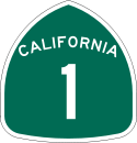 (Pacific Coast Highway)
 - Camino Las Ramblas
- Stonehill Drive
- MetrolinkMetrolink (Southern California)Metrolink is a commuter rail system serving Los Angeles and the surrounding area of Southern California; it currently consists of six lines and 55 stations using of track....
Orange County Line & AmtrakAmtrakThe National Railroad Passenger Corporation, doing business as Amtrak , is a government-owned corporation that was organized on May 1, 1971, to provide intercity passenger train service in the United States. "Amtrak" is a portmanteau of the words "America" and "track". It is headquartered at Union...
Pacific SurflinerPacific SurflinerThe Pacific Surfliner is a Amtrak regional passenger train route serving communities on the coast of Southern California between San Diego and San Luis Obispo.... - Camino Capistrano
- Interstate 5
.svg.png) (San Diego FreewaySan Diego FreewayThe San Diego Freeway is a named freeway in Southern California. It refers to the following two segments:*Interstate 5 in California, from the Mexico – United States border at the San Ysidro district of San Diego to Interstate 405 in Irvine...
(San Diego FreewaySan Diego FreewayThe San Diego Freeway is a named freeway in Southern California. It refers to the following two segments:*Interstate 5 in California, from the Mexico – United States border at the San Ysidro district of San Diego to Interstate 405 in Irvine...
)
- State Route 74California State Route 74State Route 74 , a part of the Pines to Palms Scenic Byway, is a mostly scenic highway in the U.S. state of California. It runs from Palm Desert in Riverside County westward to San Juan Capistrano in Orange County.-Route description:...
 ("Lower" Ortega Highway)
 - Antonio Parkway
- Nursery Road
- State Route 74 ("Middle" Ortega Highway)
- State Route 74 ("Upper" Ortega Highway)
See also
- List of rivers of California
- List of rivers of Orange County, California
Works cited
- Shaffer, Chris. The Definitive Guide to the Waterfalls of Southern and Central California. Shafdog Publications, 2005.