
Navarro River
Encyclopedia
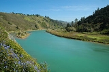
The Navarro River is a 28.3 miles (45.5 km) river
in Mendocino County, California
. It flows northwest through the Coastal Range to the Pacific Ocean
. Encompassing 315 square miles (815.8 km²), its watershed
includes the Anderson Valley
, a well-known wine-growing region in Mendocino County. The main stem of the Navarro River begins less than 1 miles (2 km) south of the town of Philo
at the confluence of Rancheria Creek and Anderson Creek. Upstream on Rancheria Creek there are 26 miles (41.8 km) of whitewater suitable for rafting and kayaking. Near Philo the river runs through Hendy Woods State Park
, a state park of more than 800 acres (323.7 ha), featuring two virgin redwood stands. Near the coast the river runs through Navarro River Redwoods State Park
. The mouth of the Navarro is 10 miles (16 km) south of the city of Mendocino
. State Route 128
starts from the intersection of State Route 1
at the mouth of the Navarro River.
was constructed at the mouth of the river in 1861. The mill was capable of cutting 35000 board feet (82.6 m³) of lumber per day by 1883. A railroad extended 14 miles (22.5 km) upriver to bring logs to the mill. The original mill burned in 1890 and a replacement bandsaw mill burned in 1902. A replacement sawmill was built near Wendling on the North Fork Navarro River and operated until September, 1927. The Wendling sawmill operation included logging railway branches along the North Fork connecting over Keen's Summit to shipping facilities at Albion
via an isolated segment of the Northwestern Pacific Railroad
. Rail service was discontinued in 1930 and the railway was dismantled for scrap in 1937.
River
A river is a natural watercourse, usually freshwater, flowing towards an ocean, a lake, a sea, or another river. In a few cases, a river simply flows into the ground or dries up completely before reaching another body of water. Small rivers may also be called by several other names, including...
in Mendocino County, California
Mendocino County, California
Mendocino County is a county located on the north coast of the U.S. state of California, north of the greater San Francisco Bay Area and west of the Central Valley. As of the 2010 census, the population was 87,841, up from 86,265 at the 2000 census...
. It flows northwest through the Coastal Range to the Pacific Ocean
Pacific Ocean
The Pacific Ocean is the largest of the Earth's oceanic divisions. It extends from the Arctic in the north to the Southern Ocean in the south, bounded by Asia and Australia in the west, and the Americas in the east.At 165.2 million square kilometres in area, this largest division of the World...
. Encompassing 315 square miles (815.8 km²), its watershed
Drainage basin
A drainage basin is an extent or an area of land where surface water from rain and melting snow or ice converges to a single point, usually the exit of the basin, where the waters join another waterbody, such as a river, lake, reservoir, estuary, wetland, sea, or ocean...
includes the Anderson Valley
Anderson Valley
Anderson Valley is a sparsely populated region in western Mendocino County in Northern California. Located approximately 100 miles north of San Francisco, the name "Anderson Valley" applies broadly to several rural, unincorporated communities in or near the alluvial terraces along Anderson Creek...
, a well-known wine-growing region in Mendocino County. The main stem of the Navarro River begins less than 1 miles (2 km) south of the town of Philo
Philo, California
Philo is a census-designated place in Mendocino County, California. It is located northwest of Boonville, at an elevation of 331 feet . The population was 349 at the 2010 census....
at the confluence of Rancheria Creek and Anderson Creek. Upstream on Rancheria Creek there are 26 miles (41.8 km) of whitewater suitable for rafting and kayaking. Near Philo the river runs through Hendy Woods State Park
Hendy Woods State Park
Hendy Woods State Park is a state park located in Mendocino County, California. The park contains two groves of old growth Coast Redwood: Big Hendy and Little Hendy . The Navarro River runs through the length of the park....
, a state park of more than 800 acres (323.7 ha), featuring two virgin redwood stands. Near the coast the river runs through Navarro River Redwoods State Park
Navarro River Redwoods State Park
Navarro River Redwoods State Park is a state park in Mendocino County, California consisting of of second-growth redwood forest in a narrow stretch long on both banks of the Navarro River, from the town of Navarro to the river's confluence with the Pacific Ocean.-Activities and facilities:The...
. The mouth of the Navarro is 10 miles (16 km) south of the city of Mendocino
Mendocino, California
Mendocino is a census-designated place in Mendocino County, California, United States. Mendocino is located south of Fort Bragg, at an elevation of 154 feet...
. State Route 128
California State Route 128
State Route 128 is a state highway in the U.S. state of California, connecting the Mendocino coast to the Central Valley through the state's Wine Country.-Route description:...
starts from the intersection of State Route 1
California State Route 1
State Route 1 , more often called Highway 1, is a state highway that runs along much of the Pacific coast of the U.S. state of California. It is famous for running along some of the most beautiful coastlines in the world, leading to its designation as an All-American Road.Highway 1 does not run...
at the mouth of the Navarro River.
History
A sawmillSawmill
A sawmill is a facility where logs are cut into boards.-Sawmill process:A sawmill's basic operation is much like those of hundreds of years ago; a log enters on one end and dimensional lumber exits on the other end....
was constructed at the mouth of the river in 1861. The mill was capable of cutting 35000 board feet (82.6 m³) of lumber per day by 1883. A railroad extended 14 miles (22.5 km) upriver to bring logs to the mill. The original mill burned in 1890 and a replacement bandsaw mill burned in 1902. A replacement sawmill was built near Wendling on the North Fork Navarro River and operated until September, 1927. The Wendling sawmill operation included logging railway branches along the North Fork connecting over Keen's Summit to shipping facilities at Albion
Albion, California
Albion is a census-designated place in Mendocino County, California. It is located south of Fort Bragg, at an elevation of 174 feet . Albion had a population of 168 at the 2010 census.-Geography:...
via an isolated segment of the Northwestern Pacific Railroad
Fort Bragg and Southeastern Railroad
The Fort Bragg and Southeastern Railroad was formed by Atchison, Topeka and Santa Fe Railway as a consolidation of logging company railways on the coast of Mendocino County, California. The line was merged into the regional Northwestern Pacific Railroad in 1907; but planned physical connection was...
. Rail service was discontinued in 1930 and the railway was dismantled for scrap in 1937.