

Falls Creek (California)
Encyclopedia
Falls Creek, also known as the Falls River, is a tributary of the Tuolumne River
in Yosemite National Park
, California
, United States
. The creek begins at the northern boundary of the national park and flows 24 miles (38.6 km) to empty into the Tuolumne at Hetch Hetchy Reservoir
, dropping over two well-known waterfalls. The Pacific Crest Trail
and other national park trails follow the creek for much of its course.
, forming two waterfalls, Wapama Falls
and Tueeulala Falls
. It is commonly assumed that Tueeulala Falls lies on a separate seasonal stream. However, according to USGS topographic maps, Tueeulala Falls lies at the mouth of a shallow canyon that Falls Creek flows into when water levels are high enough.
-shaped area stretching about 18 miles (29 km) from north to south and 2 miles (3.2 km) at its widest. The watershed shares a boundary with Frog Creek and Eleanor Creek to the west, and Tiltill and Rancheria Creek to the east. All of these creeks are tributaries of the Tuolumne River, which is in turn a tributary of the San Joaquin River
. The glaciated, mostly-granite
bowls and moraine
s of the Falls Creek watershed are home to many lakes, both named and unnamed. These include Dorothy, Mary, Tilden, Wilma, and Vernon lakes. The creek runs year round and is known to produce large amounts of runoff, often flooding bridges that carry the Hetch Hetchy trail over its mouth in the peak of snowmelt.
 Trails follow Falls Creek for much of its length. From Dorothy Pass at its headwaters to the beginning of the canyon, the Pacific Crest Trail
follows the creek southward, but breaks away to the east afterward, near Wilma Lake. From there, a spur trail continues to follow the creek southwest to the end of the canyon, where it climbs to follow the ridge to the west of the creek. Another trail leads from the west side of Hetch Hetchy Valley and climbs above the Falls Creek drainage divide with Eleanor Creek (which flows into Lake Eleanor
) and loops down to Lake Vernon. An unofficial trail also leads southwest from Lake Vernon to the brink of Wapama Falls. There are two ranger stations near Falls Creek, one at Wilma Lake and one at Lake Vernon. There are no designated campsites anywhere within the Falls Creek watershed.
Tuolumne River
The Tuolumne River is a California river that flows nearly from the central Sierra Nevada to the San Joaquin River in the Central Valley...
in Yosemite National Park
Yosemite National Park
Yosemite National Park is a United States National Park spanning eastern portions of Tuolumne, Mariposa and Madera counties in east central California, United States. The park covers an area of and reaches across the western slopes of the Sierra Nevada mountain chain...
, California
California
California is a state located on the West Coast of the United States. It is by far the most populous U.S. state, and the third-largest by land area...
, United States
United States
The United States of America is a federal constitutional republic comprising fifty states and a federal district...
. The creek begins at the northern boundary of the national park and flows 24 miles (38.6 km) to empty into the Tuolumne at Hetch Hetchy Reservoir
Hetch Hetchy Reservoir
Hetch Hetchy Reservoir is a reservoir in Yosemite National Park, about northeast from the city of Merced, California. The reservoir has a capacity of and is formed by the concrete gravity O'Shaughnessy Dam in Hetch Hetchy Valley on the Tuolumne River...
, dropping over two well-known waterfalls. The Pacific Crest Trail
Pacific Crest Trail
The Pacific Crest Trail is a long-distance mountain hiking and equestrian trail on the Western Seaboard of the United States. The southern terminus is at the California border with Mexico...
and other national park trails follow the creek for much of its course.
Course
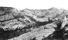
Falls Creek begins at Dorothy Lake, which is located at one of the northernmost points in the national park. The headwaters, at nearly 10000 feet (3,048 m) in elevation, lie between Forsyth Peak, Dorothy Lake Pass, Bond Pass and Bigelow Peak. It plunges into Jack Main Canyon, paralleling the Pacific Crest Trail, which carries it south to round Chittenden Peak, where Tilden Creek enters from the left. From there the creek passes Branigan Lake, then cascades down into the basin containing Lake Vernon, which it empties into. Issuing out of the southwest end of the lake, the creek flows in a southwesterly direction, approaching Hetch Hetchy Reservoir. Very near the mouth, it runs past Hetch Hetchy Dome and splits into two streams, which both cascade over the rim of Hetch Hetchy ValleyHetch Hetchy Valley
Hetch Hetchy Valley is a glacial valley in Yosemite National Park in California. It is currently completely flooded by O'Shaughnessy Dam, forming the Hetch Hetchy Reservoir. The Tuolumne River fills the reservoir. Upstream from the valley lies the Grand Canyon of the Tuolumne. The reservoir...
, forming two waterfalls, Wapama Falls
Wapama Falls
Wapama Falls is the larger of two waterfalls located on the northern wall of Hetch Hetchy Valley in Yosemite National Park. Arguably the most powerful waterfall in Yosemite National Park, it flows almost year-round and during peak flow has been known to inundate the trail bridge crossing it, making...
and Tueeulala Falls
Tueeulala Falls
Tueeulala Falls is located on the north side of Hetch Hetchy Valley in Yosemite National Park. At roughly 880 feet it is the smaller of two large waterfalls that spill into Hetch Hetchy Reservoir, the other being Wapama Falls. It is, however, the larger of the two in terms of greatest free-fall...
. It is commonly assumed that Tueeulala Falls lies on a separate seasonal stream. However, according to USGS topographic maps, Tueeulala Falls lies at the mouth of a shallow canyon that Falls Creek flows into when water levels are high enough.
Watershed
The Falls Creek watershed, though not officially measured, covers approximately 100 mi2 of the Sierra Nevada northern Yosemite National Park. It is a narrow, tildeTilde
The tilde is a grapheme with several uses. The name of the character comes from Portuguese and Spanish, from the Latin titulus meaning "title" or "superscription", though the term "tilde" has evolved and now has a different meaning in linguistics....
-shaped area stretching about 18 miles (29 km) from north to south and 2 miles (3.2 km) at its widest. The watershed shares a boundary with Frog Creek and Eleanor Creek to the west, and Tiltill and Rancheria Creek to the east. All of these creeks are tributaries of the Tuolumne River, which is in turn a tributary of the San Joaquin River
San Joaquin River
The San Joaquin River is the largest river of Central California in the United States. At over long, the river starts in the high Sierra Nevada, and flows through a rich agricultural region known as the San Joaquin Valley before reaching Suisun Bay, San Francisco Bay, and the Pacific Ocean...
. The glaciated, mostly-granite
Granite
Granite is a common and widely occurring type of intrusive, felsic, igneous rock. Granite usually has a medium- to coarse-grained texture. Occasionally some individual crystals are larger than the groundmass, in which case the texture is known as porphyritic. A granitic rock with a porphyritic...
bowls and moraine
Moraine
A moraine is any glacially formed accumulation of unconsolidated glacial debris which can occur in currently glaciated and formerly glaciated regions, such as those areas acted upon by a past glacial maximum. This debris may have been plucked off a valley floor as a glacier advanced or it may have...
s of the Falls Creek watershed are home to many lakes, both named and unnamed. These include Dorothy, Mary, Tilden, Wilma, and Vernon lakes. The creek runs year round and is known to produce large amounts of runoff, often flooding bridges that carry the Hetch Hetchy trail over its mouth in the peak of snowmelt.
Recreation
Pacific Crest Trail
The Pacific Crest Trail is a long-distance mountain hiking and equestrian trail on the Western Seaboard of the United States. The southern terminus is at the California border with Mexico...
follows the creek southward, but breaks away to the east afterward, near Wilma Lake. From there, a spur trail continues to follow the creek southwest to the end of the canyon, where it climbs to follow the ridge to the west of the creek. Another trail leads from the west side of Hetch Hetchy Valley and climbs above the Falls Creek drainage divide with Eleanor Creek (which flows into Lake Eleanor
Lake Eleanor
Lake Eleanor is a reservoir located in Yosemite National Park at an altitude of . The reservoir has a capacity of and a surface area of 953 acres...
) and loops down to Lake Vernon. An unofficial trail also leads southwest from Lake Vernon to the brink of Wapama Falls. There are two ranger stations near Falls Creek, one at Wilma Lake and one at Lake Vernon. There are no designated campsites anywhere within the Falls Creek watershed.