
Kaweah River
Encyclopedia
The Kaweah River in the U.S. state
of California flows 32 miles (51.5 km) westward from the foothills of the Sierra Nevada into the Central Valley. It rises in forks in the southern Sierra Nevada inside Sequoia National Park
, the longest of which is the Middle Fork, about 18 miles (29 km) long. Once it exits the 8000 feet (2,438.4 m)-deep canyons that make up its headwaters, the river flows into a reservoir
called Lake Kaweah
, where most of its water is stored for irrigation and flood control. Formerly the river continued southwest to empty into Tulare Lake
, the terminal sink of an endorheic basin also including the Tule
and Kern River
s as well as southern distributaries of the Kings
. Agricultural development and diversion for irrigation have left most of the Kaweah's lower course dry, as is Tulare Lake.
Snowmelt
from the high Sierra Nevada, along the 13000 feet (3,962.4 m)-high Great Western Divide
, feeds the Kaweah River, which reaches enormous peak flows in the spring and early summer and shrinks to a trickle by late autumn. The river's average flow is around 550 cuft/s, but ranges anywhere from 7500 cuft/s to 40 cuft/s in the average year. The snowmelt-season flow is about 2000 cuft/s and the summer flow is around 700 cuft/s.
The site of Lake Kaweah, in a broad, arid valley in the foothills, was once inhabited by the Yokuts people, who had permanent villages along the river but traveled into the headwaters area in summer. The name "Kaweah" is thought to mean "crow" or "raven cry" in the Yokut language. Eventually, people from the Mono Lake
basin began migrating over the Sierra Nevada, settling in the high valleys of the Kaweah's forks. Mineral King
on the East Fork of the river was the subject of a silver boom in the 1870s, which soon faded. The majority of the Kaweah drainage basin
above the Central Valley became part of Sequoia National Park in 1890, and a road was constructed along parts of the Middle Fork and the Marble Fork. The southeasternmost part of the river's watershed also became part of the park in the 1970s, after a failed proposal to build a massive ski resort
, and the Kaweah River is now a popular destination for hiking
, fishing and whitewater rafting.
, as do the Kings
, Tule
, and Kern River
s, which all begin in or near Sequoia National Park. There are five primary forks to the Kaweah River: the Middle Fork, East Fork, North Fork, South Fork and Marble Fork, ordered by size. The Middle Fork, the largest tributary and sometimes considered the main stem of the Kaweah River, rises along the Great Western Divide
, fed by a series of lakes, springs and snowfields. The river flows west, passing Moro Rock
and crossing underneath California State Route 198
, more commonly known as the Generals Highway (the main road through Sequoia National Park) between the confluence
with Paradise Creek and the Marble Fork. It receives the Marble Fork from the right, forming the Kaweah River proper, which soon receives the East Fork from the left near Three Rivers
.
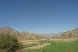
The river continues southwest to the confluence with the North Fork from the right, then the South Fork enters from the left just before Lake Kaweah
, formed by Terminus Dam
, impedes the river’s course. After passing out of the dam, the Kaweah receives Dry Creek from the right then curves south through farmland past the town of Lemon Cove
. Cottonwood Creek enters from the right and Yokohl Creek from the left. The river then splits into distributaries
, including the St. Johns River
and Deep Creek. The main channel continues southwest, joining with the Tule River
. In wet years, the river occasionally reaches the now-dry Tulare Lake bed, which even emptied into the San Joaquin River
during extreme floods through forks of the Kings River
.
there were found to be 20,000 trees (5000 of which were large trees) in the Marble Fork of the Kaweah River. There are also numerous wildflower species including the iconic Yellow Mariposa Lily, Calochortus luteus
, which has been specifically noted in the Lime Kiln Creek tributary watershed
. The Kaweah River is famous for its stands of giant sequoias, which were one of the reasons for the establishment of the national park. The giant sequoia are native to the western slopes of the Sierra Nevada, and they are especially abundant in the South Sierra, where the Kaweah River flows.
The meaning of the word "kaweah", pronounced "ga-we-hah", in the ancient Yokuts language is "crow" or "raven cry".
The first inhabitants of the Kaweah River Watershed were the Yokuts, who claimed water rights to the entire river. They settled in several villages in the broad, arid valley the Kaweah cuts through the foothills
of the Sierra Nevada, in and around the present-day site of Lake Kaweah
, an irrigation and water supply lake. The Yokut sub-tribe called the Wukchumni lived in this area; their largest villages included Cobble Lodge at the confluence of the Kaweah River and Horse Creek (a southern tributary), and Slick Rock Village further upstream. Lower on the river were the Fawia, Telamni, Wolasi, Choinok, and Yokod. Further north, in the Kings River
watershed, were the Monachi.
Subsisting mostly on acorn
s, the Yokut ground acorns in mortar
s with granite
pestles, and creating cakes and other foods from the material.They claimed the water rights of the entire Kaweah although in time, tribes from the Mono Basin
east of the Sierra Nevada came over the Sierra and settled in the high mountain valleys of the Kaweah. Mineral King
, a valley on the East Fork Kaweah River, was a summer settlement for the Yokut. However, several years before the arrival of Europeans, the valley became taboo to them for an unknown reason.
Spanish explorers named the river Rio San Francisco and Rio San Gabriel while early American settlers often referred to the river as the River Francis.
The first known European settler along the Kaweah river was Hale Dixon Tharp
in 1856. He settled on Horse Creek near its confluence with the Kaweah River. During the 1860s, other stockman settled along the various forks of the river claiming large areas of land under the Homestead Act of 1862. This act allowed a settler to occupy 160 acre (0.6474976 km²), or 320 acres (1.3 km²) for a man and wife together. Thus began the settlement of the Kaweah region. Since then, various mining towns (due to the discovery of silver) and small establishments have existed in the area.
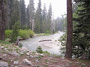
on the river, but access is difficult because some of the land is privately-owned, particularly in the lower portion. There are several companies that offer day trips on the class IV section. The Kaweah River is free-flowing above Lake Kaweah and depending on the winter snowfall, it can rise to very high flows during the spring. It is best if rafters and kayakers have previous experience running class IV because with the fluctuating flows, the river requires great maneuvering and whitewater skills.
U.S. state
A U.S. state is any one of the 50 federated states of the United States of America that share sovereignty with the federal government. Because of this shared sovereignty, an American is a citizen both of the federal entity and of his or her state of domicile. Four states use the official title of...
of California flows 32 miles (51.5 km) westward from the foothills of the Sierra Nevada into the Central Valley. It rises in forks in the southern Sierra Nevada inside Sequoia National Park
Sequoia National Park
Sequoia National Park is a national park in the southern Sierra Nevada east of Visalia, California, in the United States. It was established on September 25, 1890. The park spans . Encompassing a vertical relief of nearly , the park contains among its natural resources the highest point in the...
, the longest of which is the Middle Fork, about 18 miles (29 km) long. Once it exits the 8000 feet (2,438.4 m)-deep canyons that make up its headwaters, the river flows into a reservoir
Reservoir
A reservoir , artificial lake or dam is used to store water.Reservoirs may be created in river valleys by the construction of a dam or may be built by excavation in the ground or by conventional construction techniques such as brickwork or cast concrete.The term reservoir may also be used to...
called Lake Kaweah
Lake Kaweah
Lake Kaweah is a reservoir near Lemon Cove in Tulare County, California. The lake is formed by Terminus Dam on the Kaweah River. The river originates in the Sierra Nevada mountains and drains about into Lake Kaweah. From Lake Kaweah, the river passes near the city of Visalia as it flows west into...
, where most of its water is stored for irrigation and flood control. Formerly the river continued southwest to empty into Tulare Lake
Tulare Lake
Tulare Lake, named Laguna de Tache by the Spanish, is a fresh-water dry lake with residual wetlands and marshes in southern San Joaquin Valley, California...
, the terminal sink of an endorheic basin also including the Tule
Tule River
The Tule River, also called Rio de San Pedro or Rio San Pedro, is a river in Tulare County in the U.S. state of California. The river originates in the Sierra Nevada east of Porterville and consists of three forks, North, Middle and South. The North Fork and Middle Fork meet above Springville. The...
and Kern River
Kern River
The Kern River is a river in the U.S. state of California, approximately long. It drains an area of the southern Sierra Nevada mountains northeast of Bakersfield. Fed by snowmelt near Mount Whitney, the river passes through scenic canyons in the mountains and is a popular destination for...
s as well as southern distributaries of the Kings
Kings River (California)
The Kings River is a major river of south-central California. About long, it drains an area of the high western Sierra Nevada and the Central Valley. A large alluvial fan has formed where the river's gradient decreases in the Central Valley so the river divides into distributaries...
. Agricultural development and diversion for irrigation have left most of the Kaweah's lower course dry, as is Tulare Lake.
Snowmelt
Snowmelt
In hydrology, snowmelt is surface runoff produced from melting snow. It can also be used to describe the period or season during which such runoff is produced. Water produced by snowmelt is an important part of the annual water cycle in many parts of the world, in some cases contributing high...
from the high Sierra Nevada, along the 13000 feet (3,962.4 m)-high Great Western Divide
Great Western Divide
The Great Western Divide is a Sierra Nevada mountain range that forms part of the border between the Kings Canyon and Sequoia National Parks. The High Sierra Trail crosses the range at Kaweah Gap from Sequoia National Park.- References :...
, feeds the Kaweah River, which reaches enormous peak flows in the spring and early summer and shrinks to a trickle by late autumn. The river's average flow is around 550 cuft/s, but ranges anywhere from 7500 cuft/s to 40 cuft/s in the average year. The snowmelt-season flow is about 2000 cuft/s and the summer flow is around 700 cuft/s.
The site of Lake Kaweah, in a broad, arid valley in the foothills, was once inhabited by the Yokuts people, who had permanent villages along the river but traveled into the headwaters area in summer. The name "Kaweah" is thought to mean "crow" or "raven cry" in the Yokut language. Eventually, people from the Mono Lake
Mono Lake
Mono Lake is a large, shallow saline lake in Mono County, California, formed at least 760,000 years ago as a terminal lake in a basin that has no outlet to the ocean...
basin began migrating over the Sierra Nevada, settling in the high valleys of the Kaweah's forks. Mineral King
Mineral King
Mineral King is a subalpine glacial valley located in the southern part of Sequoia National Park, in the U.S. state of California. The valley lies at the headwaters of the East Fork of the Kaweah River, which rises at the eastern part of the valley and flows northwest...
on the East Fork of the river was the subject of a silver boom in the 1870s, which soon faded. The majority of the Kaweah drainage basin
Drainage basin
A drainage basin is an extent or an area of land where surface water from rain and melting snow or ice converges to a single point, usually the exit of the basin, where the waters join another waterbody, such as a river, lake, reservoir, estuary, wetland, sea, or ocean...
above the Central Valley became part of Sequoia National Park in 1890, and a road was constructed along parts of the Middle Fork and the Marble Fork. The southeasternmost part of the river's watershed also became part of the park in the 1970s, after a failed proposal to build a massive ski resort
Ski resort
A ski resort is a resort developed for skiing and other winter sports. In Europe a ski resort is a town or village in a ski area - a mountainous area, where there are ski trails and supporting services such as hotels and other accommodation, restaurants, equipment rental and a ski lift system...
, and the Kaweah River is now a popular destination for hiking
Hiking
Hiking is an outdoor activity which consists of walking in natural environments, often in mountainous or other scenic terrain. People often hike on hiking trails. It is such a popular activity that there are numerous hiking organizations worldwide. The health benefits of different types of hiking...
, fishing and whitewater rafting.
Course
The Kaweah River rises in the southernmost part of the Sierra Nevada and flows southwest into the dry endorheic basin of the southern San Joaquin ValleySan Joaquin Valley
The San Joaquin Valley is the area of the Central Valley of California that lies south of the Sacramento – San Joaquin River Delta in Stockton...
, as do the Kings
Kings River (California)
The Kings River is a major river of south-central California. About long, it drains an area of the high western Sierra Nevada and the Central Valley. A large alluvial fan has formed where the river's gradient decreases in the Central Valley so the river divides into distributaries...
, Tule
Tule River
The Tule River, also called Rio de San Pedro or Rio San Pedro, is a river in Tulare County in the U.S. state of California. The river originates in the Sierra Nevada east of Porterville and consists of three forks, North, Middle and South. The North Fork and Middle Fork meet above Springville. The...
, and Kern River
Kern River
The Kern River is a river in the U.S. state of California, approximately long. It drains an area of the southern Sierra Nevada mountains northeast of Bakersfield. Fed by snowmelt near Mount Whitney, the river passes through scenic canyons in the mountains and is a popular destination for...
s, which all begin in or near Sequoia National Park. There are five primary forks to the Kaweah River: the Middle Fork, East Fork, North Fork, South Fork and Marble Fork, ordered by size. The Middle Fork, the largest tributary and sometimes considered the main stem of the Kaweah River, rises along the Great Western Divide
Great Western Divide
The Great Western Divide is a Sierra Nevada mountain range that forms part of the border between the Kings Canyon and Sequoia National Parks. The High Sierra Trail crosses the range at Kaweah Gap from Sequoia National Park.- References :...
, fed by a series of lakes, springs and snowfields. The river flows west, passing Moro Rock
Moro Rock
Moro Rock is a granite dome rock formation in Sequoia National Park, California, USA. It is located in the center of the park, at the head of Moro Creek, between Giant Forest and Crescent Meadow. A stairway, built in the 1930s by the Civilian Conservation Corps, is cut into and poured onto the...
and crossing underneath California State Route 198
California State Route 198
State Route 198 is an east–west state highway that connects the California Central Coast to the mid-Central Valley at Visalia, although the most-traveled portion is in the Central Valley itself....
, more commonly known as the Generals Highway (the main road through Sequoia National Park) between the confluence
Confluence
Confluence, in geography, describes the meeting of two or more bodies of water.Confluence may also refer to:* Confluence , a property of term rewriting systems...
with Paradise Creek and the Marble Fork. It receives the Marble Fork from the right, forming the Kaweah River proper, which soon receives the East Fork from the left near Three Rivers
Three Rivers, California
Three Rivers is a census-designated place in Tulare County, California, United States. The population was 2,182 at the 2010 census, down from 2,248 at the 2000 census....
.
The river continues southwest to the confluence with the North Fork from the right, then the South Fork enters from the left just before Lake Kaweah
Lake Kaweah
Lake Kaweah is a reservoir near Lemon Cove in Tulare County, California. The lake is formed by Terminus Dam on the Kaweah River. The river originates in the Sierra Nevada mountains and drains about into Lake Kaweah. From Lake Kaweah, the river passes near the city of Visalia as it flows west into...
, formed by Terminus Dam
Terminus Dam
Terminus Dam is a dam on the Kaweah River, which serves to form Lake Kaweah.The dam provides irrigation and municipal water supply, and as a result, the Kaweah River below the dam is usually regulated for a stable flow year round. The South Fork and the mainstem of the Kaweah both flow into the...
, impedes the river’s course. After passing out of the dam, the Kaweah receives Dry Creek from the right then curves south through farmland past the town of Lemon Cove
Lemon Cove, California
Lemon Cove is a census-designated place in Tulare County, California, United States. The population was 308 at the 2010 census, up from 298 at the 2000 census.-Geography and ecology:...
. Cottonwood Creek enters from the right and Yokohl Creek from the left. The river then splits into distributaries
Distributary
A distributary, or a distributary channel, is a stream that branches off and flows away from a main stream channel. They are a common feature of river deltas. The phenomenon is known as river bifurcation. The opposite of a distributary is a tributary...
, including the St. Johns River
St. Johns River
The St. Johns River is the longest river in the U.S. state of Florida and its most significant for commercial and recreational use. At long, it winds through or borders twelve counties, three of which are the state's largest. The drop in elevation from the headwaters to the mouth is less than ;...
and Deep Creek. The main channel continues southwest, joining with the Tule River
Tule River
The Tule River, also called Rio de San Pedro or Rio San Pedro, is a river in Tulare County in the U.S. state of California. The river originates in the Sierra Nevada east of Porterville and consists of three forks, North, Middle and South. The North Fork and Middle Fork meet above Springville. The...
. In wet years, the river occasionally reaches the now-dry Tulare Lake bed, which even emptied into the San Joaquin River
San Joaquin River
The San Joaquin River is the largest river of Central California in the United States. At over long, the river starts in the high Sierra Nevada, and flows through a rich agricultural region known as the San Joaquin Valley before reaching Suisun Bay, San Francisco Bay, and the Pacific Ocean...
during extreme floods through forks of the Kings River
Kings River (California)
The Kings River is a major river of south-central California. About long, it drains an area of the high western Sierra Nevada and the Central Valley. A large alluvial fan has formed where the river's gradient decreases in the Central Valley so the river divides into distributaries...
.
Natural history
The watershed has numerous flora and fauna species, with considerable forested reaches. In the 1909 survey by Willis Linn JepsonWillis Linn Jepson
Willis Linn Jepson is known as California's most distinguished early botanist. He became interested in botany as a boy and explored adjacent regions. He had come in contact with various botanists before he entered college...
there were found to be 20,000 trees (5000 of which were large trees) in the Marble Fork of the Kaweah River. There are also numerous wildflower species including the iconic Yellow Mariposa Lily, Calochortus luteus
Calochortus luteus
Calochortus luteus, or Yellow mariposa lily, is a mariposa lily endemic to California.-Description:The primarily a bright deep yellow flower is 3-5cm across and perianth Bulb-shaped, lined red-brown inside, often also with central red-brown blotch and sparse hair inside.-Distribution:This species...
, which has been specifically noted in the Lime Kiln Creek tributary watershed
Drainage basin
A drainage basin is an extent or an area of land where surface water from rain and melting snow or ice converges to a single point, usually the exit of the basin, where the waters join another waterbody, such as a river, lake, reservoir, estuary, wetland, sea, or ocean...
. The Kaweah River is famous for its stands of giant sequoias, which were one of the reasons for the establishment of the national park. The giant sequoia are native to the western slopes of the Sierra Nevada, and they are especially abundant in the South Sierra, where the Kaweah River flows.
History
The meaning of the word "kaweah", pronounced "ga-we-hah", in the ancient Yokuts language is "crow" or "raven cry".
The first inhabitants of the Kaweah River Watershed were the Yokuts, who claimed water rights to the entire river. They settled in several villages in the broad, arid valley the Kaweah cuts through the foothills
Foothills
Foothills are geographically defined as gradual increases in elevation at the base of a mountain range. They are a transition zone between plains and low relief hills to the adjacent topographically high mountains.-Examples:...
of the Sierra Nevada, in and around the present-day site of Lake Kaweah
Lake Kaweah
Lake Kaweah is a reservoir near Lemon Cove in Tulare County, California. The lake is formed by Terminus Dam on the Kaweah River. The river originates in the Sierra Nevada mountains and drains about into Lake Kaweah. From Lake Kaweah, the river passes near the city of Visalia as it flows west into...
, an irrigation and water supply lake. The Yokut sub-tribe called the Wukchumni lived in this area; their largest villages included Cobble Lodge at the confluence of the Kaweah River and Horse Creek (a southern tributary), and Slick Rock Village further upstream. Lower on the river were the Fawia, Telamni, Wolasi, Choinok, and Yokod. Further north, in the Kings River
Kings River (California)
The Kings River is a major river of south-central California. About long, it drains an area of the high western Sierra Nevada and the Central Valley. A large alluvial fan has formed where the river's gradient decreases in the Central Valley so the river divides into distributaries...
watershed, were the Monachi.
Subsisting mostly on acorn
Acorn
The acorn, or oak nut, is the nut of the oaks and their close relatives . It usually contains a single seed , enclosed in a tough, leathery shell, and borne in a cup-shaped cupule. Acorns vary from 1–6 cm long and 0.8–4 cm broad...
s, the Yokut ground acorns in mortar
Mortar and pestle
A mortar and pestle is a tool used to crush, grind, and mix solid substances . The pestle is a heavy bat-shaped object, the end of which is used for crushing and grinding. The mortar is a bowl, typically made of hard wood, ceramic or stone...
s with granite
Granite
Granite is a common and widely occurring type of intrusive, felsic, igneous rock. Granite usually has a medium- to coarse-grained texture. Occasionally some individual crystals are larger than the groundmass, in which case the texture is known as porphyritic. A granitic rock with a porphyritic...
pestles, and creating cakes and other foods from the material.They claimed the water rights of the entire Kaweah although in time, tribes from the Mono Basin
Mono Lake
Mono Lake is a large, shallow saline lake in Mono County, California, formed at least 760,000 years ago as a terminal lake in a basin that has no outlet to the ocean...
east of the Sierra Nevada came over the Sierra and settled in the high mountain valleys of the Kaweah. Mineral King
Mineral King
Mineral King is a subalpine glacial valley located in the southern part of Sequoia National Park, in the U.S. state of California. The valley lies at the headwaters of the East Fork of the Kaweah River, which rises at the eastern part of the valley and flows northwest...
, a valley on the East Fork Kaweah River, was a summer settlement for the Yokut. However, several years before the arrival of Europeans, the valley became taboo to them for an unknown reason.
Spanish explorers named the river Rio San Francisco and Rio San Gabriel while early American settlers often referred to the river as the River Francis.
The first known European settler along the Kaweah river was Hale Dixon Tharp
Hale Tharp
Hale Dixon Tharp was a miner during the California Gold Rush, and the first non-Native American to enter Giant Forest, in what is now Sequoia National Park.-Gold Country:...
in 1856. He settled on Horse Creek near its confluence with the Kaweah River. During the 1860s, other stockman settled along the various forks of the river claiming large areas of land under the Homestead Act of 1862. This act allowed a settler to occupy 160 acre (0.6474976 km²), or 320 acres (1.3 km²) for a man and wife together. Thus began the settlement of the Kaweah region. Since then, various mining towns (due to the discovery of silver) and small establishments have existed in the area.
Recreation
There is some fishing and raftingRafting
Rafting or white water rafting is a challenging recreational outdoor activity using an inflatable raft to navigate a river or other bodies of water. This is usually done on white water or different degrees of rough water, in order to thrill and excite the raft passengers. The development of this...
on the river, but access is difficult because some of the land is privately-owned, particularly in the lower portion. There are several companies that offer day trips on the class IV section. The Kaweah River is free-flowing above Lake Kaweah and depending on the winter snowfall, it can rise to very high flows during the spring. It is best if rafters and kayakers have previous experience running class IV because with the fluctuating flows, the river requires great maneuvering and whitewater skills.