

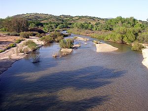
San Antonio River (California)
Encyclopedia
River
A river is a natural watercourse, usually freshwater, flowing towards an ocean, a lake, a sea, or another river. In a few cases, a river simply flows into the ground or dries up completely before reaching another body of water. Small rivers may also be called by several other names, including...
in southern Monterey County, California
Monterey County, California
Monterey County is a county located on the Pacific coast of the U.S. state of California, its northwestern section forming the southern half of Monterey Bay. The northern half of the bay is in Santa Cruz County. As of 2010, the population was 415,057. The county seat and largest city is Salinas...
.
Geography
The river travels southeast from its headwaters in the Santa Lucia Range in the Los Padres National ForestLos Padres National Forest
Los Padres National Forest is a forest located in southern and central California, which includes most of the mountainous land along the California coast from Ventura to Monterey, extending inland...
and into Lake San Antonio
Lake San Antonio
Lake San Antonio is a lake in southern Monterey County, California. The lake is formed by an earthfill dam on the San Antonio River. The dam is 202 feet tall and was completed in 1965 under Monterey County District Engineer Loran Bunte Jr . The lake and dam are owned by the Monterey County Water...
. This is a reservoir
Reservoir
A reservoir , artificial lake or dam is used to store water.Reservoirs may be created in river valleys by the construction of a dam or may be built by excavation in the ground or by conventional construction techniques such as brickwork or cast concrete.The term reservoir may also be used to...
behind the San Antonio Dam, an earth-fill dam
Dam
A dam is a barrier that impounds water or underground streams. Dams generally serve the primary purpose of retaining water, while other structures such as floodgates or levees are used to manage or prevent water flow into specific land regions. Hydropower and pumped-storage hydroelectricity are...
on the river that forms the largest lake in the county. Downstream from the dam, the river travels east until it joins the Salinas River
Salinas River (California)
The Salinas River is the largest river of the central coast of California, running and draining 4,160 square miles. It flows north-northwest and drains the Salinas Valley that slices through the Coast Range south from Monterey Bay...
.
The Nacimiento River
Nacimiento River
The Nacimiento River is a river in southern Monterey County and northern San Luis Obispo County, California. A large portion of the river's run is on military reservations...
, which feeds Lake Nacimiento
Lake Nacimiento
Lake Nacimiento is an long lake on the Nacimiento River in northern San Luis Obispo County, California. The lake contains many arms including Snake Creek and Dip Creek, nearer the dam, and the central Las Tablas and Franklin Creeks. Because of the dragon-like shape created by the positions of...
and is also a Salinas River tributary, and mirrors the San Antonio River's path several miles to the southwest.
Ecology
After depletion by 19th century fur trappers, California golden beaver (Castor canadensis subauratus) have expanded their range from the San Antonio River below the reservoir to the Salinas RiverSalinas River (California)
The Salinas River is the largest river of the central coast of California, running and draining 4,160 square miles. It flows north-northwest and drains the Salinas Valley that slices through the Coast Range south from Monterey Bay...
mainstem.