
Gualala River
Encyclopedia
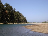
The Gualala River is a river
on the northern coast of California
. Most of the river is in Sonoma County
, but a portion is in Mendocino County
. The headwaters of the 40 miles (64.4 km) river (measuring via its South Fork) are high in the Coast Range, and it empties into the Pacific Ocean
. For its last few miles, it forms the boundary between Sonoma County and Mendocino County.
The river has three forks: the South Fork, Wheatfield Fork
and the North Fork. The South Fork is the longest and travels northwest, parallel to the coast. The Wheatfield Fork begins west of Lake Sonoma
and has the largest flow of the three forks. Its tributaries include Tombs, Wolf, House, Haupt and Fuller creeks. Wheatfield is the first fork to combine with the South Fork. Buckeye Creek, a tributary of the river, joins the South Fork next. It is followed by Rockpile Creek and Big Pepperwod Creek. The North Fork is the only part of the river in Mendocino County. It travels roughly southwest towards the coast and meets the South Fork at the border between the counties, a few miles before the river flows into the ocean.
The mountainous watershed has an area of about 298 square miles (771.8 km²), three quarters of it in Sonoma County and one quarter in Mendocino County. Rainfall varies from 38 inches (96.5 cm) per year at the coast to 70 inches (177.8 cm) inland. The watershed is sparsely populated. Timber
production is the predominant land use, historically and currently. Grazing
was previously important but has become less prevalent.
The most important problem for the watershed is excessive erosion
. The area has a high degree of natural erosion because of uplift and displacement caused by the San Andreas Fault
, which runs through the area. However, logging
and roads have greatly increased the amount of sediment
ation in the river. Kelly Road, which runs between Lake Sonoma and Annapolis
, is a major source of sediment in the river and its tributaries. High water temperatures is another significant problem. Logging has removed large streamside tree
s that provided shade and reduced the amount of large woody debris, which creates pools.
In 2002, Alaska businessmen and former Reagan administration
Interior Department official Ric Davidge announced plans to collect water from the Albion
and Gualala rivers in large bags and tow it several hundred miles south to San Diego as drinking water. However, the plan drew local opposition, and was eventually shelved after the state government passed new laws requiring extensive studies of the effects on fish habitats before any such plan could proceed. The governor later signed a law declaring the two rivers as recreational areas, preventing similar attempts at exploiting their resources.
River
A river is a natural watercourse, usually freshwater, flowing towards an ocean, a lake, a sea, or another river. In a few cases, a river simply flows into the ground or dries up completely before reaching another body of water. Small rivers may also be called by several other names, including...
on the northern coast of California
California
California is a state located on the West Coast of the United States. It is by far the most populous U.S. state, and the third-largest by land area...
. Most of the river is in Sonoma County
Sonoma County, California
Sonoma County, located on the northern coast of the U.S. state of California, is the largest and northernmost of the nine San Francisco Bay Area counties. Its population at the 2010 census was 483,878. Its largest city and county seat is Santa Rosa....
, but a portion is in Mendocino County
Mendocino County, California
Mendocino County is a county located on the north coast of the U.S. state of California, north of the greater San Francisco Bay Area and west of the Central Valley. As of the 2010 census, the population was 87,841, up from 86,265 at the 2000 census...
. The headwaters of the 40 miles (64.4 km) river (measuring via its South Fork) are high in the Coast Range, and it empties into the Pacific Ocean
Pacific Ocean
The Pacific Ocean is the largest of the Earth's oceanic divisions. It extends from the Arctic in the north to the Southern Ocean in the south, bounded by Asia and Australia in the west, and the Americas in the east.At 165.2 million square kilometres in area, this largest division of the World...
. For its last few miles, it forms the boundary between Sonoma County and Mendocino County.
The river has three forks: the South Fork, Wheatfield Fork
Wheatfield Fork Gualala River
The Wheatfield Fork Gualala River is a stream in the mountains of western Sonoma County, California which empties into the South Fork Gualala River just east of Sea Ranch, California.-Course:Tributaries include:*Fuller Creek*Haupt Creek*Tobacco Creek...
and the North Fork. The South Fork is the longest and travels northwest, parallel to the coast. The Wheatfield Fork begins west of Lake Sonoma
Lake Sonoma
Lake Sonoma is a reservoir west of Healdsburg in northern Sonoma County, California, U.S.A., created by the construction of Warm Springs Dam. Access from U.S. Route 101 is by way of Dry Creek Road from Healdsburg....
and has the largest flow of the three forks. Its tributaries include Tombs, Wolf, House, Haupt and Fuller creeks. Wheatfield is the first fork to combine with the South Fork. Buckeye Creek, a tributary of the river, joins the South Fork next. It is followed by Rockpile Creek and Big Pepperwod Creek. The North Fork is the only part of the river in Mendocino County. It travels roughly southwest towards the coast and meets the South Fork at the border between the counties, a few miles before the river flows into the ocean.
The mountainous watershed has an area of about 298 square miles (771.8 km²), three quarters of it in Sonoma County and one quarter in Mendocino County. Rainfall varies from 38 inches (96.5 cm) per year at the coast to 70 inches (177.8 cm) inland. The watershed is sparsely populated. Timber
Timber
Timber may refer to:* Timber, a term common in the United Kingdom and Australia for wood materials * Timber, Oregon, an unincorporated community in the U.S...
production is the predominant land use, historically and currently. Grazing
Grazing
Grazing generally describes a type of feeding, in which a herbivore feeds on plants , and also on other multicellular autotrophs...
was previously important but has become less prevalent.
The most important problem for the watershed is excessive erosion
Erosion
Erosion is when materials are removed from the surface and changed into something else. It only works by hydraulic actions and transport of solids in the natural environment, and leads to the deposition of these materials elsewhere...
. The area has a high degree of natural erosion because of uplift and displacement caused by the San Andreas Fault
San Andreas Fault
The San Andreas Fault is a continental strike-slip fault that runs a length of roughly through California in the United States. The fault's motion is right-lateral strike-slip...
, which runs through the area. However, logging
Logging
Logging is the cutting, skidding, on-site processing, and loading of trees or logs onto trucks.In forestry, the term logging is sometimes used in a narrow sense concerning the logistics of moving wood from the stump to somewhere outside the forest, usually a sawmill or a lumber yard...
and roads have greatly increased the amount of sediment
Sediment
Sediment is naturally occurring material that is broken down by processes of weathering and erosion, and is subsequently transported by the action of fluids such as wind, water, or ice, and/or by the force of gravity acting on the particle itself....
ation in the river. Kelly Road, which runs between Lake Sonoma and Annapolis
Annapolis, California
Annapolis is an unincorporated community in Sonoma County, California, United States. Annapolis is north-northeast of Stewarts Point. Annapolis has a post office with ZIP code 95412, which was established in 1901. The community is named after Annapolis Orchards, which was founded in the area in...
, is a major source of sediment in the river and its tributaries. High water temperatures is another significant problem. Logging has removed large streamside tree
Tree
A tree is a perennial woody plant. It is most often defined as a woody plant that has many secondary branches supported clear of the ground on a single main stem or trunk with clear apical dominance. A minimum height specification at maturity is cited by some authors, varying from 3 m to...
s that provided shade and reduced the amount of large woody debris, which creates pools.
In 2002, Alaska businessmen and former Reagan administration
Reagan Administration
The United States presidency of Ronald Reagan, also known as the Reagan administration, was a Republican administration headed by Ronald Reagan from January 20, 1981, to January 20, 1989....
Interior Department official Ric Davidge announced plans to collect water from the Albion
Albion River
The Albion River is an river in Mendocino County, California. The river drains about on the Mendocino Coast and empties into the Pacific Ocean near the town of Albion, California, where California State Route 1 crosses it on the Albion River Bridge. The river's overall direction is east to west,...
and Gualala rivers in large bags and tow it several hundred miles south to San Diego as drinking water. However, the plan drew local opposition, and was eventually shelved after the state government passed new laws requiring extensive studies of the effects on fish habitats before any such plan could proceed. The governor later signed a law declaring the two rivers as recreational areas, preventing similar attempts at exploiting their resources.
See also
- Gualala Point Regional ParkGualala Point Regional ParkGualala Point Regional Park is a regional park on Gualala Point at the mouth of the Gualala River in Sonoma County, California, south of the Gualala. The park is maintained by the Sonoma County Regional Parks Department...
- List of rivers in California
- List of watercourses in the San Francisco Bay Area