
Oso Creek
Encyclopedia
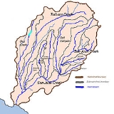
Oso Creek is an approximately 13.5 miles (21.7 km) tributary of Trabuco Creek
in southern Orange County
in the U.S. state
of California
. Draining about 20 mi2 in a region north of the San Joaquin Hills
and south of the Santa Ana Mountains
, the creek is Trabuco Creek's largest tributary, and is part of the San Juan Creek
drainage basin. Beginning in the foothills of the Santa Ana Mountains near the city of Mission Viejo
, the creek is dammed twice to form Upper Oso Reservoir and Lake Mission Viejo
. The creek is channelized and polluted along much of its length.
"Oso", meaning bear
in the Spanish language
, was likely the name given to the creek by Spanish conquistador
s. Up to the 1970s, the Oso Creek watershed was mostly undeveloped and the creek ephemeral
. The watershed lies close to two major wilderness areas - Aliso and Wood Canyons Regional Park to the southwest and O'Neill Regional Park to the west, on Trabuco Creek - but has no major parks within its boundaries. Interstate 5
parallels the creek for over half of its length.
and for the next mile (1.6 km) of its course, it flows through a narrow riparian corridor surrounded by residential areas in the city of Mission Viejo. The creek enters an underground culvert
, bends east and south, and enters Lake Mission Viejo
, 12 miles (19.3 km) from the mouth.
Downstream of the artificial lake, Oso Creek flows through a golf course
, then after flowing through another narrow canyon, receives an unnamed tributary from the left, 10.5 miles (16.9 km) from the mouth. It then bends slightly to flow southwest and enters a culvert under Marguerite Parkway, emptying into another golf course, 8 miles (12.9 km) from the mouth. The creek then crosses under Interstate 5
and flows between the highway and Camino Capistrano through a series of freshwater marshes. The La Paz Channel, its largest tributary, joins here on the right. It passes the Galivan Basin, which functions to capture floodwaters from Oso Creek, on the right bank, and receives from the right a second unnamed tributary, 7.5 miles (12.1 km) from the mouth. This tributary actually flows through the Galivan Basin before meeting Oso Creek.
The creek then bends southwest around several shopping centers near the convergence of Interstate 5 and California State Route 73
, within the city limits of Laguna Niguel
. Near this area, Oso Creek enters a concrete flood control channel
with sloping sides, 5 miles (8 km) from the mouth. It then flows through a riprap
lined channel before entering a concrete box culvert, which runs south under the state route. The creek then spills out into a natural channel, 1.2 miles (1.9 km) from the mouth, which it has incised to depths of 50 feet (15.2 m) or more, as the interstate bends southeast. Flowing through an agricultural area, the creek bends east to join Trabuco Creek inside San Juan Capistrano.
, Laguna Niguel
, and San Juan Capistrano. Most of the watershed is used for residential, commercial, and agricultural purposes. Oso Creek runs parallel to Trabuco Creek, while Salt Creek is to the southwest, Sulphur Creek
to the west, and Aliso Creek to the northwest.
The southernmost portions of the San Joaquin Hills
lie to the west and southwest of the Oso Creek watershed, and the Santa Ana Mountains
border it to the north and northeast. The drainage divide between Oso Creek and the Aliso Creek watershed is quite pronounced, connecting the San Joaquin Hills to the Santa Ana Mountains in a northeasterly direction.
, but significant amounts of urban runoff
that flow uncontrolled into the creek have created a perennial flow, known also as a "nuisance flow". This dry-season flow, which has an average minimum of 1 cuft/s, has created erosion problems in the few unlined reaches of the creek, as the creek is mostly channelized. A structure exists on Oso Creek that is designed to divert a portion of the flow into the Galivan Basin depending on the specific level of a high inflow. Amounts diverted include 350 cuft/s during a flow of 4000 cuft/s, and 4800 cuft/s during a flow of 29000 cuft/s.
along Oso Creek, due to upstream development, had carved a 50 feet (15.2 m) deep canyon from a creek channel that originally "was about 6 feet deep and 6 feet wide". The canyon was threatening to swallow large portions of citrus
groves. It begins less than 1 miles (1.6 km) downstream of the Interstate 5
/California State Route 73
interchange, where Oso Creek spills out of its concrete channel onto bare ground, and continues downstream to where the creek meets Trabuco Creek.
In early 1993, severe storm erosion damage along Oso Creek threatened sewer lines and a church. On 15 March 2000, 21,000 U.S. gallons (80 m3) overflowed into Oso Creek from a broken sewage pipeline in Mission Viejo.
, specifically near the Crown Valley Parkway crossing, approximately 5 miles (8 km) above the confluence with Trabuco Creek and in total 8 miles (12.9 km) above where the water joins San Juan. This gauge recorded a peak flow of 5150 cuft/s on 16 February 1980, with gauge height 7.6 feet (2.3 m). The second highest flow was the preceding year, which saw a flow of 2445 cuft/s, roughly half that of the highest recorded flow.
Trabuco Creek
Trabuco Creek is a small river in the U.S. state of California, flowing from the westernmost extreme of Riverside County through Orange County to join San Juan Creek in the city of San Juan Capistrano. long, its watershed covers in southeastern Orange County, including portions of three...
in southern Orange County
Orange County, California
Orange County is a county in the U.S. state of California. Its county seat is Santa Ana. As of the 2010 census, its population was 3,010,232, up from 2,846,293 at the 2000 census, making it the third most populous county in California, behind Los Angeles County and San Diego County...
in the U.S. state
U.S. state
A U.S. state is any one of the 50 federated states of the United States of America that share sovereignty with the federal government. Because of this shared sovereignty, an American is a citizen both of the federal entity and of his or her state of domicile. Four states use the official title of...
of California
California
California is a state located on the West Coast of the United States. It is by far the most populous U.S. state, and the third-largest by land area...
. Draining about 20 mi2 in a region north of the San Joaquin Hills
San Joaquin Hills
The San Joaquin Hills are a set of low hills in coastal Orange County, California. They extend in a northwest-southeast direction, starting in the northwest in Newport Beach at the southern edge of the Los Angeles Basin, and extending southeast to San Juan Capistrano.-Geography and habitats:Named...
and south of the Santa Ana Mountains
Santa Ana Mountains
The Santa Ana Mountains are a short peninsular mountain range along the coast of Southern California in the United States. They extend for approximately 36 mi southeast of the Los Angeles Basin largely along the border between Orange and Riverside counties.- Geography :The range starts in the...
, the creek is Trabuco Creek's largest tributary, and is part of the San Juan Creek
San Juan Creek
San Juan Creek, also called the San Juan River, is a stream in Orange County, California that consists of a catchment basin encompassing . Its mainstem rises in the Santa Ana Mountains, in the Trabuco Ranger District of the Cleveland National Forest...
drainage basin. Beginning in the foothills of the Santa Ana Mountains near the city of Mission Viejo
Mission Viejo, California
Mission Viejo is a city located in southern Orange County, California, U.S. in the Saddleback Valley. Mission Viejo is considered one of the largest master-planned communities ever built under a single project in the United States, and is rivaled only by Highlands Ranch, Colorado, in its size...
, the creek is dammed twice to form Upper Oso Reservoir and Lake Mission Viejo
Lake Mission Viejo
Lake Mission Viejo is a reservoir entirely within Mission Viejo, in Orange County in the U.S. state of California. About south of Santiago Peak, a peak in the Santa Ana Mountains, the reservoir is formed by an earthfill dam across the canyon of Oso Creek, which is part of the Trabuco Creek and San...
. The creek is channelized and polluted along much of its length.
"Oso", meaning bear
Bear
Bears are mammals of the family Ursidae. Bears are classified as caniforms, or doglike carnivorans, with the pinnipeds being their closest living relatives. Although there are only eight living species of bear, they are widespread, appearing in a wide variety of habitats throughout the Northern...
in the Spanish language
Spanish language
Spanish , also known as Castilian , is a Romance language in the Ibero-Romance group that evolved from several languages and dialects in central-northern Iberia around the 9th century and gradually spread with the expansion of the Kingdom of Castile into central and southern Iberia during the...
, was likely the name given to the creek by Spanish conquistador
Conquistador
Conquistadors were Spanish soldiers, explorers, and adventurers who brought much of the Americas under the control of Spain in the 15th to 16th centuries, following Europe's discovery of the New World by Christopher Columbus in 1492...
s. Up to the 1970s, the Oso Creek watershed was mostly undeveloped and the creek ephemeral
Ephemeral
Ephemeral things are transitory, existing only briefly. Typically the term is used to describe objects found in nature, although it can describe a wide range of things....
. The watershed lies close to two major wilderness areas - Aliso and Wood Canyons Regional Park to the southwest and O'Neill Regional Park to the west, on Trabuco Creek - but has no major parks within its boundaries. Interstate 5
Interstate 5
Interstate 5 is the main Interstate Highway on the West Coast of the United States, running largely parallel to the Pacific Ocean coastline from Canada to Mexico . It serves some of the largest cities on the U.S...
parallels the creek for over half of its length.
Course
The original headwaters of Oso Creek were in a small canyon in the south-central part of the Santa Ana Mountains. A dam was built across this canyon, flooding it to create Upper Oso Reservoir, which now forms the headwaters of the creek, fed by three small seasonal streams. After leaving the reservoir, Oso Creek crosses under California State Route 241California State Route 241
State Route 241 is a state highway in the U.S. state of California. For its entire run, Route 241 is a toll road. Its northern half is part of the Eastern Toll Road while its southern half is part of the Foothill Toll Road....
and for the next mile (1.6 km) of its course, it flows through a narrow riparian corridor surrounded by residential areas in the city of Mission Viejo. The creek enters an underground culvert
Culvert
A culvert is a device used to channel water. It may be used to allow water to pass underneath a road, railway, or embankment. Culverts can be made of many different materials; steel, polyvinyl chloride and concrete are the most common...
, bends east and south, and enters Lake Mission Viejo
Lake Mission Viejo
Lake Mission Viejo is a reservoir entirely within Mission Viejo, in Orange County in the U.S. state of California. About south of Santiago Peak, a peak in the Santa Ana Mountains, the reservoir is formed by an earthfill dam across the canyon of Oso Creek, which is part of the Trabuco Creek and San...
, 12 miles (19.3 km) from the mouth.
Downstream of the artificial lake, Oso Creek flows through a golf course
Golf course
A golf course comprises a series of holes, each consisting of a teeing ground, fairway, rough and other hazards, and a green with a flagstick and cup, all designed for the game of golf. A standard round of golf consists of playing 18 holes, thus most golf courses have this number of holes...
, then after flowing through another narrow canyon, receives an unnamed tributary from the left, 10.5 miles (16.9 km) from the mouth. It then bends slightly to flow southwest and enters a culvert under Marguerite Parkway, emptying into another golf course, 8 miles (12.9 km) from the mouth. The creek then crosses under Interstate 5
Interstate 5
Interstate 5 is the main Interstate Highway on the West Coast of the United States, running largely parallel to the Pacific Ocean coastline from Canada to Mexico . It serves some of the largest cities on the U.S...
and flows between the highway and Camino Capistrano through a series of freshwater marshes. The La Paz Channel, its largest tributary, joins here on the right. It passes the Galivan Basin, which functions to capture floodwaters from Oso Creek, on the right bank, and receives from the right a second unnamed tributary, 7.5 miles (12.1 km) from the mouth. This tributary actually flows through the Galivan Basin before meeting Oso Creek.
The creek then bends southwest around several shopping centers near the convergence of Interstate 5 and California State Route 73
California State Route 73
State Route 73 is a state highway in the U.S. state of California. The route runs from Interstate 405 to Interstate 5 through the San Joaquin Hills in Orange County. From its northern terminus, the first three miles of the highway are called the Corona del Mar Freeway; this section of highway...
, within the city limits of Laguna Niguel
Laguna Niguel, California
Laguna Niguel is an affluent city located in southern Orange County, California. The name "Laguna Niguel" is derived from the Spanish word "Laguna" which means lagoon, and the word "Nigueli" which was the name of a Juaneño Indian village that was once located on Aliso Creek. The population was...
. Near this area, Oso Creek enters a concrete flood control channel
Flood control channel
Flood control channels are a series of large and empty open-air channels that extend a ways below the street levels of some larger cities, so that if and when a flood occurs, the flood will run into the channels, and proceed to be drained to the proper body of water...
with sloping sides, 5 miles (8 km) from the mouth. It then flows through a riprap
Riprap
Riprap — also known as rip rap, rubble, shot rock or rock armour or "Rip-rap" — is rock or other material used to armor shorelines, streambeds, bridge abutments, pilings and other shoreline structures against scour, water or ice erosion.It is made from a variety of rock types, commonly granite or...
lined channel before entering a concrete box culvert, which runs south under the state route. The creek then spills out into a natural channel, 1.2 miles (1.9 km) from the mouth, which it has incised to depths of 50 feet (15.2 m) or more, as the interstate bends southeast. Flowing through an agricultural area, the creek bends east to join Trabuco Creek inside San Juan Capistrano.
Watershed
Occupying the west and northwest portions of the San Juan Creek watershed, the 25 mi2 Oso Creek watershed comprises about 18% of the 133 mi2 San Juan Creek watershed. It includes parts of the cities of Mission ViejoMission Viejo, California
Mission Viejo is a city located in southern Orange County, California, U.S. in the Saddleback Valley. Mission Viejo is considered one of the largest master-planned communities ever built under a single project in the United States, and is rivaled only by Highlands Ranch, Colorado, in its size...
, Laguna Niguel
Laguna Niguel, California
Laguna Niguel is an affluent city located in southern Orange County, California. The name "Laguna Niguel" is derived from the Spanish word "Laguna" which means lagoon, and the word "Nigueli" which was the name of a Juaneño Indian village that was once located on Aliso Creek. The population was...
, and San Juan Capistrano. Most of the watershed is used for residential, commercial, and agricultural purposes. Oso Creek runs parallel to Trabuco Creek, while Salt Creek is to the southwest, Sulphur Creek
Sulphur Creek (California)
Sulphur Creek is a tributary of Aliso Creek in Orange County in the U.S. state of California. Draining about of mostly residential land in the southern San Joaquin Hills, it is the creek's largest tributary....
to the west, and Aliso Creek to the northwest.
The southernmost portions of the San Joaquin Hills
San Joaquin Hills
The San Joaquin Hills are a set of low hills in coastal Orange County, California. They extend in a northwest-southeast direction, starting in the northwest in Newport Beach at the southern edge of the Los Angeles Basin, and extending southeast to San Juan Capistrano.-Geography and habitats:Named...
lie to the west and southwest of the Oso Creek watershed, and the Santa Ana Mountains
Santa Ana Mountains
The Santa Ana Mountains are a short peninsular mountain range along the coast of Southern California in the United States. They extend for approximately 36 mi southeast of the Los Angeles Basin largely along the border between Orange and Riverside counties.- Geography :The range starts in the...
border it to the north and northeast. The drainage divide between Oso Creek and the Aliso Creek watershed is quite pronounced, connecting the San Joaquin Hills to the Santa Ana Mountains in a northeasterly direction.
Pollution and floods
The creek was formerly ephemeralEphemeral
Ephemeral things are transitory, existing only briefly. Typically the term is used to describe objects found in nature, although it can describe a wide range of things....
, but significant amounts of urban runoff
Urban runoff
Urban runoff is surface runoff of rainwater created by urbanization. This runoff is a major source of water pollution in many parts of the United States and other urban communities worldwide.-Overview:...
that flow uncontrolled into the creek have created a perennial flow, known also as a "nuisance flow". This dry-season flow, which has an average minimum of 1 cuft/s, has created erosion problems in the few unlined reaches of the creek, as the creek is mostly channelized. A structure exists on Oso Creek that is designed to divert a portion of the flow into the Galivan Basin depending on the specific level of a high inflow. Amounts diverted include 350 cuft/s during a flow of 4000 cuft/s, and 4800 cuft/s during a flow of 29000 cuft/s.
Erosion problems
In 1991, the continuing erosionErosion
Erosion is when materials are removed from the surface and changed into something else. It only works by hydraulic actions and transport of solids in the natural environment, and leads to the deposition of these materials elsewhere...
along Oso Creek, due to upstream development, had carved a 50 feet (15.2 m) deep canyon from a creek channel that originally "was about 6 feet deep and 6 feet wide". The canyon was threatening to swallow large portions of citrus
Citrus
Citrus is a common term and genus of flowering plants in the rue family, Rutaceae. Citrus is believed to have originated in the part of Southeast Asia bordered by Northeastern India, Myanmar and the Yunnan province of China...
groves. It begins less than 1 miles (1.6 km) downstream of the Interstate 5
Interstate 5
Interstate 5 is the main Interstate Highway on the West Coast of the United States, running largely parallel to the Pacific Ocean coastline from Canada to Mexico . It serves some of the largest cities on the U.S...
/California State Route 73
California State Route 73
State Route 73 is a state highway in the U.S. state of California. The route runs from Interstate 405 to Interstate 5 through the San Joaquin Hills in Orange County. From its northern terminus, the first three miles of the highway are called the Corona del Mar Freeway; this section of highway...
interchange, where Oso Creek spills out of its concrete channel onto bare ground, and continues downstream to where the creek meets Trabuco Creek.
In early 1993, severe storm erosion damage along Oso Creek threatened sewer lines and a church. On 15 March 2000, 21,000 U.S. gallons (80 m3) overflowed into Oso Creek from a broken sewage pipeline in Mission Viejo.
Streamflow
The USGS operated one stream gauge for ten years from 1971 to 1981 near Mission Viejo, CaliforniaMission Viejo, California
Mission Viejo is a city located in southern Orange County, California, U.S. in the Saddleback Valley. Mission Viejo is considered one of the largest master-planned communities ever built under a single project in the United States, and is rivaled only by Highlands Ranch, Colorado, in its size...
, specifically near the Crown Valley Parkway crossing, approximately 5 miles (8 km) above the confluence with Trabuco Creek and in total 8 miles (12.9 km) above where the water joins San Juan. This gauge recorded a peak flow of 5150 cuft/s on 16 February 1980, with gauge height 7.6 feet (2.3 m). The second highest flow was the preceding year, which saw a flow of 2445 cuft/s, roughly half that of the highest recorded flow.