

Los Angeles River
Encyclopedia
The Los Angeles River is a river that starts in the San Fernando Valley
, in the Simi Hills
and Santa Susana Mountains
, and flows through Los Angeles County, California
, from Canoga Park
in the western end of the San Fernando Valley, nearly 48 miles (77.2 km) southeast to its mouth in Long Beach
. Several tributaries join the once free-flowing and frequently flooding river
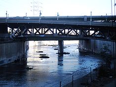
, forming alluvial flood plains along its banks. It now flows through a concrete channel on a fixed course.
Environmental groups and park advocates support the removal of concrete and the restoration of natural
vegetation
and wildlife
. There are also plans for a series of parks along the river's city frontage in Los Angeles
. The Los Angeles River also flows through several Los Angeles County communities and has been
featured in many Hollywood films.
Before the opening of the Los Angeles Aqueduct
, the river was the primary source of fresh water
for the city. Although the Los Angeles region still gets some of its water from the river and other local sources, most comes from several aqueducts serving the area. The river suffers pollution
from agricultural and urban runoff
.
 The Los Angeles River's official beginning is at the confluence of two channelized streams - Bell Creek
and Arroyo Calabasas
- in the Canoga Park section of the city of Los Angeles, just east of California State Route 27
, at 34.1952°N 118.601838°W. Bell Creek flows east from the Simi Hills
, and Arroyo Calabasas flows north from the Santa Monica Mountains
. From there the river flows east through a concrete flood control channel and very soon receives Browns Canyon Wash
, which flows south from the Santa Susana Mountains
, from the left. The river then bends slightly south and receives Aliso Canyon Wash
, whose watershed adjoins that of Browns Canyon, from the left. The river then flows into the town of Winnetka
, then Reseda
and enters the Sepulveda Basin, a flood-control reservoir formed by the Sepulveda Dam
.
 As the river proceeds into the usually-dry reservoir, it spills out into a channel that is similar to its historical, unchannelized form. It crosses under Balboa Boulevard and then passes through the outlet works
of Sepulveda Dam, 43 miles (69.2 km) from the mouth. It flows again into a concrete channel and crosses under Interstate 405
as it passes through Van Nuys, Sherman Oaks, and Studio City, still flowing east. Paralleling U.S. Highway 101 briefly, it then veers southeast, away from the highway, and receives from the left the Tujunga Wash
, one of its largest tributaries, which flows southwest and south from the Angeles National Forest
in the San Gabriel Mountains
. The river then rounds a bend to the northeast, now in a concrete box culvert, and crosses under State Route 170
and Highway 101, and receives Burbank Western Channel
on the left bank, 39 miles (62.8 km) from the mouth.
The river then begins to parallel California State Route 134 as it winds past the city of Burbank
and North Hollywood, then crosses under Interstate 5
and makes a sharp bend to the south-southeast as it curves around Griffith Park
. It receives from the left Verdugo Canyon Wash, which drains much of La Cañada Flintridge and Glendale
as it flows from the San Gabriel Mountains south through a water gap
in the Verdugo Mountains
, and crosses under State Route 134. Here, the river begins to flow over a natural riverbed, but enters another concrete section soon after. Paralleling Interstate 5 for the next few miles, the river runs by the eastern side of Griffith Park and the Harding-Wilson Golf Course. It passes Silver Lake Reservoir
, which is to the right, and crosses under California State Route 2, 32 miles (51.5 km) from the mouth.
Making two meanders as it flows in a southeasterly direction, the river parallels the interstate and Riverside Drive
then crosses under the interstate and California State Route 110 as it flows east of Elysian Park. It then receives the Arroyo Seco
, another major tributary, from the left. The river flows south past the Mission Junction, a large railroad yard on the left. It enters a wider concrete channel with sloped sides, and crosses under Cesar Chavez Avenue, Highway 101, and Interstate 10
as it passes east of downtown Los Angeles
, flowing past the East Los Angeles Interchange
for Highway 101, California State Route 60
, and Interstates 5 and 10 on the left. It then makes a gradual turn east and then turns southeast, flowing a few miles before it begins to parallel Interstate 710
near Maywood
, Bell
, Cudahy
, and Commerce
, 20 miles (32.2 km) from the mouth.
Paralleling Interstate 710 south-southwest, the river then crosses under California State Route 42 and the interstate as it receives the Rio Hondo
from the left, 9 miles (14.5 km) from the mouth. The Rio Hondo (deep river) now serves as a distributary
for the San Gabriel River
to the east via the Whittier Narrows Reservoir. The river then crosses under Interstate 105
and shifts slightly southwest, then flows east of Compton
and west of Bellflower
. After crossing under California State Route 91
, it receives Compton Creek
from the right, 2.7 miles (4.3 km) from the mouth. After crossing under Interstate 405 for the second time, 2 miles (3.2 km) from the mouth, it draws close to the Dominguez Channel
to the west and flows due south to its outlet in Long Beach
, under Interstate 710, past the RMS Queen Mary
, and into the Port of Los Angeles
.
 The river provided a source of water and food for the Gabrielino Indians for hundreds of years prior to the arrival of the Spanish. The Gabrielinos were hunters and gatherers who lived primarily off the fish
, small mammal
s, and acorn
s from the abundant oak
trees along the river's path. There were at least 45 Gabrielino villages located near the Los Angeles River, concentrated in the San Fernando Valley, and Elysian Valley in what is present day Glendale. In 1769, Gaspar de Portolà
during his 1769 expedition
of Alta California named it El Río de Nuestra Señora La Reina de Los Ángeles de Porciúncula, so translated: The River of Our Lady Queen of the Angels of Porciuncula
. It was referred to as the Porciuncula River.
The river was originally an alluvial river that ran freely across a flood plain that is now occupied by Los Angeles, Long Beach, and other townships in Southern California. Its path was unstable and unpredictable, and the mouth of the river moved frequently from one place to another between Long Beach and Ballona Creek. In the early nineteenth Century, the river turned southwest after leaving the Glendale Narrows, where it joined Ballona Creek
and discharged into Santa Monica Bay
in present Marina del Rey. During a catastrophic flash flood
in 1825, its course was diverted again to its present one, flowing due south just east of present-day downtown Los Angeles
and discharging into San Pedro Bay
. (Prior to the Great Flood of 1862
, it was joined by the San Gabriel River
in present-day Long Beach
, but in that year the San Gabriel carved out a new course 6 miles (9.7 km) to the east, and has discharged into Alamitos Bay
ever since.)
Until the opening of the Los Angeles Aqueduct
, the Los Angeles River was the primary water source for the Los Angeles Basin
, but much of its channel had extremely low discharge except during the winter rains. Unpredictable and devastating floods continued to plague it well into the 1930s (the most notable one being the catastrophic 1938 flood
that precipitated the recall of Los Angeles then-mayor Frank L. Shaw
), leading to calls for flood control measures. The Army Corps of Engineers duly began an ambitious project of completely encasing the river's bed and banks in concrete
, with only a trickle of water usually flowing down its middle. Ever since, it has served primarily as a flood control channel, fed by storm drain
s. The only portions of the river that are not completely paved over are in the flood-control basin behind the Sepulveda Dam
near Van Nuys
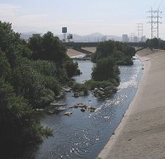
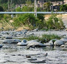
; a 3-mile (5-km) stretch east of Griffith Park
known as the Glendale Narrows; and along its last few miles in Long Beach.
The Los Angeles River bicycle path
runs through the Glendale Narrows and is accessible to the public at its north end at Riverside Drive, at Los Feliz Boulevard, and at its south end at Glendale Boulevard. The bike path runs parallel to the 5 freeway for the majority of its length and has mile markers and call boxes for information and safety purposes.
The river's southern stretch forms the heart of an industrial corridor, stretching nearly unbroken from Lincoln Heights
to Long Beach
. In this area, the busy Long Beach Freeway (I-710) and several high-voltage power lines run within a few hundred feet of the riverbed. Several rail yard
s are located along the river's banks in this stretch, as well. Just outside of the industrial corridor lie some of the most densely populated cities in the state of California, such as the cities of Bell
, Cudahy
and South Gate
; most of these cities are in the river's flood plain and experienced significant flooding prior to channelization.
), black bullhead (Ameiurus melas), Amazon sailfin catfish (Pterygoplichthys pardalis
), carp (Cyprinue carpio), fathead minnow (Pimephales promelas), and mosquitofish (Gambusia affinis) as living in the river. While throughout its history the river supported populations of Rainbow Trout
, the last one documented caught in the river was in the 1940s. The river also supports a number of bird species, including Great Blue Heron
, Snowy Egret
, Mallard
, Cinnamon Teal
, American Coot
, Black-necked Stilt
and Muscovy Duck
.
There is indirect evidence that North American beaver (Castor canadensis) were native to the river, as the Beñemé (Mojave
) and Jeniguechi (San Jacinto
branch of the Cahuilla
) Indians of the San Gabriel Mission
were described by Father Pedro Font on the second de Anza Expedition in 1776, "The costume of the men in heathendom is total nakedness, while the women wear a bit of deer skin with which they cover themselves, and likewise an occasional cloak of beaver or rabbit skin, although the fathers endeavor to clothe the converted Indians with something as best they can."
, the City of Los Angeles’ Department of Public Works-Bureau of Engineering issued a Request for Proposals in 2005 for the preparation of a Revitalization Master Plan, which would identify proposals that would make the Los Angeles River a “front door” to the City, and support a multitude of civic activities.
The 18-month revitalization planning process looked at improvements along the project area all aimed toward protecting wildlife, promoting the health of the river, and leveraging economic development. By the end of the planning process, a 20-year blueprint for development and management of the Los Angeles River was developed for implementation by the City of Los Angeles. The plan was officially adopted by the City of Los Angeles in May 2007.
Friends of the Los Angeles River (FoLAR) and other environmental groups have been advocating restoration of the river, creation of a wildlife corridor from the mountains to the sea, and a radical change in the way rainwater on individual properties is dealt with.
The Mountains Recreation and Conservation Authority, has a powerful State mandate
to connect Elysian and Griffith Parks to the mountains. With an initial budget of $1,000,000, MRCA is evaluating the acquisition of properties to create parks and trails along the river between the two large parks. (See the article by Ester Feldman in the April '94 TPR).
The Los Angeles & San Gabriel Rivers Watershed Council
is a nonprofit organization that works with government agencies, business leaders, community groups, and academics to facilitate an inclusive consensus process aimed at preserving, restoring, and enhancing the social, ecological, and economic health of the Los Angeles River and San Gabriel River watersheds through education, research, and planning.
The California Coastal Conservancy
, a state agency, published its Los Angeles River Park and Recreation Study in 1993, identifying potential projects along the river. In November 2005, Unpave LA sponsored a conference, 'Rethinking the River', to promote discussion of Los Angeles River management options. In 2006, Mayor Villaraigosa visited South Korea to look at their river restoration project, the Cheonggyecheon
.

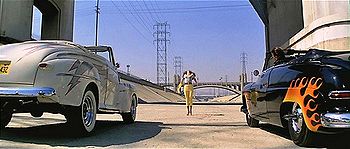
, Chinatown, Them!, Blue Thunder
, Escape from L.A.
, Terminator 2: Judgment Day
, Last Action Hero
, Stand and Deliver
, Grease
, Volcano, Point Blank, Freaky Friday
, Roadblock, Hot Rod Girl, Southland
, Blood in Blood Out
, Boomtown, This Christmas
, Rize, The Core
, Repo Man, The Italian Job
, One Eight Seven
, Point Break
, Gone in 60 Seconds, Transformers, 24
, Emergency!
, The Gumball Rally
, To Live and Die in L.A., The First Power
, Purple Rain
, L.A. Zombie
, Transformers: Revenge of the Fallen
, Drive
, and High School High
.
Television shows involving the river include The Beverly Hillbillies
, The Tonight Show with Conan O'Brien
, Funny or Die Presents
, a skit on the show Jackass
(in which Johnny Knoxville
tries to jump a section on roller blades, but sprains his ankle), Family Guy
and The Venture Bros.
. Discovery Channel
filmed scenes of The Colony
in the Los Angeles River, where the participants drank water and ate fish from the river. Los Angeles River served as the starting line for the fifteenth season of The Amazing Race
.
 A number of music videos have also been filmed at the Los Angeles River, including:
A few video games also feature the Los Angeles River as a setting, including:
Terms
San Fernando Valley
The San Fernando Valley is an urbanized valley located in the Los Angeles metropolitan area of southern California, United States, defined by the dramatic mountains of the Transverse Ranges circling it...
, in the Simi Hills
Simi Hills
The Simi Hills are a low rocky mountain range of the Transverse Ranges, located in eastern Ventura County and western Los Angeles County, of southern California, United States.-Geography:...
and Santa Susana Mountains
Santa Susana Mountains
The Santa Susana Mountains are a transverse range of mountains in southern California, north of the city of Los Angeles, in the United States. The range runs east-west separating the San Fernando Valley and Simi Valley on its south, from Santa Clara River Valley to the north, and Santa Clarita...
, and flows through Los Angeles County, California
Los Angeles County, California
Los Angeles County is a county in the U.S. state of California. As of 2010 U.S. Census, the county had a population of 9,818,605, making it the most populous county in the United States. Los Angeles County alone is more populous than 42 individual U.S. states...
, from Canoga Park
Canoga Park, Los Angeles, California
Canoga Park is a district in the San Fernando Valley region of Los Angeles, California, United States about 25 miles northwest of Downtown Los Angeles....
in the western end of the San Fernando Valley, nearly 48 miles (77.2 km) southeast to its mouth in Long Beach
Long Beach, California
Long Beach is a city situated in Los Angeles County in Southern California, on the Pacific coast of the United States. The city is the 36th-largest city in the nation and the seventh-largest in California. As of 2010, its population was 462,257...
. Several tributaries join the once free-flowing and frequently flooding river
River
A river is a natural watercourse, usually freshwater, flowing towards an ocean, a lake, a sea, or another river. In a few cases, a river simply flows into the ground or dries up completely before reaching another body of water. Small rivers may also be called by several other names, including...
, forming alluvial flood plains along its banks. It now flows through a concrete channel on a fixed course.
Environmental groups and park advocates support the removal of concrete and the restoration of natural
Natural
Natural is an adjective that refers to Nature.Natural may refer too:In science and mathematics:* Natural transformation, category theory in mathematics* Natural foods...
vegetation
Vegetation
Vegetation is a general term for the plant life of a region; it refers to the ground cover provided by plants. It is a general term, without specific reference to particular taxa, life forms, structure, spatial extent, or any other specific botanical or geographic characteristics. It is broader...
and wildlife
Wildlife
Wildlife includes all non-domesticated plants, animals and other organisms. Domesticating wild plant and animal species for human benefit has occurred many times all over the planet, and has a major impact on the environment, both positive and negative....
. There are also plans for a series of parks along the river's city frontage in Los Angeles
Los Ángeles
Los Ángeles is the capital of the province of Biobío, in the commune of the same name, in Region VIII , in the center-south of Chile. It is located between the Laja and Biobío rivers. The population is 123,445 inhabitants...
. The Los Angeles River also flows through several Los Angeles County communities and has been
featured in many Hollywood films.
Before the opening of the Los Angeles Aqueduct
Los Angeles Aqueduct
The Los Angeles Aqueduct system comprising the Los Angeles Aqueduct and the Second Los Angeles Aqueduct, is a water conveyance system operated by the Los Angeles Department of Water and Power...
, the river was the primary source of fresh water
Fresh Water
Fresh Water is the debut album by Australian rock and blues singer Alison McCallum, released in 1972. Rare for an Australian artist at the time, it came in a gatefold sleeve...
for the city. Although the Los Angeles region still gets some of its water from the river and other local sources, most comes from several aqueducts serving the area. The river suffers pollution
Water pollution
Water pollution is the contamination of water bodies . Water pollution occurs when pollutants are discharged directly or indirectly into water bodies without adequate treatment to remove harmful compounds....
from agricultural and urban runoff
Urban runoff
Urban runoff is surface runoff of rainwater created by urbanization. This runoff is a major source of water pollution in many parts of the United States and other urban communities worldwide.-Overview:...
.
Course
Bell Creek (Southern California)
Bell Creek is a tributary of the Los Angeles River, in the Simi Hills of Ventura County and the San Fernando Valley of Los Angeles County and City, in Southern California.-Route:...
and Arroyo Calabasas
Arroyo Calabasas
Arroyo Calabasas is a tributary of the Los Angeles River, in the southwestern San Fernando Valley area of Los Angeles County in California.-Route:...
- in the Canoga Park section of the city of Los Angeles, just east of California State Route 27
California State Route 27
State Route 27 is a state highway in the U.S. state of California that runs from Pacific Coast Highway at Topanga State Beach near Pacific Palisades, through Topanga Canyon including the community of Fernwood Pacific also known as Topanga, and continuing through Woodland Hills, Canoga Park, West...
, at 34.1952°N 118.601838°W. Bell Creek flows east from the Simi Hills
Simi Hills
The Simi Hills are a low rocky mountain range of the Transverse Ranges, located in eastern Ventura County and western Los Angeles County, of southern California, United States.-Geography:...
, and Arroyo Calabasas flows north from the Santa Monica Mountains
Santa Monica Mountains
The Santa Monica Mountains are a Transverse Range in Southern California, along the coast of the Pacific Ocean in the United States.-Geography:...
. From there the river flows east through a concrete flood control channel and very soon receives Browns Canyon Wash
Browns Canyon Wash
Browns Canyon Wash is a tributary of the Los Angeles River in the western San Fernando Valley of Los Angeles County, California....
, which flows south from the Santa Susana Mountains
Santa Susana Mountains
The Santa Susana Mountains are a transverse range of mountains in southern California, north of the city of Los Angeles, in the United States. The range runs east-west separating the San Fernando Valley and Simi Valley on its south, from Santa Clara River Valley to the north, and Santa Clarita...
, from the left. The river then bends slightly south and receives Aliso Canyon Wash
Aliso Creek (Los Angeles County)
Aliso Creek is a major tributary of the Los Angeles River in Los Angeles County, California, with a watershed of . It is the second major tributary to enter the Los Angeles River downstream of the Bell Creek/Calabasas Creek merge. The stream runs about from Aliso Canyon below Oat Mountain to its...
, whose watershed adjoins that of Browns Canyon, from the left. The river then flows into the town of Winnetka
Winnetka, Los Angeles, California
Winnetka is a district in the west-central San Fernando Valley in the City of Los Angeles.Winnetka is located next to Canoga Park on the west, Woodland Hills on the south, Chatsworth to the north, and Reseda to the east...
, then Reseda
Reseda, Los Angeles, California
Reseda is a San Fernando Valley district in the city of Los Angeles, California.-History:The area now known as Reseda was originally inhabited by Native Americans of the Tongva tribe that lived close to the Los Angeles River....
and enters the Sepulveda Basin, a flood-control reservoir formed by the Sepulveda Dam
Sepulveda Dam
Located in Los Angeles, California, the Sepulveda Dam is a project of the U.S. Army Corps of Engineers, built in 1941 to withhold winter flood waters along the Los Angeles River...
.
Outlet works
A set of outlet works is a device used to release and regulate water flow from a dam. Such devices usually consist of one or more pipes or tunnels through the embankment of the dam, directing water usually under high pressure to the river downstream...
of Sepulveda Dam, 43 miles (69.2 km) from the mouth. It flows again into a concrete channel and crosses under Interstate 405
Interstate 405
Interstate 405 may refer to:* Interstate 405 , a bypass of Los Angeles, California* Interstate 405 , a loop in Portland, Oregon* Interstate 405 , a bypass of Seattle, Washington...
as it passes through Van Nuys, Sherman Oaks, and Studio City, still flowing east. Paralleling U.S. Highway 101 briefly, it then veers southeast, away from the highway, and receives from the left the Tujunga Wash
Tujunga Wash
Tujunga Wash is a stream in Los Angeles County, California. It is a tributary of the Los Angeles River, providing about a fifth of its flow, and drains about...
, one of its largest tributaries, which flows southwest and south from the Angeles National Forest
Angeles National Forest
The Angeles National Forest of the U.S. National Forest Service is located in the San Gabriel Mountains of Los Angeles County, southern California. It was established on July 1, 1908, incorporating the first San Bernardino National Forest and parts of the former Santa Barbara and San Gabriel...
in the San Gabriel Mountains
San Gabriel Mountains
The San Gabriel Mountains Range is located in northern Los Angeles County and western San Bernardino County, California, United States. The mountain range lies between the Los Angeles Basin and the Mojave Desert, with Interstate 5 to the west and Interstate 15 to the east...
. The river then rounds a bend to the northeast, now in a concrete box culvert, and crosses under State Route 170
State Route 170 (California)
State Route 170 is a California State Highway in the city of Los Angeles that runs in a north–south direction. It is composed of two distinct sections. The first is the part of Highland Avenue that starts from Santa Monica Boulevard and ends at U.S. Route 101...
and Highway 101, and receives Burbank Western Channel
Burbank Western Channel
Burbank Western Channel is a tributary of the Los Angeles River in the eastern San Fernando Valley of Los Angeles County, California....
on the left bank, 39 miles (62.8 km) from the mouth.
The river then begins to parallel California State Route 134 as it winds past the city of Burbank
Burbank, California
Burbank is a city in Los Angeles County in Southern California, United States, north of downtown Los Angeles. The estimated population in 2010 was 103,340....
and North Hollywood, then crosses under Interstate 5
Interstate 5
Interstate 5 is the main Interstate Highway on the West Coast of the United States, running largely parallel to the Pacific Ocean coastline from Canada to Mexico . It serves some of the largest cities on the U.S...
and makes a sharp bend to the south-southeast as it curves around Griffith Park
Griffith Park
Griffith Park is a large municipal park at the eastern end of the Santa Monica Mountains in the Los Feliz neighborhood of Los Angeles, California. The park covers of land, making it one of the largest urban parks in North America...
. It receives from the left Verdugo Canyon Wash, which drains much of La Cañada Flintridge and Glendale
Glendale, California
Glendale is a city in Los Angeles County, California, United States. As of the 2010 Census, the city population is 191,719, down from 194,973 at the 2000 census. making it the third largest city in Los Angeles County and the 22nd largest city in the state of California...
as it flows from the San Gabriel Mountains south through a water gap
Water gap
A water gap is an opening or notch which flowing water has carved through a mountain range. Water gaps often offer a practical route for road and rail transport to cross mountain ridges.- Geology :...
in the Verdugo Mountains
Verdugo Mountains
The Verdugo Mountains are a small, rugged mountain range of the Transverse Ranges system, located just south of the western San Gabriel Mountains in Los Angeles County, Southern California...
, and crosses under State Route 134. Here, the river begins to flow over a natural riverbed, but enters another concrete section soon after. Paralleling Interstate 5 for the next few miles, the river runs by the eastern side of Griffith Park and the Harding-Wilson Golf Course. It passes Silver Lake Reservoir
Silver Lake Reservoir
The Silver Lake Reservoirs comprise two concrete-lined basins, Ivanhoe Reservoir and Silver Lake, divided by a spillway, in the Silver Lake community of Los Angeles, California.-History:...
, which is to the right, and crosses under California State Route 2, 32 miles (51.5 km) from the mouth.
Making two meanders as it flows in a southeasterly direction, the river parallels the interstate and Riverside Drive
Riverside Drive (Los Angeles, California)
Riverside Drive is a northeast-southwest road connecting the San Fernando Valley and Downtown Los Angeles, California. It follows the course of the Los Angeles River.-Overview:...
then crosses under the interstate and California State Route 110 as it flows east of Elysian Park. It then receives the Arroyo Seco
Arroyo Seco (Los Angeles County)
The Arroyo Seco, meaning "dry stream" in Spanish, is a seasonal river, canyon, watershed, and cultural area in Los Angeles County, California, United States. The Arroyo Seco has been called the most celebrated canyon in Southern California.-River course:...
, another major tributary, from the left. The river flows south past the Mission Junction, a large railroad yard on the left. It enters a wider concrete channel with sloped sides, and crosses under Cesar Chavez Avenue, Highway 101, and Interstate 10
Interstate 10
Interstate 10 is the fourth-longest Interstate Highway in the United States, after I-90, I-80, and I-40. It is the southernmost east–west, coast-to-coast Interstate Highway, although I-4 and I-8 are further south. It stretches from the Pacific Ocean at State Route 1 in Santa Monica,...
as it passes east of downtown Los Angeles
Downtown Los Angeles
Downtown Los Angeles is the central business district of Los Angeles, California, United States, located close to the geographic center of the metropolitan area...
, flowing past the East Los Angeles Interchange
East Los Angeles Interchange
The East Los Angeles Interchange complex is the busiest freeway interchange in the world, with its southern portion handling over 550,000 vehicles per day . The northern portion, called the San Bernardino Split, is often considered a separate interchange. The interchange was named the Eugene A....
for Highway 101, California State Route 60
California State Route 60
State Route 60 is a state highway in the U.S. state of California. It runs from Interstate 10 near the Los Angeles River in Los Angeles east to I-10 in Riverside County, with overlaps at State Route 57 and Interstate 215.-Route description:...
, and Interstates 5 and 10 on the left. It then makes a gradual turn east and then turns southeast, flowing a few miles before it begins to parallel Interstate 710
Interstate 710
Interstate 710 is a major north–south interstate freeway running for 23 miles through Los Angeles County, California...
near Maywood
Maywood, California
Maywood is a small city in southeast Los Angeles County, California. At , Maywood is the third-smallest incorporated city in Los Angeles County....
, Bell
Bell, California
Bell is a city in Los Angeles County, California. Its population was 35,477 at the 2010 census, down from 36,664 in the 2000 census. Bell is located on the west bank of the Los Angeles River and is a suburb of the city of Los Angeles...
, Cudahy
Cudahy, California
Cudahy is a city located in southeastern Los Angeles County, California. In terms of area, Cudahy is the second smallest city in Los Angeles County, after Hawaiian Gardens. with one of the highest population densities of any incorporated city in the United States...
, and Commerce
Commerce, California
Commerce is a city located in southeast Los Angeles County, California, United States. The population was 12,823 at the 2010 census, up from 12,568 at the 2000 census. It is bordered by Vernon on the west, Los Angeles on the northwest, East Los Angeles on the north, Montebello on the east, Downey...
, 20 miles (32.2 km) from the mouth.
Paralleling Interstate 710 south-southwest, the river then crosses under California State Route 42 and the interstate as it receives the Rio Hondo
Rio Hondo (California)
The Rio Hondo is a tributary of the Los Angeles River in Los Angeles County, California, approximately long. As a named river, it begins in Irwindale and flows southwest to its confluence in South Gate, passing through several cities...
from the left, 9 miles (14.5 km) from the mouth. The Rio Hondo (deep river) now serves as a distributary
Distributary
A distributary, or a distributary channel, is a stream that branches off and flows away from a main stream channel. They are a common feature of river deltas. The phenomenon is known as river bifurcation. The opposite of a distributary is a tributary...
for the San Gabriel River
San Gabriel River (California)
The San Gabriel River flows through southern Los Angeles County, California in the United States. Its main stem is about long, while its farthest tributaries extend almost altogether...
to the east via the Whittier Narrows Reservoir. The river then crosses under Interstate 105
Interstate 105
Interstate 105 may refer to:*Interstate 105 , a spur in Los Angeles County, California*Interstate 105 , a spur in Eugene, Oregon...
and shifts slightly southwest, then flows east of Compton
Compton, California
Compton is a city in southern Los Angeles County, California, United States, southeast of downtown Los Angeles. The city of Compton is one of the oldest cities in the county and on May 11, 1888, was the eighth city to incorporate. The city is considered part of the South side by residents of Los...
and west of Bellflower
Bellflower, California
Bellflower is a city in Los Angeles County, California, and is a suburb of Los Angeles. It was incorporated on September 3, 1957. As of the 2010 census, the city had a total population of 76,616, up from 72,878 at the 2000 census....
. After crossing under California State Route 91
California State Route 91
State Route 91 is a major east–west freeway located entirely within Southern California and serving several regions of the Greater Los Angeles metropolitan area...
, it receives Compton Creek
Compton Creek
Compton Creek is a major tributary of the Los Angeles River in and surrounding Compton in Los Angeles County, California, and it is in desperate need of salvation. The stream drains a watershed of...
from the right, 2.7 miles (4.3 km) from the mouth. After crossing under Interstate 405 for the second time, 2 miles (3.2 km) from the mouth, it draws close to the Dominguez Channel
Dominguez Channel
Dominguez Channel is a stream in southern Los Angeles County, California that drains the Dominguez Watershed of . The watershed area is 96% developed, largely residential, and artificially bounded by a system of storm drains and flood control channels....
to the west and flows due south to its outlet in Long Beach
Long Beach, California
Long Beach is a city situated in Los Angeles County in Southern California, on the Pacific coast of the United States. The city is the 36th-largest city in the nation and the seventh-largest in California. As of 2010, its population was 462,257...
, under Interstate 710, past the RMS Queen Mary
RMS Queen Mary
RMS Queen Mary is a retired ocean liner that sailed primarily in the North Atlantic Ocean from 1936 to 1967 for the Cunard Line...
, and into the Port of Los Angeles
Port of Los Angeles
The Port of Los Angeles, also called Los Angeles Harbor and WORLDPORT L.A, is a port complex that occupies of land and water along of waterfront. The port is located on San Pedro Bay in the San Pedro neighborhood of Los Angeles, approximately south of downtown...
.
History
Fish
Fish are a paraphyletic group of organisms that consist of all gill-bearing aquatic vertebrate animals that lack limbs with digits. Included in this definition are the living hagfish, lampreys, and cartilaginous and bony fish, as well as various extinct related groups...
, small mammal
Mammal
Mammals are members of a class of air-breathing vertebrate animals characterised by the possession of endothermy, hair, three middle ear bones, and mammary glands functional in mothers with young...
s, and acorn
Acorn
The acorn, or oak nut, is the nut of the oaks and their close relatives . It usually contains a single seed , enclosed in a tough, leathery shell, and borne in a cup-shaped cupule. Acorns vary from 1–6 cm long and 0.8–4 cm broad...
s from the abundant oak
Oak
An oak is a tree or shrub in the genus Quercus , of which about 600 species exist. "Oak" may also appear in the names of species in related genera, notably Lithocarpus...
trees along the river's path. There were at least 45 Gabrielino villages located near the Los Angeles River, concentrated in the San Fernando Valley, and Elysian Valley in what is present day Glendale. In 1769, Gaspar de Portolà
Gaspar de Portolà
Gaspar de Portolà i Rovira was a soldier, governor of Baja and Alta California , explorer and founder of San Diego and Monterey. He was born in Os de Balaguer, province of Lleida, in Catalonia, Spain, of Catalan nobility. Don Gaspar served as a soldier in the Spanish army in Italy and Portugal...
during his 1769 expedition
Portola expedition
250px|right|Point of San Francisco Bay DiscoveryThe Portolá Expedition was led by Gaspar de Portolá from July 14, 1769 to January 24, 1770. It was the first recorded Spanish land entry and exploration of present day California, United States...
of Alta California named it El Río de Nuestra Señora La Reina de Los Ángeles de Porciúncula, so translated: The River of Our Lady Queen of the Angels of Porciuncula
Porziuncola
Porziuncola, also called Portiuncula or Porzioncula, Porciúncula is a small church located within the Basilica of Santa Maria degli Angeli in the frazione of Santa Maria degli Angeli, situated about from Assisi, Umbria...
. It was referred to as the Porciuncula River.
The river was originally an alluvial river that ran freely across a flood plain that is now occupied by Los Angeles, Long Beach, and other townships in Southern California. Its path was unstable and unpredictable, and the mouth of the river moved frequently from one place to another between Long Beach and Ballona Creek. In the early nineteenth Century, the river turned southwest after leaving the Glendale Narrows, where it joined Ballona Creek
Ballona Creek
Ballona Creek is an waterway in southwestern Los Angeles County, California, whose watershed drains the Los Angeles basin, from the Santa Monica Mountains on the north, the Harbor Freeway on the east, and the Baldwin Hills on the south...
and discharged into Santa Monica Bay
Santa Monica Bay
Santa Monica Bay is a bight of the Pacific Ocean in southern California, United States. Its boundaries are slightly ambiguous, but it is generally considered to be the part of the Pacific within an imaginary line drawn between Point Dume, in Malibu, and the Palos Verdes Peninsula. Its eastern...
in present Marina del Rey. During a catastrophic flash flood
Flash flood
A flash flood is a rapid flooding of geomorphic low-lying areas—washes, rivers, dry lakes and basins. It may be caused by heavy rain associated with a storm, hurricane, or tropical storm or meltwater from ice or snow flowing over ice sheets or snowfields...
in 1825, its course was diverted again to its present one, flowing due south just east of present-day downtown Los Angeles
Los Angeles, California
Los Angeles , with a population at the 2010 United States Census of 3,792,621, is the most populous city in California, USA and the second most populous in the United States, after New York City. It has an area of , and is located in Southern California...
and discharging into San Pedro Bay
San Pedro Bay (California)
San Pedro Bay is an inlet on the Pacific Ocean coast of southern California, United States. It is the site of the Port of Los Angeles and the Port of Long Beach, which together form the fifth-busiest port facility in the world and easily the busiest in the Western Hemisphere...
. (Prior to the Great Flood of 1862
Great Flood of 1862
The Great Flood of 1862 or Noachian Deluge was the largest flood in the recorded history of Oregon, Nevada and California, occurring from December 1861 to January 1862. It was preceded by weeks of continuous rains that began in Oregon in November 1861 and continued into January 1862...
, it was joined by the San Gabriel River
San Gabriel River (California)
The San Gabriel River flows through southern Los Angeles County, California in the United States. Its main stem is about long, while its farthest tributaries extend almost altogether...
in present-day Long Beach
Long Beach, California
Long Beach is a city situated in Los Angeles County in Southern California, on the Pacific coast of the United States. The city is the 36th-largest city in the nation and the seventh-largest in California. As of 2010, its population was 462,257...
, but in that year the San Gabriel carved out a new course 6 miles (9.7 km) to the east, and has discharged into Alamitos Bay
Alamitos Bay
Alamitos Bay is an inlet on the Pacific Ocean coast of southern California, United States, between the cities of Long Beach and Seal Beach, at the outlet of the San Gabriel River.The bay is named for the Spanish word for 'little poplars'.-Geography:...
ever since.)
Until the opening of the Los Angeles Aqueduct
Los Angeles Aqueduct
The Los Angeles Aqueduct system comprising the Los Angeles Aqueduct and the Second Los Angeles Aqueduct, is a water conveyance system operated by the Los Angeles Department of Water and Power...
, the Los Angeles River was the primary water source for the Los Angeles Basin
Los Angeles Basin
The Los Angeles Basin is the coastal sediment-filled plain located between the Peninsular and Transverse ranges in southern California in the United States containing the central part of the city of Los Angeles as well as its southern and southeastern suburbs...
, but much of its channel had extremely low discharge except during the winter rains. Unpredictable and devastating floods continued to plague it well into the 1930s (the most notable one being the catastrophic 1938 flood
Los Angeles Flood of 1938
The Los Angeles Flood of 1938 or 1938 Los Angeles flood was a major flooding event that was responsible for inundating much of Los Angeles, Orange, and Riverside counties, California, during early 1938...
that precipitated the recall of Los Angeles then-mayor Frank L. Shaw
Frank L. Shaw
Frank L. Shaw was the first mayor of a major American city to be recalled from office, in 1938. He was also a member of the Los Angeles City Council and then the Los Angeles County Board of Supervisors...
), leading to calls for flood control measures. The Army Corps of Engineers duly began an ambitious project of completely encasing the river's bed and banks in concrete
Concrete
Concrete is a composite construction material, composed of cement and other cementitious materials such as fly ash and slag cement, aggregate , water and chemical admixtures.The word concrete comes from the Latin word...
, with only a trickle of water usually flowing down its middle. Ever since, it has served primarily as a flood control channel, fed by storm drain
Storm drain
A storm drain, storm sewer , stormwater drain or drainage well system or simply a drain or drain system is designed to drain excess rain and ground water from paved streets, parking lots, sidewalks, and roofs. Storm drains vary in design from small residential dry wells to large municipal systems...
s. The only portions of the river that are not completely paved over are in the flood-control basin behind the Sepulveda Dam
Sepulveda Dam
Located in Los Angeles, California, the Sepulveda Dam is a project of the U.S. Army Corps of Engineers, built in 1941 to withhold winter flood waters along the Los Angeles River...
near Van Nuys
Van Nuys, Los Angeles, California
Van Nuys is a neighborhood in the San Fernando Valley region of Los Angeles, California.-History:Look at the two photos of Van Nuys' first year—and then listen to what the Los Angeles Times wrote on February 23, 1911, the day after the Van Nuys town lot auction--"Between dawn and dusk, in the...
; a 3-mile (5-km) stretch east of Griffith Park
Griffith Park
Griffith Park is a large municipal park at the eastern end of the Santa Monica Mountains in the Los Feliz neighborhood of Los Angeles, California. The park covers of land, making it one of the largest urban parks in North America...
known as the Glendale Narrows; and along its last few miles in Long Beach.
Points of interest
Sepulveda Basin is a flood-control basin to control floodwater runoff. Except for infrequent but dramatic flood episodes, this dry-land flood control basin, most of which is leased from the Corps by the City of Los Angeles Department of Recreation and Parks, plays host to diverse uses today including athletic fields, agriculture, golf courses, a fishing lake, parklands, a sewage treatment facility, and a wildlife reserve.The Los Angeles River bicycle path
Los Angeles River bicycle path
The Los Angeles River bicycle path is, formally, a short bicycle path in the greater Los Angeles area, paralleling the Los Angeles River for approximately four miles as the river skirts the northern and eastern boundaries of Griffith Park in an area known as the Glendale Narrows.Following the Los...
runs through the Glendale Narrows and is accessible to the public at its north end at Riverside Drive, at Los Feliz Boulevard, and at its south end at Glendale Boulevard. The bike path runs parallel to the 5 freeway for the majority of its length and has mile markers and call boxes for information and safety purposes.
The river's southern stretch forms the heart of an industrial corridor, stretching nearly unbroken from Lincoln Heights
Lincoln Heights, Los Angeles, California
-Geography and transportation:Lincoln Heights is bounded by the Los Angeles River on the west, the San Bernardino Freeway on the south, and Indiana Street on the east; the district's Eastern border is unclear due to the area's uneven terrain...
to Long Beach
Long Beach, California
Long Beach is a city situated in Los Angeles County in Southern California, on the Pacific coast of the United States. The city is the 36th-largest city in the nation and the seventh-largest in California. As of 2010, its population was 462,257...
. In this area, the busy Long Beach Freeway (I-710) and several high-voltage power lines run within a few hundred feet of the riverbed. Several rail yard
Rail yard
A rail yard, or railroad yard, is a complex series of railroad tracks for storing, sorting, or loading/unloading, railroad cars and/or locomotives. Railroad yards have many tracks in parallel for keeping rolling stock stored off the mainline, so that they do not obstruct the flow of traffic....
s are located along the river's banks in this stretch, as well. Just outside of the industrial corridor lie some of the most densely populated cities in the state of California, such as the cities of Bell
Bell, California
Bell is a city in Los Angeles County, California. Its population was 35,477 at the 2010 census, down from 36,664 in the 2000 census. Bell is located on the west bank of the Los Angeles River and is a suburb of the city of Los Angeles...
, Cudahy
Cudahy, California
Cudahy is a city located in southeastern Los Angeles County, California. In terms of area, Cudahy is the second smallest city in Los Angeles County, after Hawaiian Gardens. with one of the highest population densities of any incorporated city in the United States...
and South Gate
South Gate, California
South Gate is a city in Los Angeles County, California, United States. The sixteenth largest city in Los Angeles County, it encompasses . South Gate is located just southeast of downtown Los Angeles It is part of the Gateway Cities region of southeastern Los Angeles County...
; most of these cities are in the river's flood plain and experienced significant flooding prior to channelization.
Wildlife
In a 2008 study, Friends of the Los Angeles River (FOLAR) documented largemouth bass (Micropterus salmoides), green sunfish (Lepomis cyanellus), tilapia (Oreochromis squamipinnisOreochromis squamipinnis
Oreochromis squamipinnis is a species of fish in the Cichlidae family. It is found in Malawi, Mozambique, and Tanzania. Its natural habitats are rivers and freshwater lakes.-Source:* Kazembe, J. & Makocho, P. 2004. . Downloaded on 4 August 2007....
), black bullhead (Ameiurus melas), Amazon sailfin catfish (Pterygoplichthys pardalis
Pterygoplichthys pardalis
Pterygoplichthys pardalis is a tropical fish, a Plecostomus in the Armored Catfish family . Some synonyms for this species are Hypostomus pardalis, Liposarcus pardalis, Liposarcus varius, and Liposarcus jeanesianus. It is one of a number of species commonly referred to as the Common Pleco or...
), carp (Cyprinue carpio), fathead minnow (Pimephales promelas), and mosquitofish (Gambusia affinis) as living in the river. While throughout its history the river supported populations of Rainbow Trout
Rainbow trout
The rainbow trout is a species of salmonid native to tributaries of the Pacific Ocean in Asia and North America. The steelhead is a sea run rainbow trout usually returning to freshwater to spawn after 2 to 3 years at sea. In other words, rainbow trout and steelhead trout are the same species....
, the last one documented caught in the river was in the 1940s. The river also supports a number of bird species, including Great Blue Heron
Great Blue Heron
The Great Blue Heron is a large wading bird in the heron family Ardeidae, common near the shores of open water and in wetlands over most of North and Central America as well as the West Indies and the Galápagos Islands. It is a rare vagrant to Europe, with records from Spain, the Azores and England...
, Snowy Egret
Snowy Egret
The Snowy Egret is a small white heron. It is the American counterpart to the very similar Old World Little Egret, which has established a foothold in the Bahamas....
, Mallard
Mallard
The Mallard , or Wild Duck , is a dabbling duck which breeds throughout the temperate and subtropical Americas, Europe, Asia, and North Africa, and has been introduced to New Zealand and Australia....
, Cinnamon Teal
Cinnamon Teal
The Cinnamon Teal is a small, reddish dabbling duck found in marshes and ponds of western North and South America.thumb|left|Female Anas cyanoptera septentrionalium...
, American Coot
American Coot
The American Coot is a bird of the family Rallidae, inhabiting wetlands and open water bodies. Measuring in length and across the wings, adults have a short thick white bill and white frontal shield, which usually has a reddish-brown spot near the top of the bill between the eyes...
, Black-necked Stilt
Black-necked Stilt
The Black-necked Stilt is a locally abundant shorebird of American wetlands and coastlines. It is found from the coastal areas of California through much of the interior western United States and along the Gulf of Mexico as far east as Florida, then south through Central America and the Caribbean...
and Muscovy Duck
Muscovy Duck
The Muscovy Duck is a large duck which is native to Mexico and Central and South America. A small wild population reaches into the United States in the lower Rio Grande Valley of Texas...
.
There is indirect evidence that North American beaver (Castor canadensis) were native to the river, as the Beñemé (Mojave
Mojave River
The Mojave River is an intermittent river in the eastern San Bernardino Mountains and Mojave Desert in San Bernardino County, California. The river is notable as most of its flow is underground, while its surface channels remain dry most of the time, with the exception of the headwaters and several...
) and Jeniguechi (San Jacinto
San Jacinto Mountains
The San Jacinto Mountains are a mountain range east of Los Angeles in southern California in the United States. The mountains are named for Saint Hyacinth . The Pacific Crest Trail runs along the spine of the range.The range extends for approximately from the San Bernardino Mountains southeast to...
branch of the Cahuilla
Cahuilla
The Cahuilla, Iviatim in their own language, are Indians with a common culture whose ancestors inhabited inland areas of southern California 2,000 years ago. Their original territory included an area of about . The traditional Cahuilla territory was near the geographic center of Southern California...
) Indians of the San Gabriel Mission
Mission San Gabriel Arcángel
The Mission San Gabriel Arcángel is a fully functioning Roman Catholic mission and a historic landmark in San Gabriel, California. The settlement was founded by Spaniards of the Franciscan order on "The Feast of the Birth of Mary," September 8, 1771, as the fourth of what would become 21 Spanish...
were described by Father Pedro Font on the second de Anza Expedition in 1776, "The costume of the men in heathendom is total nakedness, while the women wear a bit of deer skin with which they cover themselves, and likewise an occasional cloak of beaver or rabbit skin, although the fathers endeavor to clothe the converted Indians with something as best they can."
Revitalization
One of the initiatives shepherded by the Ad Hoc River Committee is the Los Angeles River Revitalization Master Plan. As a result of the Ad Hoc River Committee’s efforts, and with funding from the Los Angeles Department of Water and PowerLos Angeles Department of Water and Power
The Los Angeles Department of Water and Power is the largest municipal utility in the United States, serving over four million residents. It was founded in 1902 to supply water and electricity to residents and businesses in Los Angeles and surrounding communities...
, the City of Los Angeles’ Department of Public Works-Bureau of Engineering issued a Request for Proposals in 2005 for the preparation of a Revitalization Master Plan, which would identify proposals that would make the Los Angeles River a “front door” to the City, and support a multitude of civic activities.
The 18-month revitalization planning process looked at improvements along the project area all aimed toward protecting wildlife, promoting the health of the river, and leveraging economic development. By the end of the planning process, a 20-year blueprint for development and management of the Los Angeles River was developed for implementation by the City of Los Angeles. The plan was officially adopted by the City of Los Angeles in May 2007.
Friends of the Los Angeles River (FoLAR) and other environmental groups have been advocating restoration of the river, creation of a wildlife corridor from the mountains to the sea, and a radical change in the way rainwater on individual properties is dealt with.
The Mountains Recreation and Conservation Authority, has a powerful State mandate
Mandate (politics)
In politics, a mandate is the authority granted by a constituency to act as its representative.The concept of a government having a legitimate mandate to govern via the fair winning of a democratic election is a central idea of democracy...
to connect Elysian and Griffith Parks to the mountains. With an initial budget of $1,000,000, MRCA is evaluating the acquisition of properties to create parks and trails along the river between the two large parks. (See the article by Ester Feldman in the April '94 TPR).
The Los Angeles & San Gabriel Rivers Watershed Council
Los Angeles & San Gabriel Rivers Watershed Council
The Los Angeles & San Gabriel Rivers Watershed Council, recently renamed the Council for Watershed Health, was founded in 1996 with the objective of bringing together representatives from all of the water agencies , regulatory agencies, citizen groups, and businesses with responsibilities or...
is a nonprofit organization that works with government agencies, business leaders, community groups, and academics to facilitate an inclusive consensus process aimed at preserving, restoring, and enhancing the social, ecological, and economic health of the Los Angeles River and San Gabriel River watersheds through education, research, and planning.
The California Coastal Conservancy
California Coastal Conservancy
The California Coastal Conservancy is a state agency in California established in 1976 to enhance coastal resources and access.-Goals:The agency's official goals are to:*Protect and improve coastal wetlands, streams and watersheds...
, a state agency, published its Los Angeles River Park and Recreation Study in 1993, identifying potential projects along the river. In November 2005, Unpave LA sponsored a conference, 'Rethinking the River', to promote discussion of Los Angeles River management options. In 2006, Mayor Villaraigosa visited South Korea to look at their river restoration project, the Cheonggyecheon
Cheonggyecheon
Cheonggyecheon is an 8.4 km long, modern public recreation space in downtown Seoul, South Korea. The massive urban renewal project is on the site of a stream that flowed before the rapid post-war economic development required it to be covered by transportation infrastructure...
.
Riverside communities
Communities and cities along the banks of the Los Angeles River include:- Canoga ParkCanoga Park, Los Angeles, CaliforniaCanoga Park is a district in the San Fernando Valley region of Los Angeles, California, United States about 25 miles northwest of Downtown Los Angeles....
- WinnetkaWinnetka, Los Angeles, CaliforniaWinnetka is a district in the west-central San Fernando Valley in the City of Los Angeles.Winnetka is located next to Canoga Park on the west, Woodland Hills on the south, Chatsworth to the north, and Reseda to the east...
- ResedaReseda, Los Angeles, CaliforniaReseda is a San Fernando Valley district in the city of Los Angeles, California.-History:The area now known as Reseda was originally inhabited by Native Americans of the Tongva tribe that lived close to the Los Angeles River....
- Van NuysVan Nuys, Los Angeles, CaliforniaVan Nuys is a neighborhood in the San Fernando Valley region of Los Angeles, California.-History:Look at the two photos of Van Nuys' first year—and then listen to what the Los Angeles Times wrote on February 23, 1911, the day after the Van Nuys town lot auction--"Between dawn and dusk, in the...
- Sherman OaksSherman Oaks, Los Angeles, CaliforniaSherman Oaks is an affluent district in the San Fernando Valley area of the city of Los Angeles, California. In contrast to much of the Valley, the area is relatively urbanized, with commercial skyscrapers along Ventura Boulevard as well as scattered throughout...
- Studio CityStudio City, Los Angeles, CaliforniaStudio City is an affluent residential neighborhood within the City of Los Angeles, California in the San Fernando Valley. Studio City expands over four ZIP code areas: 91604 and sections of 91602, 91607 and 90210....
- Universal CityUniversal City, CaliforniaUniversal City is a community in the San Fernando Valley region of Los Angeles County, California, that encompasses the 415 acre property of Universal Studios...
- Toluca LakeToluca Lake, Los Angeles, CaliforniaToluca Lake is a district, north of downtown Los Angeles, in the San Fernando Valley region of the city of Los Angeles, California, and a "community within two communities, North Hollywood and Burbank"....
- BurbankBurbank, CaliforniaBurbank is a city in Los Angeles County in Southern California, United States, north of downtown Los Angeles. The estimated population in 2010 was 103,340....
- GlendaleGlendale, CaliforniaGlendale is a city in Los Angeles County, California, United States. As of the 2010 Census, the city population is 191,719, down from 194,973 at the 2000 census. making it the third largest city in Los Angeles County and the 22nd largest city in the state of California...
- Los FelizLos Feliz, Los Angeles, CaliforniaLos Feliz, also Rancho Los Feliz is an affluent, hilly neighborhood in the Hollywood district of Los Angeles, California, named after its land grantee José Vicente Feliz....
- Atwater VillageAtwater Village, Los Angeles, CaliforniaAtwater Village is a neighborhood in northeast Los Angeles, California. It lies at an elevation of 404 feet .-Geography:Atwater Village lies between the Los Angeles River to the west and Glendale to the north and east...
- Elysian ValleyElysian Valley, Los Angeles, CaliforniaElysian Valley is a small bedroom community of the City of Los Angeles, California.It is part of the Elysian Park-Silver Lake area.-History:...
- Glassell ParkGlassell Park, Los Angeles, CaliforniaGlassell Park is a neighborhood in northeast Los Angeles, California.-Geography:Glassell Park borders Atwater Village and the Los Angeles River on the west, the city of Glendale on the northwest, Eagle Rock on the northeast, Mount Washington on the southeast and Cypress Park on the south...
- Cypress ParkCypress Park, Los Angeles, CaliforniaCypress Park is a neighborhood in Northeast Los Angeles. It is located at the confluence of the Los Angeles River and Arroyo Seco and is less than 2.5 miles north of Downtown Los Angeles...
- Chinatown
- Lincoln HeightsLincoln Heights, Los Angeles, California-Geography and transportation:Lincoln Heights is bounded by the Los Angeles River on the west, the San Bernardino Freeway on the south, and Indiana Street on the east; the district's Eastern border is unclear due to the area's uneven terrain...
- Boyle HeightsBoyle Heights, Los Angeles, CaliforniaBoyle Heights is a neighborhood east of Downtown Los Angeles on the East Side of Los Angeles. For much of the twentieth century, Boyle Heights was a gateway for new immigrants. This resulted in diverse demographics, including Jewish American, Japanese American and Mexican American populations,...
- VernonVernon, CaliforniaVernon is a city five miles south of downtown Los Angeles, California. The population was 112 at the 2010 United States Census, the smallest of any incorporated city in the state....
- East Los AngelesEast Los Angeles, CaliforniaEast Los Angeles is an unincorporated area and census-designated place in Los Angeles County, California, United States...
- South Central Los Angeles
- MaywoodMaywood, CaliforniaMaywood is a small city in southeast Los Angeles County, California. At , Maywood is the third-smallest incorporated city in Los Angeles County....
- CommerceCommerce, CaliforniaCommerce is a city located in southeast Los Angeles County, California, United States. The population was 12,823 at the 2010 census, up from 12,568 at the 2000 census. It is bordered by Vernon on the west, Los Angeles on the northwest, East Los Angeles on the north, Montebello on the east, Downey...
- BellBell, CaliforniaBell is a city in Los Angeles County, California. Its population was 35,477 at the 2010 census, down from 36,664 in the 2000 census. Bell is located on the west bank of the Los Angeles River and is a suburb of the city of Los Angeles...
- Bell GardensBell Gardens, CaliforniaBell Gardens is a city in Los Angeles County, California. The population was 42,072 at the 2010 census, down from 44,054 at the 2000 census.Bell Gardens is notable for being one of only five Los Angeles County cities to permit casino gambling...
- CudahyCudahy, CaliforniaCudahy is a city located in southeastern Los Angeles County, California. In terms of area, Cudahy is the second smallest city in Los Angeles County, after Hawaiian Gardens. with one of the highest population densities of any incorporated city in the United States...
- South GateSouth Gate, CaliforniaSouth Gate is a city in Los Angeles County, California, United States. The sixteenth largest city in Los Angeles County, it encompasses . South Gate is located just southeast of downtown Los Angeles It is part of the Gateway Cities region of southeastern Los Angeles County...
- LynwoodLynwood, CaliforniaLynwood is a city in Los Angeles County, California, United States of America. As of the 2010 census, the city had a total population of 69,772, down from 69,845 at the 2000 census. Lynwood is located near South Gate and Compton in the southern portion of the Los Angeles Basin. Incorporated in...
- ParamountParamount, CaliforniaParamount is a city in Los Angeles County, California, United States. According to the 2010 census, the city had a total population of 54,098 down from 55,266 at the 2000 census...
- ComptonCompton, CaliforniaCompton is a city in southern Los Angeles County, California, United States, southeast of downtown Los Angeles. The city of Compton is one of the oldest cities in the county and on May 11, 1888, was the eighth city to incorporate. The city is considered part of the South side by residents of Los...
- Long BeachLong Beach, CaliforniaLong Beach is a city situated in Los Angeles County in Southern California, on the Pacific coast of the United States. The city is the 36th-largest city in the nation and the seventh-largest in California. As of 2010, its population was 462,257...
Crossings
Crossings are listed from south to north; that is, going upstream from the mouth of the river channel in Long Beach.- Queensway Bay Bridge carrying Queens Way (1969)
- West Ocean Boulevard (1959)
- Service Bridge
- Shoreline Drive West (former Interstate 710) (1963)
- West Anaheim Street (1954)
- State Route 1 - West Pacific Coast Highway (1957)
- Service Bridge
- West Willow Street (1946)
- Service Bridge
- Wardlow Road (1950)
- Interstate 405Interstate 405 (California)Interstate 405 is a major north–south Interstate Highway in Southern California. It is a bypass of Interstate 5, running along the western areas of the Greater Los Angeles Area from Irvine in the south to near San Fernando in the north...
- San Diego FreewayInterstate 405 (California)Interstate 405 is a major north–south Interstate Highway in Southern California. It is a bypass of Interstate 5, running along the western areas of the Greater Los Angeles Area from Irvine in the south to near San Fernando in the north...
(1963) - Railroad: Metro Blue Line
- Union Pacific Railroad
- West Del Amo Boulevard (1958)
- Long Beach BoulevardLong Beach BoulevardLong Beach Boulevard is a north south thoroughfare in Los Angeles County.-Geography:Long Beach Boulevard starts off as a continuation of Pacific Boulevard south of Cudahy Avenue in South Gate. Long Beach Boulevard passes through South Gate, Lynwood, Compton and Long Beach...
(1946) - Artesia Boulevard (1949)
- State Route 91 - Artesia Freeway (1971)
- South Atlantic Avenue (1937)
- Alondra Boulevard (1958)
- East Compton/Somerset Boulevard (1976)
- Rosecrans AvenueRosecrans AvenueRosecrans Avenue is a major west-east thoroughfare in Los Angeles and Orange Counties, California, USA. It has a total length of 27.5 miles . The street is named after Union General William S. Rosecrans, who spent his later years in Southern California.-Route:Rosecrans Avenue begins at Ocean...
(1951) - Pedestrian Bridge
- Interstate 105Interstate 105 (California)Interstate 105 is an Interstate Highway in southern Los Angeles County, California that runs east–west from near the Los Angeles International Airport to Norwalk...
- Glenn Anderson Freeway including the Metro Green Line (1990) - East Imperial HighwayImperial HighwayImperial Highway is a road in Orange and Los Angeles counties in California. It begins at the Anaheim-Orange boundary and runs through several cities until it stops at Dockweiler State Beach in Los Angeles near the Los Angeles International Airport. For much of the way, Imperial Highway is signed...
(1951) - Interstate 710 - Long Beach Freeway (1955)
- Railroad
- Firestone Boulevard (1950)
- Railroad
- Clara Street (1939)
- Florence AvenueFlorence AvenueFlorence Avenue is a west-east street in Los Angeles County that starts off as Mills Road at Janine Drive in Whittier. At Telegraph Road, it changes to Florence...
(1948) - Gage Avenue (1940)
- Railroad
- East Slauson AvenueSlauson AvenueSlauson Avenue is a major east-west thoroughfare for southern Los Angeles County, California, named for the land developer and Los Angeles Board of Education member J. S. Slauson. It passes through Culver City, Ladera Heights, View Park-Windsor Hills, Baldwin Hills, Inglewood, South Los Angeles,...
(1942) - South Atlantic Boulevard (1931)
- Railroad
- South Downey Road (1931)
- Bandini Boulevard (1969)
- South Soto StreetSoto StreetSoto Street is a major north-south thoroughfare in Los Angeles, California, connecting the southernmost neighborhoods of the East Side, as well as the southeastern suburbs of Vernon and Huntington Park. It was first designated and paved as an arterial road in 1927...
(1928) - East 26th Street (2000)
- Railroad
- Railroad: Redondo Flyover for Metrolink'sMetrolink (Southern California)Metrolink is a commuter rail system serving Los Angeles and the surrounding area of Southern California; it currently consists of six lines and 55 stations using of track....
Orange County Line, 91 Line, and AmtrakAmtrakThe National Railroad Passenger Corporation, doing business as Amtrak , is a government-owned corporation that was organized on May 1, 1971, to provide intercity passenger train service in the United States. "Amtrak" is a portmanteau of the words "America" and "track". It is headquartered at Union...
's Pacific SurflinerPacific SurflinerThe Pacific Surfliner is a Amtrak regional passenger train route serving communities on the coast of Southern California between San Diego and San Luis Obispo.... - East Washington BoulevardWashington Boulevard (Los Angeles)Washington Boulevard is the longest continuous east-west arterial road in Los Angeles, California. It starts by the Pacific Ocean just west of Pacific Avenue in Marina del Rey, and ends far to the east in the city of Whittier, on Whittier Boulevard. It is south of Venice Boulevard for most of its...
(1931) - Railroad
- East 9th Street, carrying Olympic BoulevardOlympic BoulevardOlympic Boulevard is a major arterial road in Los Angeles, California. It stretches from 4th Street on the western end of Santa Monica to East Los Angeles—farther than Wilshire Boulevard and most other streets....
(1925) - Interstate 10 - Santa Monica Freeway (1959)
- East 7th Street (1927)
- East 6th Street (1932)
- East 4th Street (1930)
- East 1st Street1st Street (Los Angeles)1st Street is an east-west thoroughfare in Los Angeles and East Los Angeles, California. It serves as a postal divider between north and south and is one of a few streets to run from West Los Angeles to East Los Angeles...
(1929) - U.S. Route 101 - Santa Ana FreewaySanta Ana FreewayThe Santa Ana Freeway is one of the principal freeways in Southern California, connecting Los Angeles and its southeastern suburbs including the freeway's namesake, the city of Santa Ana. The freeway begins at the Four Level Interchange in downtown Los Angeles, signed as U.S. Route 101...
(1944) - Macy Street Bridge, carrying Cesar E. Chavez Avenue (1926)
- Railroad: Metrolink San Bernardino Line and Riverside Line
- Railroad
- North Main StreetMain Street (Los Angeles)Main Street is a major north-south thoroughfare in Los Angeles, California, and is the east-west postal divider for that city. It begins as a continuation of Valley Boulevard west of Mission Road in Lincoln Heights and ends at the Port of Los Angeles. At 9th Street, it merges with Spring Street in...
(1910) - North Spring Street (1928)
- Buena Vista, carrying North BroadwayBroadway (Los Angeles)Broadway is a major thoroughfare in Los Angeles, California, that runs from Lincoln Heights on the Eastside, through Chinatown, passing through Central Plaza and the Dragon Gate, the Los Angeles Civic Center, passing the Los Angeles Times building at First Street, and Broadway's historic commercial...
(1909) - Railroad: Metro Gold Line
- Figueroa Street Viaduct carrying northbound State Route 110 - Pasadena FreewayPasadena FreewayThe Arroyo Seco Parkway, formerly known as the Pasadena Freeway, is the first freeway in California and the western United States. It connects Los Angeles with Pasadena alongside the Arroyo Seco. It is notable not only for being the first, mostly opened in 1940, but for representing the...
(1937) - Los Angeles River Bridge carrying southbound State Route 110 - Pasadena FreewayPasadena FreewayThe Arroyo Seco Parkway, formerly known as the Pasadena Freeway, is the first freeway in California and the western United States. It connects Los Angeles with Pasadena alongside the Arroyo Seco. It is notable not only for being the first, mostly opened in 1940, but for representing the...
(1943)
- Metrolink Antelope Valley Line and Ventura County Line
- Dayton Avenue Bridge carrying Riverside DriveRiverside DriveA number of cities around the world have a Riverside Drive.In the United States:*Riverside Drive *Riverside Drive *Riverside Drive *Riverside Drive...
(1939) - Elysian Viaduct carrying Interstate 5 - Golden State Freeway (1962)
- State Route 2 - Glendale Freeway (1961)
- Fletcher Drive (1927)
- Glendale/Hyperion Victory Memorial Viaduct, carrying Glendale BoulevardGlendale BoulevardGlendale Boulevard is a north–south street in Los Angeles that starts off as Lucas Avenue at 7th Street west of Downtown LA. The name changes at Beverly Boulevard. Echo Park is located north of the 101 at Bellevue Avenue. State Route 2 runs from Alvarado Street until the freeway entrance...
and Hyperion Avenue (1929) - Sunnynook Drive [Pedestrian Bridge]
- Los Feliz BoulevardLos Feliz BoulevardLos Feliz Boulevard is a street in Glendale and Los Angeles.The west-east thoroughfare runs through Glendale and Los Angeles. It starts off at Glendale Avenue as Los Feliz Road. After passing the railroad tracks, it enters Los Angeles and changes to Los Feliz Boulevard. Los Feliz passes through...
(1925) - Colorado Street (1957)
- State Route 134 - Ventura FreewayVentura FreewayThe Ventura Freeway is a freeway in southern California running from Ventura to Pasadena. It is the principal east-west route through Ventura County and in the southern San Fernando Valley in Los Angeles County. From Ventura to its intersection with the Hollywood Freeway in the southeastern San...
(1962) - Interstate 5 - Golden State Freeway (1957)
- Riverside DriveRiverside DriveA number of cities around the world have a Riverside Drive.In the United States:*Riverside Drive *Riverside Drive *Riverside Drive *Riverside Drive...
(1938) - South Mariposa Street [Pedestrian Bridge]
- State Route 134 - Ventura FreewayVentura FreewayThe Ventura Freeway is a freeway in southern California running from Ventura to Pasadena. It is the principal east-west route through Ventura County and in the southern San Fernando Valley in Los Angeles County. From Ventura to its intersection with the Hollywood Freeway in the southeastern San...
(1957) - Private road to Warner Brothers Studios
- Barham Boulevard (1935)
- Cahuenga Boulevard and Lankershim BoulevardLankershim Boulevard-Geography:Lankershim Boulevard starts off at San Fernando Road in the Sun Valley portion of the San Fernando Valley. In addition to Sun Valley, it runs through North Hollywood and Universal City. It runs for about 7.3 miles before ending directly south of Ventura Boulevard...
(1940) - U.S. Route 101/State Route 170 - Hollywood FreewayHollywood FreewayThe Hollywood Freeway is one of the principal freeways of Los Angeles, California and one of the busiest in the United States. It is the principal route over the Cahuenga Pass, the primary shortcut between the Los Angeles Basin and the San Fernando Valley...
(1957) - Vineland Avenue (1930)
- Tujunga Avenue (1949)
- Colfax Avenue (1956)
- Private road in the CBS Studio CenterCBS Studio CenterCBS Studio Center is a television and film studio located in the Studio City district of Los Angeles in the San Fernando Valley. It is located at 4024 Radford Avenue and takes up a triangular piece of land, with the Los Angeles River bisecting the site...
- Radford Avenue (1950)
- Laurel Canyon BoulevardLaurel Canyon BoulevardLaurel Canyon Boulevard is a major street in the city of Los Angeles, California. It starts off at Polk Street in Sylmar in the northern San Fernando Valley near the junction of the San Diego and the Golden State ) freeways. Laurel Canyon Boulevard bypasses the city of San Fernando to the west,...
(1951) - Laurelgrove Avenue [Pedestrian Bridge] (1996)
- Whitsett Avenue (1950)
- Coldwater Canyon Avenue (1951)
- Fulton Avenue (1951)
- Moorpark Street (1952)
- Rye Street/Sunnyslope Avenue [Pedestrian Bridge]
- Woodman Avenue (1952)
- Hazeltine Avenue (1960)
- U.S. Route 101 - Ventura FreewayVentura FreewayThe Ventura Freeway is a freeway in southern California running from Ventura to Pasadena. It is the principal east-west route through Ventura County and in the southern San Fernando Valley in Los Angeles County. From Ventura to its intersection with the Hollywood Freeway in the southeastern San...
(1959) - Van Nuys BoulevardVan Nuys BoulevardVan Nuys Boulevard is a major north-south arterial road that runs through the central San Fernando Valley of Los Angeles County, California. The boulevard was notable for its cruising lifestyle that was prevalent in the 1960s and '70s, which was depicted in the 1979 film Van Nuys Blvd..-The...
(1952) - Kester Avenue (1972)
- Sepulveda BoulevardSepulveda BoulevardSepulveda Boulevard is a street in Los Angeles, California, which stretches some 42.8 miles from Rinaldi Street at the north end of the San Fernando Valley to the city limits of Hermosa Beach, where it "jumps" east and continues on to Long Beach. It generally runs north-south, passing underneath...
(1928) - Interstate 405Interstate 405 (California)Interstate 405 is a major north–south Interstate Highway in Southern California. It is a bypass of Interstate 5, running along the western areas of the Greater Los Angeles Area from Irvine in the south to near San Fernando in the north...
- San Diego FreewayInterstate 405 (California)Interstate 405 is a major north–south Interstate Highway in Southern California. It is a bypass of Interstate 5, running along the western areas of the Greater Los Angeles Area from Irvine in the south to near San Fernando in the north...
(1958) - Sepulveda DamSepulveda DamLocated in Los Angeles, California, the Sepulveda Dam is a project of the U.S. Army Corps of Engineers, built in 1941 to withhold winter flood waters along the Los Angeles River...
- Burbank Boulevard (1974)
- Balboa BoulevardBalboa BoulevardBalboa Boulevard is a major north-south street in the city of Los Angeles, California, and it cuts through many communities and is one of the main thoroughfares in the San Fernando Valley....
(1941 and 1964) - Busway: Metro Orange Line
- White Oak Avenue (1960)
- Lindley Avenue (1957)
- Victory BoulevardVictory Boulevard (Los Angeles)Victory Boulevard is a major east-west arterial road that runs traversing the entire length of the San Fernando Valley in Los Angeles County. Through much of the San Fernando Valley, Victory Boulevard divides the affluent communities at the southern end of the Valley , from the less affluent...
(1963) - Reseda BoulevardReseda BoulevardReseda Boulevard is a major north-south arterial road that runs through the western San Fernando Valley of Los Angeles County, California.Reseda Boulevard runs approximately from the Santa Monica Mountains at the Marvin Braude Mulholland Gateway Park in the south to the Santa Susana Mountains and...
(1955) - Amigo Avenue [Pedestrian Bridge]
- Wilbur Avenue (1957)
- Vanalden Avenue [Pedestrian Bridge]
- Tampa Avenue (1957)
- Corbin Avenue (1957)
- Winnetka Avenue (1958)
- Vanowen Street (1958)
- Mason Avenue (1958)
- De Soto Avenue (1958)
- Variel Avenue [Pedestrian Bridge]
- Railroad: Former Southern Pacific
- Canoga Avenue (1956)
- Owensmouth Avenue (1958)
Filming location
Numerous films and television programs have featured various sites along the Los Angeles River, many of which involve the river as a sinister plot location. Films involving the river include The Adventures of Buckaroo Banzai Across the 8th DimensionThe Adventures of Buckaroo Banzai Across the 8th Dimension
The Adventures of Buckaroo Banzai Across the 8th Dimension!, often shortened to Buckaroo Banzai, is an American spoof science fiction film that was released in 1984. It was directed and produced by W. D. Richter, and concerns the efforts of the multi-talented Dr...
, Chinatown, Them!, Blue Thunder
Blue Thunder
Blue Thunder is a 1983 feature film that features a high-tech helicopter of the same name. The movie was directed by John Badham and stars Roy Scheider...
, Escape from L.A.
Escape from L.A.
Escape From L.A. is a 1996 film directed by John Carpenter. The sequel to the action film Escape from New York, the film follows former war hero Snake Plissken, played by Kurt Russell...
, Terminator 2: Judgment Day
Terminator 2: Judgment Day
Terminator 2: Judgment Day is a 1991 science fiction action film directed by James Cameron and written by Cameron and William Wisher Jr.. It stars Arnold Schwarzenegger, Linda Hamilton, Robert Patrick, and Edward Furlong...
, Last Action Hero
Last Action Hero
Last Action Hero is a 1993 American action-comedy-fantasy film directed and produced by John McTiernan. It is a satire of the action genre and its clichés, containing several parodies of action films in the form of films within the film....
, Stand and Deliver
Stand and Deliver
Stand and Deliver is a 1988 American drama film, based on the true story of high school mathematics teacher Jaime Escalante. Edward James Olmos portrayed Escalante in the film and received an Academy Award nomination for Best Actor.-Plot:...
, Grease
Grease (film)
Grease is a 1978 American musical film directed by Randal Kleiser and based on Warren Casey's and Jim Jacobs's 1971 musical of the same name about two lovers in a 1950s high school. The film stars John Travolta, Olivia Newton-John, Stockard Channing, and Jeff Conaway...
, Volcano, Point Blank, Freaky Friday
Freaky Friday (1976 film)
Freaky Friday is a 1976 American comedy film starring Jodie Foster as Annabel Andrews and Barbara Harris as her mother.The film is based on the novel of the same name by Mary Rodgers, in which mother and daughter switch bodies and get a taste of each others' lives. The cause of the switch is left...
, Roadblock, Hot Rod Girl, Southland
Southland (TV series)
Southland is an American drama series created by writer Ann Biderman and produced by Warner Bros. Television. It premiered on NBC on April 9, 2009...
, Blood in Blood Out
Blood in Blood out
Blood In Blood Out is a 1993 crime-drama film directed by Taylor Hackford. It follows the intertwining lives of the three Chicano relatives, Miklo , Cruz and Paco from 1972 to the mid 1980s...
, Boomtown, This Christmas
This Christmas (film)
This Christmas is a 2007 Christmas comedy-drama film produced by and distributed by Screen Gems. Written, produced and directed by Preston A. Whitmore II, it is a Christmastime story that centers around the Whitfield family, whose eldest son has come home for the first time in four years...
, Rize, The Core
The Core
The Core is a 2003 American disaster film loosely based on the novel Core by Paul Preuss. It concerns a team that has to drill to the center of the Earth and set off a series of nuclear explosions in order to restart the rotation of Earth's core...
, Repo Man, The Italian Job
The Italian Job (2003 film)
The Italian Job is a 2003 heist film directed by F. Gary Gray. The film stars Mark Wahlberg, Charlize Theron, Edward Norton, Seth Green, Jason Statham, Mos Def, and Donald Sutherland. It is an American remake of a 1969 British film of the same name, and is about a team of thieves who plan to steal...
, One Eight Seven
One Eight Seven
Music from the Motion Picture 187 is the soundtrack to the 1997 film, One Eight Seven. It was released on July 29, 1997 through Atlantic Records and unlike films like Dangerous Minds and The Substitute that dealt with similar subject matter, this soundtrack did not receive an Urban music...
, Point Break
Point Break
Point Break is a 1991 action film directed by Kathryn Bigelow and starring Patrick Swayze, Keanu Reeves, Lori Petty and Gary Busey. The title refers to the surfing term point break, where a wave breaks as it hits a point of land jutting out from the coastline.The film was a box office success upon...
, Gone in 60 Seconds, Transformers, 24
24 (TV series)
24 is an American television series produced for the Fox Network and syndicated worldwide, starring Kiefer Sutherland as Counter Terrorist Unit agent Jack Bauer. Each 24-episode season covers 24 hours in the life of Bauer, using the real time method of narration...
, Emergency!
Emergency!
Emergency! is an American television series that combines the medical drama and action-adventure genres. It was produced by Mark VII Limited and distributed by Universal Studios...
, The Gumball Rally
The Gumball Rally
The Gumball Rally is a 1976 film directed and co-written by Chuck Bail about a coast-to-coast road race. It was inspired by the Cannonball Baker Sea-To-Shining-Sea Memorial Trophy Dash run by Brock Yates which inspired several other films, including Cannonball and Cannonball Run.-Plot:Michael...
, To Live and Die in L.A., The First Power
The First Power
The First Power is a 1990 American horror film/neo-noir, directed by Robert Resnikoff. It starred Lou Diamond Phillips, Tracy Griffith, Jeff Kober and Mykelti Williamson.-Plot:...
, Purple Rain
Purple Rain (film)
Purple Rain is a 1984 film directed by Albert Magnoli and written by Magnoli and William Blinn. Prince makes his film debut in this movie, which was developed to showcase his particular talents, hence, the film contains several extended concert sequences. The film grossed more than US$80 million at...
, L.A. Zombie
L.A. Zombie
L.A. Zombie is a 2010 queer cinema zombie film. The film is written and directed by Bruce LaBruce and stars gay pornographic actor François Sagat. The film premiered in competition at Locarno International Film Festival in Switzerland in 2010.-Synopsis:...
, Transformers: Revenge of the Fallen
Transformers: Revenge of the Fallen
Transformers: Revenge of the Fallen is a 2009 American science fiction-action film directed by Michael Bay and produced by Steven Spielberg. It is the sequel to the 2007 film Transformers and the second installment in the live-action Transformers series...
, Drive
Drive (2011 film)
Drive is a 2011 American crime neo-noir drama film directed by Nicolas Winding Refn, starring Ryan Gosling as the principal character, with Carey Mulligan, Bryan Cranston, and Albert Brooks...
, and High School High
High School High
High School High is a 1996 comedy film about an inner city high school in the Los Angeles, California area, starring Jon Lovitz, Tia Carrere, Mekhi Phifer, Louise Fletcher, Malinda Williams and Brian Hooks...
.
Television shows involving the river include The Beverly Hillbillies
The Beverly Hillbillies
The Beverly Hillbillies is an American situation comedy originally broadcast for nine seasons on CBS from 1962 to 1971, starring Buddy Ebsen, Irene Ryan, Donna Douglas, and Max Baer, Jr....
, The Tonight Show with Conan O'Brien
The Tonight Show with Conan O'Brien
The Tonight Show with Conan O'Brien is an American late-night talk show that featured Conan O'Brien as host from June 1, 2009 to January 22, 2010 as part of NBC's long-running Tonight Show franchise...
, Funny or Die Presents
Funny or Die Presents
Funny or Die Presents is a half-hour sketch comedy show that spawned from the Will Ferrell & Adam McKay created comedy website Funny or Die. It premiered on HBO on February 19, 2010...
, a skit on the show Jackass
Jackass (TV series)
jackass is an American reality series, originally shown on MTV from 2000 to 2002, featuring people performing various dangerous, crude, ridiculous, self-injuring stunts and pranks...
(in which Johnny Knoxville
Johnny Knoxville
Philip John Clapp , better known by his stage name Johnny Knoxville, is an American actor, comedian, screenwriter, stunt performer, best known for being the co-creator and principal star of the MTV reality series Jackass, with the catchphrase "I'm Johnny Knoxville, and welcome to Jackass."-Early...
tries to jump a section on roller blades, but sprains his ankle), Family Guy
Family Guy
Family Guy is an American animated television series created by Seth MacFarlane for the Fox Broadcasting Company. The series centers on the Griffins, a dysfunctional family consisting of parents Peter and Lois; their children Meg, Chris, and Stewie; and their anthropomorphic pet dog Brian...
and The Venture Bros.
The Venture Bros.
The Venture Bros. is an American animated television series that premiered on Cartoon Network's Adult Swim on February 16, 2003. The series mixes action and comedy together while it chronicles the adventures of the Venture family: well-meaning but incompetent teenagers Hank and Dean Venture; their...
. Discovery Channel
Discovery Channel
Discovery Channel is an American satellite and cable specialty channel , founded by John Hendricks and distributed by Discovery Communications. It is a publicly traded company run by CEO David Zaslav...
filmed scenes of The Colony
The Colony (TV series)
The Colony is a reality television program. The first season was filmed in an industrial area bordering the Los Angeles River on the edge of downtown Los Angeles, and follows ten cast members in an environment that simulates life after a global catastrophe. The series first aired on the Discovery...
in the Los Angeles River, where the participants drank water and ate fish from the river. Los Angeles River served as the starting line for the fifteenth season of The Amazing Race
The Amazing Race
The Amazing Race is a reality television game show in which teams of two people, who have some form of a preexisting personal relationship, race around the world in competition with other teams...
.
- "Stay The NightStay the Night (Chicago song)"Stay the Night" is a song written by Peter Cetera and David Foster for the group Chicago and recorded for their album Chicago 17 , with Cetera singing lead vocals. The first single released from that album, it reached #16 on the U.S. Billboard Hot 100 chart.This song is also remembered for its video...
" - ChicagoChicagoChicago is the largest city in the US state of Illinois. With nearly 2.7 million residents, it is the most populous city in the Midwestern United States and the third most populous in the US, after New York City and Los Angeles... - "Better LifeBetter Life"Better Life" is the title of a song co-written and recorded by Australian country music artist Keith Urban. It was released in July 2005 as the fourth single from Urban's 2004 album, Be Here. It spent six weeks atop Billboard's Hot Country Songs chart and became Urban's seventh song to top that...
" - Keith UrbanKeith UrbanKeith Lionel Urban is a New Zealand-born Australian, country music singer, songwriter and guitarist whose commercial success has been mainly in the United States and Australia. Urban was born in New Zealand and began his career in Australia at an early age... - "Burnin' for YouBurnin' for You"Burnin' for You" is a song by American rock band Blue Öyster Cult from their album Fire of Unknown Origin, released in 1981. It reached number one on the Billboard Top Tracks chart and the single spent three weeks at number 40 on the Billboard Hot 100 chart...
" - Blue Öyster CultBlue Öyster CultBlue Öyster Cult, often abbreviated BÖC, is an American rock band, most of whose members first came together in Long Island, NY in 1967 as the band Soft White Underbelly... - "Youth Against FascismYouth Against Fascism"Youth Against Fascism" was the second single from Sonic Youth's 1992 album Dirty. It was released in 1992 on DGC.-Track listing:# "Youth Against Fascism" # "The Destroyed Room"# "Purr"...
" - Sonic YouthSonic YouthSonic Youth is an American alternative rock band from New York City, formed in 1981. The current lineup consists of Thurston Moore , Kim Gordon , Lee Ranaldo , Steve Shelley , and Mark Ibold .In their early career, Sonic Youth was associated with the No Wave art and music scene in New York City... - "So Hard" - Voice of the BeehiveVoice of the BeehiveVoice of the Beehive is an Anglo-American alternative pop rock band formed in London in 1986 by Californian sisters Tracey Bryn and Melissa Brooke Belland, daughters of The Four Preps singer, Bruce Belland.- Career :...
- "It's Funky EnoughIt's Funky Enough"It's Funky Enough" was first single by American rapper, The D.O.C., from his 1989 debut album, No One Can Do It Better.-Background:The song was produced by Dr. Dre and samples "Misdemeanor" by Foster Sylvers. The song has appeared on many video games such as Grand Theft Auto: San Andreas, True...
" - The D.O.C.The D.O.C.Tracy Lynn Curry , primarily known by his stage name The D.O.C., is an American rapper from Dallas, Texas. In addition to a solo career, he was a member of the hip hop group Fila Fresh Crew, and a creative force behind the gangsta rap group N.W.A, where he co-wrote many of their releases. He has...
(1989) - "Life is.. Too Short" - Too Short
- "The RiverThe River (Good Charlotte song)"The River" is a song by the pop-punk band Good Charlotte featuring M. Shadows and Synyster Gates of the heavy metal band Avenged Sevenfold. The song was the first single from the Good Morning Revival album in North America and the second single throughout the rest of the world except for...
" - Good CharlotteGood CharlotteGood Charlotte is an American rock band from Waldorf, Maryland that formed in 1996. Since 1998, the band's constant members have been lead vocalist Joel Madden, lead guitarist and back-up vocalist Benji Madden, bass guitarist Paul Thomas and rhythm guitarist and keyboardist Billy Martin... - "DownDown (blink-182 song)"Down" is the third single from Blink-182's 2003 self-titled album. It was released in June 2004. The song peaked at number ten on the Billboard Modern Rock Tracks chart, but quickly fell off and was a mixed success. It is the band's tenth song to reach the top 10 on the chart. It peaked at number...
" - Blink 182 - "Got the LifeGot The Life"Got the Life" is a song written and recorded by American nu metal band Korn for their third studio album, Follow the Leader. It was released as the album's second single on November 23, 1998. It was recorded in April 1998 at NRG Recording Studios...
" - KornKornKorn is an American nu metal band from Bakersfield, California, formed in 1993. The current band line up includes four members: Jonathan Davis, James "Munky" Shaffer, Reginald "Fieldy" Arvizu, and Ray Luzier. The band was formed as an expansion of L.A.P.D.The band released their first demo album,... - "Wake Up Call" - Maroon 5Maroon 5Maroon 5 is an American pop rock band from Los Angeles, California. While they were in high school, lead vocalist and rhythm guitarist Adam Levine, keyboardist Jesse Carmichael, bass guitarist Mickey Madden, and drummer Ryan Dusick formed a garage band called Kara's Flowers and released one album...
- "Under the BridgeUnder the Bridge"Under the Bridge" is a song by American rock band Red Hot Chili Peppers, released on March 10, 1992 as the second single from the group's fifth studio album, Blood Sugar Sex Magik. Vocalist Anthony Kiedis wrote the lyrics to express a feeling of loneliness and despondency, and to reflect on...
" - Red Hot Chili PeppersRed Hot Chili PeppersRed Hot Chili Peppers is an American rock band, formed in Los Angeles in 1983. The group's musical style primarily consists of rock with an emphasis on funk, as well as elements from other genres such as punk, hip hop and psychedelic rock... - "Don't ChaDon't Cha"Don't Cha" is the debut single by American R&B/pop girl group the Pussycat Dolls. The song was originally recorded by American recording artist Tori Alamaze, and was released as her debut single in March 2005, on Universal Records. After Universal Records dropped her from the label, Cee-Lo Green...
" - Pussycat DollsPussycat DollsThe Pussycat Dolls are an American pop girl group and dance ensemble based in Los Angeles; currently consisting of Lauren Bennett, Vanessa Curry, Kristal "Lyndriette" Smith, Tiffany "Taz" Zavala, Kia Hampton and Paula Van Oppen. The Pussycat Dolls were founded by choreographer Robin Antin in 1995... - "Say ISay I"Say I" is a song by American singer Christina Milian. Built around a sample of Jackie Moore's "Clean Up Your Own Yard," it was written by Bunny Sigler, J...
" - Christina MilianChristina MilianChristine Flores , better known by her stage name Christina Milian , is an American singer-songwriter, actress, dancer, and model....
feat. Young JeezyYoung JeezyJay Wayne Jenkins , better known by his stage name Young Jeezy, is an American rapper. He is the member of the hip hop group United Streets Dopeboyz of America and a former member of BMF... - "Wherever You Will GoWherever You Will Go"Wherever You Will Go" is a song by The Calling released on the first single of their debut album Camino Palmero. It remains their most renowned and their most successful hit, peaking at #5 on the Billboard Hot 100 and topping the Adult Top 40 for 23 weeks, setting a record for that chart behind...
" - The CallingThe CallingThe Calling is an American rock band from Los Angeles, California, best known for their hit single, "Wherever You Will Go." The group formed in 2000 and have released two albums. They have been on an indefinite hiatus since 2005.-Band history:... - "Get It ShawtyGet It Shawty"Get It Shawty" is a song by Lloyd, and is the second single from his second album, Street Love . Lloyd stated that he wanted to try something different with the track, to have fun and show some of his dance moves. The track was produced by James "J. Lack" Lackey, the younger brother of R&B singer...
" - LloydLloyd (singer)Lloyd Polite, Jr. , who performs under the mononym Lloyd, is an American R&B recording artist, who experienced as a member of the group N-Toon before embarking on a solo career in 2004.... - "Live Your Life" - T.I.T.I.Clifford Joseph Harris, Jr. , better known by his stage name T.I., is an American rap artist, film and music producer, actor and author. He is also the founder and co-chief executive officer of Grand Hustle Records....
feat. RihannaRihannaRobyn Rihanna Fenty , better known as simply Rihanna, is a Barbadian recording artist. Born in Saint Michael, Barbados, Rihanna moved to the United States at the age of 16 to pursue a recording career under the guidance of record producer Evan Rogers...
(2008) - "Straight Through My HeartStraight Through My Heart"Straight Through My Heart" is a song performed by American pop vocal group Backstreet Boys. It was released as the lead single from the group's seventh studio album titled This is Us and is their first of two collaborations with critically acclaimed songwriter and producer RedOne appearing on the...
" - Backstreet BoysBackstreet BoysThe Backstreet Boys are an American vocal group, formed in Orlando, Florida in 1993. The band originally consisted of A. J. McLean, Howie Dorough, Brian Littrell, Nick Carter and Kevin Richardson. They rose to fame with their debut international album, Backstreet Boys... - "Cricketz" - New BoyzNew BoyzNew Boyz is an American hip hop/rap group and a former jerkin crew duo made up of rappers Earl "Ben J" Benjamin and Dominic "Legacy" Thomas from Hesperia, California. They debuted in summer 2009 with their viral hit, "You're a Jerk", taken from their debut studio album Skinny Jeanz and a Mic,...
- "TelephoneTelephone (song)"Telephone" is a song written and performed by Lady Gaga. It was released from her third extended play and second major release The Fame Monster . The song, featuring American R&B singer Beyoncé Knowles, was written by Gaga and Rodney Jerkins...
" - Lady GaGaLady GaGaStefani Joanne Angelina Germanotta , better known by her stage name Lady Gaga, is an American singer and songwriter. Born and raised in New York City, she primarily studied at the Convent of the Sacred Heart and briefly attended New York University's Tisch School of the Arts before withdrawing to...
feat. Beyoncé (2010) - "DeucesDeuces (song)"Deuces" is a song by American recording artist Chris Brown, taken from his mixtape Fan of a Fan . It was written by Brown, Tyga, and Kevin McCall, with the latter also producing the song. The R&B ballad also features guest vocal performances from Tyga and McCall. Lyrically, the song is about...
" - Chris Brown feat. TygaTygaMichael Stevenson , better known by his stage name Tyga , is an American rapper signed to Young Money Entertainment, Cash Money Records and Universal Republic Records. He is of Vietnamese and Jamaican descent...
and Kevin McCallKevin McCallKevin Lamar McCall, Jr. , better known as Kevin McCall or K-Mac, is an American singer, songwriter, producer, and rapper signed to Universal Music Group and CBE . He wrote on "Last Train to Paris", and was nominated with Chris Brown for Deuces on the 2011 Grammys.- Mixtapes :*Un-invited Guest Kevin...
(2010) - "Gold Cobra" - Limp BizkitLimp BizkitLimp Bizkit is an American rock band from Jacksonville, Florida. Formed in 1995, the group's lineup consists of Fred Durst , Wes Borland , Sam Rivers , John Otto and DJ Lethal . The band achieved mainstream success with their second studio album Significant Other, released in 1999...
(2011) - "Our Deal" - Best CoastBest CoastBest Coast is an American indie rock band based in Los Angeles, California, and is often categorized under the subgenres of garage rock, surf pop, and lo-fi. The band currently consists of Bethany Cosentino, who writes all of the band's songs and fronts the group, multi-instrumentalist Bobb Bruno, ...
(2011)
A few video games also feature the Los Angeles River as a setting, including:
- L.A. NoireL.A. NoireL.A. Noire is a 2011 crime video game developed by Team Bondi and published by Rockstar Games. It was released for PlayStation 3, Xbox 360, Microsoft Windows. It was released as a 3-disc game for the Xbox 360 console, which prompts the player to switch to another disc at certain points in the...
- True Crime: Streets of LATrue Crime: Streets of LATrue Crime: Streets of LA is an action-adventure video game developed by Luxoflux and published by Activision for the Xbox, PlayStation 2 and GameCube in November 2003 and the first game in the True Crime series...
- Midnight Club: Los AngelesMidnight Club: Los AngelesMidnight Club: Los Angeles is the fourth video game in the Midnight Club series of racing video games, not including Midnight Club 3: DUB Edition Remix. It was officially announced for the PlayStation 3 and Xbox 360 on January 11, 2008 by Rockstar Games. The game was developed by Rockstar San Diego...
- Midnight Club IIMidnight Club IIMidnight Club II is the first sequel to Midnight Club: Street Racing, published for the PlayStation 2, Xbox and Microsoft Windows. Players race through cities inspired by Los Angeles, Paris, and Tokyo...
- Grand Theft Auto: San AndreasGrand Theft Auto: San AndreasGrand Theft Auto: San Andreas is a 2004 open world action video game developed by British games developer Rockstar North and published by Rockstar Games. It is the third 3D game in the Grand Theft Auto video game franchise, the fifth original console release and eighth game overall...
- FlatOut: Ultimate CarnageFlatOut: Ultimate CarnageHypers Maurice Branscombe commended the game for "looking and playing better than ever before". However, he criticized the game for its soundtracks and stated that "its load times are too long"....
- Split SecondSplit Second (video game)Split Second: Velocity is an arcade racing video game developed by Black Rock Studio and published by Disney Interactive Studios for Microsoft Windows, PlayStation 3, and Xbox 360. Revealed in March 2009, the game was released in May 2010 and was later released for OnLive in June 2011...
- BlurBlur (video game)Blur is an arcade racing video game for Microsoft Windows, PlayStation 3 and Xbox 360 developed by Bizarre Creations and published by Activision in North America and Europe...
- The Simpsons Hit & RunThe Simpsons Hit & RunThe Simpsons Hit & Run is an action-adventure video game based on the animated sitcom The Simpsons. It was released for the GameCube, Xbox, PlayStation 2, and Windows in North America on September 16, 2003, In Europe and Australia on October 31, 2003 and in Japan on December 25, 2003...
See also
- Los Angeles River bicycle pathLos Angeles River bicycle pathThe Los Angeles River bicycle path is, formally, a short bicycle path in the greater Los Angeles area, paralleling the Los Angeles River for approximately four miles as the river skirts the northern and eastern boundaries of Griffith Park in an area known as the Glendale Narrows.Following the Los...
- Los Angeles & San Gabriel Rivers Watershed CouncilLos Angeles & San Gabriel Rivers Watershed CouncilThe Los Angeles & San Gabriel Rivers Watershed Council, recently renamed the Council for Watershed Health, was founded in 1996 with the objective of bringing together representatives from all of the water agencies , regulatory agencies, citizen groups, and businesses with responsibilities or...
- List of California rivers
- Monorail proposal
Terms
- Source (river or stream)Source (river or stream)The source or headwaters of a river or stream is the place from which the water in the river or stream originates.-Definition:There is no universally agreed upon definition for determining a stream's source...
- ConfluenceConfluenceConfluence, in geography, describes the meeting of two or more bodies of water.Confluence may also refer to:* Confluence , a property of term rewriting systems...
- Drainage basinDrainage basinA drainage basin is an extent or an area of land where surface water from rain and melting snow or ice converges to a single point, usually the exit of the basin, where the waters join another waterbody, such as a river, lake, reservoir, estuary, wetland, sea, or ocean...
External links
- http://books.google.com/books?id=jYpMOjasoqYC&pg=PA102&dq=California+%22Noachian+Deluge+%22&hl=en&ei=3eazTMTHKIiisQP58vmKCA&sa=X&oi=book_result&ct=result&resnum=1&ved=0CCQQ6AEwADgK#v=onepage&q=California%20%22Noachian%20Deluge%20%22&f=false William Deverell, Whitewashed Adobe: The Rise of Los Angeles and the Remaking of Its Mexican Past, University of California Press, Los Angeles, 2005, Page 102, "Map 2: Changing Courses of the Los Angeles River"]
- The Los Angeles River Master Plan
- Los Angeles River Revitalization Master Plan and City Ad Hoc Committee
- The Los Angeles River Tour
- Los Angeles & San Gabriel Rivers Watershed Council
- The River Project
- F.O.L.A.R Friends of the Los Angeles River
- Friends of the Sepulveda Basin, organization website
- lacreekfreak, Blog
- Friends Of Vast Industrial Concrete Kafkaesque Structures, a photo journal of photographs of the Los Angeles River flood control channel.
- The Los Angeles River Film, a 28-minute documentary film about the Los Angeles River including recent revitalization efforts.
- Saving the Los Angeles River
- KCET Departures interview with Joe Linton advocate of restoration and revitalization of the L.A. river.