
.gif)
Guadalupe River (California)
Encyclopedia
The Guadalupe River is a short river
in California
whose headwater creeks originate in the Santa Cruz Mountains
near the summit of Loma Prieta
and Mount Umunhum
. The river mainstem now begins on the Santa Clara Valley
floor at the northern end of Lake Almaden, which is fed by Los Alamitos Creek
and Guadalupe Creek, just downstream of Coleman Road in San Jose, California
. From here it flows north through San Jose, emptying into the San Francisco Bay
at the Alviso Slough after a traverse of 14 miles (22.5 km). Historically the Guadalupe River was even shorter, originating several miles further north, at the downstream end of a large willow swamp that is now Willow Glen
. Its main tributary was known as Arroyo Seco de Guadalupe on 1860 maps and then as Arroyo Seco de Los Capitancillos on the 1876 Thompson & West maps. The Guadalupe River runs through the City of San Jose, California, although it serves as the eastern boundary of the City of Santa Clara
and the western boundary of Alviso.
Much of the river is surrounded by parks. The river's Los Alamitos and Guadalupe Creek tributaries are, in turn, fed by smaller streams flowing from Almaden Quicksilver County Park
, home to former mercury
mines dating back to when the area was governed by Mexico
. It is named after the New Almaden Quicksilver Mines
, which were named after the mercury
mine
in (old) Almadén
, Spain
, and produced mercury that was used to process ore during the Gold Rush
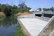
. The entire 3 miles (5 km) downtown stretch, from Interstate 280
to Interstate 880, is part of the Guadalupe River Park and Gardens, one of the largest urban parks currently in development in the United States. Also, the Guadalupe River Trail
runs along 11 miles (18 km) of the river bank.
on March 30, 1776, Rio de Nuestra Señora de Guadalupe, in honor of the Mexican saint who was the principal patron saint of the expedition. Specifically, Juan Bautista de Anza
camped along the banks of the Guadalupe River at Expedition Camp 97 on March 30, 1776 near the present–day site of Agnews State Hospital (Santa Clara County, 2001). The historic de Anza Expedition explored much of Santa Clara County, traversing western areas en route from Monterey
to San Francisco
, and traveling around the south end of San Francisco Bay and thence through the eastern portions of the county on the return trip after exploration of parts of the East Bay.
In 1777, the original Mission Santa Clara de Thamien
and el Pueblo de San José de Guadalupe were established on the banks of Mission Creek, un tiro de escopeta (a musket shot away) from its confluence with the Guadalupe River. Both had to be moved away from the river because of mosquitoes in the summertime and flooding during the winter. Today Santa Clara Mission is 2 miles (3.2 km) away from the original location.
On July 9, 2005, the fossilized bones of a juvenile Columbian Mammoth
were discovered in the Lower Guadalupe River near the Trimble Road overcrossing. The discovery was made by San Jose resident, founder of the Salmon and Steelhead Restoration Group and Guadalupe-Coyote Resource Conservation District volunteer Roger Castillo while walking his dog. The Pleistocene mammoth was nicknamed "Lupe" by area residents and Lupe's fossils are exhibited at Children's Discovery Museum of San Jose
.
 Historically, the Guadalupe River flowed into Guadalupe Slough, 1 miles (1.6 km) west of its current drainage into Alviso Slough. To make it easier to get sailboats up the Guadalupe River to the port of Alviso, the river was redirected into the straighter Alviso Slough by the 1870s. Alviso Slough, also known as Steamboat Slough historically, was relatively straight, while Guadalupe Slough meandered extensively through the marshes. Alviso Slough was historically not fed by any upland streams, but simply carried tidewater in and out of the extensive salt marshes.
The re-routing of the river to Alviso Slough in the 1870s also disconnected it from several tributaries, and had the effect of shrinking the Guadalupe River Watershed. San Tomas Aquino Creek
(current) and its Saratoga Creek
tributary (previously known as San Jon Creek and Campbell Creek) and Calabazas Creek
(historic), used to enter the Guadalupe River upstream of Alviso. These tributaries were disconnected from the river and re-routed directly into Guadalupe Slough between 1876 and 1890 according to historic maps. Reportedly, Saratoga Creek (Campbell Creek) had steelhead and coho salmon runs. Large portions of the tributaries of the river were straightened and armored starting in the late 19th century and continuing through the 20th century first by farmers and then by the Santa Clara Valley Water District
(SCVWD) and its predecessor organizations. They now go dry in the summer months and their lower segments have become denuded ditches requiring continuous maintenance. Mission Creek used to harbor trout and salmon but today it is buried in a culvert. The historic watershed can be viewed in the Thompson and West 1876 maps.
The Guadalupe Watershed
today drains an area of 171 square miles (442.9 km²). Below its origination at the confluence of Guadalupe Creek and Los Alamitos Creek
, the mainstem is joined by three other tributaries: Ross, Canoas, and Los Gatos
Creeks. The SCVWD manages water flows (supply) and provides flood control on the river, and recently has started to promote watershed stewardship. Six major reservoirs exist in the watershed: Calero Reservoir on Calero Creek, Guadalupe Reservoir
on Guadalupe Creek, Almaden Reservoir on Alamitos Creek, Vasona Reservoir
, Lexington Reservoir
, and Lake Elsman on Los Gatos Creek.
on the West Coast. When complete, the project should restore 15100 acres (61.1 km²) of industrial salt ponds to tidal wetlands. Pond A8 will be the first one worked on.
are extant in the river, making the Guadalupe River one of several major U. S. cities with known salmon spawning runs, including Anchorage, Alaska
; Seattle, Washington
; Portland, Oregon
and Sacramento, California
. Runs of up to 1,000 Chinook or King Salmon
(Oncorhynchus tshawytscha) swam up the Guadalupe River each fall in the 1990s, but have all but vanished in the current decade apparently blocked from access to breeding grounds by impassable culverts, weirs and overly wide, exposed and flat concrete paved channels installed by the SCVWD. By 2006 less than 40 King salmon were counted, although two managed to get up to Los Gatos that year and spawn below the California State Route 17 Freeway bridge over Los Gatos Creek
in back of the Pruneyard Shopping Center
. No Chinook have been seen until November, 2011 when they were documented with photo and video, the apparent offspring of the 2006 spawners.
Coho salmon
(Oncorhynchus kisutch) were observed in the Guadalupe River system by longtime local residents and anglers, made mostly between the 1920s to 1960s. The fact that there were multiple historical accounts, and that some were from individuals qualified to identify salmon, and based on the presence of continued suitable habitat conditions for Coho in the upper watershed, it has been determined that Coho were once extant. However, the good spawning habitat in the upper reaches have been blocked by the construction of multiple dams.
On the Los Gatos Creek
tributary a population of California Golden beavers (Castor canadensis subauratus) has been re-established between Lake Elsman and Lexington Reservoir
. The beaver were re-introduced to the portion of Los Gatos Creek where it enters Lexington Reservoir sometime prior to 1997, and recently, a beaver reportedly served as "a hearty meal" for a local mountain lion. Historical evidence of beaver in the area includes reference by Captain John Sutter
who around 1840 recorded that 1,500 beaver pelts were sold "at a trifling value" by the Indians to Mission San José. In 1840, from the port of Alviso, California, beaver pelts, cattle hides and tallow were shipped to San Francisco
. In addition, in 1828 fur trapper Michel La Framboise travelled from the Bonaventura River
to San Francisco and then the missions of San José, San Francisco Solano
and San Rafael Arcángel
. La Framboise stated that "the Bay of San
Francisco abounds in beaver", and that he "made his best hunt in the vicinity of the missions". Finally, the Smithsonian Institution
houses a Golden beaver skull collected by zoologist James Graham Cooper
in Santa Clara, California on Dec. 31, 1855. Golden beaver were apparently wiped out by trappers in the South Bay sometime after the end of the California Fur Rush
.
Caspian tern
s (Hydroprogne caspia), North America's largest tern, return to the Bay every spring to nest, migrating from as far away as Colombia
. According to scientists from the U.S. Geological Survey, Caspian tern populations in the South Bay are declining at the same time that high levels of mercury are being found in their eggs. The highest mercury levels found in animals from the Bay were in the eggs of Caspian and Forster
's (Sterna forsteri) terns that nest near the Cargill salt ponds at the mouth of the Guadalupe River. A study conducted by the U.S. Fish and Wildlife Service has found that nearly three-quarters of the eggs examined from black-crowned night heron
(Nycticorax nycticorax) nests in the Guadalupe watershed contained mercury exceeding thresholds known to kill the embryos of other bird species.
to declare a National Disaster Area in 1995 and 1997. In March 1995, flooding of this river around the San Jose Arena caused the cancellation of a San Jose Sharks
game, the only rainout in the history of the National Hockey League
. This flood, like most Guadalupe River floods, was triggered by undersized bridges, in this case the Julian Street Bridge.
The river has flooded 15 times since World War II. In response to this flooding, the Santa Clara Valley Water District
(SCVWD) launched a series of flood protection projects along the Guadalupe River to ensure that residential and commercial areas near the river are protected from 100-year floods. A major component of the flood control
project, designed to control a 100-year flood
along the Lower Guadalupe, was completed in late 2008. The greatest Guadalupe River flood on record occurred in 1955 and was part of the legendary "Christmas Week Floods" when the Guadalupe River flooded 8300 acres (33.6 km²).
was an area of intense activity during the California Gold Rush
, with the quicksilver mines within Santa Clara County supporting the gold refinement process. Thus, mercury toxicity and its effects on surrounding humans and wildlife is a major concern for the area. Because mercury
is an effective magnet for gold, miners during the Gold Rush would regularly line their sluices with Mercury to amalgamate the gold. An estimated 6,500 tons of mercury was lost in the system of creeks and rivers along the coast between 1850 and 1920, and is currently being detected today in the local streams, animal life, and riverbeds of these affected tributaries.
River
A river is a natural watercourse, usually freshwater, flowing towards an ocean, a lake, a sea, or another river. In a few cases, a river simply flows into the ground or dries up completely before reaching another body of water. Small rivers may also be called by several other names, including...
in California
California
California is a state located on the West Coast of the United States. It is by far the most populous U.S. state, and the third-largest by land area...
whose headwater creeks originate in the Santa Cruz Mountains
Santa Cruz Mountains
The Santa Cruz Mountains, part of the Pacific Coast Ranges, are a mountain range in central California, United States. They form a ridge along the San Francisco Peninsula, south of San Francisco, separating the Pacific Ocean from San Francisco Bay and the Santa Clara Valley, and continuing south,...
near the summit of Loma Prieta
Loma Prieta
Loma Prieta is a Northern California mountain located in the Santa Cruz Mountains. The peak is located on private property, about west of Morgan Hill and within the boundaries of Santa Clara County...
and Mount Umunhum
Mount Umunhum
Mount Umunhum is the fourth-highest peak in the Santa Cruz Mountains of California . The mountain is situated in Santa Clara County, southeast of Los Gatos and south of South San Jose...
. The river mainstem now begins on the Santa Clara Valley
Santa Clara Valley
The Santa Clara Valley is a valley just south of the San Francisco Bay in Northern California in the United States. Much of Santa Clara County and its county seat, San José, are in the Santa Clara Valley. The valley was originally known as the Valley of Heart’s Delight for its high concentration...
floor at the northern end of Lake Almaden, which is fed by Los Alamitos Creek
Los Alamitos Creek
Los Alamitos Creek or Alamitos Creek is a creek in San Jose, California, which becomes the Guadalupe River at its confluence with Guadalupe Creek at Lake Almaden Park. It is located in Almaden Valley and originates from the Los Capitancillos Ridge and the Santa Cruz Mountains...
and Guadalupe Creek, just downstream of Coleman Road in San Jose, California
San Jose, California
San Jose is the third-largest city in California, the tenth-largest in the U.S., and the county seat of Santa Clara County which is located at the southern end of San Francisco Bay...
. From here it flows north through San Jose, emptying into the San Francisco Bay
San Francisco Bay
San Francisco Bay is a shallow, productive estuary through which water draining from approximately forty percent of California, flowing in the Sacramento and San Joaquin rivers from the Sierra Nevada mountains, enters the Pacific Ocean...
at the Alviso Slough after a traverse of 14 miles (22.5 km). Historically the Guadalupe River was even shorter, originating several miles further north, at the downstream end of a large willow swamp that is now Willow Glen
Willow Glen, California
Willow Glen is a neighborhood of San Jose, California, in Santa Clara County. Geographically speaking, the Willow Glen neighborhood is centered around Lincoln Avenue, which was re-named from "Willow Glen Road" in 1865 shortly after the assassination of President Abraham Lincoln.By 1863 the small...
. Its main tributary was known as Arroyo Seco de Guadalupe on 1860 maps and then as Arroyo Seco de Los Capitancillos on the 1876 Thompson & West maps. The Guadalupe River runs through the City of San Jose, California, although it serves as the eastern boundary of the City of Santa Clara
Santa Clara, California
Santa Clara , founded in 1777 and incorporated in 1852, is a city in Santa Clara County, in the U.S. state of California. The city is the site of the eighth of 21 California missions, Mission Santa Clara de Asís, and was named after the mission. The Mission and Mission Gardens are located on the...
and the western boundary of Alviso.
Much of the river is surrounded by parks. The river's Los Alamitos and Guadalupe Creek tributaries are, in turn, fed by smaller streams flowing from Almaden Quicksilver County Park
Almaden Quicksilver County Park
Almaden Quicksilver County Park is a 4,147 acres park that includes the grounds of former mercury mines adjacent to south San Jose, California, USA...
, home to former mercury
Mercury (element)
Mercury is a chemical element with the symbol Hg and atomic number 80. It is also known as quicksilver or hydrargyrum...
mines dating back to when the area was governed by Mexico
Mexico
The United Mexican States , commonly known as Mexico , is a federal constitutional republic in North America. It is bordered on the north by the United States; on the south and west by the Pacific Ocean; on the southeast by Guatemala, Belize, and the Caribbean Sea; and on the east by the Gulf of...
. It is named after the New Almaden Quicksilver Mines
New Almaden
The New Almaden quicksilver mine in the Santa Teresa Hills in Santa Clara County, California, United States, is the oldest and most productive quicksilver mine in the U.S. The site was known to the Ohlone Indians for its cinnabar long before a Mexican settler discovered the ores in 1820...
, which were named after the mercury
Mercury (element)
Mercury is a chemical element with the symbol Hg and atomic number 80. It is also known as quicksilver or hydrargyrum...
mine
Mining
Mining is the extraction of valuable minerals or other geological materials from the earth, from an ore body, vein or seam. The term also includes the removal of soil. Materials recovered by mining include base metals, precious metals, iron, uranium, coal, diamonds, limestone, oil shale, rock...
in (old) Almadén
Almadén
Almadén, Spain, is a town and municipality in the province of Ciudad Real, within the autonomous community of Castile-La Mancha. The town is located at 4° 49' W and 38° 46' N and is 589 meters above sea level. Almadén is approximately 200 km south of Madrid in the Sierra Morena...
, Spain
Spain
Spain , officially the Kingdom of Spain languages]] under the European Charter for Regional or Minority Languages. In each of these, Spain's official name is as follows:;;;;;;), is a country and member state of the European Union located in southwestern Europe on the Iberian Peninsula...
, and produced mercury that was used to process ore during the Gold Rush
California Gold Rush
The California Gold Rush began on January 24, 1848, when gold was found by James W. Marshall at Sutter's Mill in Coloma, California. The first to hear confirmed information of the gold rush were the people in Oregon, the Sandwich Islands , and Latin America, who were the first to start flocking to...
. The entire 3 miles (5 km) downtown stretch, from Interstate 280
Interstate 280 (California)
Interstate 280 is a 57-mile long north–south Interstate Highway in the San Francisco Bay Area of Northern California. It connects San Jose and San Francisco, running along just to the west of the cities of San Francisco Peninsula for most of its route.I-280 from its northern end at King...
to Interstate 880, is part of the Guadalupe River Park and Gardens, one of the largest urban parks currently in development in the United States. Also, the Guadalupe River Trail
Guadalupe River Trail
The Guadalupe River Trail is an pedestrian and bicycle path in the city of San Jose, California. The path runs along the banks of the Guadalupe River. The trail is currently composed of two discontinuous segments...
runs along 11 miles (18 km) of the river bank.
History
The Guadalupe River was named by the De Anza ExpeditionJuan Bautista de Anza
Juan Bautista de Anza Bezerra Nieto was a Novo-Spanish explorer and Governor of New Mexico for the Spanish Empire.-Early life:...
on March 30, 1776, Rio de Nuestra Señora de Guadalupe, in honor of the Mexican saint who was the principal patron saint of the expedition. Specifically, Juan Bautista de Anza
Juan Bautista de Anza
Juan Bautista de Anza Bezerra Nieto was a Novo-Spanish explorer and Governor of New Mexico for the Spanish Empire.-Early life:...
camped along the banks of the Guadalupe River at Expedition Camp 97 on March 30, 1776 near the present–day site of Agnews State Hospital (Santa Clara County, 2001). The historic de Anza Expedition explored much of Santa Clara County, traversing western areas en route from Monterey
Monterey, California
The City of Monterey in Monterey County is located on Monterey Bay along the Pacific coast in Central California. Monterey lies at an elevation of 26 feet above sea level. As of the 2010 census, the city population was 27,810. Monterey is of historical importance because it was the capital of...
to San Francisco
San Francisco, California
San Francisco , officially the City and County of San Francisco, is the financial, cultural, and transportation center of the San Francisco Bay Area, a region of 7.15 million people which includes San Jose and Oakland...
, and traveling around the south end of San Francisco Bay and thence through the eastern portions of the county on the return trip after exploration of parts of the East Bay.
In 1777, the original Mission Santa Clara de Thamien
Mission Santa Clara de Asís
Mission Santa Clara de Asís was founded on January 12, 1777 and named for Santa Clara de Asis , the foundress of the order of the Poor Clares. Although ruined and rebuilt six times, the settlement was never abandoned.-History:...
and el Pueblo de San José de Guadalupe were established on the banks of Mission Creek, un tiro de escopeta (a musket shot away) from its confluence with the Guadalupe River. Both had to be moved away from the river because of mosquitoes in the summertime and flooding during the winter. Today Santa Clara Mission is 2 miles (3.2 km) away from the original location.
On July 9, 2005, the fossilized bones of a juvenile Columbian Mammoth
Columbian Mammoth
The Columbian Mammoth is an extinct species of elephant of the Quaternary period that appeared in North America during the late Pleistocene. It is believed by some authorities to be the same species as its slightly larger cousin, M...
were discovered in the Lower Guadalupe River near the Trimble Road overcrossing. The discovery was made by San Jose resident, founder of the Salmon and Steelhead Restoration Group and Guadalupe-Coyote Resource Conservation District volunteer Roger Castillo while walking his dog. The Pleistocene mammoth was nicknamed "Lupe" by area residents and Lupe's fossils are exhibited at Children's Discovery Museum of San Jose
Children's Discovery Museum of San Jose
Children's Discovery Museum of San Jose is located on Woz Way in downtown San Jose, California. Woz Way is named after Steve Wozniak, co-founder of Apple Computer, whose nickname is "Woz," and who was the single largest private donor during the original capital campaign that funded the...
.
Guadalupe River Watershed
The re-routing of the river to Alviso Slough in the 1870s also disconnected it from several tributaries, and had the effect of shrinking the Guadalupe River Watershed. San Tomas Aquino Creek
San Tomas Aquino Creek
San Tomas Aquinas Creek, known locally as San Tomas Aquino Creek, is a stream that heads on El Sereno mountain in El Sereno Open Space Preserve in Saratoga, California in Santa Clara County, California, United States...
(current) and its Saratoga Creek
Saratoga Creek
Saratoga Creek is a north-northeast flowing creek in Santa Clara County, California.-History:Saratoga Creek was originally called Arroyo Quito and then Campbell Creek after immigrant William Campbell, who operated a sawmill in 1848 in "Campbell's Redwoods" about three miles west of Saratoga,...
tributary (previously known as San Jon Creek and Campbell Creek) and Calabazas Creek
Calabazas Creek (Santa Clara County)
Calabazas Creek is a northeast by northward-flowing stream originating on Table Mountain in Saratoga, California in Santa Clara County, California, United States...
(historic), used to enter the Guadalupe River upstream of Alviso. These tributaries were disconnected from the river and re-routed directly into Guadalupe Slough between 1876 and 1890 according to historic maps. Reportedly, Saratoga Creek (Campbell Creek) had steelhead and coho salmon runs. Large portions of the tributaries of the river were straightened and armored starting in the late 19th century and continuing through the 20th century first by farmers and then by the Santa Clara Valley Water District
Santa Clara Valley Water District
The Santa Clara Valley Water District provides stream stewardship, wholesale water supply and flood protection for Santa Clara County, California, in the southern San Francisco Bay Area. The district encompasses all of the county’s and serves the area’s 15 cities, 1.7 million residents and more...
(SCVWD) and its predecessor organizations. They now go dry in the summer months and their lower segments have become denuded ditches requiring continuous maintenance. Mission Creek used to harbor trout and salmon but today it is buried in a culvert. The historic watershed can be viewed in the Thompson and West 1876 maps.
The Guadalupe Watershed
Guadalupe Watershed
The Guadalupe Watershed consists of of land within northern California's Santa Clara County. This watershed is owned and managed by the Santa Clara Valley Water District...
today drains an area of 171 square miles (442.9 km²). Below its origination at the confluence of Guadalupe Creek and Los Alamitos Creek
Los Alamitos Creek
Los Alamitos Creek or Alamitos Creek is a creek in San Jose, California, which becomes the Guadalupe River at its confluence with Guadalupe Creek at Lake Almaden Park. It is located in Almaden Valley and originates from the Los Capitancillos Ridge and the Santa Cruz Mountains...
, the mainstem is joined by three other tributaries: Ross, Canoas, and Los Gatos
Los Gatos Creek (Santa Clara County, California)
The Los Gatos Creek runs 24 miles in California through Santa Clara Valley Water District's Guadalupe Watershed from the Santa Cruz Mountains northward through the Santa Clara Valley until its confluence with the Guadalupe River in downtown San Jose...
Creeks. The SCVWD manages water flows (supply) and provides flood control on the river, and recently has started to promote watershed stewardship. Six major reservoirs exist in the watershed: Calero Reservoir on Calero Creek, Guadalupe Reservoir
Guadalupe Reservoir
Guadalupe Reservoir is a reservoir in Santa Clara County, California, about east of the city of San Jose, California. It is at an elevation of . It has a capacity of . The dam is located on the Guadalupe River adjacent to Hicks Road...
on Guadalupe Creek, Almaden Reservoir on Alamitos Creek, Vasona Reservoir
Vasona Park
Vasona Park, formerly Vasona Lake County Park, is a park located in Los Gatos, California and part of the Santa Clara County Parks system. Adjacent Oak Meadow Park is owned by the Town of Los Gatos. Vasona Park surrounds Vasona Reservoir, which, like Lexington Reservoir in Los Gatos' southern edge,...
, Lexington Reservoir
Lexington Reservoir
Lexington Reservoir is an artificial lake on the Los Gatos Creek near Los Gatos, California. The James J. Lenihan Dam, a high, thick earthen dam, forms the third-largest reservoir in Santa Clara County.-Background:...
, and Lake Elsman on Los Gatos Creek.
Restoration of the River Mouth
Ending nine years of study and passionate debate about the future of the San Jose/Alviso waterfront, the Santa Clara Valley Water District in November, 2009 voted to approve a $6 million project to clear bulrushes, tule reeds and thick sediment from the Guadalupe River in Alviso. The construction of salt evaporation ponds in the 1930s rerouted the Guadalupe River, cutting off tidal action. Later, in the 1960s, as Alviso was being annexed into San Jose, the Army Corps of Engineers and the water district straightened the river to improve flood safety, which inadvertently increased sedimentation into Alviso Slough. The current project will open a former Cargill Salt pond (known as A8) as the beginning of the South Bay Salt Pond Restoration Project, considered the largest tidal wetland restoration projecton the West Coast. When complete, the project should restore 15100 acres (61.1 km²) of industrial salt ponds to tidal wetlands. Pond A8 will be the first one worked on.
Habitat and Wildlife
Early written documents record the local presence of migrating salmon in the ‘'Rio Guadalupe'’ dating as far back as the 18th century. Both steelhead trout (Oncorhynchus mykiss) and King salmonChinook salmon
The Chinook salmon, Oncorhynchus tshawytscha, is the largest species in the pacific salmon family. Other commonly used names for the species include King salmon, Quinnat salmon, Spring salmon and Tyee salmon...
are extant in the river, making the Guadalupe River one of several major U. S. cities with known salmon spawning runs, including Anchorage, Alaska
Anchorage, Alaska
Anchorage is a unified home rule municipality in the southcentral part of the U.S. state of Alaska. It is the northernmost major city in the United States...
; Seattle, Washington
Seattle, Washington
Seattle is the county seat of King County, Washington. With 608,660 residents as of the 2010 Census, Seattle is the largest city in the Northwestern United States. The Seattle metropolitan area of about 3.4 million inhabitants is the 15th largest metropolitan area in the country...
; Portland, Oregon
Portland, Oregon
Portland is a city located in the Pacific Northwest, near the confluence of the Willamette and Columbia rivers in the U.S. state of Oregon. As of the 2010 Census, it had a population of 583,776, making it the 29th most populous city in the United States...
and Sacramento, California
Sacramento, California
Sacramento is the capital city of the U.S. state of California and the county seat of Sacramento County. It is located at the confluence of the Sacramento River and the American River in the northern portion of California's expansive Central Valley. With a population of 466,488 at the 2010 census,...
. Runs of up to 1,000 Chinook or King Salmon
Chinook salmon
The Chinook salmon, Oncorhynchus tshawytscha, is the largest species in the pacific salmon family. Other commonly used names for the species include King salmon, Quinnat salmon, Spring salmon and Tyee salmon...
(Oncorhynchus tshawytscha) swam up the Guadalupe River each fall in the 1990s, but have all but vanished in the current decade apparently blocked from access to breeding grounds by impassable culverts, weirs and overly wide, exposed and flat concrete paved channels installed by the SCVWD. By 2006 less than 40 King salmon were counted, although two managed to get up to Los Gatos that year and spawn below the California State Route 17 Freeway bridge over Los Gatos Creek
Los Gatos Creek (Santa Clara County, California)
The Los Gatos Creek runs 24 miles in California through Santa Clara Valley Water District's Guadalupe Watershed from the Santa Cruz Mountains northward through the Santa Clara Valley until its confluence with the Guadalupe River in downtown San Jose...
in back of the Pruneyard Shopping Center
Pruneyard Shopping Center
The PruneYard Shopping Center is a sprawling 250,000 square foot shopping center located in Campbell, California at the intersection of Campbell Avenue and Bascom Avenue, just east of State Route 17. It also features three office towers, one of which is the tallest building in the area outside of...
. No Chinook have been seen until November, 2011 when they were documented with photo and video, the apparent offspring of the 2006 spawners.
Coho salmon
Coho salmon
The Coho salmon, Oncorhynchus kisutch, is a species of anadromous fish in the salmon family. Coho salmon are also known as silver salmon or "silvers". It is the state animal of Chiba, Japan.-Description:...
(Oncorhynchus kisutch) were observed in the Guadalupe River system by longtime local residents and anglers, made mostly between the 1920s to 1960s. The fact that there were multiple historical accounts, and that some were from individuals qualified to identify salmon, and based on the presence of continued suitable habitat conditions for Coho in the upper watershed, it has been determined that Coho were once extant. However, the good spawning habitat in the upper reaches have been blocked by the construction of multiple dams.
On the Los Gatos Creek
Los Gatos Creek (Santa Clara County, California)
The Los Gatos Creek runs 24 miles in California through Santa Clara Valley Water District's Guadalupe Watershed from the Santa Cruz Mountains northward through the Santa Clara Valley until its confluence with the Guadalupe River in downtown San Jose...
tributary a population of California Golden beavers (Castor canadensis subauratus) has been re-established between Lake Elsman and Lexington Reservoir
Lexington Reservoir
Lexington Reservoir is an artificial lake on the Los Gatos Creek near Los Gatos, California. The James J. Lenihan Dam, a high, thick earthen dam, forms the third-largest reservoir in Santa Clara County.-Background:...
. The beaver were re-introduced to the portion of Los Gatos Creek where it enters Lexington Reservoir sometime prior to 1997, and recently, a beaver reportedly served as "a hearty meal" for a local mountain lion. Historical evidence of beaver in the area includes reference by Captain John Sutter
John Sutter
Johann Augus Sutter was a Swiss pioneer of California known for his association with the California Gold Rush by the discovery of gold by James W. Marshall and the mill making team at Sutter's Mill, and for establishing Sutter's Fort in the area that would eventually become Sacramento, the...
who around 1840 recorded that 1,500 beaver pelts were sold "at a trifling value" by the Indians to Mission San José. In 1840, from the port of Alviso, California, beaver pelts, cattle hides and tallow were shipped to San Francisco
San Francisco, California
San Francisco , officially the City and County of San Francisco, is the financial, cultural, and transportation center of the San Francisco Bay Area, a region of 7.15 million people which includes San Jose and Oakland...
. In addition, in 1828 fur trapper Michel La Framboise travelled from the Bonaventura River
Sacramento River
The Sacramento River is an important watercourse of Northern and Central California in the United States. The largest river in California, it rises on the eastern slopes of the Klamath Mountains, and after a journey south of over , empties into Suisun Bay, an arm of the San Francisco Bay, and...
to San Francisco and then the missions of San José, San Francisco Solano
Mission San Francisco Solano
Mission San Francisco Solano was founded on July 4, 1823, and named for Francis Solanus, a missionary to the Indians of Peru born in Montilla, Spain, known as the "Wonder Worker of the New World." Originally planned as an asistencia to Mission San Rafael Arcángel, it is the northernmost Alta...
and San Rafael Arcángel
Mission San Rafael Arcángel
Mission San Rafael Arcángel was founded in 1817 as a medical asistencia of the Mission San Francisco de Asís as a hospital to treat sick Native Americans of the Bay Area, making it Alta California's first sanitarium. The weather was much better in the North Bay than in San Francisco, and helped...
. La Framboise stated that "the Bay of San
Francisco abounds in beaver", and that he "made his best hunt in the vicinity of the missions". Finally, the Smithsonian Institution
Smithsonian Institution
The Smithsonian Institution is an educational and research institute and associated museum complex, administered and funded by the government of the United States and by funds from its endowment, contributions, and profits from its retail operations, concessions, licensing activities, and magazines...
houses a Golden beaver skull collected by zoologist James Graham Cooper
James Graham Cooper
James Graham Cooper was an American surgeon and naturalist.Cooper was born in New York. He worked for the California Geological Survey with Josiah Dwight Whitney, William Henry Brewer and Henry Nicholas Bolander...
in Santa Clara, California on Dec. 31, 1855. Golden beaver were apparently wiped out by trappers in the South Bay sometime after the end of the California Fur Rush
California Fur Rush
Before the 1849 California Gold Rush, American, English and Russian fur hunters were drawn to Spanish California in a California Fur Rush, to exploit its enormous fur resources...
.
Caspian tern
Caspian Tern
The Caspian Tern is a species of tern, with a subcosmopolitan but scattered distribution. Despite its extensive range, it is monotypic of its genus, and has no subspecies accepted either...
s (Hydroprogne caspia), North America's largest tern, return to the Bay every spring to nest, migrating from as far away as Colombia
Colombia
Colombia, officially the Republic of Colombia , is a unitary constitutional republic comprising thirty-two departments. The country is located in northwestern South America, bordered to the east by Venezuela and Brazil; to the south by Ecuador and Peru; to the north by the Caribbean Sea; to the...
. According to scientists from the U.S. Geological Survey, Caspian tern populations in the South Bay are declining at the same time that high levels of mercury are being found in their eggs. The highest mercury levels found in animals from the Bay were in the eggs of Caspian and Forster
Forster's Tern
The Forster's Tern, Sterna forsteri, is a member of the tern family Sternidae. It breeds inland in North America and winters south to the Caribbean and northern South America....
's (Sterna forsteri) terns that nest near the Cargill salt ponds at the mouth of the Guadalupe River. A study conducted by the U.S. Fish and Wildlife Service has found that nearly three-quarters of the eggs examined from black-crowned night heron
Black-crowned Night Heron
The Black-crowned Night Heron commonly abbreviated to just Night Heron in Eurasia, is a medium-sized heron found throughout a large part of the world, except in the coldest regions and Australasia .-Description:Adults are...
(Nycticorax nycticorax) nests in the Guadalupe watershed contained mercury exceeding thresholds known to kill the embryos of other bird species.
Flooding
The river occasionally floods in downtown San Jose, south of downtown, as well as in Alviso. Flooding prompted President ClintonBill Clinton
William Jefferson "Bill" Clinton is an American politician who served as the 42nd President of the United States from 1993 to 2001. Inaugurated at age 46, he was the third-youngest president. He took office at the end of the Cold War, and was the first president of the baby boomer generation...
to declare a National Disaster Area in 1995 and 1997. In March 1995, flooding of this river around the San Jose Arena caused the cancellation of a San Jose Sharks
San Jose Sharks
The San Jose Sharks are a professional ice hockey team based in San Jose, California, United States. They are members of the Pacific Division of the Western Conference of the National Hockey League...
game, the only rainout in the history of the National Hockey League
National Hockey League
The National Hockey League is an unincorporated not-for-profit association which operates a major professional ice hockey league of 30 franchised member clubs, of which 7 are currently located in Canada and 23 in the United States...
. This flood, like most Guadalupe River floods, was triggered by undersized bridges, in this case the Julian Street Bridge.
The river has flooded 15 times since World War II. In response to this flooding, the Santa Clara Valley Water District
Santa Clara Valley Water District
The Santa Clara Valley Water District provides stream stewardship, wholesale water supply and flood protection for Santa Clara County, California, in the southern San Francisco Bay Area. The district encompasses all of the county’s and serves the area’s 15 cities, 1.7 million residents and more...
(SCVWD) launched a series of flood protection projects along the Guadalupe River to ensure that residential and commercial areas near the river are protected from 100-year floods. A major component of the flood control
Flood control
In communications, flood control is a feature of many communication protocols designed to prevent overwhelming of a destination receiver. Such controls can be implemented either in software or in hardware, and will often request that the message be resent after the receiver has finished...
project, designed to control a 100-year flood
100-year flood
A one-hundred-year flood is calculated to be the level of flood water expected to be equaled or exceeded every 100 years on average. The 100-year flood is more accurately referred to as the 1% annual exceedance probability flood, since it is a flood that has a 1% chance of being equaled or exceeded...
along the Lower Guadalupe, was completed in late 2008. The greatest Guadalupe River flood on record occurred in 1955 and was part of the legendary "Christmas Week Floods" when the Guadalupe River flooded 8300 acres (33.6 km²).
Mercury Contamination
The Guadalupe WatershedGuadalupe Watershed
The Guadalupe Watershed consists of of land within northern California's Santa Clara County. This watershed is owned and managed by the Santa Clara Valley Water District...
was an area of intense activity during the California Gold Rush
California Gold Rush
The California Gold Rush began on January 24, 1848, when gold was found by James W. Marshall at Sutter's Mill in Coloma, California. The first to hear confirmed information of the gold rush were the people in Oregon, the Sandwich Islands , and Latin America, who were the first to start flocking to...
, with the quicksilver mines within Santa Clara County supporting the gold refinement process. Thus, mercury toxicity and its effects on surrounding humans and wildlife is a major concern for the area. Because mercury
Mercury (element)
Mercury is a chemical element with the symbol Hg and atomic number 80. It is also known as quicksilver or hydrargyrum...
is an effective magnet for gold, miners during the Gold Rush would regularly line their sluices with Mercury to amalgamate the gold. An estimated 6,500 tons of mercury was lost in the system of creeks and rivers along the coast between 1850 and 1920, and is currently being detected today in the local streams, animal life, and riverbeds of these affected tributaries.
External links
- Santa Clara County, California: Historic and Interpretive Sites (2001)
- Guadalupe Watershed Projects Page
- Guadalupe River Watershed, Guide to San Francisco Bay Area Creeks
- Guadalupe River Park Conservancy's website
- Fish ladder on Guadalupe River promises hope for salmon and steelhead recovery
- Guadalupe River water level
- Guadalupe - Coyote Resource Conservation District
- Santa Clara Basin Watershed Management Initiative (WMI)