This is a list of countries by length of coastline, in kilometers, based on data for the year 2008 by the CIA World Factbook. A coastline of zero indicates that the country is
landlockedA landlocked country is a country entirely enclosed by land, or whose only coastlines lie on closed seas. There are 48 landlocked countries in the world, including partially recognized states...
.
The
coastline paradoxThe coastline paradox is the counterintuitive observation that the coastline of a landmass does not have a well-defined length. This results from the fractal-like properties of coastlines. It was first observed by Lewis Fry Richardson....
states that a coastline does not have a well-defined length. Measurements of the
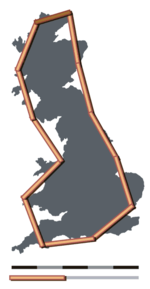
length of a coastline"How Long Is the Coast of Britain? Statistical Self-Similarity and Fractional Dimension" is a paper by mathematician Benoît Mandelbrot, first published in Science in 1967. In this paper Mandelbrot discusses self-similar curves that have Hausdorff dimension between 1 and 2...
behave like a
fractalA fractal has been defined as "a rough or fragmented geometric shape that can be split into parts, each of which is a reduced-size copy of the whole," a property called self-similarity...
, being different at different scale intervals (distance between points on the coastline at which measurements are taken). The smaller the scale interval (meaning the more detailed the measurement), the longer the coastline will be.
[The smaller the scale interval mathematically, the more detailed and the 'greater the scale of the map', in common usage. See scale (map)]The scale of a map is defined as the ratio of a distance on the map to the corresponding distance on the ground.If the region of the map is small enough for the curvature of the Earth to be neglected, then the scale may be taken as a constant ratio over the whole map....
. This 'magnifying' effect is greater for convoluted coastlines than for relatively smooth ones. For example, as seen on satellite image websites, the length of
CanadaCanada is a North American country consisting of ten provinces and three territories. Located in the northern part of the continent, it extends from the Atlantic Ocean in the east to the Pacific Ocean in the west, and northward into the Arctic Ocean...
's very convoluted coastline at a scale interval of 500 km is only about 20,000 km, less than a tenth of the value given in the table. On the other hand,
AustraliaAustralia , officially the Commonwealth of Australia, is a country in the Southern Hemisphere comprising the mainland of the Australian continent, the island of Tasmania, and numerous smaller islands in the Indian and Pacific Oceans. It is the world's sixth-largest country by total area...
's coastline at 500 km intervals is about 12,500 km, around half the value in the table.
The coast/area ratio measures how many meters of coastline correspond to every square kilometer of land area. The ratio illustrates the ease of accessibility to the country's coast from every point in its interior. Therefore, an
island country like
MaldivesThe Maldives , , officially Republic of Maldives , also referred to as the Maldive Islands, is an island nation in the Indian Ocean formed by a double chain of twenty-six atolls oriented north-south off India's Lakshadweep islands, between Minicoy Island and...
, or a country carved by the sea like
GreeceGreece , officially the Hellenic Republic , and historically Hellas or the Republic of Greece in English, is a country in southeastern Europe....
, is more likely to have a high ratio, while a
landlockedA landlocked country is a country entirely enclosed by land, or whose only coastlines lie on closed seas. There are 48 landlocked countries in the world, including partially recognized states...
country like
AustriaAustria , officially the Republic of Austria , is a landlocked country of roughly 8.4 million people in Central Europe. It is bordered by the Czech Republic and Germany to the north, Slovakia and Hungary to the east, Slovenia and Italy to the south, and Switzerland and Liechtenstein to the...
will have a ratio of zero.
TokelauTokelau is a territory of New Zealand in the South Pacific Ocean that consists of three tropical coral atolls with a combined land area of 10 km2 and a population of approximately 1,400...
has the highest ratio (10,100.000); the
Democratic Republic of the CongoThe Democratic Republic of the Congo is a state located in Central Africa. It is the second largest country in Africa by area and the eleventh largest in the world...
has the lowest nonzero ratio (0.016). Of countries without land borders,
AustraliaAustralia , officially the Commonwealth of Australia, is a country in the Southern Hemisphere comprising the mainland of the Australian continent, the island of Tasmania, and numerous smaller islands in the Indian and Pacific Oceans. It is the world's sixth-largest country by total area...
has the lowest ratio (3.381).
Note that the scales at which the CIA World Factbook figures were measured are not stated, nor is it known whether the figures are all reported using the same scale, thus the figures are not necessarily comparable across different countries.
| rank |
territory |
land area
(km²) |
coastline
(km) |
coast/area ratio
(m/km²) |
| |
|
148,940,000 |
356,000 |
|
| 1 |
|
9,093,507 |
202,080 |
|
| 2 |
|
1,811,569 |
54,716 |
|
| |
 Greenland Greenland[Greenland is an autonomous]An autonomous area or autonomous entity is an area of a country that has a degree of autonomy, or freedom from an external authority. Typically it is either geographically distinct from the rest of the country or populated by a national minority. Countries that include autonomous areas are often...
countryConstituent country is a phrase sometimes used in contexts in which a country makes up a part of a larger entity. The term constituent country does not have any defined legal meaning, and is used simply to refer to a country which is a part Constituent country is a phrase sometimes used in contexts...
within DenmarkThe Kingdom of Denmark or the Danish Realm , is a constitutional monarchy and sovereign state consisting of Denmark proper in northern Europe and two autonomous constituent countries, the Faroe Islands in the North Atlantic and Greenland in North America. Denmark is the hegemonial part, where the...
. |
2,166,086 |
44,087 |
|
| 3 |
|
16,377,742 |
37,653 |
|
| 4 |
|
298,170 |
36,289 |
|
| 5 |
|
364,485 |
29,751 |
|
| 6 |
|
7,682,300 |
25,760 |
|
| 7 |
|
304,282 |
25,148[According to the Norwegian Mapping Authority (NMA) the norwegian coastline including fjords and islands the total length is as much as 100,915 km. See NMAs article (norwegian) here.] |
|
| 8 |
|
9,161,966 |
19,924 |
|
| |
 Antarctica Antarctica |
14,000,000 |
17,968 |
|
| 9 |
|
267,710 |
15,134 |
|
| 10 |
|
9,569,901 |
14,500 |
|
| 11 |
|
130,647 |
13,676 |
|
| 12 |
|
241,930 |
13,400 |
|
| 13 |
|
1,943,945 |
9,330 |
|
| 14 |
|
294,140 |
7,600 |
26 |
| 15 |
|
8,459,417 |
7,491 |
|
| 16 |
|
42,434 |
7,314 |
|
| 17 |
|
769,632 |
7,200 |
|
| 18 |
|
2,973,193 |
7,000 |
2 |
| 19 |
|
743,812 |
6,435 |
|
| 20 |
|
702 |
6,112 |
8,710 |
| 21 |
|
55,974 |
5,835 |
|
| 22 |
|
27,986 |
5,313 |
|
| 23 |
|
452,860 |
5,152 |
|
| 24 |
|
2,736,690 |
4,989 |
|
| 25 |
|
100,250 |
4,970 |
|
| 26 |
|
498,980 |
4,964 |
|
| 27 |
[Data includes Metropolitan France]Metropolitan France is the part of France located in Europe. It can also be described as mainland France or as the French mainland and the island of Corsica...
and the five overseas regions. |
640,427 |
4,853 |
|
| 28 |
|
581,540 |
4,828 |
|
| 29 |
|
328,657 |
4,675 |
|
| 30 |
|
42,388 |
3,794 |
|
| 31 |
|
109,820 |
3,735 |
|
| |
 Svalbard Svalbard |
62,045 |
3,587 |
|
| 32 |
|
10,010 |
3,542 |
|
| 33 |
|
310,070 |
3,444[Excludes minor outlying islands.] |
|
| 34 |
|
510,890 |
3,219 |
|
| 35 |
|
410,335 |
3,218 |
|
| 36 |
|
1,038,700 |
3,208 |
|
| |
 Coral Sea Islands Coral Sea Islands |
<3 |
3,095 |
1,030,000>1,000,000 |
| 37 |
|
627,337 |
3,025 |
|
| |
 French Southern Territories French Southern Territories |
|
[Does not include Ile Saint-Paul]Île Saint-Paul is an island forming part of the French Southern and Antarctic Lands in the Indian Ocean, with an area of . It is located about southwest of the larger Île Amsterdam, and south of Réunion...
and Iles Crozet (data unavailable) or Adelie LandAdélie Land is the portion of the Antarctic coast between 136° E and 142° E , with a shore length of 350 km and with its hinterland extending as a sector about 2,600 km toward the South Pole. It is claimed by France as one of five districts of the French Southern and Antarctic Lands, although not...
claim to antarctica. |
400 |
| 38 |
|
882,050 |
2,800 |
|
| 39 |
|
1,214,470 |
2,798 |
|
| 40 |
|
579,330 |
2,782 |
|
| 41 |
|
2,149,690 |
2,640 |
|
| 42 |
|
12,189 |
2,528 |
|
| |
 French Polynesia French Polynesia |
3,827 |
2,525 |
|
| 43 |
|
120,408 |
2,495 |
|
| 44 |
|
74,340 |
2,490 |
|
| 45 |
|
786,380 |
2,470 |
|
| 46 |
|
995,450 |
2,450 |
|
| 47 |
|
1,531,595 |
2,440[Iran has an additional 740 km of coastline along the Caspian Sea, which is landlocked.] |
|
| 48 |
|
1,279,996 |
2,414 |
|
| 49 |
|
96,920 |
2,413 |
|
| 50 |
|
348,672 |
2,389 |
|
| |
 New Caledonia New Caledonia |
18,275 |
2,254 |
|
| 51 |
|
276,841 |
2,237 |
|
| 52 |
|
101,000 |
2,234 |
|
| 53 |
|
309,500 |
2,092 |
|
| 54 |
|
653,508 |
1,930 |
|
| 55 |
|
527,968 |
1,906 |
|
| 56 |
|
446,300 |
1,835 |
|
| 57 |
|
91,470 |
1,793 |
|
| 58 |
|
27,560 |
1,771 |
|
| 59 |
|
1,759,540 |
1,770 |
|
| 60 |
|
1,246,700 |
1,600 |
|
| 61 |
|
823,290 |
1,572 |
|
| 62 |
|
32,260 |
|
|
| 63 |
|
459 |
1,519 |
3,310 |
| |
 Northern Mariana Islands Northern Mariana Islands |
464 |
1,482 |
3,190 |
| 64 |
|
68,883 |
1,448 |
|
| 65 |
|
885,800 |
1,424 |
|
| 66 |
|
64,630 |
1,340 |
|
| 67 |
|
83,600 |
1,318 |
|
| 68 |
|
51,060 |
1,290 |
|
| 69 |
|
48,320 |
1,288 |
|
| |
 Falkland Islands Falkland Islands |
12,173 |
1,288 |
|
| 70 |
|
303,815 |
1,250 |
|
| 71 |
|
155,360 |
1,148 |
|
| 72 |
|
811 |
1,143 |
1,410 |
| 73 |
|
18,274 |
1,129 |
|
| |
 Faroe Islands Faroe Islands |
1,393 |
1,117 |
|
| |
 Western Sahara Western Sahara |
266,000 |
1,110 |
|
| 74 |
|
770,875 |
1,046 |
|
| 75 |
|
10,831 |
1,022 |
|
| 76 |
|
2,381,741 |
998 |
|
| 77 |
|
4,033 |
965 |
239 |
| |
|
<5 |
926 |
190,000≥200,000 |
| 78 |
|
119,990 |
910 |
|
| 79 |
|
257,667 |
885 |
|
| 80 |
|
910,768 |
853 |
|
| 80 |
|
1,861,484 |
853 |
|
| 82 |
|
111,890 |
832[Includes coastline in the Gulf of Fonseca]The Gulf of Fonseca , part of the Pacific Ocean, is a gulf in Central America, bordering El Salvador, Honduras and Nicaragua.-History:Fonseca Bay was discovered in 1522 by Gil Gonzalez de Avila, and named by him after his patron, Archbishop Juan Fonseca, the implacable enemy of Columbus.In 1849, E. G...
(163 km). |
|
| 83 |
|
1,030,700 |
754 |
|
| |
[Hong Kong is a special administrative region of the People's Republic of China] |
1,054 |
733 |
695 |
| 84 |
|
14,874 |
706 |
|
| |
 British Indian Ocean Territory British Indian Ocean Territory |
60 |
698 |
10,000 |
| 85 |
|
175,015 |
660 |
|
| 86 |
|
9,241 |
648 |
|
| 87 |
|
298 |
644 |
2,160 |
| 88 |
|
130,168 |
580 |
|
| 89 |
|
96,320 |
579 |
|
| 90 |
|
11,586 |
563 |
|
| 91 |
|
227,533 |
539 |
|
| 92 |
|
569,140 |
536 |
|
| 93 |
|
192,530 |
531 |
|
| |
|
|
518 |
66,800 |
| 94 |
|
318,003 |
515 |
|
| |
 Puerto Rico Puerto Rico |
8,870 |
501 |
|
| 95 |
|
17,818 |
499 |
|
| 96 |
|
62,249 |
498 |
|
| 97 |
|
455 |
491 |
1,080 |
| 98 |
|
196,849 |
459 |
|
| 99 |
|
33,893 |
451[In 1900, the Dutch coastline measured approximately 1400 km. It has significantly been reduced by the closing of the Zuiderzee by the Afsluitdijk]The Afsluitdijk is a major causeway in the Netherlands, constructed between 1927 and 1933 and running from Den Oever on Wieringen in North Holland province, to the village of Zurich in Friesland province, over a length of and a width of 90 m, at an initial height of 7.25 m above sea-level.It is...
in 1932 (250 km) and the closing of several sea arms by the Delta WorksThe Delta Works is a series of construction projects in the southwest of the Netherlands to protect a large area of land around the Rhine-Meuse-Scheldt delta from the sea. The works consist of dams, sluices, locks, dikes, levees, and storm surge barriers...
(700 km). |
|
| 100 |
|
176,515 |
443 |
|
| 101 |
|
304,255 |
440 |
|
| 102 |
|
717 |
419 |
584 |
| 103 |
|
2,821 |
403 |
143 |
| 104 |
|
469,440 |
402 |
|
| 104 |
|
71,620 |
402 |
|
| 106 |
|
107,159 |
400 |
4 |
| |
 Turks and Caicos Islands Turks and Caicos Islands |
948 |
389 |
410 |
| 107 |
|
22,806 |
386 |
|
| 107 |
|
156,000 |
386 |
|
| 109 |
|
181 |
|
2,050 |
| |
 Curaçao Curaçao |
444 |
364 |
820 |
| 110 |
|
27,398 |
362 |
|
| 110 |
|
5,128 |
362 |
|
| 112 |
|
108,489 |
354 |
|
| 113 |
|
28,120 |
350 |
12 |
| 114 |
[Figures include Mayotte]Mayotte is an overseas department and region of France consisting of a main island, Grande-Terre , a smaller island, Petite-Terre , and several islets around these two. The archipelago is located in the northern Mozambique Channel in the Indian Ocean, namely between northwestern Madagascar and...
, which is administered by France. |
2,235 |
340 |
150 |
| 115 |
|
245,717 |
320 |
|
| 116 |
|
23,180 |
314 |
|
| 117 |
|
69,700 |
310 |
|
| 118 |
|
20,721 |
307 |
|
| 119 |
|
28,051 |
296 |
|
| 120 |
|
13,452 |
|
|
| 121 |
|
20,330 |
273 |
|
| 122 |
|
10,230 |
225 |
|
| 122 |
|
229,891 |
225 |
|
| 124 |
|
964 |
209 |
217 |
| 125 |
|
316 |
|
800 |
| 126 |
|
687 |
193 |
281 |
| 126 |
|
183,630 |
193 |
|
| |
 United States Virgin Islands United States Virgin Islands |
346 |
188 |
543 |
| 128 |
|
2,030 |
177 |
|
| 129 |
|
341,500 |
169 |
|
| 130 |
|
760 |
161 |
210 |
| 130 |
|
5,265 |
161 |
|
| |
 Cayman Islands Cayman Islands |
264 |
160 |
610 |
| |
 Isle of Man Isle of Man |
572 |
160 |
280 |
| 132 |
|
606 |
158 |
261 |
| 133 |
|
|
153 |
346 |
| 134 |
|
751 |
148 |
197 |
| |
 Christmas Island Christmas Island |
135 |
|
1,030 |
| 135 |
|
261 |
135 |
517 |
| |
 Wallis and Futuna Wallis and Futuna |
142 |
129 |
908 |
| |
 Guam Guam |
544 |
|
231 |
| |
 Jan Mayen Jan Mayen |
377 |
|
329 |
| 136 |
|
110,622 |
121 |
|
| 136 |
|
344 |
121 |
352 |
| |
|
236 |
120 |
510 |
| |
 Saint-Pierre and Miquelon Saint-Pierre and Miquelon |
242 |
120 |
500 |
| |
 American Samoa American Samoa |
199 |
116 |
583 |
| |
 Bermuda Bermuda |
54 |
103 |
1,900 |
| |
 Heard Island and McDonald Islands Heard Island and McDonald Islands |
412 |
|
247 |
| |
 Tokelau Tokelau |
12 |
101 |
8,400 |
| |
 Saint Helena, Ascension and Tristan da Cunha Saint Helena, Ascension and Tristan da Cunha |
308 |
100[Excluding Ascension Island (data unavailable).] |
400 |
| 138 |
|
430 |
97 |
230 |
| 139 |
|
62,680 |
90 |
1 |
| |
' |
|
|
3,820 |
| 140 |
|
389 |
84 |
220 |
| |
 Akrotiri and Dhekelia Akrotiri and Dhekelia |
|
|
330 |
| |
 British Virgin Islands British Virgin Islands |
151 |
80 |
500 |
| 141 |
|
10,000 |
80 |
8 |
| |
 Ashmore and Cartier Islands Ashmore and Cartier Islands |
5 |
|
10,000 |
| |
 Jersey Jersey |
116 |
70 |
600 |
| |
 Aruba Aruba |
180 |
|
380 |
| 142 |
|
30,278 |
|
|
| |
|
260 |
64 |
250 |
| |
 Anguilla Anguilla |
91 |
61 |
670 |
| |
 Saint Martin (France) Saint Martin (France) |
|
[Figure represents coastline of entire island, including Sint Maarten (administered by the Netherlands).] |
1,000 |
| 143 |
|
437,367 |
58 |
|
| 144 |
|
54,385 |
56 |
|
| |
 Pitcairn Islands Pitcairn Islands |
47 |
51 |
1,100 |
| |
 Guernsey Guernsey |
78 |
50 |
600 |
| 145 |
|
20,151 |
|
|
| |
 Macau Macau |
|
41 |
1,500 |
| |
 Gaza Strip Gaza Strip |
360 |
40 |
100 |
| |
 Montserrat Montserrat |
102 |
40 |
400 |
| 146 |
|
2,267,048 |
37 |
|
| |
 Norfolk Island Norfolk Island |
36 |
32 |
890 |
| 147 |
|
21 |
30 |
1,000 |
| |
 Bouvet Island Bouvet Island |
49 |
|
610 |
| |
 Cocos (Keeling) Islands Cocos (Keeling) Islands |
14 |
26 |
1,900 |
| 148 |
|
88,802 |
26 |
|
| 149 |
|
26 |
24 |
920 |
| 150 |
|
51,187 |
20 |
|
| |
 Wake Island Wake Island |
|
|
3,000 |
| |
 Gibraltar Gibraltar |
|
12 |
1,800 |
| |
 Clipperton Island Clipperton Island |
6 |
|
2,000 |
| |
 Navassa Island Navassa Island |
|
8 |
1,000 |
| 151 |
|
2 |
|
2,000 |
| |
 Saint Barthélemy Saint Barthélemy |
21 |
NA |
NA |
| |
 Sint Maarten Sint Maarten |
34 |
NA[Coastline included in figure for Saint Martin]Saint Martin is an island in the northeast Caribbean, approximately east of Puerto Rico. The 87 km2 island is divided roughly 60/40 between France and the Kingdom of the Netherlands ; however, the Dutch side has the larger population. It is one of the smallest sea islands divided between...
(administered by France). |
1,000 |
| |
 South Georgia and the South Sandwich Islands South Georgia and the South Sandwich Islands |
3,903 |
NA |
NA |
| 152 |
|
2,699,700 |
0[Kazakhstan has a coastline with the Aral and Caspian seas (both landlocked) with a total length of 2,964 km.] |
0 |
| 152 |
|
469,930 |
0[Turkmenistan has a coastline with the Caspian Sea, which is landlocked, with a total length of 1,768 km.] |
0 |
| 152 |
|
82,629 |
0[Azerbaijan has a 713-km coastline along the Caspian Sea, which is landlocked.] |
0 |
| 152 |
|
425,400 |
0[Uzbekistan has a 420-km coastline refers with the Aral Sea, which is landlocked.] |
0 |
| 152 |
|
652,230 |
0 |
0 |
| 152 |
|
468 |
0 |
0 |
| 152 |
|
28,203 |
0 |
0 |
| 152 |
|
82,445 |
0 |
0 |
| 152 |
|
202,900 |
0 |
0 |
| 152 |
|
38,394 |
0 |
0 |
| 152 |
|
1,083,301 |
0 |
0 |
| 152 |
|
566,730 |
0 |
0 |
| 152 |
|
273,800 |
0 |
0 |
| 152 |
|
25,680 |
0 |
0 |
| 152 |
|
622,984 |
0 |
0 |
| 152 |
|
1,259,200 |
0 |
0 |
| 152 |
|
77,247 |
0 |
0 |
| 152 |
|
1,000,000 |
0 |
0 |
| 152 |
|
89,608 |
0 |
0 |
| 152 |
 Republic of Kosovo Republic of Kosovo |
10,887 |
0 |
0 |
| 152 |
|
191,801 |
0 |
0 |
| 152 |
|
230,800 |
0 |
0 |
| 152 |
|
30,355 |
0 |
0 |
| 152 |
|
160 |
0 |
0 |
| 152 |
|
2,586 |
0 |
0 |
| 152 |
|
25,433 |
0 |
0 |
| 152 |
|
94,080 |
0 |
0 |
| 152 |
|
1,220,190 |
0 |
0 |
| 152 |
|
32,891 |
0 |
0 |
| 152 |
|
1,553,556 |
0 |
0 |
| 152 |
|
143,351 |
0 |
0 |
| 152 |
|
1,266,700 |
0 |
0 |
| 152 |
|
397,302 |
0 |
0 |
| 152 |
|
24,668 |
0 |
0 |
| 152 |
|
61 |
0 |
0 |
| 152 |
|
77,474 |
0 |
0 |
| 152 |
|
48,105 |
0 |
0 |
| 152 |
|
644,329 |
0 |
0 |
| 152 |
|
17,204 |
0 |
0 |
| 152 |
|
39,997 |
0 |
0 |
| 152 |
|
141,510 |
0 |
0 |
| 152 |
|
197,100 |
0 |
0 |
| 152 |
|
|
0 |
0 |
| |
 West Bank West Bank |
5,640 |
0 |
0 |
| 152 |
|
743,398 |
0 |
0 |
| 152 |
|
386,847 |
0 |
0 |
The source of this article is
wikipedia, the free encyclopedia. The text of this article is licensed under the
GFDL.