
Nautical chart
Encyclopedia
A nautical chart is a graphic representation of a maritime
area and adjacent coast
al regions. Depending on the scale
of the chart, it may show depths of water
and heights of land (topographic map
), natural features of the seabed, details of the coastline, navigational hazards, locations of natural and man-made aids to navigation
, information on tide
s and current
s, local details of the Earth's magnetic field
, and man-made structures such as harbours, buildings, and bridge
s. Nautical charts are essential tools for marine navigation; many countries require vessels, especially commercial ships, to carry them. Nautical charting may take the form of charts printed on paper or computerised electronic navigational chart
s. Recent technologies have made available paper charts which are printed "on demand" with cartographic data that has been downloaded to the commercial printing company as recently as the night before printing. With each daily download, critical data such as Local Notice to Mariners is added to the on-demand chart files so that these charts will be 100% up to date at the time of printing.
s. As surveying is laborious and time-consuming, hydrographic data for many areas of sea may be dated and not always reliable. Depths are measured in a variety of ways. Historically the sounding line
was used. In modern times, echo sounding
is used for measuring the seabed in the open sea. When measuring the safe depth of water over an entire obstruction, such as a shipwreck
, the minimum depth is checked by sweeping the area with a length of horizontal wire
. This ensures that difficult to find projections, such as masts
, do not present a danger to vessels navigating over the obstruction.
Nautical charts are issued by the national hydrographic office
s in many countries. These charts are considered "official" in contrast to those made by commercial publishers. Many hydrographic offices provide regular, sometimes weekly, manual updates of their charts through their sales agents. Individual hydrographic office
s produce national chart series and international chart series. Coordinated by the International Hydrographic Organization
, the international chart series is a worldwide system of charts ("INT" chart series), which is being developed with the goal of unifying as many chart systems as possible.
There are also commercially published charts, some of which may carry additional information of particular interest, e.g. for yacht skippers.
for sea lovers, offering free NOAA/United States
, New Zealand
/Pacific Ocean
and Brazil
charts. BlooSee
leverages the power of the community to complement official nautical chart data with content generated by sailors, surfers, divers, kayakers, fisherman, NGO's, merchants, and other ocean communities. BlooSee
's charts and data are layered over the satellite imagery of Google Maps
/Google Earth
.
Marine GeoGarage is the first nautical chart web portal in the Cloud. The website allows to freely view seamless georeferenced nautical raster chart layers issued from different Hydrographic Services (NOAA US, Linz NZ , DNH Brazil) upon Google Maps imagery.
Additional free features are available for the user (voyage planning, waypoint and route monitoring with transfer to GPS, bearing and distance calculations).
OpenSeaMap.org
(OSeaM) is a free nautical chart. It's a worldwide Wiki-project and part of OpenStreetMap
. Everybody can contribute his nautical knowledges about estuary
, harbours and Marina
, as geografic chart informations and as textdata in a linked Wiki-port pilot book. OpenSeaMap covers worldwide all seas and the inland waterways. The chart shows lights
, buoy
s, harbour informations and a lot of other nautical geo-data. The chart displays also weather
informations like wind, air pressure, wave hight on a detailed worldwide weather chart including a weather forecast
for three days.
TeamSurv creates charts using crowd sourced data. Boats log GPS and depth sounder information (plus compass heading and sea surface temperature when available) as they go about their nortmal activities, and upload the data to the server where the data undergoes quality checks and is corrected for tide height, speed of sound and other factors before being used to create a chart. Data can be collected using a hardware logger or through a number of software packages, and is open to all. Processed data can be viewed at the teamsurv.eu web site, overlaid on top of Google Maps
.
 The US National Oceanic and Atmospheric Administration
is now offering complete detailed nautical charts for free download for home printing for the entire US coast. The charts are continuously updated. This should improve the safety at sea, while reducing costs for mariners. Note, however, that these print-at-home charts will typically not offer the detail that "full size" NOAA charts do.
The UK Hydrographic Office (UKHO)is widely recognised as the leading authority and publishes the series of British Admiralty charts and supplies 70% of the chart market, electronic and paper.
, Local Notice to Mariners
, Summary of Corrections, and Broadcast Notice to Mariners. In the U.S., NOAA also has a printing partner who prints the "POD" (print on demand) NOAA charts, and they contain the very latest corrections and notifications at the time of printing. Radio broadcasts give advance notice of urgent corrections.
A good way to keep track of corrections is with a Chart and Publication Correction Record Card system. Using this system, the navigator does not immediately update every chart in the portfolio when a new Notice to Mariners arrives, instead creating a card for every chart and noting the correction on this card. When the time comes to use the chart, he pulls the chart and chart's card, and makes the indicated corrections on the chart. This system ensures that every chart is properly corrected prior to use. A prudent mariner should obtain a new chart if he or she has not kept track of corrections and his chart is more than several months old.
Various Digital Notices to Mariners systems are available on the market such as Digitrace (http://www.marinepress.com/mpc/index.html), Voyager (www.tgnsvoyager.com), ChartCo (www.http://www.chartco.com/) to correct British Admiralty charts as well as NOAA charts. These systems provides only vessels relevant corrections via e-mail or web downloads reducing time needed to sort our correction for each chart. Also, tracings to assist corrections are provided at the same time.
The Canadian Coast Guard also produces the Notice to Mariners publication which informs mariners of important navigational safety matters affecting Canadian Waters. This electronic publication is published on a monthly basis and can be downloaded from the Notices to Mariners (NOTMAR) Web site. The information in the Notice to Mariners is formatted to simplify the correction of paper charts and navigational publications.
Various and diverse methods exist for the correction of electronic navigational charts.
) struck an unknown object in waters charted at a depth of greater than 5,000 metres (16,404 ft), resulting in extensive damage to her keel
. In 1983, HMAS Moresby
, a Royal Australian Navy
survey ship, surveyed the area where Muirfield was damaged, and charted in detail this previously unsuspected hazard to navigation
, the Muirfield Seamount
.
The dramatic accidental discovery of the Muirfield Seamount is often cited as an example of limitations in the vertical datum accuracy of some offshore areas as represented on nautical charts, especially on small-scale
charts. A similar incident involving a passenger ship occurred in 1992 when the Cunard
liner RMS Queen Elizabeth 2
struck a submerged rock off Block Island
in the Atlantic Ocean
. More recently, in 2005 the submarine USS San Francisco (SSN-711)
ran into an uncharted seamount about 560 kilometers (350 statute miles) south of Guam at a speed of 35 kn (42.6 mph; 68.6 km/h), sustaining serious damage and killing one seaman.
 The Mercator projection
is almost universally used in nautical charts. There are however some exceptions for very large or small scales
where projections such as the gnomonic projection
may be used. Since the Mercator projection is conformal
, that is, bearings in the chart are identical to the corresponding angles in nature, bearings may be measured from the chart to be used at sea or plotted on the chart from measurements taken at sea.
Positions of places shown on the chart can be measured from the longitude
and latitude
scales on the borders of the chart, relative to a map datum such as WGS 84.
A bearing
is the angle between the line joining the two points of interest and the line from one of the points to the north
, such as a ship’s course
or a compass reading to a landmark. On nautical charts, the top of the chart is always true north
, rather than magnetic north, towards which a magnetic compass points. Most charts include a compass rose
depicting the variation
between magnetic and true north.
 Conventional nautical charts are printed on large sheets of paper at a variety of scale
s. Mariners will generally carry many charts to provide sufficient detail for the areas they might need to visit. Electronic navigational chart
s, which use computer software and electronic databases to provide navigation information, can augment or in some cases replace paper charts, though many mariners carry paper charts as a backup in case the electronic charting system fails.
 Nautical charts must be labeled with navigational and depth information. There are a few software solutions in the market that do label placement automatically for any kind of map or chart. For more information visit the Wikipedia article on Automatic label placement
.
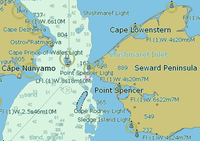
 The chart uses symbols to provide pilotage
information about the nature and position of features useful to navigators, such as sea bed information, sea mark
s and landmarks. Some symbols describe the sea bed with information such as its depth, materials as well as possible hazards such as shipwreck
s. Other symbols show the position and characteristics of buoy
s, lights
, lighthouse
s, coastal and land features and structures that are useful for position fixing
.
Colours distinguish between man-made features, dry land, sea bed that dries with the tide and seabed that is permanently underwater
and indicate water depth.
 Depths which have been measured are indicated by the numbers shown on the chart. Depths on charts published in most parts of the world use metres. Older charts, as well as those published by the United States
government, may use feet or fathom
s. Depth contour line
s show the shape of underwater relief
. Coloured areas of the sea emphasise shallow water and dangerous underwater obstructions. Depths are measured from the chart datum
, which is related to the local sea level. The chart datum varies according to the standard used by each National Hydrographic Office.In general, the move is towards using Lowest Astronomical Tide (LAT), the lowest tide predicted in the full tidal cycle, but in non-tidal areas and some tidal areas Mean Sea Level (MSL) is used.
Heights eg a lighthouse, are generally given relative to Mean High Water Springs,(MHWS). Vertical clearances eg below a bridge or cable are given relative to Highest Astronomical Tide (HAT). The chart will indicate what datum is in use.
The use of HAT for heights, and LAT for depths, means that the mariner can quickly look at the chart to ensure that they have sufficient clearance to pass any obstruction, though they may have to calculate height of tide to ensure their safety.
s and other strong currents have special chart symbols. Tidal flow information may be shown on charts using tidal diamond
s, indicating the speed and bearing of the tidal flow during each hour of the tidal cycle.
Sea
A sea generally refers to a large body of salt water, but the term is used in other contexts as well. Most commonly, it means a large expanse of saline water connected with an ocean, and is commonly used as a synonym for ocean...
area and adjacent coast
Coast
A coastline or seashore is the area where land meets the sea or ocean. A precise line that can be called a coastline cannot be determined due to the dynamic nature of tides. The term "coastal zone" can be used instead, which is a spatial zone where interaction of the sea and land processes occurs...
al regions. Depending on the scale
Scale (map)
The scale of a map is defined as the ratio of a distance on the map to the corresponding distance on the ground.If the region of the map is small enough for the curvature of the Earth to be neglected, then the scale may be taken as a constant ratio over the whole map....
of the chart, it may show depths of water
Water
Water is a chemical substance with the chemical formula H2O. A water molecule contains one oxygen and two hydrogen atoms connected by covalent bonds. Water is a liquid at ambient conditions, but it often co-exists on Earth with its solid state, ice, and gaseous state . Water also exists in a...
and heights of land (topographic map
Topographic map
A topographic map is a type of map characterized by large-scale detail and quantitative representation of relief, usually using contour lines in modern mapping, but historically using a variety of methods. Traditional definitions require a topographic map to show both natural and man-made features...
), natural features of the seabed, details of the coastline, navigational hazards, locations of natural and man-made aids to navigation
Navigation
Navigation is the process of monitoring and controlling the movement of a craft or vehicle from one place to another. It is also the term of art used for the specialized knowledge used by navigators to perform navigation tasks...
, information on tide
Tide
Tides are the rise and fall of sea levels caused by the combined effects of the gravitational forces exerted by the moon and the sun and the rotation of the Earth....
s and current
Ocean current
An ocean current is a continuous, directed movement of ocean water generated by the forces acting upon this mean flow, such as breaking waves, wind, Coriolis effect, cabbeling, temperature and salinity differences and tides caused by the gravitational pull of the Moon and the Sun...
s, local details of the Earth's magnetic field
Earth's magnetic field
Earth's magnetic field is the magnetic field that extends from the Earth's inner core to where it meets the solar wind, a stream of energetic particles emanating from the Sun...
, and man-made structures such as harbours, buildings, and bridge
Bridge
A bridge is a structure built to span physical obstacles such as a body of water, valley, or road, for the purpose of providing passage over the obstacle...
s. Nautical charts are essential tools for marine navigation; many countries require vessels, especially commercial ships, to carry them. Nautical charting may take the form of charts printed on paper or computerised electronic navigational chart
Electronic navigational chart
An electronic navigational chart is an official database created by a national hydrographic office for use with an Electronic Chart Display and Information System . An electronic chart must conform to standards stated in the International Hydrographic Organization Special Publication S-57 before...
s. Recent technologies have made available paper charts which are printed "on demand" with cartographic data that has been downloaded to the commercial printing company as recently as the night before printing. With each daily download, critical data such as Local Notice to Mariners is added to the on-demand chart files so that these charts will be 100% up to date at the time of printing.
Sources and publication of nautical charts
Nautical charts are based on hydrographic surveyHydrographic survey
Hydrographic survey is the science of measurement and description of features which affect maritime navigation, marine construction, dredging, offshore oil exploration/drilling and related disciplines. Strong emphasis is placed on soundings, shorelines, tides, currents, sea floor and submerged...
s. As surveying is laborious and time-consuming, hydrographic data for many areas of sea may be dated and not always reliable. Depths are measured in a variety of ways. Historically the sounding line
Sounding line
A sounding line or lead line is a length of thin rope with a plummet, generally of lead, at its end. Regardless of the actual composition of the plummet, it is still called a "lead."...
was used. In modern times, echo sounding
Echo sounding
Echo sounding is the technique of using sound pulses directed from the surface or from a submarine vertically down to measure the distance to the bottom by means of sound waves. This information is then typically used for navigation purposes or in order to obtain depths for charting purposes...
is used for measuring the seabed in the open sea. When measuring the safe depth of water over an entire obstruction, such as a shipwreck
Shipwreck
A shipwreck is what remains of a ship that has wrecked, either sunk or beached. Whatever the cause, a sunken ship or a wrecked ship is a physical example of the event: this explains why the two concepts are often overlapping in English....
, the minimum depth is checked by sweeping the area with a length of horizontal wire
Wire
A wire is a single, usually cylindrical, flexible strand or rod of metal. Wires are used to bear mechanical loads and to carry electricity and telecommunications signals. Wire is commonly formed by drawing the metal through a hole in a die or draw plate. Standard sizes are determined by various...
. This ensures that difficult to find projections, such as masts
Mast (sailing)
The mast of a sailing vessel is a tall, vertical, or near vertical, spar, or arrangement of spars, which supports the sails. Large ships have several masts, with the size and configuration depending on the style of ship...
, do not present a danger to vessels navigating over the obstruction.
Nautical charts are issued by the national hydrographic office
Hydrographic office
A hydrographic office is an organization which is devoted to acquiring and publishing hydrographic information.Historically, the main tasks of hydrographic offices were the conduction of hydrographic surveys and the publication of nautical charts...
s in many countries. These charts are considered "official" in contrast to those made by commercial publishers. Many hydrographic offices provide regular, sometimes weekly, manual updates of their charts through their sales agents. Individual hydrographic office
Hydrographic office
A hydrographic office is an organization which is devoted to acquiring and publishing hydrographic information.Historically, the main tasks of hydrographic offices were the conduction of hydrographic surveys and the publication of nautical charts...
s produce national chart series and international chart series. Coordinated by the International Hydrographic Organization
International Hydrographic Organization
The International Hydrographic Organization is the inter-governmental organisation representing the hydrographic community. It enjoys observer status at the UN and is the recognised competent authority on hydrographic surveying and nautical charting...
, the international chart series is a worldwide system of charts ("INT" chart series), which is being developed with the goal of unifying as many chart systems as possible.
There are also commercially published charts, some of which may carry additional information of particular interest, e.g. for yacht skippers.
Free nautical charts
An ocean mapping site with free charts, and a social network for sea lovers is a worldwide ocean mapping site, a mobile app, and a social networkSocial network
A social network is a social structure made up of individuals called "nodes", which are tied by one or more specific types of interdependency, such as friendship, kinship, common interest, financial exchange, dislike, sexual relationships, or relationships of beliefs, knowledge or prestige.Social...
for sea lovers, offering free NOAA/United States
United States
The United States of America is a federal constitutional republic comprising fifty states and a federal district...
, New Zealand
New Zealand
New Zealand is an island country in the south-western Pacific Ocean comprising two main landmasses and numerous smaller islands. The country is situated some east of Australia across the Tasman Sea, and roughly south of the Pacific island nations of New Caledonia, Fiji, and Tonga...
/Pacific Ocean
Pacific Ocean
The Pacific Ocean is the largest of the Earth's oceanic divisions. It extends from the Arctic in the north to the Southern Ocean in the south, bounded by Asia and Australia in the west, and the Americas in the east.At 165.2 million square kilometres in area, this largest division of the World...
and Brazil
Brazil
Brazil , officially the Federative Republic of Brazil , is the largest country in South America. It is the world's fifth largest country, both by geographical area and by population with over 192 million people...
charts. BlooSee
Bloosee
BlooSee is a social network and an ocean web mapping site where sailors, divers, surfers and other sea lovers geotag and share information and knowledge about the oceans. BlooSee is built in Python and uses the Google Maps API.BlooSee is owned by BlooSee, Inc...
leverages the power of the community to complement official nautical chart data with content generated by sailors, surfers, divers, kayakers, fisherman, NGO's, merchants, and other ocean communities. BlooSee
Bloosee
BlooSee is a social network and an ocean web mapping site where sailors, divers, surfers and other sea lovers geotag and share information and knowledge about the oceans. BlooSee is built in Python and uses the Google Maps API.BlooSee is owned by BlooSee, Inc...
's charts and data are layered over the satellite imagery of Google Maps
Google Maps
Google Maps is a web mapping service application and technology provided by Google, free , that powers many map-based services, including the Google Maps website, Google Ride Finder, Google Transit, and maps embedded on third-party websites via the Google Maps API...
/Google Earth
Google Earth
Google Earth is a virtual globe, map and geographical information program that was originally called EarthViewer 3D, and was created by Keyhole, Inc, a Central Intelligence Agency funded company acquired by Google in 2004 . It maps the Earth by the superimposition of images obtained from satellite...
.
Marine GeoGarage is the first nautical chart web portal in the Cloud. The website allows to freely view seamless georeferenced nautical raster chart layers issued from different Hydrographic Services (NOAA US, Linz NZ , DNH Brazil) upon Google Maps imagery.
Additional free features are available for the user (voyage planning, waypoint and route monitoring with transfer to GPS, bearing and distance calculations).
OpenSeaMap.org
OpenSeaMap
OpenSeaMap is a software project collecting freely usable nautical information and geospatial data to create a worldwide nautical chart. This chart is available on the OpenSeaMap website, and can also be downloaded for use as an electronic chart for offline applications.The project is part of...
(OSeaM) is a free nautical chart. It's a worldwide Wiki-project and part of OpenStreetMap
OpenStreetMap
OpenStreetMap is a collaborative project to create a free editable map of the world. Two major driving forces behind the establishment and growth of OSM have been restrictions on use or availability of map information across much of the world and the advent of inexpensive portable GPS devices.The...
. Everybody can contribute his nautical knowledges about estuary
Sea
A sea generally refers to a large body of salt water, but the term is used in other contexts as well. Most commonly, it means a large expanse of saline water connected with an ocean, and is commonly used as a synonym for ocean...
, harbours and Marina
Marina
A marina is a dock or basin with moorings and supplies for yachts and small boats.A marina differs from a port in that a marina does not handle large passenger ships or cargo from freighters....
, as geografic chart informations and as textdata in a linked Wiki-port pilot book. OpenSeaMap covers worldwide all seas and the inland waterways. The chart shows lights
Lighthouse
A lighthouse is a tower, building, or other type of structure designed to emit light from a system of lamps and lenses or, in older times, from a fire, and used as an aid to navigation for maritime pilots at sea or on inland waterways....
, buoy
Buoy
A buoy is a floating device that can have many different purposes. It can be anchored or allowed to drift. The word, of Old French or Middle Dutch origin, is now most commonly in UK English, although some orthoepists have traditionally prescribed the pronunciation...
s, harbour informations and a lot of other nautical geo-data. The chart displays also weather
Weather
Weather is the state of the atmosphere, to the degree that it is hot or cold, wet or dry, calm or stormy, clear or cloudy. Most weather phenomena occur in the troposphere, just below the stratosphere. Weather refers, generally, to day-to-day temperature and precipitation activity, whereas climate...
informations like wind, air pressure, wave hight on a detailed worldwide weather chart including a weather forecast
Weather forecasting
Weather forecasting is the application of science and technology to predict the state of the atmosphere for a given location. Human beings have attempted to predict the weather informally for millennia, and formally since the nineteenth century...
for three days.
TeamSurv creates charts using crowd sourced data. Boats log GPS and depth sounder information (plus compass heading and sea surface temperature when available) as they go about their nortmal activities, and upload the data to the server where the data undergoes quality checks and is corrected for tide height, speed of sound and other factors before being used to create a chart. Data can be collected using a hardware logger or through a number of software packages, and is open to all. Processed data can be viewed at the teamsurv.eu web site, overlaid on top of Google Maps
Google Maps
Google Maps is a web mapping service application and technology provided by Google, free , that powers many map-based services, including the Google Maps website, Google Ride Finder, Google Transit, and maps embedded on third-party websites via the Google Maps API...
.
National Oceanic and Atmospheric Administration
The National Oceanic and Atmospheric Administration , pronounced , like "noah", is a scientific agency within the United States Department of Commerce focused on the conditions of the oceans and the atmosphere...
is now offering complete detailed nautical charts for free download for home printing for the entire US coast. The charts are continuously updated. This should improve the safety at sea, while reducing costs for mariners. Note, however, that these print-at-home charts will typically not offer the detail that "full size" NOAA charts do.
The UK Hydrographic Office (UKHO)is widely recognised as the leading authority and publishes the series of British Admiralty charts and supplies 70% of the chart market, electronic and paper.
Chart correction
The nature of a waterway depicted by a chart may change, and artificial aids to navigation may be altered at short notice. Therefore, old or uncorrected charts should never be used for navigation. Every producer of nautical charts also provides a system to inform mariners of changes that affect the chart. In the United States, chart corrections and notifications of new editions are provided by various governmental agencies by way of Notice to MarinersNotice to Mariners
A notice to mariners advises mariners of important matters affecting navigational safety, including new hydrographic information, changes in channels and aids to navigation, and other important data.Over 60 countries which produce nautical charts also...
, Local Notice to Mariners
Local Notice to Mariners
A Local Notice to Mariners is an authoritative instruction issued by a designated official, typically the harbormaster.-United States:In the United States, notices are issued by each U.S. Coast Guard District to disseminate important information affecting navigational safety within that District...
, Summary of Corrections, and Broadcast Notice to Mariners. In the U.S., NOAA also has a printing partner who prints the "POD" (print on demand) NOAA charts, and they contain the very latest corrections and notifications at the time of printing. Radio broadcasts give advance notice of urgent corrections.
A good way to keep track of corrections is with a Chart and Publication Correction Record Card system. Using this system, the navigator does not immediately update every chart in the portfolio when a new Notice to Mariners arrives, instead creating a card for every chart and noting the correction on this card. When the time comes to use the chart, he pulls the chart and chart's card, and makes the indicated corrections on the chart. This system ensures that every chart is properly corrected prior to use. A prudent mariner should obtain a new chart if he or she has not kept track of corrections and his chart is more than several months old.
Various Digital Notices to Mariners systems are available on the market such as Digitrace (http://www.marinepress.com/mpc/index.html), Voyager (www.tgnsvoyager.com), ChartCo (www.http://www.chartco.com/) to correct British Admiralty charts as well as NOAA charts. These systems provides only vessels relevant corrections via e-mail or web downloads reducing time needed to sort our correction for each chart. Also, tracings to assist corrections are provided at the same time.
The Canadian Coast Guard also produces the Notice to Mariners publication which informs mariners of important navigational safety matters affecting Canadian Waters. This electronic publication is published on a monthly basis and can be downloaded from the Notices to Mariners (NOTMAR) Web site. The information in the Notice to Mariners is formatted to simplify the correction of paper charts and navigational publications.
Various and diverse methods exist for the correction of electronic navigational charts.
Limitations
In 1973 the cargo ship MV Muirfield (a merchant vessel named after Muirfield, ScotlandScotland
Scotland is a country that is part of the United Kingdom. Occupying the northern third of the island of Great Britain, it shares a border with England to the south and is bounded by the North Sea to the east, the Atlantic Ocean to the north and west, and the North Channel and Irish Sea to the...
) struck an unknown object in waters charted at a depth of greater than 5,000 metres (16,404 ft), resulting in extensive damage to her keel
Keel
In boats and ships, keel can refer to either of two parts: a structural element, or a hydrodynamic element. These parts overlap. As the laying down of the keel is the initial step in construction of a ship, in British and American shipbuilding traditions the construction is dated from this event...
. In 1983, HMAS Moresby
HMAS Moresby (1963)
HMAS Moresby, named for the explorer Captain John Moresby, was a hydrographic survey ship of the Royal Australian Navy . Serving in the RAN from 1964 to 1999, Moresby was then sold into civilian service...
, a Royal Australian Navy
Royal Australian Navy
The Royal Australian Navy is the naval branch of the Australian Defence Force. Following the Federation of Australia in 1901, the ships and resources of the separate colonial navies were integrated into a national force: the Commonwealth Naval Forces...
survey ship, surveyed the area where Muirfield was damaged, and charted in detail this previously unsuspected hazard to navigation
Navigation
Navigation is the process of monitoring and controlling the movement of a craft or vehicle from one place to another. It is also the term of art used for the specialized knowledge used by navigators to perform navigation tasks...
, the Muirfield Seamount
Muirfield Seamount
The Muirfield Seamount is a submarine mountain located in the Indian Ocean approximately 130 kilometres southwest of the Cocos Islands. The Cocos Islands are an Australian territory, and therefore the Muirfield Seamount is within in Australia's Exclusive Economic Zone...
.
The dramatic accidental discovery of the Muirfield Seamount is often cited as an example of limitations in the vertical datum accuracy of some offshore areas as represented on nautical charts, especially on small-scale
Level of measurement
The "levels of measurement", or scales of measure are expressions that typically refer to the theory of scale types developed by the psychologist Stanley Smith Stevens. Stevens proposed his theory in a 1946 Science article titled "On the theory of scales of measurement"...
charts. A similar incident involving a passenger ship occurred in 1992 when the Cunard
Cunard Line
Cunard Line is a British-American owned shipping company based at Carnival House in Southampton, England and operated by Carnival UK. It has been a leading operator of passenger ships on the North Atlantic for over a century...
liner RMS Queen Elizabeth 2
RMS Queen Elizabeth 2
Queen Elizabeth 2, often referred to simply as the QE2, is an ocean liner that was operated by Cunard from 1969 to 2008. Following her retirement from cruising, she is now owned by Istithmar...
struck a submerged rock off Block Island
Block Island
Block Island is part of the U.S. state of Rhode Island and is located in the Atlantic Ocean approximately south of the coast of Rhode Island, east of Montauk Point on Long Island, and is separated from the Rhode Island mainland by Block Island Sound. The United States Census Bureau defines Block...
in the Atlantic Ocean
Atlantic Ocean
The Atlantic Ocean is the second-largest of the world's oceanic divisions. With a total area of about , it covers approximately 20% of the Earth's surface and about 26% of its water surface area...
. More recently, in 2005 the submarine USS San Francisco (SSN-711)
USS San Francisco (SSN-711)
USS San Francisco , a Los Angeles-class nuclear submarine, is the third ship or boat of the United States Navy to be named for San Francisco, California.-History:...
ran into an uncharted seamount about 560 kilometers (350 statute miles) south of Guam at a speed of 35 kn (42.6 mph; 68.6 km/h), sustaining serious damage and killing one seaman.
Map projection, positions, and bearings
Mercator projection
The Mercator projection is a cylindrical map projection presented by the Belgian geographer and cartographer Gerardus Mercator, in 1569. It became the standard map projection for nautical purposes because of its ability to represent lines of constant course, known as rhumb lines or loxodromes, as...
is almost universally used in nautical charts. There are however some exceptions for very large or small scales
Level of measurement
The "levels of measurement", or scales of measure are expressions that typically refer to the theory of scale types developed by the psychologist Stanley Smith Stevens. Stevens proposed his theory in a 1946 Science article titled "On the theory of scales of measurement"...
where projections such as the gnomonic projection
Gnomonic projection
A gnomonic map projection displays all great circles as straight lines. Thus the shortest route between two locations in reality corresponds to that on the map. This is achieved by projecting, with respect to the center of the Earth , the Earth's surface onto a tangent plane. The least distortion...
may be used. Since the Mercator projection is conformal
Conformal map
In mathematics, a conformal map is a function which preserves angles. In the most common case the function is between domains in the complex plane.More formally, a map,...
, that is, bearings in the chart are identical to the corresponding angles in nature, bearings may be measured from the chart to be used at sea or plotted on the chart from measurements taken at sea.
Positions of places shown on the chart can be measured from the longitude
Longitude
Longitude is a geographic coordinate that specifies the east-west position of a point on the Earth's surface. It is an angular measurement, usually expressed in degrees, minutes and seconds, and denoted by the Greek letter lambda ....
and latitude
Latitude
In geography, the latitude of a location on the Earth is the angular distance of that location south or north of the Equator. The latitude is an angle, and is usually measured in degrees . The equator has a latitude of 0°, the North pole has a latitude of 90° north , and the South pole has a...
scales on the borders of the chart, relative to a map datum such as WGS 84.
A bearing
Bearing (navigation)
In marine navigation, a bearing is the direction one object is from another object, usually, the direction of an object from one's own vessel. In aircraft navigation, a bearing is the actual compass direction of the forward course of the aircraft...
is the angle between the line joining the two points of interest and the line from one of the points to the north
North
North is a noun, adjective, or adverb indicating direction or geography.North is one of the four cardinal directions or compass points. It is the opposite of south and is perpendicular to east and west.By convention, the top side of a map is north....
, such as a ship’s course
Course (navigation)
In navigation, a vehicle's course is the angle that the intended path of the vehicle makes with a fixed reference object . Typically course is measured in degrees from 0° clockwise to 360° in compass convention . Course is customarily expressed in three digits, using preliminary zeros if needed,...
or a compass reading to a landmark. On nautical charts, the top of the chart is always true north
True north
True north is the direction along the earth's surface towards the geographic North Pole.True geodetic north usually differs from magnetic north , and from grid north...
, rather than magnetic north, towards which a magnetic compass points. Most charts include a compass rose
Compass rose
A compass rose, sometimes called a windrose, is a figure on a compass, map, nautical chart or monument used to display the orientation of the cardinal directions — North, East, South and West - and their intermediate points. It is also the term for the graduated markings found on the traditional...
depicting the variation
Magnetic declination
Magnetic declination is the angle between magnetic north and true north. The declination is positive when the magnetic north is east of true north. The term magnetic variation is a synonym, and is more often used in navigation...
between magnetic and true north.
Electronic and paper charts
Scale (map)
The scale of a map is defined as the ratio of a distance on the map to the corresponding distance on the ground.If the region of the map is small enough for the curvature of the Earth to be neglected, then the scale may be taken as a constant ratio over the whole map....
s. Mariners will generally carry many charts to provide sufficient detail for the areas they might need to visit. Electronic navigational chart
Electronic navigational chart
An electronic navigational chart is an official database created by a national hydrographic office for use with an Electronic Chart Display and Information System . An electronic chart must conform to standards stated in the International Hydrographic Organization Special Publication S-57 before...
s, which use computer software and electronic databases to provide navigation information, can augment or in some cases replace paper charts, though many mariners carry paper charts as a backup in case the electronic charting system fails.
Labeling nautical charts
Automatic label placement
Automatic label placement refers to the computer methods of placing labels automatically on a map or chart. This is related to the typographic design of such labels....
.
Pilotage information
Pilotage
Pilotage is the use of fixed visual references on the ground or sea by means of sight or radar to guide oneself to a destination, sometimes with the help of a map or nautical chart. People use pilotage for activities such as guiding vessels and aircraft, hiking and Scuba diving...
information about the nature and position of features useful to navigators, such as sea bed information, sea mark
Sea mark
A sea mark, also seamark and navigation mark, is a form of aid to navigation and pilotage aid which identifies the approximate position of a maritime channel, hazard and administrative area to allow boats, ships and seaplanes to navigate safely....
s and landmarks. Some symbols describe the sea bed with information such as its depth, materials as well as possible hazards such as shipwreck
Shipwreck
A shipwreck is what remains of a ship that has wrecked, either sunk or beached. Whatever the cause, a sunken ship or a wrecked ship is a physical example of the event: this explains why the two concepts are often overlapping in English....
s. Other symbols show the position and characteristics of buoy
Buoy
A buoy is a floating device that can have many different purposes. It can be anchored or allowed to drift. The word, of Old French or Middle Dutch origin, is now most commonly in UK English, although some orthoepists have traditionally prescribed the pronunciation...
s, lights
Characteristic light
A light characteristic is a graphic and text description of a navigational light sequence or colour displayed on a nautical chart or in a Light List with the chart symbol for a lighthouse, lightvessel, buoy or sea mark with a light on it. The graphic indicates how the real light beacon may be...
, lighthouse
Lighthouse
A lighthouse is a tower, building, or other type of structure designed to emit light from a system of lamps and lenses or, in older times, from a fire, and used as an aid to navigation for maritime pilots at sea or on inland waterways....
s, coastal and land features and structures that are useful for position fixing
Position fixing
Position fixing is the branch of navigation concerned with the use of a variety of visual and electronic methods to determine the position of a ship, aircraft or person on the surface of the Earth.These techniques include:...
.
Colours distinguish between man-made features, dry land, sea bed that dries with the tide and seabed that is permanently underwater
Underwater
Underwater is a term describing the realm below the surface of water where the water exists in a natural feature such as an ocean, sea, lake, pond, or river. Three quarters of the planet Earth is covered by water...
and indicate water depth.
Depths and Heights
United States
The United States of America is a federal constitutional republic comprising fifty states and a federal district...
government, may use feet or fathom
Fathom
A fathom is a unit of length in the imperial and the U.S. customary systems, used especially for measuring the depth of water.There are 2 yards in an imperial or U.S. fathom...
s. Depth contour line
Contour line
A contour line of a function of two variables is a curve along which the function has a constant value. In cartography, a contour line joins points of equal elevation above a given level, such as mean sea level...
s show the shape of underwater relief
Relief
Relief is a sculptural technique. The term relief is from the Latin verb levo, to raise. To create a sculpture in relief is thus to give the impression that the sculpted material has been raised above the background plane...
. Coloured areas of the sea emphasise shallow water and dangerous underwater obstructions. Depths are measured from the chart datum
Chart datum
A chart datum is the level of water that charted depths displayed on a nautical chart are measured from. A chart datum is generally a tidal datum; that is, a datum derived from some phase of the tide...
, which is related to the local sea level. The chart datum varies according to the standard used by each National Hydrographic Office.In general, the move is towards using Lowest Astronomical Tide (LAT), the lowest tide predicted in the full tidal cycle, but in non-tidal areas and some tidal areas Mean Sea Level (MSL) is used.
Heights eg a lighthouse, are generally given relative to Mean High Water Springs,(MHWS). Vertical clearances eg below a bridge or cable are given relative to Highest Astronomical Tide (HAT). The chart will indicate what datum is in use.
The use of HAT for heights, and LAT for depths, means that the mariner can quickly look at the chart to ensure that they have sufficient clearance to pass any obstruction, though they may have to calculate height of tide to ensure their safety.
Tidal information
Tidal raceTidal race
Tidal race is a natural occurrence whereby a fast moving tide passes through a constriction resulting in the formation of waves, eddies and hazardous currents...
s and other strong currents have special chart symbols. Tidal flow information may be shown on charts using tidal diamond
Tidal diamond
Tidal diamonds are symbols on British admiralty charts that indicate the direction and speed of tidal streams.The symbols consist of a letter of the Roman alphabet in a rhombus, printed in purple ink...
s, indicating the speed and bearing of the tidal flow during each hour of the tidal cycle.
See also
- Aeronautical chartAeronautical chartAn aeronautical chart is a map designed to assist in navigation of aircraft, much as nautical charts do for watercraft, or a roadmap for drivers...
- Automatic label placementAutomatic label placementAutomatic label placement refers to the computer methods of placing labels automatically on a map or chart. This is related to the typographic design of such labels....
- Admiralty chartAdmiralty chartAdmiralty charts are nautical charts issued by the United Kingdom Hydrographic Office and subject to Crown Copyright. Over 3,000 charts are available and cover virtually the entire world in various levels of detail depending on the density of traffic and hazards...
- European Atlas of the SeasEuropean Atlas of the SeasThe European Atlas of the Seas is an interactive electronic atlas on the coasts and seas within and around Europe. The atlas is freely accessible on the internet and is available in English, French and German...
External links
- Online version of Chart No.1 with "Symbols, Abbreviations and Terms" used in nautical charts
- Nautical Charts - chapter from the online edition of Nathaniel BowditchNathaniel BowditchNathaniel Bowditch was an early American mathematician remembered for his work on ocean navigation. He is often credited as the founder of modern maritime navigation; his book The New American Practical Navigator, first published in 1802, is still carried on board every commissioned U.S...
's American Practical Navigator - http://www.qhmportsmouth.com/images/charts/large/eastern-solent.pngNautical chart of the Eastern Approaches to the SolentSolentThe Solent is a strait separating the Isle of Wight from the mainland of England.The Solent is a major shipping route for passengers, freight and military vessels. It is an important recreational area for water sports, particularly yachting, hosting the Cowes Week sailing event annually...
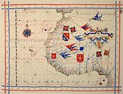
] - Portolan Chart of Gabriel de Vallseca, 1439
- Guides to Nautical Chart Symbols
- Nautical chart of New York Harbor
- Nautical chart symbols for aids to navigation