

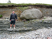
Raised beach
Encyclopedia
Emergent coastline
Emergent coastlines are stretches along the coast that have been exposed by the sea due to a relative fall in sea levels. This occurs due to either isostacy or eustacy....
landform
Landform
A landform or physical feature in the earth sciences and geology sub-fields, comprises a geomorphological unit, and is largely defined by its surface form and location in the landscape, as part of the terrain, and as such, is typically an element of topography...
. Raised beaches and marine terraces are beach
Beach
A beach is a geological landform along the shoreline of an ocean, sea, lake or river. It usually consists of loose particles which are often composed of rock, such as sand, gravel, shingle, pebbles or cobblestones...
es or wave-cut platform
Wave-cut platform
A wave-cut platform, or shore platform is the narrow flat area often found at the base of a sea cliff or along the shoreline of a lake, bay, or sea that was created by the action of waves. Wave-cut platforms are often most obvious at low tide when they become visible as huge areas of flat rock...
s raised above the shore line by a relative fall in the sea
Sea
A sea generally refers to a large body of salt water, but the term is used in other contexts as well. Most commonly, it means a large expanse of saline water connected with an ocean, and is commonly used as a synonym for ocean...
level .
Around the world, a combination of tectonic coastal uplift and Quaternary sea-level fluctuations has resulted in the formation of marine terrace sequences, most of which were formed during separate interglacial highstands that can be correlated to Marine Oxygen Isotopic Stages (MIS) (for example, Johnson and Libbey (1997).
A marine terrace commonly retains a shoreline angle or inner edge, the slope inflection between the marine abrasion platform and the associated paleo sea-cliff. The shoreline angle represents the maximum shoreline of a transgression and therefore a paleo sea level.
Origin
It is now widely thought that marine terraces are formed during the separated highstands of interglacial stages correlated to Marine Oxygen Isotopic Stages (MIS) (James et al., 1971; Chappell, 1974; Bull, 1985; Ota, 1986; Muhs et al., 1990).Tectonical and or eustatical use of marine terrace sequence
The total displacement of the shoreline relative to the age of the associated interglacial stage allows calculation of a mean uplift rate or the calculation of eustatical level at a particular time if the uplift is known.In order to estimate vertical uplift, the eustatic position of the considered paleo sea levels relative to the present one must be known as precisely as possible. Our chronology relies principally on relative dating based on geomorphologic criteria but in all cases we associated the shoreline angle of the marine terraces with numerical ages. The best-represented terrace worldwide is the one correlated to the last interglacial maximum (MISS 5e) (Hearty and Kindler, 1995; Johnson and Libbey, 1997, Pedoja et al., 2006 a, b, c). Age of MISS 5e is arbitrarily fixed to range from 130 to 116 ka (Kukla et al., 2002) but is demonstrated to range from 134 to 113 ka in Hawaii and Barbados (Muhs et al., 2002) with a peak from 128 to 116 ka on tectonically stable coastlines (Muhs, 2002). Older marine terraces well represented in worldwide sequences are those related to MIS 9 (~303-339 ka) and 11 (~362-423 ka) (Imbrie et al., 1984). Compilations show that sea level was 3 ± 3 meters higher during MISS 5e, MIS 9 and 11 than during the present one and –1 ± 1 m to the present one during MIS 7 (Hearty and Kindler, 1995, Zazo, 1999). Consequently MIS 7 (~180-240 ka; Imbrie et al., 1984) marine terraces are less pronounced and sometimes absent (Zazo, 1999). When the elevations of these terraces are higher than the uncertainties in paleo-eustatic sea level mentioned for the Holocene and Late Pleistocene, these uncertainties have no effect on overall interpretation.
Sequence can also occurs where the accumulation of ice sheets have depressed the land so that when the ice sheets melts the land readjusts with time thus raising the height of the beaches (glacio-isostatic rebound)and in places where co-seismic uplift occur. In the latter case, the terrace are not correlated with sea level highstand even if co-seismic terrace are known only for the Holocene.
Other coastal Quaternary morphologies registering uplift
Uplift can also be registered through tidal notch sequences. Notches are often portrayed as lying at sea level; however notch types actually form a continuum from wave notches formed in quiet conditions at sea level to surf notches formed in more turbulent conditions and as much as 2 m (6.6 ft) above sea level (Pirazzoli et al., 1996 in Rust and Kershaw, 2000). As stated above, there was at least one higher sea level during the Holocene, so that some notches may not contain a tectonic component in their formation.World wide occurrence
Raised beaches are found in a wide variety of coast and geodynamical background such as subduction on the pacific coast of South America (Pedoja et al., 2006), of North America, passive margin of the Atlantic coast of South America (Rostami et al., 2000), collision context on the Pacific coast of Kamchatka (Pedoja et al., 2006), Papua New Guinea, New Zealand, Japan (Ota and Yamaguchi, 2004), passive margin of the South China sea coast (Pedoja et al., in press), on west-facing Atlantic coasts, such as Donegal BayDonegal Bay
Donegal Bay is an inlet in the northwest of Ireland. Three counties – Donegal to the north and west, Leitrim and Sligo to the south – have shorelines on the bay, which is bounded on the west by the Atlantic Ocean...
, County Cork
County Cork
County Cork is a county in Ireland. It is located in the South-West Region and is also part of the province of Munster. It is named after the city of Cork . Cork County Council is the local authority for the county...
and County Kerry
County Kerry
Kerry means the "people of Ciar" which was the name of the pre-Gaelic tribe who lived in part of the present county. The legendary founder of the tribe was Ciar, son of Fergus mac Róich. In Old Irish "Ciar" meant black or dark brown, and the word continues in use in modern Irish as an adjective...
in Ireland
Ireland
Ireland is an island to the northwest of continental Europe. It is the third-largest island in Europe and the twentieth-largest island on Earth...
; Bude
Bude
Bude is a small seaside resort town in North Cornwall, England, at the mouth of the River Neet . It lies just south of Flexbury, north of Widemouth Bay and west of Stratton and is located along the A3073 road off the A39. Bude is twinned with Ergué-Gabéric in Brittany, France...
, Widemouth Bay
Widemouth Bay
Widemouth Bay is a bay and beach on the Atlantic coast of Cornwall, England, UK, approximately 3 miles south of Bude. This stretch of coast is steeped in the smuggling history of times before, and not far south of Widemouth Bay can be found many little inlets and coves.-Activities:The beach is...
, Crackington Haven
Crackington Haven
Crackington Haven is a coastal village in Cornwall, United Kingdom. It is located in the civil parish of St Gennys at at the head of a cove on the Atlantic coast. The village is seven miles south-southwest of Bude and four miles north-northeast of Boscastle.Middle Crackington and Higher...
, Tintagel
Tintagel
Tintagel is a civil parish and village situated on the Atlantic coast of Cornwall, United Kingdom. The population of the parish is 1,820 people, and the area of the parish is ....
, Perranporth
Perranporth
Perranporth is a small seaside resort on the north coast of Cornwall, England, United Kingdom. It is southwest of Newquay and northwest of Truro. Perranporth and its long beach face the Atlantic Ocean....
and St Ives
St Ives, Cornwall
St Ives is a seaside town, civil parish and port in Cornwall, England, United Kingdom. The town lies north of Penzance and west of Camborne on the coast of the Celtic Sea. In former times it was commercially dependent on fishing. The decline in fishing, however, caused a shift in commercial...
in Cornwall
Cornwall
Cornwall is a unitary authority and ceremonial county of England, within the United Kingdom. It is bordered to the north and west by the Celtic Sea, to the south by the English Channel, and to the east by the county of Devon, over the River Tamar. Cornwall has a population of , and covers an area of...
, the Vale of Glamorgan
Vale of Glamorgan
The Vale of Glamorgan is a county borough in Wales; an exceptionally rich agricultural area, it lies in the southern part of Glamorgan, South Wales...
, Gower Peninsula
Gower Peninsula
Gower or the Gower Peninsula is a peninsula in south Wales, jutting from the coast into the Bristol Channel, and administratively part of the City and County of Swansea. Locally it is known as "Gower"...
, Pembrokeshire
Pembrokeshire
Pembrokeshire is a county in the south west of Wales. It borders Carmarthenshire to the east and Ceredigion to the north east. The county town is Haverfordwest where Pembrokeshire County Council is headquartered....
and Cardigan Bay
Cardigan Bay
Cardigan Bay is a large inlet of the Irish Sea, indenting the west coast of Wales between Bardsey Island, Gwynedd in the north, and Strumble Head, Pembrokeshire at its southern end. It is the largest bay in Wales....
in Wales
Wales
Wales is a country that is part of the United Kingdom and the island of Great Britain, bordered by England to its east and the Atlantic Ocean and Irish Sea to its west. It has a population of three million, and a total area of 20,779 km²...
, the Isle of Jura and Isle of Arran
Isle of Arran
Arran or the Isle of Arran is the largest island in the Firth of Clyde, Scotland, and with an area of is the seventh largest Scottish island. It is in the unitary council area of North Ayrshire and the 2001 census had a resident population of 5,058...
in Scotland
Scotland
Scotland is a country that is part of the United Kingdom. Occupying the northern third of the island of Great Britain, it shares a border with England to the south and is bounded by the North Sea to the east, the Atlantic Ocean to the north and west, and the North Channel and Irish Sea to the...
, Finistère
Finistère
Finistère is a département of France, in the extreme west of Brittany.-History:The name Finistère derives from the Latin Finis Terræ, meaning end of the earth, and may be compared with Land's End on the opposite side of the English Channel...
in Brittany
Brittany
Brittany is a cultural and administrative region in the north-west of France. Previously a kingdom and then a duchy, Brittany was united to the Kingdom of France in 1532 as a province. Brittany has also been referred to as Less, Lesser or Little Britain...
and Galicia in Northern Spain and at Squally Point in the Cape Chignecto Provincial Park
Cape Chignecto Provincial Park
Cape Chignecto Provincial Park is a Canadian provincial park located in Nova Scotia. A wilderness park, it derives its name from Cape Chignecto, a prominent headland which divides the Bay of Fundy with Chignecto Bay to the north and the Minas Channel leading to the Minas Basin to the east...
, Nova Scotia
Nova Scotia
Nova Scotia is one of Canada's three Maritime provinces and is the most populous province in Atlantic Canada. The name of the province is Latin for "New Scotland," but "Nova Scotia" is the recognized, English-language name of the province. The provincial capital is Halifax. Nova Scotia is the...
.
See also
- BeachBeachA beach is a geological landform along the shoreline of an ocean, sea, lake or river. It usually consists of loose particles which are often composed of rock, such as sand, gravel, shingle, pebbles or cobblestones...
- Beach ridgeBeach ridgeA beach ridge is a wave-swept or wave-deposited ridge running parallel to a shoreline. It is commonly composed of sand as well as sediment worked from underlying beach material. The movement of sediment by wave action is called littoral transport. Movement of material parallel to the shoreline is...
- IsostasyIsostasyIsostasy is a term used in geology to refer to the state of gravitational equilibrium between the earth's lithosphere and asthenosphere such that the tectonic plates "float" at an elevation which depends on their thickness and density. This concept is invoked to explain how different topographic...
- LandformLandformA landform or physical feature in the earth sciences and geology sub-fields, comprises a geomorphological unit, and is largely defined by its surface form and location in the landscape, as part of the terrain, and as such, is typically an element of topography...
- MachairMachair (geography)The machair refers to a fertile low-lying grassy plain found on some of the north-west coastlines of Ireland and Scotland, in particular the Outer Hebrides...
- Marine terraceMarine terraceA marine terrace, coastal terrace, raised beach or perched coastline is a relatively flat, horizontal or gently inclined surface of marine origin, mostly an old abrasion platform which has been lifted out of the sphere of wave activity . Thus it lies above or under the current sea level, depending...
- Raised shorelinesRaised shorelinesA raised shoreline is an ancient shoreline exposed above current water level. These landforms are formed by a relative change in sea level due to global sea level rise, isostatic rebound, and/or tectonic uplift. These surfaces are usually exposed above modern sea level when a heavily glaciated...
- TerraceTerraceA terrace may refer to:*Terrace , a leveled surface*Terrace , a raised flat platform*Terrace , a step-like landform that borders a shoreline or river floodplain...
- Terrace (geology)
- wave-cut platformWave-cut platformA wave-cut platform, or shore platform is the narrow flat area often found at the base of a sea cliff or along the shoreline of a lake, bay, or sea that was created by the action of waves. Wave-cut platforms are often most obvious at low tide when they become visible as huge areas of flat rock...
External links
- Notes at NAHSTE