

Cuspate foreland
Encyclopedia

Great Britain
Great Britain or Britain is an island situated to the northwest of Continental Europe. It is the ninth largest island in the world, and the largest European island, as well as the largest of the British Isles...
, are geographical features found on coastlines and lakeshores that are created primarily by long shore drift. Formed by accretion and progradation
Progradation
In sedimentary geology and geomorphology, the term progradation refers to the growth of a river delta farther out into the sea over time. This occurs when the mass balance of sediment into the delta is such that the volume of incoming sediment is greater than the volume of the delta that is lost...
of sand and shingle, they extend outwards from the shoreline in a triangular shape. Some Cuspate forelands may be stablilised by vegetation, while others may migrate down the shoreline. Because some cuspate forelands provide an important habitat for many flora and fauna, effective management is required to reduce the impacts from both human activities and physical factors such as climate change
Climate change
Climate change is a significant and lasting change in the statistical distribution of weather patterns over periods ranging from decades to millions of years. It may be a change in average weather conditions or the distribution of events around that average...
and sea level rise.
Formation

Spit (landform)
A spit or sandspit is a deposition landform found off coasts. At one end, spits connect to land, and extend into the sea. A spit is a type of bar or beach that develops where a re-entrant occurs, such as at cove's headlands, by the process of longshore drift...
s merge into a triangular protrusion along a coastline or lakeshore. Their formation is also dependent on dominant and prevailing winds working in opposite directions. Formation can also occur when waves are refracted around a barrier.
Cuspate forelands can form both along coastlines and along lakeshores. Those formed along coastlines can be in the lee of an offshore island, along a coastline that has no islands in the vicinity, or at a stream mouth where disposition occurs.
Formation in narrow straits or on open coastlines
A cuspate foreland can form in a strait or along a coastline that has no islands or shoalShoal
Shoal, shoals or shoaling may mean:* Shoal, a sandbank or reef creating shallow water, especially where it forms a hazard to shipping* Shoal draught , of a boat with shallow draught which can pass over some shoals: see Draft...
s in the area. In this case, longshore drift as well as prevailing wind and waves bring sediment together from opposite directions. If there is a large angle between the waves and the shoreline, the sediment converges, accumulates, and forms beach ridge
Beach ridge
A beach ridge is a wave-swept or wave-deposited ridge running parallel to a shoreline. It is commonly composed of sand as well as sediment worked from underlying beach material. The movement of sediment by wave action is called littoral transport. Movement of material parallel to the shoreline is...
s. Over time, a cuspate foreland forms as a result of continued accretion and progradation. An example of this type of cuspate foreland is the one found at Dungeness along the southern coast of Britain. This cuspate foreland has formed as a result of the merging of SW waves from the English Channel, and waves from the east from the Strait of Dover. Another example is the cuspate foreland found between Awatere River and White Bluffs in Marlborough, New Zealand. This foreland has ridges on the eastern and northern sides which face the prominent waves.
In other circumstances, spits are formed when long shore drift moves beach material down the beach
Beach
A beach is a geological landform along the shoreline of an ocean, sea, lake or river. It usually consists of loose particles which are often composed of rock, such as sand, gravel, shingle, pebbles or cobblestones...
until the coastline makes an abrupt change in direction, leading to the beach material 'spilling over' the corner to create a protrusion. This normally occurs across a river mouth. In the case of a cuspate foreland, the prevailing wind and a powerful secondary wind in the opposite direction move shingle down the coastline from both directions to a place where the coastline changes, causing a foreland to develop. The majority of cuspate forelands are formed over a coastline that juts out into the sea at enough of an angle to allow the drifting beach material to 'spill over' as a result of long shore drift in both directions.
Formation in the lee of an island
A cuspate foreland can form in the lee of an island. In this case, oncoming waves are refracted around the island, protecting the coastline from the oncoming wave fronts. SedimentSediment
Sediment is naturally occurring material that is broken down by processes of weathering and erosion, and is subsequently transported by the action of fluids such as wind, water, or ice, and/or by the force of gravity acting on the particle itself....
s brought along the shoreline via longshore drift are then able to settle and accumulate in the lee of the island where there is less wave energy. This type of foreland has formed on the west shore of the North Island of New Zealand, in the lee of Kapiti Island
Kapiti Island
-External links:* , Department of Conservation* * , Nature Coast Enterprise *...
. Waves refract around Kapiti Island, forming an area of low wave energy where sediment from the Waikanae River is able to settle. There is uncertainty whether the cuspate foreland has formed as a result of sediments coming from the north via longshore drift, or whether it has formed as a result of a complex cycle of sediments moving out to the continental shelf
Continental shelf
The continental shelf is the extended perimeter of each continent and associated coastal plain. Much of the shelf was exposed during glacial periods, but is now submerged under relatively shallow seas and gulfs, and was similarly submerged during other interglacial periods. The continental margin,...
and then back again.
Formation along lakeshores
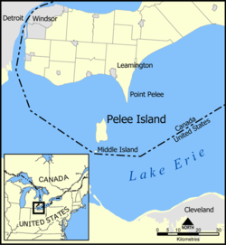
As well as forming along coastlines, cuspate forelands can also form along lake shores, although less is known about this type of cuspate foreland. This type of cuspate foreland includes Point Pelee along the shoreline of Lake Erie, and those found along the shoreline of Lake Victoria in Australia. There are two theories with regard to the formation of Point Pelee. Firstly, it is thought that Point Pelee has formed from depositional processes. Alternatively, it is suggested that Point Pelee is a relic of a past feature that has eroded over time. This gap in knowledge provides the opportunity for further research. It is likely that Point Pelee is migrating westwards since accretion is occurring on the western side, and erosion is occurring on the eastern side. Lake Victoria in Australia also has a number of cuspate forelands. Point Scott is a cuspate foreland along this lakeshore that has formed from the gradual accumulation of sand and gravel.Features
Cuspate forelands can be separated into three distinct areas: the central nose or apex, and two marginal wings. The apex usually has ridges that run parallel to the converging shorelines. Cuspate forelands can extend up to 5km from the shoreline, and an underwater shoal may extend much further, up to 15km from the exposed apex. Located between the mainland and the foreland are often lagoons or marshy areas. In some areas, such as along the North Carolina coastline, a series of cuspate forelands may form at least 100km apart. In areas that have a large amount of shingle, such as the cuspate foreland at Dungeness, it is also common for a fresh water tableWater table
The water table is the level at which the submarine pressure is far from atmospheric pressure. It may be conveniently visualized as the 'surface' of the subsurface materials that are saturated with groundwater in a given vicinity. However, saturated conditions may extend above the water table as...
to be present.
Movement
Once formed, cuspate forelands can remain where they are and continue to develop as sediment accumulates, or alternatively they may migrate down the coast as one side of the foreland erodes and the other side accretes. Cuspate Forelands that move are typical of those that are formed on open coastlines. The direction of migration is often indicated by a series of successive beach ridges on the advancing side of the foreland where there is less wave energy. The movement of cuspate forelands is commonly explained by longshore drift acting as the main process. However, there have been observed cases where two cuspate forelands on the same shoreline have migrated in opposite directions, showing that longshore drift does not always provide a sufficient explanation for their migration.If there is an offshore sandbank present, the position of the cuspate foreland is usually related to its position. If there is a change in the position of the sandbank, the position of the cuspate foreland typically follows. Not only does the sandbank act like an island since it causes waves to refract around it, but it also provides a source of sediment. As sand erodes from the sandbank, it is pushed towards the coastline, contributing to the formation of the cuspate foreland as the sandbank migrates along the coast. This often occurs in the opposite direction to longshore drift.
In the case of a cuspate foreland that has formed close to an island, it is possible for it to extend right up to the island, forming a tombolo
Tombolo
A tombolo, from the Italian tombolo, derived from the Latin tumulus, meaning 'mound,' and sometimes translated as ayre , is a deposition landform in which an island is attached to the mainland by a narrow piece of land such as a spit or bar. Once attached, the island is then known as a tied island...
. Depending on the physical conditions such as storms, the feature can alternate between a cuspate foreland and a tombolo. Gabo Island
Gabo Island
Gabo Island is a 154 ha island located off the coast of eastern Victoria, Australia, between Mallacoota and Cape Howe on the border with New South Wales. It is separated from the mainland by a 500 m wide channel; access is available by arranged flights and boats...
in South Australia is an example of where this occurs.
Succession
After the formation of the cuspate foreland into its distinctive triangular shape, it will start to be colonised by pioneer species that are hardy and tough enough to survive in the environment. These pioneer species secure the cuspate foreland and allow a greater amount of sediment to further secure it. Colonization and successionEcological succession
Ecological succession, is the phenomenon or process by which a community progressively transforms itself until a stable community is formed. It is a fundamental concept in ecology, and refers to more or less predictable and orderly changes in the composition or structure of an ecological community...
of vegetation is dependent on a number of factors. Firstly, if the shingle is too coarse, the amount of fine sediment that can remain between the spaces is reduced, and the likelihood that seeds will germinate and grow upwards is low. Seeds will also fail to germinate and grow if there is insufficient retention of fresh water. Stable cuspate forelands that are composed of shingle often have vegetation above the high tide line. As vegetation is established, mites and collembolans break down plant matter such as roots, resulting in the accumulation of organic matter. Plants also cause the soil to develop and water retention to increase, therefore providing a habitat where more plants can grow. Vegetation above the high tide line is common on cuspate forelands that are stable and composed of shingle.
Biological habitat
Cuspate forelands provide a habitat for various floraFlora
Flora is the plant life occurring in a particular region or time, generally the naturally occurring or indigenous—native plant life. The corresponding term for animals is fauna.-Etymology:...
and fauna
Fauna
Fauna or faunæ is all of the animal life of any particular region or time. The corresponding term for plants is flora.Zoologists and paleontologists use fauna to refer to a typical collection of animals found in a specific time or place, e.g. the "Sonoran Desert fauna" or the "Burgess shale fauna"...
. If a foreland is relatively stable and experiences low wave impact, it may be possible for vegetation to grow. In the United Kingdom, 11 taxa of invertebrates are found on shingle habitats. Shingle beaches also provide a habitat for birds to breed, nest, and rest en route while migrating.
Impacts and management
There are different management issues with regard to cuspate forelands depending on their formation. If a cuspate foreland has formed from deposition, it may be vulnerable if human interference alters the transport of sediments from the shoreline. However if the cuspate foreland is a relic of a past feature that has eroded, human interference with longshore sediment movement will not have a significant impact on the cuspate foreland. For a cuspate foreland to be maintained, the input of sediment must be greater than output of sediment. Activities such as coastal development or engineering must be regulated for sediment to continue moving towards the foreland where it can be deposited. Development along cuspate forelands is risky due to erosion and the vulnerability to storms and sea level rise. As sea levels rise, cuspate forelands are likely to be at risk as they could move inland.At Point Pelee, approximately 1,900 hectares of former agricultural land on the cuspate foreland is now under water as a result of wind erosion and compaction of organic soils on the foreland. This foreland is particularly vulnerable to erosion when high lake levels are combined with spring and autumn cyclonic activity. Erosion can also occur as spring storms cause ice to scour the lake bottom at the edge of the foreland. Because there is uncertainty about its formation, there is uncertainty with regard to management, although Parks Canada realises the importance of including Point Pelee National Park in management plans.
When there is an aquifer
Aquifer
An aquifer is a wet underground layer of water-bearing permeable rock or unconsolidated materials from which groundwater can be usefully extracted using a water well. The study of water flow in aquifers and the characterization of aquifers is called hydrogeology...
present under a cuspate foreland, regulation of water removal is required. At Dungeness, water restrictions have been put in place to maintain the aquifer level.
The management of coastlines needs to take into account the natural processes that occur on cuspate forelands since many provide a habitat
Habitat
* Habitat , a place where a species lives and grows*Human habitat, a place where humans live, work or play** Space habitat, a space station intended as a permanent settlement...
for birds. Alternative ways of managing coastal erosion is needed, such as the use of ‘soft’ defences instead of high impact defences such as sea walls. Some cuspate forelands naturally do not contain any vegetation due to a high level of disturbance from physical factors such as wave action. However with the frequency of storms arising from climate change, the effect on forelands and their associated vegetation needs to be effectively managed.
See also
- Integrated coastal zone managementIntegrated coastal zone managementIntegrated coastal zone management or Integrated coastal management is a process for the management of the coast using an integrated approach, regarding all aspects of the coastal zone, including geographical and political boundaries, in an attempt to achieve sustainability.This concept was born...
- Beach evolutionBeach evolutionThe shoreline is where the land meets the sea and it is continually changing. Over the long term, the water is eroding the land. Beaches represent a special case, in that they exist where sand accumulated from the same processes that strip away rocky and sedmientary material. I.e., they can grow as...
- Longshore transport
- Point Pelee National ParkPoint Pelee National Park-See also:*National Parks of Canada*List of National Parks of Canada*Long Point-External links:**...
External Links
- Point Pelee National Park, Parks Canada
- Dungeness National Nature Reserve, Romney Marsh Countryside Project
- Cuspate Forelands at Lakes Entrance, Department of Primary Industries