
Wicklow Mountains
Encyclopedia
The Wicklow Mountains form the largest continuous upland area in Ireland
. They occupy the whole centre of County Wicklow
and stretch outside its borders into Counties Carlow
, Wexford
and Dublin
. Where the mountains extend into County Dublin, they are known locally as the Dublin Mountains . The highest peak is Lugnaquilla
at 925 metres (3,034.8 ft).
The mountains are primarily composed of granite
surrounded by an envelope of mica
-schist
and much older rocks such as quartzite
. They were pushed up during the Caledonian orogeny
at the start of the Devonian
period and form part of the Leinster Chain, the largest continuous area of granite in Ireland and Britain. The mountains owe much of their present topography to the effects of the last ice age
, which deepened the valleys and created corrie
and ribbon
lakes. Copper
and lead
have been the main metals mined in the mountains and a brief gold rush
occurred in the 18th century.
Several major river systems
have their source in the mountains, such as the Liffey
, Dargle, Slaney
and Avoca
rivers. Powerscourt Waterfall
is the tallest in Ireland at 121 metres (397 ft). A number of these rivers have been harnessed to create reservoir
s for drinking water
for Dublin and its surroundings.
The Wicklow Mountains experience a temperate
oceanic climate
with mild, damp summers and cool, wet winters. The dominant habitat of the uplands consists of blanket bog
, heath
and upland grassland
. The uplands support a number of threatened bird species, including merlin
and peregrine falcon
. The valleys are a mixture of coniferous and deciduous
woodland.
The mountains have been inhabited since Neolithic
times and a number of typical monuments, in particular a series of passage tombs, survive to the present day. The monastery
at Glendalough
, founded in the late 6th century by Saint Kevin
, was an important centre of the Early Church in Ireland
. Following the Norman
invasion in the 12th century, the Wicklow Mountains became a stronghold and hiding place for Irish clan
s opposed to English rule. The O'Byrne
and O'Toole families carried out a campaign of harassment against the settlers for almost five centuries. Later the mountains harboured rebels during the 1798 Rising
. Rebel activity died out after the construction of the Wicklow Military Road
at the start of the 19th century and the mountains began to attract tourists
to the ruins at Glendalough and to admire the mountain scenery.
The Wicklow Mountains continue to be a major attraction for tourism and recreation. The entire upland area is designated as a Special Area of Conservation
and as a Special Protection Area
under European Union
law. The Wicklow Mountains National Park
was established in 1991 to conserve the local biodiversity
and landscape.
which in turn takes its name from Wicklow Town
. The origin of the name is from the Danish
Wykynglo or Wykinlo. The Irish name for Wicklow, , means "Church of Mantan", named after an apostle of Saint Patrick
. Wicklow was not established as a county until 1606; prior to that it had been part of County Dublin
. An early name for the whole area of the Wicklow Mountains was Cualu. There are also historic names for various territories in the mountains held by local clan
s: the north part of Wicklow and south Dublin was known as Cualann while the Glen of Imaal
takes its name from the territory of Hy Mail. A sept
of the O'Byrne family
called the Gaval Rannall possessed the area around Glenmalure
, known as Gaval-Rannall or Ranelagh. During the medieval period, prior to the establishment of County Wicklow, the English administration in Dublin referred to the region as the Leinster Mountains.
and extend into Counties Dublin
, Carlow
and Wexford
. The general direction of the mountain ranges is from north-east to south-west. They are formed into several distinct groups: that of Kippure
in the north, on the boundary of Dublin and Wicklow; Djouce
, Tonelagee
, Camaderry
and Lugnaquilla
in the centre; Church Mountain
and Keadeen in the west; and Croghan Kinsella
to the south. To the east, separated from the rest of the range by the Vartry Plateau, is the group comprising the Great Sugar Loaf
, Little Sugar Loaf
and Bray Head
.
Lugnaquilla
is the highest peak in the Wicklow Mountains at 925 metres (3,034.8 ft) and the 13th highest in Ireland. It is also the highest peak in Leinster
and is the only Irish Munro
to be found outside of Munster
. Kippure
, at 757 metres (2,483.6 ft), is the highest mountain in County Dublin. There are a total of 39 peaks over 600 metres (1,968.5 ft) in the Wicklow Mountains. There are only three passes through the mountains under 600 metres (1,968.5 ft) with the Sally Gap
(1634 feet (498 m)) and the Wicklow Gap
(1567 feet (477.6 m)) being the highest road passes in the country.
surrounded by an envelope of mica
-schist
and much older rocks such as quartzite
. The oldest rocks are the quartzites of the Bray Group that include Bray Head
and the Little Sugar Loaf
and Great Sugar Loaf
mountains. These metamorphosed
from sandstone
deposited in the deep waters of the primeval Iapetus Ocean
during the Cambrian
period (542-488 million years ago). Layers of sediment continued to form slate
s and shales
along the ocean floor mixed with volcanic rock
pushed up as Iapetus began to shrink by the process of subduction
during the Ordovician
period (488-443 million years ago). These rocks now underlie the uplifted peneplain
of the Vartry Plateau between the Bray Group and the main range.
Iapetus closed up completely at the end of the Silurian
period (443-415 million years ago) and the Wicklow Mountains were uplifted
during the main phase of the Caledonian orogeny
at the start of the Devonian
period (415-358 million years ago) when the continents of Baltica
and Laurentia
collided
. The collision pushed up a large batholith
of granite, known as the Leinster Chain: this is the largest continuous area of granite in Ireland and Britain and runs from the coast at Dun Laoghaire
in County Dublin to New Ross
in County Wexford and includes the Wicklow and Blackstairs
Mountains. The heat generated by the collision metamorphosed the slates and shales surrounding the granite into schist
s which formed an aureole (shell) around the granite. The process of erosion
has removed much of the surrounding schist from the mountain tops, exposing the underlying granite. Some remnants of the schist roof remain on some of the mountain tops, most notably Lugnaquilla
. The round granite topped peaks contrast with the sharper schist peaks: for example, War Hill
(granite) and Djouce
(schist).
The last major geological event to shape the Wicklow Mountains was the Quaternary glaciation
during the Pleistocene
epoch
(2.6 million to 11,700 years ago). The ice deepened
and moulded the valleys into the U-shape
that characterises the Wicklow Glens, such as Glendalough
and Glenmacnass. As the ice melted, small glaciers were left in corries
where moraine
s now dam lakes such as at Loughs Bray and Nahanagan. Corries without lakes also occur, such as the North Prison and South Prison of Lugnaquilla. Escaping meltwater
cut narrow rocky gorges at several locations including the Glen of the Downs
, the Devil’s Glen and The Scalp. Ribbon lake
s, such as Lough Dan
and the lakes of Glendalough, also formed.
and the formation of Ireland's most significant metalliferous belt. The most important mining sites have been at Avoca
and Glendalough
. Mining has taken place at Avoca since at least the Bronze Age
(c. 2,500-600 BCE). Iron ore extraction took place between the 12th and 17th centuries before being replaced by lead
mining up to the mid 18th century. The principal activity from 1720 to the closure of the last mine in 1982 was copper extraction. Sulphur has also been extracted at certain times and, in smaller quantities, gold
, silver
and zinc
. Lead mining has been the principal activity in the Glendalough valley and its neighbouring valleys of Glendasan and Glenmalure. Lead was first discovered in Glendasan in the early 19th century and the lead veins were later followed through Camaderry
mountain to Glendalough. Mining on a smaller scale took place in Glenmalure. Ore from these mines was shipped to Ballycorus for processing. The last mine closed in 1957.
In 1795, a local schoolmaster discovered gold
in the Aughatinavought River, a tributary of the River Aughrim
since renamed Gold Mines River that rises on the slopes of Croghan Kinsella
mountain. During the subsequent gold rush
, some 80 kilograms (176.4 lb) of gold was recovered from the river by local prospectors, including a single nugget weighing 682 grams (24.1 oz), the largest lump of gold ever discovered in Ireland and Britain. The mine workings were subsequently seized by the British government who extracted a further 300 kilograms (661.4 lb) of gold. Various attempts have been made to locate the motherlode on Croghan Kinsella but to no avail.
Granite from the Wicklow Mountains has been used as a material for many buildings in Wicklow and Dublin and beyond. The quarries at Ballyknockan
have provided material for buildings such as the Bank of Ireland
on College Green
in Dublin, Dun Laoghaire
lighthouse and Liverpool Cathedral
. Similarly, quarries at Glencullen
provided stone for such buildings as the G. P. O.
on O'Connell Street
and the Industry and Commerce building on Kildare Street
in Dublin. Barnacullia, on the slopes of Three Rock Mountain, supplied paving stones to Dublin Corporation
. The quarry at Dalkey
supplied granite for Dun Laoghaire Harbour and the Thames Embankment
.
. Since the thin blanket bog
peat
s cannot hold great quantities of water, many of these rivers exhibit a flashy hydrograph
y, filling rapidly after heavy rain.
The River Liffey
rises between the mountains of Kippure
and Tonduff at Liffey Head Bog. One of the major tributaries
of the Liffey, the River Dodder
, rises nearby on slopes on Kippure
. The King's River rises on Mullaghcleevaun
and joins the Liffey near Blessington
.
The River Vartry
rises on the slopes of Djouce mountain. Nearby, the River Dargle rises between Tonduff and War Hill, falling as the Powerscourt Waterfall
, Ireland's tallest waterfall at 121 metres (397 ft), over a cliff formed by a glacier at the contact point between the granite and mica-schist of the Wicklow Mountains. The waterfalls at the heads of the valleys of Glendalough, Glenmacnass and Glendasan also occur approximately at the schist-granite junctions, as does the Carrawaystick waterfall in Glenmalure
.
The River Slaney
rises in the North Prison of Lugnaquilla mountain and winds through the Glen of Imaal
where it is joined by the Leoh, Knickeen and Little Slaney. Another of its tributaries, the River Derreen, rises on Lugnaquilla’s southern side.
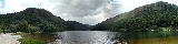
Each of the main branches of the River Avoca
– the Avonmore
, the Avonbeg
and the Aughrim
rivers – have their origins in smaller tributaries, many of which rise in the Wicklow Mountains. The Glenealo, Glendasan and Annamoe rivers meet to form the Avonmore near Laragh
. The Annamoe rises near Sally Gap and is joined by Cloghoge Brook between Lough Tay
and Lough Dan
and by the River Inchavore in Lough Dan. The Avonbeg rises on Table Mountain
and the Three Lakes. The Avonmore and Avonbeg rivers join to form the River Avoca at the Meeting of the Waters in the Vale of Avoca
, celebrated in the song The Meeting of the Waters by Thomas Moore
. The Avoca is joined by the River Aughrim at Woodenbridge, sometimes referred to as the “Second Meeting of the Waters”. The Aughrim is formed at the junction of the Derry Water and the River Ow, the latter of which rises on Lugnaquilla.
med to create reservoir
s to provide drinking water
for the residents of Dublin and its environs. The first of these was the River Vartry, dammed to create the Vartry Reservoir
near Roundwood
in the 1860s. A second dam was added in 1924 to increase capacity. The River Dodder feeds the two Bohernabreena reservoirs in the northern foothills of the Wicklow Mountains at Glenasmole in County Dublin, which were constructed between 1883 and 1887 to supply water to the townland
of Rathmines
. The Poulaphouca Reservoir
, on the River Liffey near Blessington, was constructed between 1938 and 1940. There are also two hydroelectricity
plants at Poulaphouca, constructed during the 1940s. A pumped storage hydroelectricity plant was constructed at Turlough Hill between 1968 and 1974. Water is pumped up from Lough Nanahangan, a natural corrie lake, into an artificial reservoir on Tomaneena mountain and released at times of peak electricity demand.
oceanic climate
with mild, damp summers and cool, wet winters. Annual rainfall reaches 2000 millimetres (78.7 in) on the highest mountains with the more westerly peaks getting the most rainfall (for example, Djouce mountain, in the east, receives c. 1630 millimetres (64.2 in) whereas Duff Hill
, in the west, receives c. 1950 millimetres (76.8 in) a year). June and July are generally the driest months and there is an average of four hours of sunshine a day over the entire year. Snow cover in winter can reach an average of 30 days a year on the highest peaks. Strong winds are an important factor in peat erosion on the summits.
of the uplands consists of heath
and bog
. The mountain blanket bog
s formed around 4,000 years ago as a result of a combination of climate change
and human activity. Prior to this, the mountains were cloaked with pine forest. A change in the climate to wetter and milder weather left the ground waterlogged and leached nutrients from the soil, leading to the formation of peat
. Mountain blanket bog is found in areas above 200 metres (656.2 ft) in altitude and where there are more than 175 days rainfall a year. The most important builders of peat are the Sphagnum
bog mosses. Carnivorous plant
s such as sundews and butterworts
are specific to boglands and bog asphodel and bog cotton are also common. Bog water is important for the reproduction of dragonflies
and damselflies
and the Wicklow mountain bogs also support insects such as pond skaters, whirligig beetle
s, water boatmen
and midge
s as well as the common frog
and the viviparous lizard
. Wading birds
such as snipe
s, curlew
s and golden plover
feed in the waterlogged bogland.
Due to drainage of water from the bogs as a result of human activity, most of Wicklow's peat has dried out too much for Sphagnum mosses to grow and moorland
and heath
vegetation has taken over. Active peat building is still occurring at some sites, most notably the Liffey Head Bog. Common heather
(or ling) and bell heather
are the most common moorland plants along with bilberry
(or fraughan, as it is known in Ireland), bog cotton, deergrass
and purple moor grass. Bird species found on the Wicklow moorland include red grouse
, meadow pipit
and skylark
. Birds of prey found in the uplands include kestrel
s, hen harrier
s, merlins
and peregrine falcon
s. The latter of these are protected species. The uplands are used for sheep grazing
and so the moorland is periodically burned to keep the growth of heather in check and encourage growth of grasses.
Red deer
, once native to Wicklow but hunted to extinction, were reintroduced on the Powerscourt Estate
in the 18th century. Japan
ese sika deer
were also imported by the Powerscourt Estate and have interbred with the red deer. All deer found in the Wicklow Mountains are descended from the Powerscourt herd and are either sika deer or hybrid red-sika deer. Other mammals occurring include feral goat
s, mountain hare
s, badger
s, stoat
s, otter
s, red squirrel
s, grey squirrel
s and bat
s. The Irish Elk
is an extinct species of deer that lived in the Wicklow Mountains c. 11,000 years ago, remains of which were discovered in great quantities in Ballybetagh Bog near Glencullen
. Wolves
were also once native to the mountains but hunted to extinction in Ireland: the last wolf in Wicklow was killed at Glendalough in 1710.
Widespread clearance of forest began in the Bronze Age and continued up until the early 20th century. Afforestation
programmes began in the 1920s and accelerated in the 1950s with the widespread planting of conifer
forest, especially in upland moorland areas previously considered unsuitable for planting. The dominant tree is the sitka spruce
, accounting for 58% of forest plantations, with lodgepole pine
, Norway spruce
, Scots pine
, larch
and Douglas fir also planted. Biodiversity
is low in the conifer plantations because they are not native tree species. Broadleaf
plantations are rare, accounting for less than 10% of forest.
The young rivers in the upper glens are spawning
grounds for salmon
and brown trout
. Arctic char
, isolated in the Wicklow lakes following the end of the last ice age, have been recorded in Lough Dan and the lakes of Glendalough but are now believed extinct. A programme to reintroduce them into the Upper Lake at Glendalough commenced in 2009.
period, are the earliest and most prominent feature of prehistoric Irish civilisation in the Wicklow Mountains. These tombs sit on many of the western and northern summits between Saggart
in Dublin and Baltinglass
in Wicklow, such as at Seefin
and Seefingan
. Archaeologist Geraldine Stout has suggested they had a territorial marking function, much like modern-day border posts. Other prehistoric monuments to be found in the uplands include stone circle
s, standing stones and rock art
. The presence of standing stones at altitudes suggests they may have served route-marking purposes. The largest complex of hill fort
s in Ireland is to be found on the hills near Baltinglass.
The earliest known tribes to have controlled the Wicklow Mountains include the Dál Messin Corb, the Uí Mail, the Uí Theig and the Uí Briúin. One member of the Dál Messin Corb was Saint Kevin
, who founded the monastery
at Glendalough
in the latter part of the 6th century. Kevin travelled to Glendalough from Hollywood
, crossing the mountains via the Wicklow Gap. By the 8th century, Glendalough had grown into a substantial settlement of 500-1,000 people and an important site of learning and pilgrimage
. Monasteries were often attacked, especially at times of disease or famine, and Glendalough's wealth made it a frequent target for both local tribes and, later, Norse
invaders. The monastery declined in importance after the arrival of the Normans
in the 12th century and its subsequent annexation to the Archdiocese of Dublin
. It was burned by the English in 1398, although settlement there continued until the end of the 16th century. There are also important early Irish church sites in the Dublin foothills of the Wicklow Mountains at Rathmichael and Tully.
In 1170, during the Norman invasion of Ireland
, Strongbow
and Dermot MacMurrough
successfully laid siege to Dublin by following a high route through the Wicklow Mountains, avoiding the defences along the normal route to the west of the mountains. The Norman invasion displaced two important Gaelic
clan
s from Kildare
, the O'Byrnes
and the O'Tooles, who moved into the Wicklow Mountains, the O'Byrnes in the east and the O'Tooles in the west. From their mountain strongholds both families conducted a persistent campaign of harassment against the invaders and the Wicklow Mountains became known as the terra guerre (“land of war”), as opposed to the terra pacis (“land of peace”) of the settled lowlands.
The valley of Glenmalure
provided an almost unassailable refuge for the clans and English forces suffered heavy defeats there, first in 1274 and again in 1580 in the Battle of Glenmalure
. The latter defeat was at the hands of Fiach McHugh O'Byrne
, who led many attacks against the English and assisted in the escapes of many of the hostages held by the English to guarantee the loyalty of the Irish clans. One such hostage was Red Hugh O'Donnell
, who escaped from Dublin Castle
on the night of 6 January 1592 in the company of Art O'Neill. The two men crossed the mountains in blizzard conditions, making for Fiach McHugh O'Byrne's stronghold at Glenmalure. Art O'Neill died from exposure
during the journey and Red Hugh had several toes amputated due to frostbite
. A cross and a plaque to the north of Conavalla
mountain mark the place where Art O'Neill perished and an annual walk is now held following in the two men's footsteps. The O'Byrnes' and O'Tooles' dominance finally came to an end with the Act of Succession
of 1652 when their land was confiscated by the English Commonwealth.
A prolonged period of peace reigned in the Wicklow Mountains from the end of the Cromwellian period
until the 1798 Rising
. Although the main rebellion was quickly defeated, Irish rebels once again used the Wicklow Mountains as a hiding place and stronghold to attack the English for many years afterwards. Among their number was Michael Dwyer
, a native of the Wicklow Mountains, born in the townland
of Camara in the Glen of Imaal
, and General Joseph Holt
. Both men eventually surrendered and were transported
to Australia
. Determined to prevent any future rebel activity, a military road through the mountains, similar to those built in the Scottish Highlands
to quell the Jacobite risings, was proposed by the British government to enable troops to be deployed quickly into the region. The Wicklow Military Road
was constructed between 1800 and 1809 and runs from Rathfarnham
, County Dublin to Aghavannagh
, County Wicklow via Glencree
, the Sally Gap and Laragh
. A series of army barracks and police stations were built along the route, although they were little used and soon fell into disrepair as the Wicklow Mountains soon ceased to be a centre of rebel activity after the road was completed.
The census
of 1841 recorded a population of 13,000 in the Wicklow uplands out of 126,143 persons in the county as a whole. Following the Great Famine, the census of 1891 showed the population of County Wicklow had declined to 62,136 with the proportionate fall in the uplands regions even greater as the populace deserted the marginal lands.
The construction of the railways
in the 19th century led to the development of tourism
in the Wicklow Mountains. Visitors were taken by horse-drawn transport into the mountains from the railway station at Rathdrum
. Glendalough quickly established itself as the most popular tourist destination and a train service there was considered in 1897 but the proposals came to nothing. The tourism potential of the Military Road was spotted soon after its completion and G. N. Wright's Tours in Ireland (1822) is one of the earliest guides to the sights along the route.
, using mainly the Wicklow Cheviot
breed. Land is also used for forestry
and turf cutting
. Tourism and recreation are also major activities in the uplands. Glendalough remains the most popular destination, receiving around one million visitors each year. Recreational activities in the mountains include walking, rock climbing
, fishing
and cycling
. Hillwalking
in the Wicklow Mountains was first popularised by J. B. Malone
through a weekly column he wrote in the Evening Herald
newspaper. Malone was later instrumental in the creation of the Wicklow Way
, Ireland's first National Waymarked Trail
, which opened in 1980 and crosses the Wicklow Mountains. The Wicklow Way has been joined by the Dublin Mountains Way
and the Saint Kevin's Way
pilgrim path, both of which also traverse parts of the mountains.
On foot of concerns about environmental degradation and undesirable development of the Wicklow Uplands, the Government announced the creation of the Wicklow Mountains National Park
in 1990 to conserve the area's biodiversity and landscape. The park was officially established in 1991 and now encompasses an area of over 20000 ha (200 km²; 77.2 sq mi). In addition, the Wicklow Mountains (including areas outside the National Park) are classed as a Special Area of Conservation
under the EU
Habitats Directive and as a Special Protection Area
under the EU Birds Directive
.
The Dublin foothills of the Wicklow Mountains are managed by the Dublin Mountains Partnership (DMP), a group established in May 2008 with the aim of improving the recreational experience of users of the Dublin Mountains. Its members include representatives of state agencies, local authorities and recreational users. The DMP has restored paths and developed walking trails, orienteering
courses and a mountain biking
course.
Republic of Ireland
Ireland , described as the Republic of Ireland , is a sovereign state in Europe occupying approximately five-sixths of the island of the same name. Its capital is Dublin. Ireland, which had a population of 4.58 million in 2011, is a constitutional republic governed as a parliamentary democracy,...
. They occupy the whole centre of County Wicklow
County Wicklow
County Wicklow is a county in Ireland. It is part of the Mid-East Region and is also located in the province of Leinster. It is named after the town of Wicklow, which derives from the Old Norse name Víkingalág or Wykynlo. Wicklow County Council is the local authority for the county...
and stretch outside its borders into Counties Carlow
County Carlow
County Carlow is a county in Ireland. It is part of the South-East Region and is also located in the province of Leinster. It is named after the town of Carlow, which lies on the River Barrow. Carlow County Council is the local authority for the county...
, Wexford
County Wexford
County Wexford is a county in Ireland. It is part of the South-East Region and is also located in the province of Leinster. It is named after the town of Wexford. In pre-Norman times it was part of the Kingdom of Uí Cheinnselaig, whose capital was at Ferns. Wexford County Council is the local...
and Dublin
County Dublin
County Dublin is a county in Ireland. It is part of the Dublin Region and is also located in the province of Leinster. It is named after the city of Dublin which is the capital of Ireland. County Dublin was one of the first of the parts of Ireland to be shired by King John of England following the...
. Where the mountains extend into County Dublin, they are known locally as the Dublin Mountains . The highest peak is Lugnaquilla
Lugnaquilla
Lugnaquilla or Lugnaquillia, historically called Lugnaculliagh is a mountain in County Wicklow, Republic of Ireland. It is the highest peak of the Wicklow Mountains range, the highest in the province of Leinster, and the 13th highest peak in Ireland and affectionately known as "Lug".Views, on a...
at 925 metres (3,034.8 ft).
The mountains are primarily composed of granite
Granite
Granite is a common and widely occurring type of intrusive, felsic, igneous rock. Granite usually has a medium- to coarse-grained texture. Occasionally some individual crystals are larger than the groundmass, in which case the texture is known as porphyritic. A granitic rock with a porphyritic...
surrounded by an envelope of mica
Mica
The mica group of sheet silicate minerals includes several closely related materials having highly perfect basal cleavage. All are monoclinic, with a tendency towards pseudohexagonal crystals, and are similar in chemical composition...
-schist
Schist
The schists constitute a group of medium-grade metamorphic rocks, chiefly notable for the preponderance of lamellar minerals such as micas, chlorite, talc, hornblende, graphite, and others. Quartz often occurs in drawn-out grains to such an extent that a particular form called quartz schist is...
and much older rocks such as quartzite
Quartzite
Quartzite is a hard metamorphic rock which was originally sandstone. Sandstone is converted into quartzite through heating and pressure usually related to tectonic compression within orogenic belts. Pure quartzite is usually white to gray, though quartzites often occur in various shades of pink...
. They were pushed up during the Caledonian orogeny
Caledonian orogeny
The Caledonian orogeny is a mountain building era recorded in the northern parts of the British Isles, the Scandinavian Mountains, Svalbard, eastern Greenland and parts of north-central Europe. The Caledonian orogeny encompasses events that occurred from the Ordovician to Early Devonian, roughly...
at the start of the Devonian
Devonian
The Devonian is a geologic period and system of the Paleozoic Era spanning from the end of the Silurian Period, about 416.0 ± 2.8 Mya , to the beginning of the Carboniferous Period, about 359.2 ± 2.5 Mya...
period and form part of the Leinster Chain, the largest continuous area of granite in Ireland and Britain. The mountains owe much of their present topography to the effects of the last ice age
Quaternary glaciation
Quaternary glaciation, also known as the Pleistocene glaciation, the current ice age or simply the ice age, refers to the period of the last few million years in which permanent ice sheets were established in Antarctica and perhaps Greenland, and fluctuating ice sheets have occurred elsewhere...
, which deepened the valleys and created corrie
Cirque
Cirque may refer to:* Cirque, a geological formation* Makhtesh, an erosional landform found in the Negev desert of Israel and Sinai of Egypt*Cirque , an album by Biosphere* Cirque Corporation, a company that makes touchpads...
and ribbon
Ribbon lake
A ribbon lake or loch is a long and narrow, finger-shaped lake, usually found in a glacial trough. Its formation begins when a glacier moves over an area containing alternate bands of hard and soft bedrock...
lakes. Copper
Copper
Copper is a chemical element with the symbol Cu and atomic number 29. It is a ductile metal with very high thermal and electrical conductivity. Pure copper is soft and malleable; an exposed surface has a reddish-orange tarnish...
and lead
Lead
Lead is a main-group element in the carbon group with the symbol Pb and atomic number 82. Lead is a soft, malleable poor metal. It is also counted as one of the heavy metals. Metallic lead has a bluish-white color after being freshly cut, but it soon tarnishes to a dull grayish color when exposed...
have been the main metals mined in the mountains and a brief gold rush
Gold rush
A gold rush is a period of feverish migration of workers to an area that has had a dramatic discovery of gold. Major gold rushes took place in the 19th century in Australia, Brazil, Canada, South Africa, and the United States, while smaller gold rushes took place elsewhere.In the 19th and early...
occurred in the 18th century.
Several major river systems
Drainage system (Geomorphology)
In geomorphology, a drainage system is the pattern formed by the streams, rivers, and lakes in a particular drainage basin. They are governed by the topography of the land, whether a particular region is dominated by hard or soft rocks, and the gradient of the land. Geomorphologists and...
have their source in the mountains, such as the Liffey
River Liffey
The Liffey is a river in Ireland, which flows through the centre of Dublin. Its major tributaries include the River Dodder, the River Poddle and the River Camac. The river supplies much of Dublin's water, and a range of recreational opportunities.-Name:The river was previously named An Ruirthech,...
, Dargle, Slaney
River Slaney
The Slaney is a river in the southeast of Ireland. It rises on Lugnaquilla Mountain in the western Wicklow Mountains and flows west and then south through counties Wicklow, Carlow and Wexford, before entering St George's Channel in the Irish Sea at Wexford town...
and Avoca
River Avoca
The Avoca is a river in County Wicklow, Ireland. It is contained completely within the county.The Avoca starts life as two rivers, the Avonmore and the Avonbeg...
rivers. Powerscourt Waterfall
Powerscourt Waterfall
Powerscourt Waterfall is a waterfall near Enniskerry, County Wicklow, in Ireland, located in a valley surrounded by Djouce Mountain and the Great Sugar Loaf...
is the tallest in Ireland at 121 metres (397 ft). A number of these rivers have been harnessed to create reservoir
Reservoir
A reservoir , artificial lake or dam is used to store water.Reservoirs may be created in river valleys by the construction of a dam or may be built by excavation in the ground or by conventional construction techniques such as brickwork or cast concrete.The term reservoir may also be used to...
s for drinking water
Drinking water
Drinking water or potable water is water pure enough to be consumed or used with low risk of immediate or long term harm. In most developed countries, the water supplied to households, commerce and industry is all of drinking water standard, even though only a very small proportion is actually...
for Dublin and its surroundings.
The Wicklow Mountains experience a temperate
Temperate
In geography, temperate or tepid latitudes of the globe lie between the tropics and the polar circles. The changes in these regions between summer and winter are generally relatively moderate, rather than extreme hot or cold...
oceanic climate
Oceanic climate
An oceanic climate, also called marine west coast climate, maritime climate, Cascadian climate and British climate for Köppen climate classification Cfb and subtropical highland for Köppen Cfb or Cwb, is a type of climate typically found along the west coasts at the middle latitudes of some of the...
with mild, damp summers and cool, wet winters. The dominant habitat of the uplands consists of blanket bog
Blanket bog
Blanket bog or blanket mire is an area of peatland, forming where there is a climate of high rainfall and a low level of evapotranspiration, allowing peat to develop not only in wet hollows but over large expanses of undulating ground. The blanketing of the ground with a variable depth of peat...
, heath
Heath
-Habitats:* Heath or heathland, low-growing woody vegetation, mostly consisting of heathers and related species* Heaths in the British National Vegetation Classification system...
and upland grassland
Grassland
Grasslands are areas where the vegetation is dominated by grasses and other herbaceous plants . However, sedge and rush families can also be found. Grasslands occur naturally on all continents except Antarctica...
. The uplands support a number of threatened bird species, including merlin
Merlin (bird)
The Merlin is a small species of falcon from the Northern Hemisphere. A bird of prey once known colloquially as a pigeon hawk in North America, the Merlin breeds in the northern Holarctic; some migrate to subtropical and northern tropical regions in winter.-European and North American...
and peregrine falcon
Peregrine Falcon
The Peregrine Falcon , also known as the Peregrine, and historically as the Duck Hawk in North America, is a widespread bird of prey in the family Falconidae. A large, crow-sized falcon, it has a blue-gray back, barred white underparts, and a black head and "moustache"...
. The valleys are a mixture of coniferous and deciduous
Temperate deciduous forest
A temperate deciduous forest, more precisely termed temperate broadleaf forest or temperate broadleaved forest, is a biome found in North America, southern South America, Europe, and Asia. A temperate deciduous forest consists of trees that lose their leaves every year...
woodland.
The mountains have been inhabited since Neolithic
Neolithic
The Neolithic Age, Era, or Period, or New Stone Age, was a period in the development of human technology, beginning about 9500 BC in some parts of the Middle East, and later in other parts of the world. It is traditionally considered as the last part of the Stone Age...
times and a number of typical monuments, in particular a series of passage tombs, survive to the present day. The monastery
Monastery
Monastery denotes the building, or complex of buildings, that houses a room reserved for prayer as well as the domestic quarters and workplace of monastics, whether monks or nuns, and whether living in community or alone .Monasteries may vary greatly in size – a small dwelling accommodating only...
at Glendalough
Glendalough
Glendalough or Glendaloch is a glacial valley in County Wicklow, Ireland. It is renowned for its Early Medieval monastic settlement founded in the 6th century by St Kevin, a hermit priest, and partly destroyed in 1398 by English troops....
, founded in the late 6th century by Saint Kevin
Kevin of Glendalough
Saint Cóemgen , popularly anglicized to Kevin is an Irish saint who was known as the founder and first abbot of Glendalough in County Wicklow, Ireland.-Life:...
, was an important centre of the Early Church in Ireland
Celtic Christianity
Celtic Christianity or Insular Christianity refers broadly to certain features of Christianity that were common, or held to be common, across the Celtic-speaking world during the Early Middle Ages...
. Following the Norman
Normans
The Normans were the people who gave their name to Normandy, a region in northern France. They were descended from Norse Viking conquerors of the territory and the native population of Frankish and Gallo-Roman stock...
invasion in the 12th century, the Wicklow Mountains became a stronghold and hiding place for Irish clan
Clan
A clan is a group of people united by actual or perceived kinship and descent. Even if lineage details are unknown, clan members may be organized around a founding member or apical ancestor. The kinship-based bonds may be symbolical, whereby the clan shares a "stipulated" common ancestor that is a...
s opposed to English rule. The O'Byrne
O'Byrne family
The O'Byrne family is an Irish clann that descend from Bran mac Máelmórda, King of Leinster, of the Uí Faelain of the Uí Dúnlainge. During the Norman invasion of Ireland they lost their ancestral lands around Kildare and settled in south Wicklow in the late 12th century.The seat of the junior sept...
and O'Toole families carried out a campaign of harassment against the settlers for almost five centuries. Later the mountains harboured rebels during the 1798 Rising
Irish Rebellion of 1798
The Irish Rebellion of 1798 , also known as the United Irishmen Rebellion , was an uprising in 1798, lasting several months, against British rule in Ireland...
. Rebel activity died out after the construction of the Wicklow Military Road
R115 road
The R115 road is a regional road in counties Dublin and Wicklow in Ireland. It follows the Military Road for its entire length. The R115 is long; the full length of the Military Road is...
at the start of the 19th century and the mountains began to attract tourists
Tourism
Tourism is travel for recreational, leisure or business purposes. The World Tourism Organization defines tourists as people "traveling to and staying in places outside their usual environment for not more than one consecutive year for leisure, business and other purposes".Tourism has become a...
to the ruins at Glendalough and to admire the mountain scenery.
The Wicklow Mountains continue to be a major attraction for tourism and recreation. The entire upland area is designated as a Special Area of Conservation
Special Area of Conservation
A Special Area of Conservation is defined in the European Union's Habitats Directive , also known as the Directive on the Conservation of Natural Habitats and of Wild Fauna and Flora...
and as a Special Protection Area
Special Protection Area
A Special Protection Area or SPA is a designation under the European Union Directive on the Conservation of Wild Birds.Under the Directive, Member States of the European Union have a duty to safeguard the habitats of migratory birds and certain particularly threatened birds.Together with Special...
under European Union
European Union
The European Union is an economic and political union of 27 independent member states which are located primarily in Europe. The EU traces its origins from the European Coal and Steel Community and the European Economic Community , formed by six countries in 1958...
law. The Wicklow Mountains National Park
Wicklow Mountains National Park
Wicklow Mountains National Park is a protected area in County Wicklow, Ireland, one of six national parks in the country. The park is located in the Wicklow Mountains a short distance south of Dublin...
was established in 1991 to conserve the local biodiversity
Biodiversity
Biodiversity is the degree of variation of life forms within a given ecosystem, biome, or an entire planet. Biodiversity is a measure of the health of ecosystems. Biodiversity is in part a function of climate. In terrestrial habitats, tropical regions are typically rich whereas polar regions...
and landscape.
Toponymy
The Wicklow Mountains take their name from County WicklowCounty Wicklow
County Wicklow is a county in Ireland. It is part of the Mid-East Region and is also located in the province of Leinster. It is named after the town of Wicklow, which derives from the Old Norse name Víkingalág or Wykynlo. Wicklow County Council is the local authority for the county...
which in turn takes its name from Wicklow Town
Wicklow
Wicklow) is the county town of County Wicklow in Ireland. Located south of Dublin on the east coast of the island, it has a population of 10,070 according to the 2006 census. The town is situated to the east of the N11 route between Dublin and Wexford. Wicklow is also connected to the rail...
. The origin of the name is from the Danish
Danish language
Danish is a North Germanic language spoken by around six million people, principally in the country of Denmark. It is also spoken by 50,000 Germans of Danish ethnicity in the northern parts of Schleswig-Holstein, Germany, where it holds the status of minority language...
Wykynglo or Wykinlo. The Irish name for Wicklow, , means "Church of Mantan", named after an apostle of Saint Patrick
Saint Patrick
Saint Patrick was a Romano-Briton and Christian missionary, who is the most generally recognized patron saint of Ireland or the Apostle of Ireland, although Brigid of Kildare and Colmcille are also formally patron saints....
. Wicklow was not established as a county until 1606; prior to that it had been part of County Dublin
County Dublin
County Dublin is a county in Ireland. It is part of the Dublin Region and is also located in the province of Leinster. It is named after the city of Dublin which is the capital of Ireland. County Dublin was one of the first of the parts of Ireland to be shired by King John of England following the...
. An early name for the whole area of the Wicklow Mountains was Cualu. There are also historic names for various territories in the mountains held by local clan
Clan
A clan is a group of people united by actual or perceived kinship and descent. Even if lineage details are unknown, clan members may be organized around a founding member or apical ancestor. The kinship-based bonds may be symbolical, whereby the clan shares a "stipulated" common ancestor that is a...
s: the north part of Wicklow and south Dublin was known as Cualann while the Glen of Imaal
Glen of Imaal
The Glen of Imaal is a remote valley in the western Wicklow Mountains in Ireland. It is ringed by the Lugnaquilla massif and its foothills, including Table mountain and Keadeen...
takes its name from the territory of Hy Mail. A sept
Sept
A sept is an English word for a division of a family, especially a division of a clan. The word might have its origin from Latin saeptum "enclosure, fold", or it can be an alteration of sect.The term is found in both Ireland and Scotland...
of the O'Byrne family
O'Byrne family
The O'Byrne family is an Irish clann that descend from Bran mac Máelmórda, King of Leinster, of the Uí Faelain of the Uí Dúnlainge. During the Norman invasion of Ireland they lost their ancestral lands around Kildare and settled in south Wicklow in the late 12th century.The seat of the junior sept...
called the Gaval Rannall possessed the area around Glenmalure
Glenmalure
Glenmalure is a valley in the Wicklow Mountains in eastern Ireland. It is a u-shaped glacial valley, with only one road leading into it, which connects to the 'Military Road' at the mouth of the valley....
, known as Gaval-Rannall or Ranelagh. During the medieval period, prior to the establishment of County Wicklow, the English administration in Dublin referred to the region as the Leinster Mountains.
Topography
The Wicklow Mountains are the largest area of continuous high ground in Ireland, having an unbroken area of over 500 km² (193.1 sq mi) above 300 metres (1,000 feet). They occupy the centre of County WicklowCounty Wicklow
County Wicklow is a county in Ireland. It is part of the Mid-East Region and is also located in the province of Leinster. It is named after the town of Wicklow, which derives from the Old Norse name Víkingalág or Wykynlo. Wicklow County Council is the local authority for the county...
and extend into Counties Dublin
County Dublin
County Dublin is a county in Ireland. It is part of the Dublin Region and is also located in the province of Leinster. It is named after the city of Dublin which is the capital of Ireland. County Dublin was one of the first of the parts of Ireland to be shired by King John of England following the...
, Carlow
County Carlow
County Carlow is a county in Ireland. It is part of the South-East Region and is also located in the province of Leinster. It is named after the town of Carlow, which lies on the River Barrow. Carlow County Council is the local authority for the county...
and Wexford
County Wexford
County Wexford is a county in Ireland. It is part of the South-East Region and is also located in the province of Leinster. It is named after the town of Wexford. In pre-Norman times it was part of the Kingdom of Uí Cheinnselaig, whose capital was at Ferns. Wexford County Council is the local...
. The general direction of the mountain ranges is from north-east to south-west. They are formed into several distinct groups: that of Kippure
Kippure
Kippure is a granite mountain that straddles the county boundaries of South Dublin and Wicklow. It is popular for hill walking and outdoor leisure activity owing to its proximity to Dublin city, with its fine views over Dublin Bay towards Howth Head. It has convenient access and easy terrain...
in the north, on the boundary of Dublin and Wicklow; Djouce
Djouce
Djouce , sometimes referred to as Djouce Mountain, is a mountain situated in the northeastern section of the Wicklow Mountains. To the west it overlooks the highlands around the Sally Gap; to the east the Roundwood / Calary Bog plateau....
, Tonelagee
Tonelagee
Tonelagee is a mountain with a height of 817 m in County Wicklow, Republic of Ireland. It lies just north of the high point of the Wicklow Gap in the centre of the Wicklow Mountains. Tonelagee is the third highest of the Wicklow Mountains and the 33rd highest peak in Ireland...
, Camaderry
Camaderry
Camaderry is a mountain in the Wicklow Mountains, just south of the Wicklow Gap in County Wicklow, which runs over the gap between it and Tonelagee Mountain...
and Lugnaquilla
Lugnaquilla
Lugnaquilla or Lugnaquillia, historically called Lugnaculliagh is a mountain in County Wicklow, Republic of Ireland. It is the highest peak of the Wicklow Mountains range, the highest in the province of Leinster, and the 13th highest peak in Ireland and affectionately known as "Lug".Views, on a...
in the centre; Church Mountain
Church Mountain
Church Mountain, sometimes called Slievegad , is the most westerly of the Wicklow Mountains in Ireland. At the summit are the remains of a large cairn and an old triangulation pillar. Just east of the N81 national route, it lies roughly halfway between Hollywood to the north and Donard to the...
and Keadeen in the west; and Croghan Kinsella
Croghan Mountain
Croghan Kinsella is a mountain in the Wicklow Mountains, on the Wicklow/Wexford border.The Wexford 'River Bann' rises from its southern slopes.-External links:*...
to the south. To the east, separated from the rest of the range by the Vartry Plateau, is the group comprising the Great Sugar Loaf
Great Sugar Loaf
Often simply known as the Sugar Loaf , this mountain is located in the east of County Wicklow, in Ireland, south of Bray and to the north of the Glen of the Downs Nature Reserve...
, Little Sugar Loaf
Little Sugar Loaf
Little Sugar Loaf, also called Giltspur Mountain , is a hill in County Wicklow, Ireland. It is situated East-North-East of the Great Sugar Loaf, separated from it by the N11 dual carriageway...
and Bray Head
Bray Head
Bray Head is a hill and headland located in northern County Wicklow, Ireland, between the towns of Bray and Greystones. It forms part of the Wicklow Mountains and is a popular spot with hillwalkers. At the top of the head is a concrete cross which was placed there in 1950 during the holy year...
.
Lugnaquilla
Lugnaquilla
Lugnaquilla or Lugnaquillia, historically called Lugnaculliagh is a mountain in County Wicklow, Republic of Ireland. It is the highest peak of the Wicklow Mountains range, the highest in the province of Leinster, and the 13th highest peak in Ireland and affectionately known as "Lug".Views, on a...
is the highest peak in the Wicklow Mountains at 925 metres (3,034.8 ft) and the 13th highest in Ireland. It is also the highest peak in Leinster
Leinster
Leinster is one of the Provinces of Ireland situated in the east of Ireland. It comprises the ancient Kingdoms of Mide, Osraige and Leinster. Following the Norman invasion of Ireland, the historic fifths of Leinster and Mide gradually merged, mainly due to the impact of the Pale, which straddled...
and is the only Irish Munro
Munro
A Munro is a mountain in Scotland with a height over . They are named after Sir Hugh Munro, 4th Baronet , who produced the first list of such hills, known as Munros Tables, in 1891. A Munro top is a summit over 3,000 ft which is not regarded as a separate mountain...
to be found outside of Munster
Munster
Munster is one of the Provinces of Ireland situated in the south of Ireland. In Ancient Ireland, it was one of the fifths ruled by a "king of over-kings" . Following the Norman invasion of Ireland, the ancient kingdoms were shired into a number of counties for administrative and judicial purposes...
. Kippure
Kippure
Kippure is a granite mountain that straddles the county boundaries of South Dublin and Wicklow. It is popular for hill walking and outdoor leisure activity owing to its proximity to Dublin city, with its fine views over Dublin Bay towards Howth Head. It has convenient access and easy terrain...
, at 757 metres (2,483.6 ft), is the highest mountain in County Dublin. There are a total of 39 peaks over 600 metres (1,968.5 ft) in the Wicklow Mountains. There are only three passes through the mountains under 600 metres (1,968.5 ft) with the Sally Gap
R759 road
The R759 road is a regional road in Ireland that runs south-east to north-west through the Sally Gap in the Wicklow Mountains from the R755 near Roundwood in East Wicklow to the N81 in West Wicklow....
(1634 feet (498 m)) and the Wicklow Gap
R756 road
The R756 road is a regional road in Ireland running west-east from Dunlavin to Laragh. Its entire length is within County Wicklow crossing east/west through the Wicklow Gap ....
(1567 feet (477.6 m)) being the highest road passes in the country.
Geology
The Wicklow Mountains are primarily composed of graniteGranite
Granite is a common and widely occurring type of intrusive, felsic, igneous rock. Granite usually has a medium- to coarse-grained texture. Occasionally some individual crystals are larger than the groundmass, in which case the texture is known as porphyritic. A granitic rock with a porphyritic...
surrounded by an envelope of mica
Mica
The mica group of sheet silicate minerals includes several closely related materials having highly perfect basal cleavage. All are monoclinic, with a tendency towards pseudohexagonal crystals, and are similar in chemical composition...
-schist
Schist
The schists constitute a group of medium-grade metamorphic rocks, chiefly notable for the preponderance of lamellar minerals such as micas, chlorite, talc, hornblende, graphite, and others. Quartz often occurs in drawn-out grains to such an extent that a particular form called quartz schist is...
and much older rocks such as quartzite
Quartzite
Quartzite is a hard metamorphic rock which was originally sandstone. Sandstone is converted into quartzite through heating and pressure usually related to tectonic compression within orogenic belts. Pure quartzite is usually white to gray, though quartzites often occur in various shades of pink...
. The oldest rocks are the quartzites of the Bray Group that include Bray Head
Bray Head
Bray Head is a hill and headland located in northern County Wicklow, Ireland, between the towns of Bray and Greystones. It forms part of the Wicklow Mountains and is a popular spot with hillwalkers. At the top of the head is a concrete cross which was placed there in 1950 during the holy year...
and the Little Sugar Loaf
Little Sugar Loaf
Little Sugar Loaf, also called Giltspur Mountain , is a hill in County Wicklow, Ireland. It is situated East-North-East of the Great Sugar Loaf, separated from it by the N11 dual carriageway...
and Great Sugar Loaf
Great Sugar Loaf
Often simply known as the Sugar Loaf , this mountain is located in the east of County Wicklow, in Ireland, south of Bray and to the north of the Glen of the Downs Nature Reserve...
mountains. These metamorphosed
Metamorphism
Metamorphism is the solid-state recrystallization of pre-existing rocks due to changes in physical and chemical conditions, primarily heat, pressure, and the introduction of chemically active fluids. Mineralogical, chemical and crystallographic changes can occur during this process...
from sandstone
Sandstone
Sandstone is a sedimentary rock composed mainly of sand-sized minerals or rock grains.Most sandstone is composed of quartz and/or feldspar because these are the most common minerals in the Earth's crust. Like sand, sandstone may be any colour, but the most common colours are tan, brown, yellow,...
deposited in the deep waters of the primeval Iapetus Ocean
Iapetus Ocean
The Iapetus Ocean was an ocean that existed in the Neoproterozoic and Paleozoic eras of the geologic timescale . The Iapetus Ocean was situated in the southern hemisphere, between the paleocontinents of Laurentia, Baltica and Avalonia...
during the Cambrian
Cambrian
The Cambrian is the first geological period of the Paleozoic Era, lasting from Mya ; it is succeeded by the Ordovician. Its subdivisions, and indeed its base, are somewhat in flux. The period was established by Adam Sedgwick, who named it after Cambria, the Latin name for Wales, where Britain's...
period (542-488 million years ago). Layers of sediment continued to form slate
Slate
Slate is a fine-grained, foliated, homogeneous metamorphic rock derived from an original shale-type sedimentary rock composed of clay or volcanic ash through low-grade regional metamorphism. The result is a foliated rock in which the foliation may not correspond to the original sedimentary layering...
s and shales
Shalës
Shalës is a municipality in the Elbasan District, Elbasan County, central Albania. The municipality consists of the villages Shalës, Licaj, Kurtalli, Xibrake, Xherie and Kodras....
along the ocean floor mixed with volcanic rock
Volcanic rock
Volcanic rock is a rock formed from magma erupted from a volcano. In other words, it is an igneous rock of volcanic origin...
pushed up as Iapetus began to shrink by the process of subduction
Subduction
In geology, subduction is the process that takes place at convergent boundaries by which one tectonic plate moves under another tectonic plate, sinking into the Earth's mantle, as the plates converge. These 3D regions of mantle downwellings are known as "Subduction Zones"...
during the Ordovician
Ordovician
The Ordovician is a geologic period and system, the second of six of the Paleozoic Era, and covers the time between 488.3±1.7 to 443.7±1.5 million years ago . It follows the Cambrian Period and is followed by the Silurian Period...
period (488-443 million years ago). These rocks now underlie the uplifted peneplain
Peneplain
A peneplain is a low-relief plain representing the final stage of fluvial erosion during times of extended tectonic stability. The existence of peneplains, and peneplanation as a geomorphological process, is not without controversy, due to a lack of contemporary examples and uncertainty in...
of the Vartry Plateau between the Bray Group and the main range.
Iapetus closed up completely at the end of the Silurian
Silurian
The Silurian is a geologic period and system that extends from the end of the Ordovician Period, about 443.7 ± 1.5 Mya , to the beginning of the Devonian Period, about 416.0 ± 2.8 Mya . As with other geologic periods, the rock beds that define the period's start and end are well identified, but the...
period (443-415 million years ago) and the Wicklow Mountains were uplifted
Tectonic uplift
Tectonic uplift is a geological process most often caused by plate tectonics which increases elevation. The opposite of uplift is subsidence, which results in a decrease in elevation. Uplift may be orogenic or isostatic.-Orogenic uplift:...
during the main phase of the Caledonian orogeny
Caledonian orogeny
The Caledonian orogeny is a mountain building era recorded in the northern parts of the British Isles, the Scandinavian Mountains, Svalbard, eastern Greenland and parts of north-central Europe. The Caledonian orogeny encompasses events that occurred from the Ordovician to Early Devonian, roughly...
at the start of the Devonian
Devonian
The Devonian is a geologic period and system of the Paleozoic Era spanning from the end of the Silurian Period, about 416.0 ± 2.8 Mya , to the beginning of the Carboniferous Period, about 359.2 ± 2.5 Mya...
period (415-358 million years ago) when the continents of Baltica
Baltica
Baltica is a name applied by geologists to a late-Proterozoic, early-Palaeozoic continent that now includes the East European craton of northwestern Eurasia. Baltica was created as an entity not earlier than 1.8 billion years ago. Before this time, the three segments/continents that now comprise...
and Laurentia
Laurentia
Laurentia is a large area of continental craton, which forms the ancient geological core of the North American continent...
collided
Continental collision
Continental collision is a phenomenon of the plate tectonics of Earth that occurs at convergent boundaries. Continental collision is a variation on the fundamental process of subduction, whereby the subduction zone is destroyed, mountains produced, and two continents sutured together...
. The collision pushed up a large batholith
Batholith
A batholith is a large emplacement of igneous intrusive rock that forms from cooled magma deep in the Earth's crust...
of granite, known as the Leinster Chain: this is the largest continuous area of granite in Ireland and Britain and runs from the coast at Dun Laoghaire
Dún Laoghaire
Dún Laoghaire or Dún Laoire , sometimes anglicised as "Dunleary" , is a suburban seaside town in County Dublin, Ireland, about twelve kilometres south of Dublin city centre. It is the county town of Dun Laoghaire-Rathdown County and a major port of entry from Great Britain...
in County Dublin to New Ross
New Ross
New Ross is a town located in southwest County Wexford, in the southeast of Ireland. In 2006 it had a population of 7,709 people, making it the third largest town in the county after Wexford and Enniscorthy.-History:...
in County Wexford and includes the Wicklow and Blackstairs
Blackstairs Mountains
The Blackstairs Mountains run roughly north/south along the border between County Carlow and County Wexford in Ireland.-See also:*List of mountains in Ireland...
Mountains. The heat generated by the collision metamorphosed the slates and shales surrounding the granite into schist
Schist
The schists constitute a group of medium-grade metamorphic rocks, chiefly notable for the preponderance of lamellar minerals such as micas, chlorite, talc, hornblende, graphite, and others. Quartz often occurs in drawn-out grains to such an extent that a particular form called quartz schist is...
s which formed an aureole (shell) around the granite. The process of erosion
Erosion
Erosion is when materials are removed from the surface and changed into something else. It only works by hydraulic actions and transport of solids in the natural environment, and leads to the deposition of these materials elsewhere...
has removed much of the surrounding schist from the mountain tops, exposing the underlying granite. Some remnants of the schist roof remain on some of the mountain tops, most notably Lugnaquilla
Lugnaquilla
Lugnaquilla or Lugnaquillia, historically called Lugnaculliagh is a mountain in County Wicklow, Republic of Ireland. It is the highest peak of the Wicklow Mountains range, the highest in the province of Leinster, and the 13th highest peak in Ireland and affectionately known as "Lug".Views, on a...
. The round granite topped peaks contrast with the sharper schist peaks: for example, War Hill
War Hill
War Hill is a mountain in County Wicklow, Ireland. At 686 metres it is the 20th highest mountain in the Wicklow Mountains and the 129th highest summit in Ireland.-References:...
(granite) and Djouce
Djouce
Djouce , sometimes referred to as Djouce Mountain, is a mountain situated in the northeastern section of the Wicklow Mountains. To the west it overlooks the highlands around the Sally Gap; to the east the Roundwood / Calary Bog plateau....
(schist).
The last major geological event to shape the Wicklow Mountains was the Quaternary glaciation
Quaternary glaciation
Quaternary glaciation, also known as the Pleistocene glaciation, the current ice age or simply the ice age, refers to the period of the last few million years in which permanent ice sheets were established in Antarctica and perhaps Greenland, and fluctuating ice sheets have occurred elsewhere...
during the Pleistocene
Pleistocene
The Pleistocene is the epoch from 2,588,000 to 11,700 years BP that spans the world's recent period of repeated glaciations. The name pleistocene is derived from the Greek and ....
epoch
Epoch (geology)
An epoch is a subdivision of the geologic timescale based on rock layering. In order, the higher subdivisions are periods, eras and eons. We are currently living in the Holocene epoch...
(2.6 million to 11,700 years ago). The ice deepened
Overdeepening
Overdeepening is a characteristic of basins and valleys eroded by glaciers. An overdeepened valley profile is often eroded to depths which are hundreds of metres below the deepest continuous line along a valley or watercourse...
and moulded the valleys into the U-shape
U-shaped valley
A U-shaped valley also known as a glacial trough is one formed by the process of glaciation. It has a characteristic U-shape, with steep, straight sides, and a flat bottom. Glaciated valleys are formed when a glacier travels across and down a slope, carving the valley by the action of scouring...
that characterises the Wicklow Glens, such as Glendalough
Glendalough
Glendalough or Glendaloch is a glacial valley in County Wicklow, Ireland. It is renowned for its Early Medieval monastic settlement founded in the 6th century by St Kevin, a hermit priest, and partly destroyed in 1398 by English troops....
and Glenmacnass. As the ice melted, small glaciers were left in corries
Cirque
Cirque may refer to:* Cirque, a geological formation* Makhtesh, an erosional landform found in the Negev desert of Israel and Sinai of Egypt*Cirque , an album by Biosphere* Cirque Corporation, a company that makes touchpads...
where moraine
Moraine
A moraine is any glacially formed accumulation of unconsolidated glacial debris which can occur in currently glaciated and formerly glaciated regions, such as those areas acted upon by a past glacial maximum. This debris may have been plucked off a valley floor as a glacier advanced or it may have...
s now dam lakes such as at Loughs Bray and Nahanagan. Corries without lakes also occur, such as the North Prison and South Prison of Lugnaquilla. Escaping meltwater
Meltwater
Meltwater is the water released by the melting of snow or ice, including glacial ice and ice shelfs over oceans. Meltwater is often found in the ablation zone of glaciers, where the rate of snow cover is reducing...
cut narrow rocky gorges at several locations including the Glen of the Downs
Glen of the Downs
The Glen of the Downs is a 2 km long wooded glacial valley with steep sides rising to almost 250m on the east coast of Ireland. It contains a designated Nature Reserve comprising 59 ha, as well as a candidate Special Area of Conservation ....
, the Devil’s Glen and The Scalp. Ribbon lake
Ribbon lake
A ribbon lake or loch is a long and narrow, finger-shaped lake, usually found in a glacial trough. Its formation begins when a glacier moves over an area containing alternate bands of hard and soft bedrock...
s, such as Lough Dan
Lough Dan
Lough Dan is a boomerang-shaped ribbon lake near Roundwood, County Wicklow, Ireland. It is a popular area for hikers and kayakers and lies very close to the Wicklow Way....
and the lakes of Glendalough, also formed.
Mining and quarrying
The zone of collision between the continental plates that led to the formation of the Wicklow Mountains also led to mineralisationMineralization (geology)
In geology, mineralization is the hydrothermal deposition of economically important metals in the formation of ore bodies or "lodes".The first scientific studies of this process took place in Cornwall, United Kingdom by J.W.Henwood FRS and later by R.W...
and the formation of Ireland's most significant metalliferous belt. The most important mining sites have been at Avoca
Avoca, County Wicklow
Avoca is a small town near Arklow, in County Wicklow, Ireland. It is situated on the River Avoca.The Avoca area has been associated with its famous copper mines for many years and the valley has been immortalised by Thomas Moore in the famous song The Meeting of the Waters...
and Glendalough
Glendalough
Glendalough or Glendaloch is a glacial valley in County Wicklow, Ireland. It is renowned for its Early Medieval monastic settlement founded in the 6th century by St Kevin, a hermit priest, and partly destroyed in 1398 by English troops....
. Mining has taken place at Avoca since at least the Bronze Age
Bronze Age
The Bronze Age is a period characterized by the use of copper and its alloy bronze as the chief hard materials in the manufacture of some implements and weapons. Chronologically, it stands between the Stone Age and Iron Age...
(c. 2,500-600 BCE). Iron ore extraction took place between the 12th and 17th centuries before being replaced by lead
Lead
Lead is a main-group element in the carbon group with the symbol Pb and atomic number 82. Lead is a soft, malleable poor metal. It is also counted as one of the heavy metals. Metallic lead has a bluish-white color after being freshly cut, but it soon tarnishes to a dull grayish color when exposed...
mining up to the mid 18th century. The principal activity from 1720 to the closure of the last mine in 1982 was copper extraction. Sulphur has also been extracted at certain times and, in smaller quantities, gold
Gold
Gold is a chemical element with the symbol Au and an atomic number of 79. Gold is a dense, soft, shiny, malleable and ductile metal. Pure gold has a bright yellow color and luster traditionally considered attractive, which it maintains without oxidizing in air or water. Chemically, gold is a...
, silver
Silver
Silver is a metallic chemical element with the chemical symbol Ag and atomic number 47. A soft, white, lustrous transition metal, it has the highest electrical conductivity of any element and the highest thermal conductivity of any metal...
and zinc
Zinc
Zinc , or spelter , is a metallic chemical element; it has the symbol Zn and atomic number 30. It is the first element in group 12 of the periodic table. Zinc is, in some respects, chemically similar to magnesium, because its ion is of similar size and its only common oxidation state is +2...
. Lead mining has been the principal activity in the Glendalough valley and its neighbouring valleys of Glendasan and Glenmalure. Lead was first discovered in Glendasan in the early 19th century and the lead veins were later followed through Camaderry
Camaderry
Camaderry is a mountain in the Wicklow Mountains, just south of the Wicklow Gap in County Wicklow, which runs over the gap between it and Tonelagee Mountain...
mountain to Glendalough. Mining on a smaller scale took place in Glenmalure. Ore from these mines was shipped to Ballycorus for processing. The last mine closed in 1957.
In 1795, a local schoolmaster discovered gold
Gold
Gold is a chemical element with the symbol Au and an atomic number of 79. Gold is a dense, soft, shiny, malleable and ductile metal. Pure gold has a bright yellow color and luster traditionally considered attractive, which it maintains without oxidizing in air or water. Chemically, gold is a...
in the Aughatinavought River, a tributary of the River Aughrim
River Aughrim
The Aughrim River flows from confluence of the Derry Water and River Ow south of the village of Aughrim in County Wicklow in Ireland. It flows in a generally easterly direction for approximately following the R747 regional road for its full length before joining the River Avoca in the Vale of...
since renamed Gold Mines River that rises on the slopes of Croghan Kinsella
Croghan Mountain
Croghan Kinsella is a mountain in the Wicklow Mountains, on the Wicklow/Wexford border.The Wexford 'River Bann' rises from its southern slopes.-External links:*...
mountain. During the subsequent gold rush
Gold rush
A gold rush is a period of feverish migration of workers to an area that has had a dramatic discovery of gold. Major gold rushes took place in the 19th century in Australia, Brazil, Canada, South Africa, and the United States, while smaller gold rushes took place elsewhere.In the 19th and early...
, some 80 kilograms (176.4 lb) of gold was recovered from the river by local prospectors, including a single nugget weighing 682 grams (24.1 oz), the largest lump of gold ever discovered in Ireland and Britain. The mine workings were subsequently seized by the British government who extracted a further 300 kilograms (661.4 lb) of gold. Various attempts have been made to locate the motherlode on Croghan Kinsella but to no avail.
Granite from the Wicklow Mountains has been used as a material for many buildings in Wicklow and Dublin and beyond. The quarries at Ballyknockan
Ballyknockan
Ballyknockan or Ballynockan is a village in County Wicklow, Ireland. Ballyknockan has been known for the granite quarries that have existed since the early 19th century. Ballyknockan holds the Ballyknockan Music Festival annually each summer.-See also:...
have provided material for buildings such as the Bank of Ireland
Irish Houses of Parliament
The Irish Houses of Parliament , also known as the Irish Parliament House, today called the Bank of Ireland, College Green due to its use as by the bank, was the world's first purpose-built two-chamber parliament house...
on College Green
College Green
College Green is a three-sided "square" in the centre of Dublin. On its northern side is a building known today as the Bank of Ireland which until 1800 was Ireland's Parliament House. To its east stands Trinity College Dublin, the only constituent college of the University of Dublin. To its south...
in Dublin, Dun Laoghaire
Dún Laoghaire
Dún Laoghaire or Dún Laoire , sometimes anglicised as "Dunleary" , is a suburban seaside town in County Dublin, Ireland, about twelve kilometres south of Dublin city centre. It is the county town of Dun Laoghaire-Rathdown County and a major port of entry from Great Britain...
lighthouse and Liverpool Cathedral
Liverpool Cathedral
Liverpool Cathedral is the Church of England cathedral of the Diocese of Liverpool, built on St James's Mount in Liverpool and is the seat of the Bishop of Liverpool. Its official name is the Cathedral Church of Christ in Liverpool but it is dedicated to Christ and the Blessed Virgin...
. Similarly, quarries at Glencullen
Glencullen
Glencullen , is a village in south County Dublin. It is also a townland in the civil parish of Kilternan, in the Barony and Poor Law Union of Rathdown in Dun Laoghaire-Rathdown County....
provided stone for such buildings as the G. P. O.
General Post Office
General Post Office is the name of the British postal system from 1660 until 1969.General Post Office may also refer to:* General Post Office, Perth* General Post Office, Sydney* General Post Office, Melbourne* General Post Office, Brisbane...
on O'Connell Street
O'Connell Street
O'Connell Street is Dublin's main thoroughfare. It measures 49 m in width at its southern end, 46 m at the north, and is 500 m in length...
and the Industry and Commerce building on Kildare Street
Kildare Street
Kildare Street is a well-known street in Dublin, the capital city of Ireland close to the principal shopping area of Grafton Street and Dawson Street, to which it is joined by Molesworth Street. Some Irish government departments have their offices on this street but it is most famous for Leinster...
in Dublin. Barnacullia, on the slopes of Three Rock Mountain, supplied paving stones to Dublin Corporation
Dublin Corporation
Dublin Corporation , known by generations of Dubliners simply as The Corpo, is the former name given to the city government and its administrative organisation in Dublin between 1661 and 1 January 2002...
. The quarry at Dalkey
Dalkey
Dalkey is suburb of Dublin and seaside resort in Dun Laoghaire-Rathdown County, Ireland. It was founded as a Viking settlement and became an important port during the Middle Ages. According to John Clyn, it was one of the ports through which the plague entered Ireland in the mid-14th century...
supplied granite for Dun Laoghaire Harbour and the Thames Embankment
Thames Embankment
The Thames Embankment is a major feat of 19th century civil engineering designed to reclaim marshy land next to the River Thames in central London. It consists of the Victoria and Chelsea Embankment....
.
Hydrology
The Wicklow Mountains are the source of several major river systemsDrainage system (Geomorphology)
In geomorphology, a drainage system is the pattern formed by the streams, rivers, and lakes in a particular drainage basin. They are governed by the topography of the land, whether a particular region is dominated by hard or soft rocks, and the gradient of the land. Geomorphologists and...
. Since the thin blanket bog
Blanket bog
Blanket bog or blanket mire is an area of peatland, forming where there is a climate of high rainfall and a low level of evapotranspiration, allowing peat to develop not only in wet hollows but over large expanses of undulating ground. The blanketing of the ground with a variable depth of peat...
peat
Peat
Peat is an accumulation of partially decayed vegetation matter or histosol. Peat forms in wetland bogs, moors, muskegs, pocosins, mires, and peat swamp forests. Peat is harvested as an important source of fuel in certain parts of the world...
s cannot hold great quantities of water, many of these rivers exhibit a flashy hydrograph
Hydrograph
A hydrograph is a graph showing the rate of flow versus time past a specific point in a river, or other channel or conduit carrying flow...
y, filling rapidly after heavy rain.
The River Liffey
River Liffey
The Liffey is a river in Ireland, which flows through the centre of Dublin. Its major tributaries include the River Dodder, the River Poddle and the River Camac. The river supplies much of Dublin's water, and a range of recreational opportunities.-Name:The river was previously named An Ruirthech,...
rises between the mountains of Kippure
Kippure
Kippure is a granite mountain that straddles the county boundaries of South Dublin and Wicklow. It is popular for hill walking and outdoor leisure activity owing to its proximity to Dublin city, with its fine views over Dublin Bay towards Howth Head. It has convenient access and easy terrain...
and Tonduff at Liffey Head Bog. One of the major tributaries
Tributary
A tributary or affluent is a stream or river that flows into a main stem river or a lake. A tributary does not flow directly into a sea or ocean...
of the Liffey, the River Dodder
River Dodder
The River Dodder is one of the three main rivers of the Dublin region in Ireland, the others being the Liffey, of which the Dodder is the largest tributary, and the Tolka.-Course and system:...
, rises nearby on slopes on Kippure
Kippure
Kippure is a granite mountain that straddles the county boundaries of South Dublin and Wicklow. It is popular for hill walking and outdoor leisure activity owing to its proximity to Dublin city, with its fine views over Dublin Bay towards Howth Head. It has convenient access and easy terrain...
. The King's River rises on Mullaghcleevaun
Mullaghcleevaun
Mullaghcleevaun is a mountain in County Wicklow, Republic of Ireland. At 849 m tall, it is the second highest of the Wicklow Mountains and the 20th highest in Ireland....
and joins the Liffey near Blessington
Blessington
Blessington, historically known as Ballycomeen , is a town in County Wicklow, Ireland. It is located on the N81 road, which connects Dublin to Tullow.- History :...
.
The River Vartry
River Vartry
The River Vartry is a river in Ireland. It rises in Calary Bog under the Great Sugar Loaf mountain in north County Wicklow. In 1861 Parliament passed the Dublin Waterworks Act creating the project to dam the River Vartry in Roundwood to form the Vartry Reservoir. This was completed in 1865 and...
rises on the slopes of Djouce mountain. Nearby, the River Dargle rises between Tonduff and War Hill, falling as the Powerscourt Waterfall
Powerscourt Waterfall
Powerscourt Waterfall is a waterfall near Enniskerry, County Wicklow, in Ireland, located in a valley surrounded by Djouce Mountain and the Great Sugar Loaf...
, Ireland's tallest waterfall at 121 metres (397 ft), over a cliff formed by a glacier at the contact point between the granite and mica-schist of the Wicklow Mountains. The waterfalls at the heads of the valleys of Glendalough, Glenmacnass and Glendasan also occur approximately at the schist-granite junctions, as does the Carrawaystick waterfall in Glenmalure
Glenmalure
Glenmalure is a valley in the Wicklow Mountains in eastern Ireland. It is a u-shaped glacial valley, with only one road leading into it, which connects to the 'Military Road' at the mouth of the valley....
.
The River Slaney
River Slaney
The Slaney is a river in the southeast of Ireland. It rises on Lugnaquilla Mountain in the western Wicklow Mountains and flows west and then south through counties Wicklow, Carlow and Wexford, before entering St George's Channel in the Irish Sea at Wexford town...
rises in the North Prison of Lugnaquilla mountain and winds through the Glen of Imaal
Glen of Imaal
The Glen of Imaal is a remote valley in the western Wicklow Mountains in Ireland. It is ringed by the Lugnaquilla massif and its foothills, including Table mountain and Keadeen...
where it is joined by the Leoh, Knickeen and Little Slaney. Another of its tributaries, the River Derreen, rises on Lugnaquilla’s southern side.
Each of the main branches of the River Avoca
River Avoca
The Avoca is a river in County Wicklow, Ireland. It is contained completely within the county.The Avoca starts life as two rivers, the Avonmore and the Avonbeg...
– the Avonmore
River Avonmore
The Avonmore River also known as Abhainn Dé flows from Lough Dan in the Wicklow Mountains west of Roundwood. It flows in a generally southerly direction for approximately before joining the Avonbeg at the Meeting of the Waters to form the River Avoca, which in turn discharges into the Irish Sea...
, the Avonbeg
River Avonbeg
The Avonbeg River rises on the northern flank of Carmenbologue Mountain in the Wicklow Mountains and flows southeast into the valley of Glenmalure. It continues southeast through the villages of Greenan and Ballinaclash before joining the Avonmore at the Meeting of the Waters to form the River...
and the Aughrim
River Aughrim
The Aughrim River flows from confluence of the Derry Water and River Ow south of the village of Aughrim in County Wicklow in Ireland. It flows in a generally easterly direction for approximately following the R747 regional road for its full length before joining the River Avoca in the Vale of...
rivers – have their origins in smaller tributaries, many of which rise in the Wicklow Mountains. The Glenealo, Glendasan and Annamoe rivers meet to form the Avonmore near Laragh
Laragh, County Wicklow
Laragh is a small picturesque village in County Wicklow, Ireland. It lies at the junction of three roads through the Wicklow Mountains and is primarily known for its proximity to the monastic settlement of Glendalough...
. The Annamoe rises near Sally Gap and is joined by Cloghoge Brook between Lough Tay
Lough Tay
Lough Tay is a small but scenic lake set in the Wicklow Mountains in County Wicklow, Ireland. It lies between the mountains of Djouce and Luggala, and is most easily viewed from above, from the R759 or the Wicklow Way as it descends past the J. B. Malone memorial...
and Lough Dan
Lough Dan
Lough Dan is a boomerang-shaped ribbon lake near Roundwood, County Wicklow, Ireland. It is a popular area for hikers and kayakers and lies very close to the Wicklow Way....
and by the River Inchavore in Lough Dan. The Avonbeg rises on Table Mountain
Table Mountain, County Wicklow
Table Mountain is a mountain in Wicklow Mountains in County Wicklow, Ireland. At 701 metres it is the 109th highest mountain in Ireland and the 16th highest in the Wicklow Mountains....
and the Three Lakes. The Avonmore and Avonbeg rivers join to form the River Avoca at the Meeting of the Waters in the Vale of Avoca
Avoca, County Wicklow
Avoca is a small town near Arklow, in County Wicklow, Ireland. It is situated on the River Avoca.The Avoca area has been associated with its famous copper mines for many years and the valley has been immortalised by Thomas Moore in the famous song The Meeting of the Waters...
, celebrated in the song The Meeting of the Waters by Thomas Moore
Thomas Moore
Thomas Moore was an Irish poet, singer, songwriter, and entertainer, now best remembered for the lyrics of The Minstrel Boy and The Last Rose of Summer. He was responsible, with John Murray, for burning Lord Byron's memoirs after his death...
. The Avoca is joined by the River Aughrim at Woodenbridge, sometimes referred to as the “Second Meeting of the Waters”. The Aughrim is formed at the junction of the Derry Water and the River Ow, the latter of which rises on Lugnaquilla.
Reservoirs
Several of these rivers have been damDam
A dam is a barrier that impounds water or underground streams. Dams generally serve the primary purpose of retaining water, while other structures such as floodgates or levees are used to manage or prevent water flow into specific land regions. Hydropower and pumped-storage hydroelectricity are...
med to create reservoir
Reservoir
A reservoir , artificial lake or dam is used to store water.Reservoirs may be created in river valleys by the construction of a dam or may be built by excavation in the ground or by conventional construction techniques such as brickwork or cast concrete.The term reservoir may also be used to...
s to provide drinking water
Drinking water
Drinking water or potable water is water pure enough to be consumed or used with low risk of immediate or long term harm. In most developed countries, the water supplied to households, commerce and industry is all of drinking water standard, even though only a very small proportion is actually...
for the residents of Dublin and its environs. The first of these was the River Vartry, dammed to create the Vartry Reservoir
Vartry Reservoir
Vartry Reservoir is a reservoir at Roundwood in County Wicklow, Ireland. The water is piped from Vartry to a large open service reservoir in Stillorgan in the southern suburbs of Dublin. The reservoir is operated by Dublin City Council....
near Roundwood
Roundwood
Roundwood, historically known as Tochar , is a village in County Wicklow, Ireland. It was listed as having a population of 589 in the census of 2006....
in the 1860s. A second dam was added in 1924 to increase capacity. The River Dodder feeds the two Bohernabreena reservoirs in the northern foothills of the Wicklow Mountains at Glenasmole in County Dublin, which were constructed between 1883 and 1887 to supply water to the townland
Townland
A townland or bally is a small geographical division of land used in Ireland. The townland system is of Gaelic origin—most townlands are believed to pre-date the Norman invasion and most have names derived from the Irish language...
of Rathmines
Rathmines
Rathmines is a suburb on the southside of Dublin, about 3 kilometres south of the city centre. It effectively begins at the south side of the Grand Canal and stretches along the Rathmines Road as far as Rathgar to the south, Ranelagh to the east and Harold's Cross to the west.Rathmines has...
. The Poulaphouca Reservoir
Poulaphouca Reservoir
Poulaphouca Reservoir, officially Pollaphuca , is an active reservoir and area of wild bird conservation in west County Wicklow, Ireland...
, on the River Liffey near Blessington, was constructed between 1938 and 1940. There are also two hydroelectricity
Hydroelectricity
Hydroelectricity is the term referring to electricity generated by hydropower; the production of electrical power through the use of the gravitational force of falling or flowing water. It is the most widely used form of renewable energy...
plants at Poulaphouca, constructed during the 1940s. A pumped storage hydroelectricity plant was constructed at Turlough Hill between 1968 and 1974. Water is pumped up from Lough Nanahangan, a natural corrie lake, into an artificial reservoir on Tomaneena mountain and released at times of peak electricity demand.
Climate
In common with the rest of Ireland, the Wicklow Mountains experience a temperateTemperate
In geography, temperate or tepid latitudes of the globe lie between the tropics and the polar circles. The changes in these regions between summer and winter are generally relatively moderate, rather than extreme hot or cold...
oceanic climate
Oceanic climate
An oceanic climate, also called marine west coast climate, maritime climate, Cascadian climate and British climate for Köppen climate classification Cfb and subtropical highland for Köppen Cfb or Cwb, is a type of climate typically found along the west coasts at the middle latitudes of some of the...
with mild, damp summers and cool, wet winters. Annual rainfall reaches 2000 millimetres (78.7 in) on the highest mountains with the more westerly peaks getting the most rainfall (for example, Djouce mountain, in the east, receives c. 1630 millimetres (64.2 in) whereas Duff Hill
Duff Hill
Duff Hill is a mountain in County Wicklow, Ireland. At 720 metres it is the 12th highest mountain in the Wicklow Mountains and the 96th highest summit in Ireland.-See also:*List of mountains in Ireland...
, in the west, receives c. 1950 millimetres (76.8 in) a year). June and July are generally the driest months and there is an average of four hours of sunshine a day over the entire year. Snow cover in winter can reach an average of 30 days a year on the highest peaks. Strong winds are an important factor in peat erosion on the summits.
Habitat
The primary habitatHabitat
* Habitat , a place where a species lives and grows*Human habitat, a place where humans live, work or play** Space habitat, a space station intended as a permanent settlement...
of the uplands consists of heath
Heath
-Habitats:* Heath or heathland, low-growing woody vegetation, mostly consisting of heathers and related species* Heaths in the British National Vegetation Classification system...
and bog
Bog
A bog, quagmire or mire is a wetland that accumulates acidic peat, a deposit of dead plant material—often mosses or, in Arctic climates, lichens....
. The mountain blanket bog
Blanket bog
Blanket bog or blanket mire is an area of peatland, forming where there is a climate of high rainfall and a low level of evapotranspiration, allowing peat to develop not only in wet hollows but over large expanses of undulating ground. The blanketing of the ground with a variable depth of peat...
s formed around 4,000 years ago as a result of a combination of climate change
Climate change
Climate change is a significant and lasting change in the statistical distribution of weather patterns over periods ranging from decades to millions of years. It may be a change in average weather conditions or the distribution of events around that average...
and human activity. Prior to this, the mountains were cloaked with pine forest. A change in the climate to wetter and milder weather left the ground waterlogged and leached nutrients from the soil, leading to the formation of peat
Peat
Peat is an accumulation of partially decayed vegetation matter or histosol. Peat forms in wetland bogs, moors, muskegs, pocosins, mires, and peat swamp forests. Peat is harvested as an important source of fuel in certain parts of the world...
. Mountain blanket bog is found in areas above 200 metres (656.2 ft) in altitude and where there are more than 175 days rainfall a year. The most important builders of peat are the Sphagnum
Sphagnum
Sphagnum is a genus of between 151 and 350 species of mosses commonly called peat moss, due to its prevalence in peat bogs and mires. A distinction is made between sphagnum moss, the live moss growing on top of a peat bog on one hand, and sphagnum peat moss or sphagnum peat on the other, the...
bog mosses. Carnivorous plant
Carnivorous plant
Carnivorous plants are plants that derive some or most of their nutrients from trapping and consuming animals or protozoans, typically insects and other arthropods. Carnivorous plants appear adapted to grow in places where the soil is thin or poor in nutrients, especially nitrogen, such as acidic...
s such as sundews and butterworts
Pinguicula
The butterworts are a group of carnivorous plants comprising the genus Pinguicula. Members of this genus use sticky, glandular leaves to lure, trap, and digest insects in order to supplement the poor mineral nutrition they obtain from the environments. Of the roughly 80 currently known species, 12...
are specific to boglands and bog asphodel and bog cotton are also common. Bog water is important for the reproduction of dragonflies
Dragonfly
A dragonfly is a winged insect belonging to the order Odonata, the suborder Epiprocta or, in the strict sense, the infraorder Anisoptera . It is characterized by large multifaceted eyes, two pairs of strong transparent wings, and an elongated body...
and damselflies
Damselfly
Damselflies are insects in the order Odonata. Damselflies are similar to dragonflies, but the adults can be distinguished by the fact that the wings of most damselflies are held along, and parallel to, the body when at rest...
and the Wicklow mountain bogs also support insects such as pond skaters, whirligig beetle
Whirligig beetle
The whirligig beetles are a family of water beetles that normally live on the surface of the water. They get their common name from their habit of swimming rapidly in circles when alarmed, and are also notable for their which can see both above and below water.They are also known for their...
s, water boatmen
Notonectidae
Notonectidae is a cosmopolitan family of aquatic insects in the order Hemiptera, commonly called backswimmers because they swim upside down. They are all predators, up to nearly 2 cm in size. They are similar in appearance to Corixidae , but can be separated by differences in their...
and midge
Midge
A midge is a very small, two-winged flying insect. "Midge" may also refer to:-Real:* Midge Costanza , American politician* Mildred Gillars , aka "Midge", American broadcaster of Nazi propaganda during World War II...
s as well as the common frog
Common Frog
The Common Frog, Rana temporaria also known as the European Common Frog or European Common Brown Frog is found throughout much of Europe as far north as well north of the Arctic Circle in Scandinavia and as far east as the Urals, except for most of Iberia, southern Italy, and the southern Balkans...
and the viviparous lizard
Viviparous lizard
The viviparous lizard or common lizard is a Eurasian lizard. It lives farther north than any other reptile species, and most populations are viviparous , rather than laying eggs as most other lizards do.-Identification:The length of the body is less than...
. Wading birds
Wader
Waders, called shorebirds in North America , are members of the order Charadriiformes, excluding the more marine web-footed seabird groups. The latter are the skuas , gulls , terns , skimmers , and auks...
such as snipe
Snipe
A snipe is any of about 25 wading bird species in three genera in the family Scolopacidae. They are characterized by a very long, slender bill and crypsis plumage. The Gallinago snipes have a nearly worldwide distribution, the Lymnocryptes Jack Snipe is restricted to Asia and Europe and the...
s, curlew
Curlew
The curlews , genus Numenius, are a group of eight species of birds, characterised by long, slender, downcurved bills and mottled brown plumage. They are one of the most ancient lineages of scolopacid waders, together with the godwits which look similar but have straight bills...
s and golden plover
Eurasian Golden Plover
The European Golden Plover is a largish plover. This species is similar to two other golden plovers. American Golden Plover, Pluvialis dominiica, and Pacific Golden Plover, Pluvialis fulva, are both smaller, slimmer and relatively longer-legged than European Golden Plover, and both have grey...
feed in the waterlogged bogland.
Due to drainage of water from the bogs as a result of human activity, most of Wicklow's peat has dried out too much for Sphagnum mosses to grow and moorland
Moorland
Moorland or moor is a type of habitat, in the temperate grasslands, savannas, and shrublands biome, found in upland areas, characterised by low-growing vegetation on acidic soils and heavy fog...
and heath
Heath
-Habitats:* Heath or heathland, low-growing woody vegetation, mostly consisting of heathers and related species* Heaths in the British National Vegetation Classification system...
vegetation has taken over. Active peat building is still occurring at some sites, most notably the Liffey Head Bog. Common heather
Calluna
Calluna vulgaris is the sole species in the genus Calluna in the family Ericaceae. It is a low-growing perennial shrub growing to tall, or rarely to and taller, and is found widely in Europe and Asia Minor on acidic soils in open sunny situations and in moderate shade...
(or ling) and bell heather
Erica cinerea
Erica cinerea is a species of heather, native to western and central Europe. It is a low shrub growing to tall, with fine needle-like leaves long arranged in whorls of three...
are the most common moorland plants along with bilberry
Bilberry
Bilberry is any of several species of low-growing shrubs in the genus Vaccinium , bearing edible berries. The species most often referred to is Vaccinium myrtillus L., but there are several other closely related species....
(or fraughan, as it is known in Ireland), bog cotton, deergrass
Deergrass
Deer grass is the common name for:*Muhlenbergia rigens - a perennial bunchgrass.*Rhexia - a genus of plants in the Melastomataceae family....
and purple moor grass. Bird species found on the Wicklow moorland include red grouse
Red grouse
The Red Grouse is a medium sized bird of the grouse family which is found in heather moorland in Great Britain and Ireland. It is usually classified as a subspecies of the Willow Grouse but is sometimes considered to be a separate species Lagopus scoticus...
, meadow pipit
Meadow Pipit
The Meadow Pipit Anthus pratensis, is a small passerine bird which breeds in much of the northern half of Europe and also northwestern Asia, from southeastern Greenland and Iceland east to just east of the Ural Mountains in Russia, and south to central France and Romania; there is also an isolated...
and skylark
Skylark
The Skylark is a small passerine bird species. This lark breeds across most of Europe and Asia and in the mountains of north Africa. It is mainly resident in the west of its range, but eastern populations are more migratory, moving further south in winter. Even in the milder west of its range,...
. Birds of prey found in the uplands include kestrel
Kestrel
The name kestrel, is given to several different members of the falcon genus, Falco. Kestrels are most easily distinguished by their typical hunting behaviour which is to hover at a height of around over open country and swoop down on prey, usually small mammals, lizards or large insects...
s, hen harrier
Hen Harrier
The Hen Harrier or Northern Harrier is a bird of prey. It breeds throughout the northern parts of the northern hemisphere in Canada and the northernmost USA, and in northern Eurasia. This species is polytypic, with two subspecies. Marsh Hawk is a historical name for the American form.It migrates...
s, merlins
Merlin (bird)
The Merlin is a small species of falcon from the Northern Hemisphere. A bird of prey once known colloquially as a pigeon hawk in North America, the Merlin breeds in the northern Holarctic; some migrate to subtropical and northern tropical regions in winter.-European and North American...
and peregrine falcon
Peregrine Falcon
The Peregrine Falcon , also known as the Peregrine, and historically as the Duck Hawk in North America, is a widespread bird of prey in the family Falconidae. A large, crow-sized falcon, it has a blue-gray back, barred white underparts, and a black head and "moustache"...
s. The latter of these are protected species. The uplands are used for sheep grazing
Grazing
Grazing generally describes a type of feeding, in which a herbivore feeds on plants , and also on other multicellular autotrophs...
and so the moorland is periodically burned to keep the growth of heather in check and encourage growth of grasses.
Red deer
Red Deer
The red deer is one of the largest deer species. Depending on taxonomy, the red deer inhabits most of Europe, the Caucasus Mountains region, Asia Minor, parts of western Asia, and central Asia. It also inhabits the Atlas Mountains region between Morocco and Tunisia in northwestern Africa, being...
, once native to Wicklow but hunted to extinction, were reintroduced on the Powerscourt Estate
Powerscourt Estate
Powerscourt Estate , located near Enniskerry, County Wicklow, Ireland, is a large country estate which is noted for its house and landscaped gardens, today occupying 19 hectares . The house, originally a 13th century castle, was extensively altered during the 18th century by German architect...
in the 18th century. Japan
Japan
Japan is an island nation in East Asia. Located in the Pacific Ocean, it lies to the east of the Sea of Japan, China, North Korea, South Korea and Russia, stretching from the Sea of Okhotsk in the north to the East China Sea and Taiwan in the south...
ese sika deer
Sika Deer
The Sika Deer, Cervus nippon, also known as the Spotted Deer or the Japanese Deer, is a species of deer native to much of East Asia and introduced to various other parts of the world...
were also imported by the Powerscourt Estate and have interbred with the red deer. All deer found in the Wicklow Mountains are descended from the Powerscourt herd and are either sika deer or hybrid red-sika deer. Other mammals occurring include feral goat
Feral goat
The feral goat is the domestic goat when it has become established in the wild. Feral goats occur in Australia, New Zealand, Ireland, Great Britain, Hawaii, the Galapagos and in many other parts of the world...
s, mountain hare
Mountain Hare
The Mountain Hare , also known as Blue Hare, Tundra Hare, Variable Hare, White Hare, Alpine Hare and Irish Hare, is a hare, which is largely adapted to polar and mountainous habitats. It is distributed from Fennoscandia to eastern Siberia; in addition there are isolated populations in the Alps,...
s, badger
Badger
Badgers are short-legged omnivores in the weasel family, Mustelidae. There are nine species of badger, in three subfamilies : Melinae , Mellivorinae , and Taxideinae...
s, stoat
Stoat
The stoat , also known as the ermine or short-tailed weasel, is a species of Mustelid native to Eurasia and North America, distinguished from the least weasel by its larger size and longer tail with a prominent black tip...
s, otter
Otter
The Otters are twelve species of semi-aquatic mammals which feed on fish and shellfish, and also other invertebrates, amphibians, birds and small mammals....
s, red squirrel
Red Squirrel
The red squirrel or Eurasian red squirrel is a species of tree squirrel in the genus Sciurus common throughout Eurasia...
s, grey squirrel
Eastern Gray Squirrel
The eastern gray squirrel is a tree squirrel in the genus Sciurus native to the eastern and midwestern United States, and to the southerly portions of the eastern provinces of Canada...
s and bat
Bat
Bats are mammals of the order Chiroptera "hand" and pteron "wing") whose forelimbs form webbed wings, making them the only mammals naturally capable of true and sustained flight. By contrast, other mammals said to fly, such as flying squirrels, gliding possums, and colugos, glide rather than fly,...
s. The Irish Elk
Irish Elk
The Irish Elk or Giant Deer , was a species of Megaloceros and one of the largest deer that ever lived. Its range extended across Eurasia, from Ireland to east of Lake Baikal, during the Late Pleistocene. The latest known remains of the species have been carbon dated to about 7,700 years ago...
is an extinct species of deer that lived in the Wicklow Mountains c. 11,000 years ago, remains of which were discovered in great quantities in Ballybetagh Bog near Glencullen
Glencullen
Glencullen , is a village in south County Dublin. It is also a townland in the civil parish of Kilternan, in the Barony and Poor Law Union of Rathdown in Dun Laoghaire-Rathdown County....
. Wolves
Gray Wolf
The gray wolf , also known as the wolf, is the largest extant wild member of the Canidae family...
were also once native to the mountains but hunted to extinction in Ireland: the last wolf in Wicklow was killed at Glendalough in 1710.
Widespread clearance of forest began in the Bronze Age and continued up until the early 20th century. Afforestation
Afforestation
Afforestation is the establishment of a forest or stand of trees in an area where there was no forest. Reforestation is the reestablishment of forest cover, either naturally or artificially...
programmes began in the 1920s and accelerated in the 1950s with the widespread planting of conifer
Pinophyta
The conifers, division Pinophyta, also known as division Coniferophyta or Coniferae, are one of 13 or 14 division level taxa within the Kingdom Plantae. Pinophytes are gymnosperms. They are cone-bearing seed plants with vascular tissue; all extant conifers are woody plants, the great majority being...
forest, especially in upland moorland areas previously considered unsuitable for planting. The dominant tree is the sitka spruce
Sitka Spruce
Picea sitchensis, the Sitka Spruce, is a large coniferous evergreen tree growing to 50–70 m tall, exceptionally to 95 m tall, and with a trunk diameter of up to 5 m, exceptionally to 6–7 m diameter...
, accounting for 58% of forest plantations, with lodgepole pine
Lodgepole Pine
Lodgepole Pine, Pinus contorta, also known as Shore Pine, is a common tree in western North America. Like all pines, it is evergreen.-Subspecies:...
, Norway spruce
Norway Spruce
Norway Spruce is a species of spruce native to Europe. It is also commonly referred to as the European Spruce.- Description :...
, Scots pine
Scots Pine
Pinus sylvestris, commonly known as the Scots Pine, is a species of pine native to Europe and Asia, ranging from Scotland, Ireland and Portugal in the west, east to eastern Siberia, south to the Caucasus Mountains, and as far north as well inside the Arctic Circle in Scandinavia...
, larch
Larch
Larches are conifers in the genus Larix, in the family Pinaceae. Growing from 15 to 50m tall, they are native to much of the cooler temperate northern hemisphere, on lowlands in the north and high on mountains further south...
and Douglas fir also planted. Biodiversity
Biodiversity
Biodiversity is the degree of variation of life forms within a given ecosystem, biome, or an entire planet. Biodiversity is a measure of the health of ecosystems. Biodiversity is in part a function of climate. In terrestrial habitats, tropical regions are typically rich whereas polar regions...
is low in the conifer plantations because they are not native tree species. Broadleaf
Broad-leaved tree
A broad-leaved tree or broad-leaf tree or broadleaf tree is any tree that has wide leaves, rather than slim, needle-like leaves as found in conifers...
plantations are rare, accounting for less than 10% of forest.
The young rivers in the upper glens are spawning
Spawn (biology)
Spawn refers to the eggs and sperm released or deposited, usually into water, by aquatic animals. As a verb, spawn refers to the process of releasing the eggs and sperm, also called spawning...
grounds for salmon
Salmon
Salmon is the common name for several species of fish in the family Salmonidae. Several other fish in the same family are called trout; the difference is often said to be that salmon migrate and trout are resident, but this distinction does not strictly hold true...
and brown trout
Brown trout
The brown trout and the sea trout are fish of the same species....
. Arctic char
Arctic char
Arctic char or Arctic charr is both a freshwater and saltwater fish in the Salmonidae family, native to Arctic, sub-Arctic and alpine lakes and coastal waters. No other freshwater fish is found as far north. It is the only species of fish in Lake Hazen, on Ellesmere Island in the Canadian Arctic...
, isolated in the Wicklow lakes following the end of the last ice age, have been recorded in Lough Dan and the lakes of Glendalough but are now believed extinct. A programme to reintroduce them into the Upper Lake at Glendalough commenced in 2009.
History
The earliest evidence of human activity in the interior of Wicklow dates to around 4,300 BCE. Passage tombs, from the NeolithicNeolithic
The Neolithic Age, Era, or Period, or New Stone Age, was a period in the development of human technology, beginning about 9500 BC in some parts of the Middle East, and later in other parts of the world. It is traditionally considered as the last part of the Stone Age...
period, are the earliest and most prominent feature of prehistoric Irish civilisation in the Wicklow Mountains. These tombs sit on many of the western and northern summits between Saggart
Saggart
Saggart is a suburban village in South Dublin County, Ireland, south west of Dublin city. It lies between the N7 , Rathcoole, and Tallaght.-Name:A monk called Mosacra founded a settlement on the site of the village in the 7th century...
in Dublin and Baltinglass
Baltinglass
Baltinglass or Baltinglas is a town in south-west County Wicklow, Ireland. It is situated on the River Slaney near the border with County Carlow and County Kildare, on the N81 road. Its Irish name means "the way of Conglas", Conglas being a member of the mythological warrior collective, the Fianna...
in Wicklow, such as at Seefin
Seefin
Seefin may refer to:*Seefin, a townland in County Cavan, Ireland,near to Lough Acurry between Cavan and Bailieborough.*Seefin , a mountain in County Limerick, Ireland.*Seefin , a mountain in County Waterford, Ireland....
and Seefingan
Seefingan
Seefingan often spelt Seafingan is a mountain on the border between the counties of South Dublin and Wicklow in Ireland. At 724 metres it is the 11th highest summit in the Wicklow Mountains, the second highest mountain in South Dublin after Kippure and the 92nd highest summit in Ireland...
. Archaeologist Geraldine Stout has suggested they had a territorial marking function, much like modern-day border posts. Other prehistoric monuments to be found in the uplands include stone circle
Stone circle
A stone circle is a monument of standing stones arranged in a circle. Such monuments have been constructed across the world throughout history for many different reasons....
s, standing stones and rock art
Rock art
Rock art is a term used in archaeology for any human-made markings made on natural stone. They can be divided into:*Petroglyphs - carvings into stone surfaces*Pictographs - rock and cave paintings...
. The presence of standing stones at altitudes suggests they may have served route-marking purposes. The largest complex of hill fort
Hill fort
A hill fort is a type of earthworks used as a fortified refuge or defended settlement, located to exploit a rise in elevation for defensive advantage. They are typically European and of the Bronze and Iron Ages. Some were used in the post-Roman period...
s in Ireland is to be found on the hills near Baltinglass.
The earliest known tribes to have controlled the Wicklow Mountains include the Dál Messin Corb, the Uí Mail, the Uí Theig and the Uí Briúin. One member of the Dál Messin Corb was Saint Kevin
Kevin of Glendalough
Saint Cóemgen , popularly anglicized to Kevin is an Irish saint who was known as the founder and first abbot of Glendalough in County Wicklow, Ireland.-Life:...
, who founded the monastery
Monastery
Monastery denotes the building, or complex of buildings, that houses a room reserved for prayer as well as the domestic quarters and workplace of monastics, whether monks or nuns, and whether living in community or alone .Monasteries may vary greatly in size – a small dwelling accommodating only...
at Glendalough
Glendalough
Glendalough or Glendaloch is a glacial valley in County Wicklow, Ireland. It is renowned for its Early Medieval monastic settlement founded in the 6th century by St Kevin, a hermit priest, and partly destroyed in 1398 by English troops....
in the latter part of the 6th century. Kevin travelled to Glendalough from Hollywood
Hollywood, County Wicklow
Hollywood, historically known as Killinkeyvin , is a village in west County Wicklow, Ireland. It is situated on the Wicklow Gap road, near its junction with the N81 national secondary road...
, crossing the mountains via the Wicklow Gap. By the 8th century, Glendalough had grown into a substantial settlement of 500-1,000 people and an important site of learning and pilgrimage
Pilgrimage
A pilgrimage is a journey or search of great moral or spiritual significance. Typically, it is a journey to a shrine or other location of importance to a person's beliefs and faith...
. Monasteries were often attacked, especially at times of disease or famine, and Glendalough's wealth made it a frequent target for both local tribes and, later, Norse
Norsemen
Norsemen is used to refer to the group of people as a whole who spoke what is now called the Old Norse language belonging to the North Germanic branch of Indo-European languages, especially Norwegian, Icelandic, Faroese, Swedish and Danish in their earlier forms.The meaning of Norseman was "people...
invaders. The monastery declined in importance after the arrival of the Normans
Normans
The Normans were the people who gave their name to Normandy, a region in northern France. They were descended from Norse Viking conquerors of the territory and the native population of Frankish and Gallo-Roman stock...
in the 12th century and its subsequent annexation to the Archdiocese of Dublin
Roman Catholic Archdiocese of Dublin
The Metropolitan Archdiocese of Dublin, , is a Roman Catholic archdiocese in eastern Ireland centred around the republic's capital city – Dublin. The see of Dublin was raised to the status of a Metropolitan Province by the Synod of Kells in 1152. Its jurisdiction includes much of the Province of...
. It was burned by the English in 1398, although settlement there continued until the end of the 16th century. There are also important early Irish church sites in the Dublin foothills of the Wicklow Mountains at Rathmichael and Tully.
In 1170, during the Norman invasion of Ireland
Norman Invasion of Ireland
The Norman invasion of Ireland was a two-stage process, which began on 1 May 1169 when a force of loosely associated Norman knights landed near Bannow, County Wexford...
, Strongbow
Richard de Clare, 2nd Earl of Pembroke
Richard de Clare, 2nd Earl of Pembroke , Lord of Leinster, Justiciar of Ireland . Like his father, he was also commonly known as Strongbow...
and Dermot MacMurrough
Dermot MacMurrough
Diarmait Mac Murchada , anglicized as Dermot MacMurrough or Dermod MacMurrough , was a King of Leinster in Ireland. In 1167, he was deprived of his kingdom by the High King of Ireland - Turlough Mór O'Connor...
successfully laid siege to Dublin by following a high route through the Wicklow Mountains, avoiding the defences along the normal route to the west of the mountains. The Norman invasion displaced two important Gaelic
Gaels
The Gaels or Goidels are speakers of one of the Goidelic Celtic languages: Irish, Scottish Gaelic, and Manx. Goidelic speech originated in Ireland and subsequently spread to western and northern Scotland and the Isle of Man....
clan
Clan
A clan is a group of people united by actual or perceived kinship and descent. Even if lineage details are unknown, clan members may be organized around a founding member or apical ancestor. The kinship-based bonds may be symbolical, whereby the clan shares a "stipulated" common ancestor that is a...
s from Kildare
County Kildare
County Kildare is a county in Ireland. It is part of the Mid-East Region and is also located in the province of Leinster. It is named after the town of Kildare. Kildare County Council is the local authority for the county...
, the O'Byrnes
O'Byrne family
The O'Byrne family is an Irish clann that descend from Bran mac Máelmórda, King of Leinster, of the Uí Faelain of the Uí Dúnlainge. During the Norman invasion of Ireland they lost their ancestral lands around Kildare and settled in south Wicklow in the late 12th century.The seat of the junior sept...
and the O'Tooles, who moved into the Wicklow Mountains, the O'Byrnes in the east and the O'Tooles in the west. From their mountain strongholds both families conducted a persistent campaign of harassment against the invaders and the Wicklow Mountains became known as the terra guerre (“land of war”), as opposed to the terra pacis (“land of peace”) of the settled lowlands.
The valley of Glenmalure
Glenmalure
Glenmalure is a valley in the Wicklow Mountains in eastern Ireland. It is a u-shaped glacial valley, with only one road leading into it, which connects to the 'Military Road' at the mouth of the valley....
provided an almost unassailable refuge for the clans and English forces suffered heavy defeats there, first in 1274 and again in 1580 in the Battle of Glenmalure
Battle of Glenmalure
The Battle of Glenmalure took place in Ireland in 1580 during the Desmond Rebellions. An Irish Catholic force made up of the Gaelic clans from the Wicklow Mountains led by Fiach MacHugh O'Byrne and James Eustace, Viscount Baltinglas of the Pale, defeated an English army under Arthur Grey, 14th...
. The latter defeat was at the hands of Fiach McHugh O'Byrne
Fiach McHugh O'Byrne
Fiach mac Aodh Ó Broin was Lord of Ranelagh and sometime leader of the Clann Uí Bhroin, or the O'Byrne clan, during the Elizabethan conquest of Ireland.-Background:...
, who led many attacks against the English and assisted in the escapes of many of the hostages held by the English to guarantee the loyalty of the Irish clans. One such hostage was Red Hugh O'Donnell
Hugh Roe O'Donnell
Aodh Rua Ó Dónaill, anglicised as either Hugh Roe O'Donnell or Red Hugh O'Donnell , was An Ó Domhnaill and Rí of Tir Chonaill . He led the Irish forces against the English conquest of Ireland from 1593 and helped to lead the Nine Years' War from 1595 to 1603...
, who escaped from Dublin Castle
Dublin Castle
Dublin Castle off Dame Street, Dublin, Ireland, was until 1922 the fortified seat of British rule in Ireland, and is now a major Irish government complex. Most of it dates from the 18th century, though a castle has stood on the site since the days of King John, the first Lord of Ireland...
on the night of 6 January 1592 in the company of Art O'Neill. The two men crossed the mountains in blizzard conditions, making for Fiach McHugh O'Byrne's stronghold at Glenmalure. Art O'Neill died from exposure
Hypothermia
Hypothermia is a condition in which core temperature drops below the required temperature for normal metabolism and body functions which is defined as . Body temperature is usually maintained near a constant level of through biologic homeostasis or thermoregulation...
during the journey and Red Hugh had several toes amputated due to frostbite
Frostbite
Frostbite is the medical condition where localized damage is caused to skin and other tissues due to extreme cold. Frostbite is most likely to happen in body parts farthest from the heart and those with large exposed areas...
. A cross and a plaque to the north of Conavalla
Conavalla
Conavalla is a mountain in Wicklow Mountains in County Wicklow, Ireland....
mountain mark the place where Art O'Neill perished and an annual walk is now held following in the two men's footsteps. The O'Byrnes' and O'Tooles' dominance finally came to an end with the Act of Succession
Act for the Settlement of Ireland 1652
The Act for the Settlement of Ireland imposed penalties including death and land confiscation against participants and bystanders of the Irish Rebellion of 1641 and subsequent unrest.-Background:...
of 1652 when their land was confiscated by the English Commonwealth.
A prolonged period of peace reigned in the Wicklow Mountains from the end of the Cromwellian period
Cromwellian conquest of Ireland
The Cromwellian conquest of Ireland refers to the conquest of Ireland by the forces of the English Parliament, led by Oliver Cromwell during the Wars of the Three Kingdoms. Cromwell landed in Ireland with his New Model Army on behalf of England's Rump Parliament in 1649...
until the 1798 Rising
Irish Rebellion of 1798
The Irish Rebellion of 1798 , also known as the United Irishmen Rebellion , was an uprising in 1798, lasting several months, against British rule in Ireland...
. Although the main rebellion was quickly defeated, Irish rebels once again used the Wicklow Mountains as a hiding place and stronghold to attack the English for many years afterwards. Among their number was Michael Dwyer
Michael Dwyer
Michael Dwyer was a Society of the United Irishmen leader in the 1798 rebellion. He later fought a guerilla campaign against the British Army in the Wicklow Mountains from 1798-1803.-Early life:...
, a native of the Wicklow Mountains, born in the townland
Townland
A townland or bally is a small geographical division of land used in Ireland. The townland system is of Gaelic origin—most townlands are believed to pre-date the Norman invasion and most have names derived from the Irish language...
of Camara in the Glen of Imaal
Glen of Imaal
The Glen of Imaal is a remote valley in the western Wicklow Mountains in Ireland. It is ringed by the Lugnaquilla massif and its foothills, including Table mountain and Keadeen...
, and General Joseph Holt
Joseph Holt (rebel)
Joseph Holt was a United Irish general and leader of a large guerrilla force which fought against British troops in County Wicklow from June–October 1798. He was exiled to Australia in 1799 where he worked as a farm manager and eventually returned to Ireland in 1814.-Background:Holt was one of six...
. Both men eventually surrendered and were transported
Penal transportation
Transportation or penal transportation is the deporting of convicted criminals to a penal colony. Examples include transportation by France to Devil's Island and by the UK to its colonies in the Americas, from the 1610s through the American Revolution in the 1770s, and then to Australia between...
to Australia
Australia
Australia , officially the Commonwealth of Australia, is a country in the Southern Hemisphere comprising the mainland of the Australian continent, the island of Tasmania, and numerous smaller islands in the Indian and Pacific Oceans. It is the world's sixth-largest country by total area...
. Determined to prevent any future rebel activity, a military road through the mountains, similar to those built in the Scottish Highlands
Scottish Highlands
The Highlands is an historic region of Scotland. The area is sometimes referred to as the "Scottish Highlands". It was culturally distinguishable from the Lowlands from the later Middle Ages into the modern period, when Lowland Scots replaced Scottish Gaelic throughout most of the Lowlands...
to quell the Jacobite risings, was proposed by the British government to enable troops to be deployed quickly into the region. The Wicklow Military Road
R115 road
The R115 road is a regional road in counties Dublin and Wicklow in Ireland. It follows the Military Road for its entire length. The R115 is long; the full length of the Military Road is...
was constructed between 1800 and 1809 and runs from Rathfarnham
Rathfarnham
Rathfarnham or Rathfarnam is a Southside suburb of Dublin, Ireland. It is south of Terenure, east of Templeogue, and is in the postal districts of Dublin 14 and 16. It is within the administrative areas of both Dun Laoghaire-Rathdown and South Dublin County Councils.The area of Rathfarnham...
, County Dublin to Aghavannagh
Aghavannagh
Aghavannagh is a small village and townland in south County Wicklow, Ireland in the barony of Ballinacor South. It is located on the Military Road originally constructed between 1804 and 1809, in the wake of the 1798 rebellion...
, County Wicklow via Glencree
Glencree
Glencree is a valley in the Wicklow Mountains in eastern Ireland. It is the second closest valley in the mountains to Dublin city, the first being Glencullen. The river Dargle flows down the valley, which rises to a height of abut 400 metres...
, the Sally Gap and Laragh
Laragh, County Wicklow
Laragh is a small picturesque village in County Wicklow, Ireland. It lies at the junction of three roads through the Wicklow Mountains and is primarily known for its proximity to the monastic settlement of Glendalough...
. A series of army barracks and police stations were built along the route, although they were little used and soon fell into disrepair as the Wicklow Mountains soon ceased to be a centre of rebel activity after the road was completed.
The census
Census
A census is the procedure of systematically acquiring and recording information about the members of a given population. It is a regularly occurring and official count of a particular population. The term is used mostly in connection with national population and housing censuses; other common...
of 1841 recorded a population of 13,000 in the Wicklow uplands out of 126,143 persons in the county as a whole. Following the Great Famine, the census of 1891 showed the population of County Wicklow had declined to 62,136 with the proportionate fall in the uplands regions even greater as the populace deserted the marginal lands.
The construction of the railways
History of rail transport in Ireland
The history of rail transport in Ireland began only a decade later than that of Great Britain. By its peak in 1920, Ireland counted 5,500 route kilometers...
in the 19th century led to the development of tourism
Tourism
Tourism is travel for recreational, leisure or business purposes. The World Tourism Organization defines tourists as people "traveling to and staying in places outside their usual environment for not more than one consecutive year for leisure, business and other purposes".Tourism has become a...
in the Wicklow Mountains. Visitors were taken by horse-drawn transport into the mountains from the railway station at Rathdrum
Rathdrum, County Wicklow
Rathdrum is a village in County Wicklow, Ireland. It is situated high on the western side of the Avonmore river valley, which flows through the Vale of Clara.-People:Born in Rathdrum:...
. Glendalough quickly established itself as the most popular tourist destination and a train service there was considered in 1897 but the proposals came to nothing. The tourism potential of the Military Road was spotted soon after its completion and G. N. Wright's Tours in Ireland (1822) is one of the earliest guides to the sights along the route.
Present day
The principal farming activity in the uplands is sheep grazingGrazing
Grazing generally describes a type of feeding, in which a herbivore feeds on plants , and also on other multicellular autotrophs...
, using mainly the Wicklow Cheviot
Cheviot sheep
The Cheviot is a breed of white faced sheep which gets its name from a range of hills in north Northumberland and the Scottish Borders. It is still common in this area of the United Kingdom, but also in north west Scotland, Wales and the south west of England as well as more rarely in Australia,...
breed. Land is also used for forestry
Forestry
Forestry is the interdisciplinary profession embracing the science, art, and craft of creating, managing, using, and conserving forests and associated resources in a sustainable manner to meet desired goals, needs, and values for human benefit. Forestry is practiced in plantations and natural stands...
and turf cutting
Turbary
Turbary is the term used to describe the ancient right to cut turf, or peat, for fuel on a particular area of bog. The word may also be used to describe the associated piece of bog or peatland and, by extension, the material extracted from the turbary...
. Tourism and recreation are also major activities in the uplands. Glendalough remains the most popular destination, receiving around one million visitors each year. Recreational activities in the mountains include walking, rock climbing
Rock climbing
Rock climbing also lightly called 'The Gravity Game', is a sport in which participants climb up, down or across natural rock formations or artificial rock walls. The goal is to reach the summit of a formation or the endpoint of a pre-defined route without falling...
, fishing
Fishing
Fishing is the activity of trying to catch wild fish. Fish are normally caught in the wild. Techniques for catching fish include hand gathering, spearing, netting, angling and trapping....
and cycling
Cycling
Cycling, also called bicycling or biking, is the use of bicycles for transport, recreation, or for sport. Persons engaged in cycling are cyclists or bicyclists...
. Hillwalking
Hillwalking
In the British Isles, the terms hillwalking or fellwalking are commonly used to describe the recreational outdoor activity of walking on hills and mountains, often with the intention of visiting their summits...
in the Wicklow Mountains was first popularised by J. B. Malone
J. B. Malone
John James Bernard Malone was an Irish hill-walking enthusiast who popularised the pastime through his television programmes and books...
through a weekly column he wrote in the Evening Herald
Evening Herald
The Evening Herald is a mid-market tabloid evening newspaper published in Dublin, Ireland by Independent News & Media. It is published Monday-Saturday, and has three editions — City Edition, City Final Edition and National Edition...
newspaper. Malone was later instrumental in the creation of the Wicklow Way
Wicklow Way
The Wicklow Way is a long-distance trail that crosses the Wicklow Mountains in Ireland. It runs from Marlay Park in the southern suburbs of Dublin through County Wicklow and ends in the village of Clonegal in County Carlow. It is designated as a National Waymarked Trail by the Irish Sports...
, Ireland's first National Waymarked Trail
Long-distance trails in the Republic of Ireland
There are 43 long-distance trails in the Republic of Ireland designated as National Waymarked Trails by the National Trails Office of the Irish Sports Council. These trails are inspected annually by the National Trails Office and are maintained by local management committees, Local Authorities,...
, which opened in 1980 and crosses the Wicklow Mountains. The Wicklow Way has been joined by the Dublin Mountains Way
Dublin Mountains Way
The Dublin Mountains Way is a waymarked long-distance trail in the Dublin Mountains, County Dublin, Ireland. The route is approximately long and runs from Shankill in the East to Tallaght in the West...
and the Saint Kevin's Way
Saint Kevin's Way
The Saint Kevin's Way is a pilgrim path in County Wicklow, Ireland. It is long and begins in the village of Hollywood, crosses the Wicklow Gap, and ends at the remains of the medieval monastery in Glendalough. An alternative spur route begins at Valleymount and joins the main trail at Ballinagee...
pilgrim path, both of which also traverse parts of the mountains.
On foot of concerns about environmental degradation and undesirable development of the Wicklow Uplands, the Government announced the creation of the Wicklow Mountains National Park
Wicklow Mountains National Park
Wicklow Mountains National Park is a protected area in County Wicklow, Ireland, one of six national parks in the country. The park is located in the Wicklow Mountains a short distance south of Dublin...
in 1990 to conserve the area's biodiversity and landscape. The park was officially established in 1991 and now encompasses an area of over 20000 ha (200 km²; 77.2 sq mi). In addition, the Wicklow Mountains (including areas outside the National Park) are classed as a Special Area of Conservation
Special Area of Conservation
A Special Area of Conservation is defined in the European Union's Habitats Directive , also known as the Directive on the Conservation of Natural Habitats and of Wild Fauna and Flora...
under the EU
European Union
The European Union is an economic and political union of 27 independent member states which are located primarily in Europe. The EU traces its origins from the European Coal and Steel Community and the European Economic Community , formed by six countries in 1958...
Habitats Directive and as a Special Protection Area
Special Protection Area
A Special Protection Area or SPA is a designation under the European Union Directive on the Conservation of Wild Birds.Under the Directive, Member States of the European Union have a duty to safeguard the habitats of migratory birds and certain particularly threatened birds.Together with Special...
under the EU Birds Directive
Birds Directive
The Birds Directive is a European Union directive adopted in 2009. It replaces Council Directive 79/409/EEC of 2 April 1979 on the conservation of wild birds which was modified several times and had become very unclear...
.
The Dublin foothills of the Wicklow Mountains are managed by the Dublin Mountains Partnership (DMP), a group established in May 2008 with the aim of improving the recreational experience of users of the Dublin Mountains. Its members include representatives of state agencies, local authorities and recreational users. The DMP has restored paths and developed walking trails, orienteering
Orienteering
Orienteering is a family of sports that requires navigational skills using a map and compass to navigate from point to point in diverse and usually unfamiliar terrain, and normally moving at speed. Participants are given a topographical map, usually a specially prepared orienteering map, which they...
courses and a mountain biking
Mountain biking
Mountain biking is a sport which consists of riding bicycles off-road, often over rough terrain, using specially adapted mountain bikes. Mountain bikes share similarities with other bikes, but incorporate features designed to enhance durability and performance in rough terrain.Mountain biking can...
course.