
R759 road
Encyclopedia
Regional road
A regional road in Ireland is a class of road not forming a major route , but nevertheless forming a link in the national route network. There are over 11,600 kilometres of regional roads. Regional roads are numbered with three digit route numbers, prefixed by "R" A regional road in Ireland is a...
in Ireland
Republic of Ireland
Ireland , described as the Republic of Ireland , is a sovereign state in Europe occupying approximately five-sixths of the island of the same name. Its capital is Dublin. Ireland, which had a population of 4.58 million in 2011, is a constitutional republic governed as a parliamentary democracy,...
that runs south-east to north-west through the Sally Gap in the Wicklow Mountains
Wicklow Mountains
The Wicklow Mountains form the largest continuous upland area in Ireland. They occupy the whole centre of County Wicklow and stretch outside its borders into Counties Carlow, Wexford and Dublin. Where the mountains extend into County Dublin, they are known locally as the Dublin Mountains...
from the R755
R755 road
The R755 road is a regional road in Ireland. It runs for its entire length in County Wicklow. From the village of Kilmacanogue on the N11 national primary road it goes north/south for to the town of Rathdrum.-Route:...
near Roundwood
Roundwood
Roundwood, historically known as Tochar , is a village in County Wicklow, Ireland. It was listed as having a population of 589 in the census of 2006....
in East Wicklow to the N81 in West Wicklow.
It is a route used by many people travelling between east County Wicklow
County Wicklow
County Wicklow is a county in Ireland. It is part of the Mid-East Region and is also located in the province of Leinster. It is named after the town of Wicklow, which derives from the Old Norse name Víkingalág or Wykynlo. Wicklow County Council is the local authority for the county...
and areas inland who wish to avoid the longer journey via the congested M50
M50 motorway (Ireland)
The M50 motorway is a motorway in Ireland running in a C-shaped ring around the north-eastern, northern, western and southern sides of the capital city, Dublin. The northern end of the route is located at the entrance to the Dublin Port Tunnel. Anti-clockwise it heads northwest through the tunnel...
in Dublin. It is one of two routes through the Wicklow Mountains from east to west, the other being the Wicklow Gap which is crossed by the R756
R756 road
The R756 road is a regional road in Ireland running west-east from Dunlavin to Laragh. Its entire length is within County Wicklow crossing east/west through the Wicklow Gap ....
.
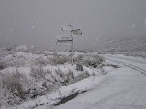
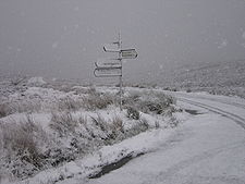
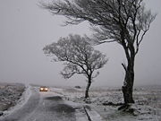
In winter it is often dangerous or impassable due to snow and ice as it is not treated by the Local Authority.
The highest point on the road is at the Sally Gap where it crosses the Military Road (R115
R115 road
The R115 road is a regional road in counties Dublin and Wicklow in Ireland. It follows the Military Road for its entire length. The R115 is long; the full length of the Military Road is...
), 503m (1,650 ft).
The road passes through some spectacular scenery, including the deep corrie
Cirque
Cirque may refer to:* Cirque, a geological formation* Makhtesh, an erosional landform found in the Negev desert of Israel and Sinai of Egypt*Cirque , an album by Biosphere* Cirque Corporation, a company that makes touchpads...
lake Lough Tay
Lough Tay
Lough Tay is a small but scenic lake set in the Wicklow Mountains in County Wicklow, Ireland. It lies between the mountains of Djouce and Luggala, and is most easily viewed from above, from the R759 or the Wicklow Way as it descends past the J. B. Malone memorial...
below Luggala
Luggala
Luggala , also called Fancy Mountain , is a mountain in the Wicklow Mountains, Ireland. Its cliffs are situated above a lake, Lough Tay, and are a popular location for rock climbing.Luggala is about southwest of Dublin.- Luggala Estate :...
in the eastern hills, the moorlands of the Sally Gap plateau and the valley of the River Liffey
River Liffey
The Liffey is a river in Ireland, which flows through the centre of Dublin. Its major tributaries include the River Dodder, the River Poddle and the River Camac. The river supplies much of Dublin's water, and a range of recreational opportunities.-Name:The river was previously named An Ruirthech,...
for its descent from Sally Gap down to the N81 in west Wicklow.
The road is 27 km (16.8 mi) long.
See also
- Roads in IrelandRoads in IrelandThe island of Ireland, comprising Northern Ireland and the Republic of Ireland, has an extensive network of tens of thousands of kilometres of public roads, usually surfaced. These roads have been developed and modernised over centuries, from trackways suitable only for walkers and horses, to...
- National primary roadNational primary roadA national primary road is a road classification in the Republic of Ireland. National primary roads form the major routes between the major urban centres. There are over 2,700km of national primary roads. This category of road has the prefix "N" followed by one or two digits...
- National secondary roadNational secondary roadA national secondary road is a category of road in Ireland. These roads form an important part of the national route network, but are secondary to the main arterial routes which are classified as national primary roads. National secondary roads are designated with route numbers higher than those...
- Rathfarnham and the Military Road
- Ireland's first ski rescue