
Townland
Encyclopedia

Ireland
Ireland is an island to the northwest of continental Europe. It is the third-largest island in Europe and the twentieth-largest island on Earth...
. The townland system is of Gaelic
Gaelic Ireland
Gaelic Ireland is the name given to the period when a Gaelic political order existed in Ireland. The order continued to exist after the arrival of the Anglo-Normans until about 1607 AD...
origin—most townlands are believed to pre-date the Norman invasion
Norman Invasion of Ireland
The Norman invasion of Ireland was a two-stage process, which began on 1 May 1169 when a force of loosely associated Norman knights landed near Bannow, County Wexford...
and most have names derived from the Irish language
Irish language
Irish , also known as Irish Gaelic, is a Goidelic language of the Indo-European language family, originating in Ireland and historically spoken by the Irish people. Irish is now spoken as a first language by a minority of Irish people, as well as being a second language of a larger proportion of...
. However, some townland names and boundaries derive from Norman
Hiberno-Norman
The Hiberno-Normans are those Norman lords who settled in Ireland who admitted little if any real fealty to the Anglo-Norman settlers in England, and who soon began to interact and intermarry with the Gaelic nobility of Ireland. The term embraces both their origins as a distinct community with...
manor
Manorialism
Manorialism, an essential element of feudal society, was the organizing principle of rural economy that originated in the villa system of the Late Roman Empire, was widely practiced in medieval western and parts of central Europe, and was slowly replaced by the advent of a money-based market...
s, plantation
Plantations of Ireland
Plantations in 16th and 17th century Ireland were the confiscation of land by the English crown and the colonisation of this land with settlers from England and the Scottish Lowlands....
divisions, or later creations of the Ordnance Survey
Ordnance Survey Ireland
Ordnance Survey Ireland is the national mapping agency of the Republic of Ireland and, together with the Ordnance Survey of Northern Ireland , succeeded, after 1922, the Irish operations of the United Kingdom Ordnance Survey. It is part of the Public service of the Republic of Ireland...
. There are currently 61,402 named townlands in Ireland, covering the whole island. The term was at one time also used in Scotland
Scotland
Scotland is a country that is part of the United Kingdom. Occupying the northern third of the island of Great Britain, it shares a border with England to the south and is bounded by the North Sea to the east, the Atlantic Ocean to the north and west, and the North Channel and Irish Sea to the...
.
Etymology
In Gaelic times, the Irish name for what we now know as townlands would have changed as one travelled through the island. The EnglishEnglish language
English is a West Germanic language that arose in the Anglo-Saxon kingdoms of England and spread into what was to become south-east Scotland under the influence of the Anglian medieval kingdom of Northumbria...
term townland was later adopted as a standard name to replace the various local forms.
One of the commonest names used in Irish was baile (plural bailte); a general term for "homestead" or "settlement". The modern official term for townland in Irish is baile fearainn (plural bailte fearainn). The term fearann means "land, territory, quarter" — from a Proto-Indo-European root *wer- which is also related to the English word ware, a valuable commodity. Baile is usually anglicised
Anglicisation
Anglicisation, or anglicization , is the process of converting verbal or written elements of any other language into a form that is more comprehensible to an English speaker, or, more generally, of altering something such that it becomes English in form or character.The term most often refers to...
as bally (for example in Ballymena
Ballymena
Ballymena is a large town in County Antrim, Northern Ireland and the seat of Ballymena Borough Council. Ballymena had a population of 28,717 people in the 2001 Census....
) and Fearann as farran (for example in Farranfore
Farranfore
Farranfore is a village in County Kerry, Ireland. It lies on the N22 road approximately midway between Tralee and Killarney and on the railway line connecting those two towns....
). Although not its original meaning, baile was later adopted as the Irish term for "town".
The Scottish Gaelic form is baile (plural bailtean), while the Manx
Manx language
Manx , also known as Manx Gaelic, and as the Manks language, is a Goidelic language of the Indo-European language family, historically spoken by the Manx people. Only a small minority of the Island's population is fluent in the language, but a larger minority has some knowledge of it...
form is balley (plural baljyn).
Size
In Ireland, a townland is the smallest officially-defined geographical division of land, smaller than a parishParish
A parish is a territorial unit historically under the pastoral care and clerical jurisdiction of one parish priest, who might be assisted in his pastoral duties by a curate or curates - also priests but not the parish priest - from a more or less central parish church with its associated organization...
, barony
Barony (Ireland)
In Ireland, a barony is a historical subdivision of a county. They were created, like the counties, in the centuries after the Norman invasion, and were analogous to the hundreds into which the counties of England were divided. In early use they were also called cantreds...
and county
County
A county is a jurisdiction of local government in certain modern nations. Historically in mainland Europe, the original French term, comté, and its equivalents in other languages denoted a jurisdiction under the sovereignty of a count A county is a jurisdiction of local government in certain...
. Townlands vary in size from the smallest, of less than an acre (Old Church Yard, Carrickmore, parish of Termonmagurk, County Tyrone
County Tyrone
Historically Tyrone stretched as far north as Lough Foyle, and comprised part of modern day County Londonderry east of the River Foyle. The majority of County Londonderry was carved out of Tyrone between 1610-1620 when that land went to the Guilds of London to set up profit making schemes based on...
), up to 7012 acres (28.4 km²) or 28.3 km² (Sheskin, parish of Kilcommon, County Mayo
County Mayo
County Mayo is a county in Ireland. It is located in the West Region and is also part of the province of Connacht. It is named after the village of Mayo, which is now generally known as Mayo Abbey. Mayo County Council is the local authority for the county. The population of the county is 130,552...
). Typically 200 to 400 acres (1.6 km²) is a reasonable average.
The reason for this great variation in size is because townlands were based on the fertility of the land; hence an area of very fertile land will have smaller townlands than an area with little fertile land. It seems that many moorland
Moorland
Moorland or moor is a type of habitat, in the temperate grasslands, savannas, and shrublands biome, found in upland areas, characterised by low-growing vegetation on acidic soils and heavy fog...
areas were not divided into townlands until fairly recently. These areas were "formerly shared as a common summer pasturage
Common land
Common land is land owned collectively or by one person, but over which other people have certain traditional rights, such as to allow their livestock to graze upon it, to collect firewood, or to cut turf for fuel...
by the people of a whole parish or barony".
Origin of townland system
The townland system is of GaelicGaelic Ireland
Gaelic Ireland is the name given to the period when a Gaelic political order existed in Ireland. The order continued to exist after the arrival of the Anglo-Normans until about 1607 AD...
origin—most townlands are believed to pre-date the Norman invasion
Norman Invasion of Ireland
The Norman invasion of Ireland was a two-stage process, which began on 1 May 1169 when a force of loosely associated Norman knights landed near Bannow, County Wexford...
(which began in 1169) and most have names that are anglicised
Anglicisation
Anglicisation, or anglicization , is the process of converting verbal or written elements of any other language into a form that is more comprehensible to an English speaker, or, more generally, of altering something such that it becomes English in form or character.The term most often refers to...
forms of earlier Irish
Irish language
Irish , also known as Irish Gaelic, is a Goidelic language of the Indo-European language family, originating in Ireland and historically spoken by the Irish people. Irish is now spoken as a first language by a minority of Irish people, as well as being a second language of a larger proportion of...
names. However, the names and boundaries of some townlands derive from Hiberno-Norman
Hiberno-Norman
The Hiberno-Normans are those Norman lords who settled in Ireland who admitted little if any real fealty to the Anglo-Norman settlers in England, and who soon began to interact and intermarry with the Gaelic nobility of Ireland. The term embraces both their origins as a distinct community with...
manor
Manorialism
Manorialism, an essential element of feudal society, was the organizing principle of rural economy that originated in the villa system of the Late Roman Empire, was widely practiced in medieval western and parts of central Europe, and was slowly replaced by the advent of a money-based market...
s, Plantation
Plantations of Ireland
Plantations in 16th and 17th century Ireland were the confiscation of land by the English crown and the colonisation of this land with settlers from England and the Scottish Lowlands....
divisions, or later creations of the Ordnance Survey
Ordnance Survey Ireland
Ordnance Survey Ireland is the national mapping agency of the Republic of Ireland and, together with the Ordnance Survey of Northern Ireland , succeeded, after 1922, the Irish operations of the United Kingdom Ordnance Survey. It is part of the Public service of the Republic of Ireland...
.
The first official evidence of their existence can be found in church records from before the 12th century. A townland or baile was originally the holding of an extended family.
The term townland is a standardised form, often replacing earlier local terms such as tate
Tathe
A tathe or tate is a unit of area which was used in Fermanagh and Monaghan, equivalent to 60 Irish acres.Four tathes make a quarter of land, four quarters make a ballibetagh and, in Fermanagh, seven ballibetaghs make a barony, of which there were seven. However, the measure of a ballibetagh is far...
(in Fermanagh and Monaghan
County Monaghan
County Monaghan is a county in Ireland. It is part of the Border Region and is also located in the province of Ulster. It is named after the town of Monaghan. Monaghan County Council is the local authority for the county...
), cartron (in Connacht
Connacht
Connacht , formerly anglicised as Connaught, is one of the Provinces of Ireland situated in the west of Ireland. In Ancient Ireland, it was one of the fifths ruled by a "king of over-kings" . Following the Norman invasion of Ireland, the ancient kingdoms were shired into a number of counties for...
) or ploughland. These terms represent a variety of native land divisions, varying in name from one part of the country to another, and forming a hierarchy of sizes.
The nineteenth-century surveyor Thomas Larcom
Thomas Larcom
Major-General Sir Thomas Aiskew Larcom, 1st Baronet PC FRS was a leading official in the early Irish Ordnance Survey that started in 1824...
, who was the first Director of the Irish Ordnance Survey, summarised the hierarchy as follows:
10 acres - 1 Gneeve; 2 Gneeves - 1 Sessiagh; 3 Sessiaghs - 1 Tate or Ballyboe; 2 Ballyboes - 1 Ploughland, Seisreagh or Carrow; 4 Ploughlands - 1 Ballybetagh, or Townland; 30 Ballybetaghs - Triocha CéadTrícha cétA Trícha cét or triocha cét was a a territorial unit ... to the eleventh and twelfth centuries [1] in medieval Ireland. It was succeeded by the cantred.Paul MacCotter describes it as:...
or BaronyBarony (Ireland)In Ireland, a barony is a historical subdivision of a county. They were created, like the counties, in the centuries after the Norman invasion, and were analogous to the hundreds into which the counties of England were divided. In early use they were also called cantreds...
.
However, as noted previously, land was measured in terms of its economic potential. Therefore the size of an "acre" in this system could vary greatly depending on the quality of the land.
Under English rule
Townlands were first named and their boundaries defined under the English legal system during the process of plantationPlantations of Ireland
Plantations in 16th and 17th century Ireland were the confiscation of land by the English crown and the colonisation of this land with settlers from England and the Scottish Lowlands....
. The unit from the hierarchy of land divisions that was chosen to represent a "townland", however, might vary from county to county; in Fermanagh and Monaghan, the tate was chosen, resulting in relatively small townlands, while in other areas, larger units such as ploughlands were chosen, resulting in larger townland units.
In many areas of Norman settlement, townland boundaries tend to follow field
Open field system
The open field system was the prevalent agricultural system in much of Europe from the Middle Ages to as recently as the 20th century in some places, particularly Russia and Iran. Under this system, each manor or village had several very large fields, farmed in strips by individual families...
or individual property boundaries and may reflect the holdings of monasteries or churches or the boundaries of commonage
Common land
Common land is land owned collectively or by one person, but over which other people have certain traditional rights, such as to allow their livestock to graze upon it, to collect firewood, or to cut turf for fuel...
. In these areas, townlands often have apparently irregular boundaries and are of small size. In contrast, townlands in areas of traditional Gaelic settlement tend to be larger in area and usually have apparently regular boundaries determined by streams, rivers or roads.
Irish Ordnance Survey and standardisation
During the middle decades of the 19th century, an extensive series of maps of Ireland were created by the Irish division of the Ordnance Survey for taxation purposes, which documented and standardised the boundaries of the more than 60,000 townlands in Ireland. This process often involved dividing or amalgamating existing townlands, and defining townland boundaries in areas such as mountain or bog land that had previously been outside the townland system.Current use
Townlands form the building blocks for higher-level administrative units such as parishes and District Electoral DivisionDistrict Electoral Division
A district electoral division is a former name given to a low-level territorial division in Ireland. In 1994, both district electoral divisions and wards were renamed as electoral divisions...
s (in the Republic of Ireland
Republic of Ireland
Ireland , described as the Republic of Ireland , is a sovereign state in Europe occupying approximately five-sixths of the island of the same name. Its capital is Dublin. Ireland, which had a population of 4.58 million in 2011, is a constitutional republic governed as a parliamentary democracy,...
) or wards (in Northern Ireland
Northern Ireland
Northern Ireland is one of the four countries of the United Kingdom. Situated in the north-east of the island of Ireland, it shares a border with the Republic of Ireland to the south and west...
). Before 1972, townlands were included on all postal addresses throughout the island. However, in 1972 Royal Mail
Royal Mail
Royal Mail is the government-owned postal service in the United Kingdom. Royal Mail Holdings plc owns Royal Mail Group Limited, which in turn operates the brands Royal Mail and Parcelforce Worldwide...
decided that the townland element of the address was obsolete in Northern Ireland. Townland names were not banned but were deemed "superflouous information" and people were asked not to include them on addresses. They would be replaced by house numbers, road names, and postcodes. In response, the "Townlands Campaign" emerged to protest against the changes. It was described as a "ground-level community effort". Taking place in the midst of "The Troubles
The Troubles
The Troubles was a period of ethno-political conflict in Northern Ireland which spilled over at various times into England, the Republic of Ireland, and mainland Europe. The duration of the Troubles is conventionally dated from the late 1960s and considered by many to have ended with the Belfast...
", the campaign was a rare example of unity between Catholics
Irish Catholic
Irish Catholic is a term used to describe people who are both Roman Catholic and Irish .Note: the term is not used to describe a variant of Catholicism. More particularly, it is not a separate creed or sect in the sense that "Anglo-Catholic", "Old Catholic", "Eastern Orthodox Catholic" might be...
and Protestants
Protestantism
Protestantism is one of the three major groupings within Christianity. It is a movement that began in Germany in the early 16th century as a reaction against medieval Roman Catholic doctrines and practices, especially in regards to salvation, justification, and ecclesiology.The doctrines of the...
, nationalists
Irish nationalism
Irish nationalism manifests itself in political and social movements and in sentiment inspired by a love for Irish culture, language and history, and as a sense of pride in Ireland and in the Irish people...
and unionists
Unionism in Ireland
Unionism in Ireland is an ideology that favours the continuation of some form of political union between the islands of Ireland and Great Britain...
. Townlands and their names "seem to have been considered as a shared resource and heritage". Those involved in the campaign argued that, in many areas, people still strongly identified with their townlands and that this gave them a sense of belonging. Royal Mail's changes were seen as a severing of this link.
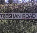
At the time, the county councils were the government bodies responsible for validating such a change. However, as local government itself was undergoing changes, Royal Mail's decision was "allowed ... to become law almost by default". County Fermanagh
County Fermanagh
Fermanagh District Council is the only one of the 26 district councils in Northern Ireland that contains all of the county it is named after. The district council also contains a small section of County Tyrone in the Dromore and Kilskeery road areas....
is the only Northern Ireland county that managed to resist the scheme completely. Nevertheless, most road signs in Northern Ireland continue to show townland names (see picture on the right). In 2001 the Northern Ireland Assembly
Northern Ireland Assembly
The Northern Ireland Assembly is the devolved legislature of Northern Ireland. It has power to legislate in a wide range of areas that are not explicitly reserved to the Parliament of the United Kingdom, and to appoint the Northern Ireland Executive...
passed a motion requesting government departments to make use of townland addresses in correspondence and publications.
In the Republic of Ireland, townlands continued to be used on addresses. However, in 2005 the Department of Communications, Energy and Natural Resources announced that the postcode system is to be introduced (see Republic of Ireland postal addresses).
A useful source of information on townlands (with an emphasis on the northern parts of Ireland) is the Federation for Ulster Local Studies. Its publications include Every Stony Acre Has a Name: Celebration of the Townland in Ulster by Tony Canavan, and Townlands in Ulster: Local History Studies, edited by W.H. Crawford & R.H. Foy.
Scotland
In Scotland, townland boundaries were generally disregarded and lost during 19th century agricultural improvements. Townlands were called also fermlands and many names remain identifiable in farmstead names which include the word MainsMains (Scotland)
Mains in Scotland normally refers to the main buildings of a farm. This may include a farmhouse, farm buildings such as a byre and dairy, and workers' cottages...
, and "Bal-" (Baile) in placenames, such as Balerno
Balerno
Balerno is a suburb of Edinburgh, Scotland situated 12 kilometres south west of the city centre, next to Juniper Green and Currie. Administratively, Balerno falls within the jurisdiction of the City of Edinburgh Council.- History :...
or Balmoral
Balmoral
- Australia :* Balmoral, New South Wales, a locality of Sydney* Balmoral, New South Wales * Balmoral, New South Wales * Balmoral, Queensland* Balmoral, Victoria* Balmoral, Western Australia- Canada :...
.
Townlands in Scotland were often in contradistinction to kirktouns (Clachan), which were settlements with a church, sometimes of ecclesiastical origin.
See also Township (Scotland)
Township (Scotland)
In Scotland a crofting township is a group of agricultural smallholdings holding in common a substantial tract of unimproved upland grazing...
for the crofting context.
Isle of Man
There may be similarities between the notion of townlands in Ireland and the traditional land divisions of treens (c.f. the Irish word trian, a third part) in the Isle of ManIsle of Man
The Isle of Man , otherwise known simply as Mann , is a self-governing British Crown Dependency, located in the Irish Sea between the islands of Great Britain and Ireland, within the British Isles. The head of state is Queen Elizabeth II, who holds the title of Lord of Mann. The Lord of Mann is...
. Treens are subdivided into smaller units called quarterlands.
External links
- Searchable database of townlands in Ireland derived from the Index to the 1851 Census of Ireland
- http://ims0.osiemaps.ie/website/publicviewer/main.aspx#V1,600000,750000,0Viewer from Ordnance Survey IrelandOrdnance Survey IrelandOrdnance Survey Ireland is the national mapping agency of the Republic of Ireland and, together with the Ordnance Survey of Northern Ireland , succeeded, after 1922, the Irish operations of the United Kingdom Ordnance Survey. It is part of the Public service of the Republic of Ireland...
showing townland boundaries on 1st Edition Ordnance Survey Maps] - Set of Excel spreadsheets, listing all townlands in the Republic of Ireland and the 1898 District Electoral Division they belong to.
- Database of townland names in Northern Ireland, searchable using both maps and lists, with information about placename origins
- Placenames Database of Ireland, listing English and Irish versions of townland, parish and barony names
- Lists of townlands by parish in Ulster
- Mayo County Library list of townlands by parish with maps and other details
- Searchable Database of Townlands in Co Kildare
- Irish Placenames Article