

R115 road
Encyclopedia
The R115 road is a regional road
in counties Dublin and Wicklow
in Ireland
. It follows the Military Road for its entire length. The R115 is 40 km (24.9 mi) long; the full length of the Military Road (Rathfarnham
to Aghavannagh
) is 55 km (34.2 mi). The Military Road starts in Rathfarnham.
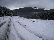
Image:Sally_Gap_R115-R759_crossroads.jpg|380px|thumb|left|Military Road joins the R759
at Sally Gap
desc none
poly 1776 240 1764 332 1766 338 2030 322 2066 264 2018 198 Roundwood
poly 1444 382 1402 428 1436 482 1694 474 1694 358 Blessington
poly 1758 498 1906 518 1920 570 1906 622 1748 608 Glencree
poly 1766 636 1952 644 1968 692 1956 746 1762 736 Dublin
 The Military Road (still in use mainly for tourist traffic) runs through the Wicklow Mountains
, running North/South across the spine of the hills. Construction of the road started on 12 August 1800 and it was completed in October 1809. It was built in the wake of the 1798 rebellion
to open up the Wicklow Mountains to the British Army
to assist them in putting down the insurgents who were hiding there following the Irish Rebellion of 1798
. Rathfarnham itself was the scene of some skirmishes in the early days of the Rising.
The Military Road was one of the first purpose-built roads in Ireland. Five barracks were built along the way at Leitrim, Glencree
, Laragh, Glenmalure
and Aghavannagh. The engineer in charge was Alexander Taylor (born in 1746), who was responsible for many other roads in the country, including some "turnpike roads
", which are toll roads
.
, outside the Yellow House pub and continues to the Ballyboden roundabout, where it intersects with the R113
; it then follows the Edmondstown
Road for 100 metres where it meets the R116
. At this point the route takes the Scholarstown Road and turns left onto Stocking Lane where it rises through the Dublin Mountains (past the Hell Fire Club), followed by a descent into Glencree at the head of the valley of the Glencree river, with a spur down that valley to Enniskerry
, before rising again to the 53.137979°N 6.311688°W Sally Gap Crossroads, where it intersects with the R759
, close to the highest point on the road which is 510m (1,670ft). From there it continues to a point east of Mullaghcleevaun Mountain (850m) before descending to the village of Laragh
, near Glendalough
.
The R115 terminates at Laragh, at a junction with the R755
and the 'Wicklow Gap' road, the R756
. The Military Road continues south (see thumbnail) past Glenmalure to Aghavannagh in south County Wicklow
, but is designated as a local road south of Laragh.
A well known stretch is The Featherbeds, the section below Kippure Mountain
. The total distance is 34 Irish miles, of which the spur to Enniskerry
is 5 Irish miles.
For many years, the road was used as the Sally Gap special stage
in the Circuit of Ireland
car rally.
Regional road
A regional road in Ireland is a class of road not forming a major route , but nevertheless forming a link in the national route network. There are over 11,600 kilometres of regional roads. Regional roads are numbered with three digit route numbers, prefixed by "R" A regional road in Ireland is a...
in counties Dublin and Wicklow
Wicklow
Wicklow) is the county town of County Wicklow in Ireland. Located south of Dublin on the east coast of the island, it has a population of 10,070 according to the 2006 census. The town is situated to the east of the N11 route between Dublin and Wexford. Wicklow is also connected to the rail...
in Ireland
Republic of Ireland
Ireland , described as the Republic of Ireland , is a sovereign state in Europe occupying approximately five-sixths of the island of the same name. Its capital is Dublin. Ireland, which had a population of 4.58 million in 2011, is a constitutional republic governed as a parliamentary democracy,...
. It follows the Military Road for its entire length. The R115 is 40 km (24.9 mi) long; the full length of the Military Road (Rathfarnham
Rathfarnham
Rathfarnham or Rathfarnam is a Southside suburb of Dublin, Ireland. It is south of Terenure, east of Templeogue, and is in the postal districts of Dublin 14 and 16. It is within the administrative areas of both Dun Laoghaire-Rathdown and South Dublin County Councils.The area of Rathfarnham...
to Aghavannagh
Aghavannagh
Aghavannagh is a small village and townland in south County Wicklow, Ireland in the barony of Ballinacor South. It is located on the Military Road originally constructed between 1804 and 1809, in the wake of the 1798 rebellion...
) is 55 km (34.2 mi). The Military Road starts in Rathfarnham.
R759 road
The R759 road is a regional road in Ireland that runs south-east to north-west through the Sally Gap in the Wicklow Mountains from the R755 near Roundwood in East Wicklow to the N81 in West Wicklow....
at Sally Gap
desc none
poly 1776 240 1764 332 1766 338 2030 322 2066 264 2018 198 Roundwood
Roundwood
Roundwood, historically known as Tochar , is a village in County Wicklow, Ireland. It was listed as having a population of 589 in the census of 2006....
poly 1444 382 1402 428 1436 482 1694 474 1694 358 Blessington
Blessington
Blessington, historically known as Ballycomeen , is a town in County Wicklow, Ireland. It is located on the N81 road, which connects Dublin to Tullow.- History :...
poly 1758 498 1906 518 1920 570 1906 622 1748 608 Glencree
Glencree
Glencree is a valley in the Wicklow Mountains in eastern Ireland. It is the second closest valley in the mountains to Dublin city, the first being Glencullen. The river Dargle flows down the valley, which rises to a height of abut 400 metres...
poly 1766 636 1952 644 1968 692 1956 746 1762 736 Dublin
Wicklow Mountains
The Wicklow Mountains form the largest continuous upland area in Ireland. They occupy the whole centre of County Wicklow and stretch outside its borders into Counties Carlow, Wexford and Dublin. Where the mountains extend into County Dublin, they are known locally as the Dublin Mountains...
, running North/South across the spine of the hills. Construction of the road started on 12 August 1800 and it was completed in October 1809. It was built in the wake of the 1798 rebellion
Irish Rebellion of 1798
The Irish Rebellion of 1798 , also known as the United Irishmen Rebellion , was an uprising in 1798, lasting several months, against British rule in Ireland...
to open up the Wicklow Mountains to the British Army
British Army
The British Army is the land warfare branch of Her Majesty's Armed Forces in the United Kingdom. It came into being with the unification of the Kingdom of England and Scotland into the Kingdom of Great Britain in 1707. The new British Army incorporated Regiments that had already existed in England...
to assist them in putting down the insurgents who were hiding there following the Irish Rebellion of 1798
Irish Rebellion of 1798
The Irish Rebellion of 1798 , also known as the United Irishmen Rebellion , was an uprising in 1798, lasting several months, against British rule in Ireland...
. Rathfarnham itself was the scene of some skirmishes in the early days of the Rising.
The Military Road was one of the first purpose-built roads in Ireland. Five barracks were built along the way at Leitrim, Glencree
Glencree
Glencree is a valley in the Wicklow Mountains in eastern Ireland. It is the second closest valley in the mountains to Dublin city, the first being Glencullen. The river Dargle flows down the valley, which rises to a height of abut 400 metres...
, Laragh, Glenmalure
Glenmalure
Glenmalure is a valley in the Wicklow Mountains in eastern Ireland. It is a u-shaped glacial valley, with only one road leading into it, which connects to the 'Military Road' at the mouth of the valley....
and Aghavannagh. The engineer in charge was Alexander Taylor (born in 1746), who was responsible for many other roads in the country, including some "turnpike roads
Toll road
A toll road is a privately or publicly built road for which a driver pays a toll for use. Structures for which tolls are charged include toll bridges and toll tunnels. Non-toll roads are financed using other sources of revenue, most typically fuel tax or general tax funds...
", which are toll roads
Toll road
A toll road is a privately or publicly built road for which a driver pays a toll for use. Structures for which tolls are charged include toll bridges and toll tunnels. Non-toll roads are financed using other sources of revenue, most typically fuel tax or general tax funds...
.
Route
The official definition of the R115 from the Roads Act 1993 (Classification of Regional Roads) Order 2006 reads:- R115: Rathfarnham, County Dublin - Laragh, County Wicklow
- Between its junction with R114 at Butterfield Avenue Rathfarnham in the county of South Dublin and its junction with R755 at Laragh in the county of Wicklow via Grange Road, Willbrook Road, Ballyboden Road, Scholarstown Road, Stocking Lane and Military Road in the county of South Dublin: Glencree, Liffey Head Bridge, Sally Gap and Drummin in the county of Wicklow.
Description
The R115 / Military Road starts in Rathfarnham, County DublinCounty Dublin
County Dublin is a county in Ireland. It is part of the Dublin Region and is also located in the province of Leinster. It is named after the city of Dublin which is the capital of Ireland. County Dublin was one of the first of the parts of Ireland to be shired by King John of England following the...
, outside the Yellow House pub and continues to the Ballyboden roundabout, where it intersects with the R113
R113 road
The R113 road is a regional road in Ireland. Located in the east of Ireland at Dublin, it forms a semi-orbital route around the south of the city. As of 2007, clockwise, it starts at the N31 at Temple Hill in Blackrock and ends at a junction with the N4 at Palmerstown.The road is one of the...
; it then follows the Edmondstown
Edmondstown
Edmondstown is an area in South Dublin. It situated on the R116 regional road, south of Ballyboden and north of Rockbrook, in the valley of the Oewdoher River. Edmondstown National School is a senior primary school which serves the local area. The school principal is Mr.Damien Burke.The school...
Road for 100 metres where it meets the R116
R116 road
The R116 road is a regional road in Ireland which runs east-west from the N11 at Loughlinstown to the R115 in Ballyboden. It runs through the South of County Dublin for its entire length...
. At this point the route takes the Scholarstown Road and turns left onto Stocking Lane where it rises through the Dublin Mountains (past the Hell Fire Club), followed by a descent into Glencree at the head of the valley of the Glencree river, with a spur down that valley to Enniskerry
Enniskerry
Enniskerry is a village in County Wicklow, Ireland. It had a population of 2,672 at the 2006 census.- Location :...
, before rising again to the 53.137979°N 6.311688°W Sally Gap Crossroads, where it intersects with the R759
R759 road
The R759 road is a regional road in Ireland that runs south-east to north-west through the Sally Gap in the Wicklow Mountains from the R755 near Roundwood in East Wicklow to the N81 in West Wicklow....
, close to the highest point on the road which is 510m (1,670ft). From there it continues to a point east of Mullaghcleevaun Mountain (850m) before descending to the village of Laragh
Laragh, County Wicklow
Laragh is a small picturesque village in County Wicklow, Ireland. It lies at the junction of three roads through the Wicklow Mountains and is primarily known for its proximity to the monastic settlement of Glendalough...
, near Glendalough
Glendalough
Glendalough or Glendaloch is a glacial valley in County Wicklow, Ireland. It is renowned for its Early Medieval monastic settlement founded in the 6th century by St Kevin, a hermit priest, and partly destroyed in 1398 by English troops....
.
The R115 terminates at Laragh, at a junction with the R755
R755 road
The R755 road is a regional road in Ireland. It runs for its entire length in County Wicklow. From the village of Kilmacanogue on the N11 national primary road it goes north/south for to the town of Rathdrum.-Route:...
and the 'Wicklow Gap' road, the R756
R756 road
The R756 road is a regional road in Ireland running west-east from Dunlavin to Laragh. Its entire length is within County Wicklow crossing east/west through the Wicklow Gap ....
. The Military Road continues south (see thumbnail) past Glenmalure to Aghavannagh in south County Wicklow
County Wicklow
County Wicklow is a county in Ireland. It is part of the Mid-East Region and is also located in the province of Leinster. It is named after the town of Wicklow, which derives from the Old Norse name Víkingalág or Wykynlo. Wicklow County Council is the local authority for the county...
, but is designated as a local road south of Laragh.
A well known stretch is The Featherbeds, the section below Kippure Mountain
Kippure
Kippure is a granite mountain that straddles the county boundaries of South Dublin and Wicklow. It is popular for hill walking and outdoor leisure activity owing to its proximity to Dublin city, with its fine views over Dublin Bay towards Howth Head. It has convenient access and easy terrain...
. The total distance is 34 Irish miles, of which the spur to Enniskerry
Enniskerry
Enniskerry is a village in County Wicklow, Ireland. It had a population of 2,672 at the 2006 census.- Location :...
is 5 Irish miles.
For many years, the road was used as the Sally Gap special stage
Special stage (rallying)
Special stages are the competitive sections of a stage rally event where the goal is to cover a stretch of closed road in the shortest time. On a special stage cars are set off individually at set intervals to reduce the chances of being impeded by other competitors. Each special stage is a...
in the Circuit of Ireland
Circuit of Ireland Rally
The Circuit of Ireland International Rally is an annual automobile rally, which was first held in 1931 making it the second oldest rally in the world. The most recent event was held in 2010....
car rally.
See also
- Roads in IrelandRoads in IrelandThe island of Ireland, comprising Northern Ireland and the Republic of Ireland, has an extensive network of tens of thousands of kilometres of public roads, usually surfaced. These roads have been developed and modernised over centuries, from trackways suitable only for walkers and horses, to...
- Motorways in Ireland
- National primary roadNational primary roadA national primary road is a road classification in the Republic of Ireland. National primary roads form the major routes between the major urban centres. There are over 2,700km of national primary roads. This category of road has the prefix "N" followed by one or two digits...
- National secondary roadNational secondary roadA national secondary road is a category of road in Ireland. These roads form an important part of the national route network, but are secondary to the main arterial routes which are classified as national primary roads. National secondary roads are designated with route numbers higher than those...
- Rathfarnham and the Military Road
- Ireland's first ski rescue
External links
Further reading
- "The Wicklow Military Road - history and topography" (2007) by Michael Fewer; ISBN 13:978 1 901658 66 8.