

Qanat
Encyclopedia

Water management
Water management is the activity of planning, developing, distributing and managing the optimum use of water resources. In an ideal world. water management planning has regard to all the competing demands for water and seeks to allocate water on an equitable basis to satisfy all uses and demands...
system used to provide a reliable supply of water for human settlements and irrigation
Irrigation
Irrigation may be defined as the science of artificial application of water to the land or soil. It is used to assist in the growing of agricultural crops, maintenance of landscapes, and revegetation of disturbed soils in dry areas and during periods of inadequate rainfall...
in hot, arid
Arid
A region is said to be arid when it is characterized by a severe lack of available water, to the extent of hindering or even preventing the growth and development of plant and animal life...
and semi-arid climates. Qanats are also called kārīz (or kārēz from ) (Iran, Afghanistan, Pakistan and Central Asia, derived from ), kahan (from ), khettara (Morocco); galería (Spain); falaj (United Arab Emirates and Oman); Kahn (Baloch) or foggara/fughara (North Africa). Alternative terms for qanats in Asia and North Africa are kakuriz, chin-avulz, and mayun. Common variants of qanat in English include kanat, khanat, kunut, kona, konait, ghanat, ghundat.
The qanat technology
Technology
Technology is the making, usage, and knowledge of tools, machines, techniques, crafts, systems or methods of organization in order to solve a problem or perform a specific function. It can also refer to the collection of such tools, machinery, and procedures. The word technology comes ;...
is known to have developed on the Iran
Iran
Iran , officially the Islamic Republic of Iran , is a country in Southern and Western Asia. The name "Iran" has been in use natively since the Sassanian era and came into use internationally in 1935, before which the country was known to the Western world as Persia...
ian plateau and possibly also in the Arabian peninsula
Arabian Peninsula
The Arabian Peninsula is a land mass situated north-east of Africa. Also known as Arabia or the Arabian subcontinent, it is the world's largest peninsula and covers 3,237,500 km2...
sometime in the early 1st millennium BC spread from there slowly west- and eastward.
The value of a qanat is directly related to the quality, volume and regularity of the water flow. Much of the population of Iran and other arid countries in Asia and North Africa historically depended upon the water from qanats; the areas of population corresponded closely to the areas where qanats are possible. Although a qanat was expensive to construct, its long-term value to the community, and therefore to the group who invested in building and maintaining it, was substantial.
Technical features
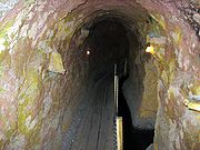
Qanats are constructed as a series of well-likeWater well
A water well is an excavation or structure created in the ground by digging, driving, boring or drilling to access groundwater in underground aquifers. The well water is drawn by an electric submersible pump, a trash pump, a vertical turbine pump, a handpump or a mechanical pump...
vertical shaft
Shaft mining
Shaft mining or shaft sinking refers to the method of excavating a vertical or near-vertical tunnel from the top down, where there is initially no access to the bottom....
s, connected by gently sloping tunnel
Tunnel
A tunnel is an underground passageway, completely enclosed except for openings for egress, commonly at each end.A tunnel may be for foot or vehicular road traffic, for rail traffic, or for a canal. Some tunnels are aqueducts to supply water for consumption or for hydroelectric stations or are sewers...
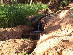
s. Qanats tap into subterranean water in a manner that efficiently delivers large quantities of water to the surface without need for pumping. The water drains relying on gravity, with the destination lower than the source, which is typically an upland aquifer
Aquifer
An aquifer is a wet underground layer of water-bearing permeable rock or unconsolidated materials from which groundwater can be usefully extracted using a water well. The study of water flow in aquifers and the characterization of aquifers is called hydrogeology...
. Qanats allow water to be transported over long distances in hot dry climates without losing a large proportion of the water to seepage and evaporation
Evaporation
Evaporation is a type of vaporization of a liquid that occurs only on the surface of a liquid. The other type of vaporization is boiling, which, instead, occurs on the entire mass of the liquid....
.
It is very common in the construction of a qanat for the water source to be found below ground at the foot of a range of foothills of mountains, where the water table is closest to the surface. From this point, the slope of the qanat is maintained closer to level than the surface above, until the water finally flows out of the qanat above ground. To reach an aquifer, qanats must often extend for long distances.
Qanats are sometimes split into an underground distribution network of smaller canals called kariz
Kariz
Kariz refers to water supply - kareez In its early beginnings, Samarkand occupied part of Mount Afrasiab , which rises to the north of today’s Samarkand. As the city grew, it expanded its borders, and by the 9th century it occupied the entire hill...
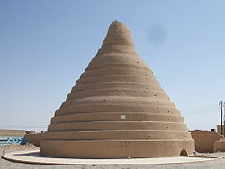
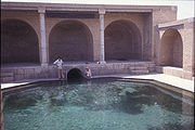
. Like qanats, these smaller canals were below ground to avoid contamination. In some cases water from a qanat is stored in a reservoir, typically storing night flow for daytime use. An Ab Anbar
Ab Anbar
An āb anbār is a traditional reservoir or cistern of drinking water in Persian antiquity. The Persian phrase literally translates as "water reservoir".-The structure:...
is an example of a traditional qanat fed reservoir for drinking water in Persian antiquity.
The qanat system has the advantage of being resistant to natural disasters such as earthquakes and floods, and to deliberate destruction in war. Furthermore, it is almost insensitive to the levels of precipitation, delivering a flow with only gradual variations from wet to dry years.
Features common to regions which use qanat technology
The qanat technology is used most extensively in areas with the following characteristics:- An absence of larger rivers with year-round flows sufficient to support irrigation.
- Proximity of potentially fertile areas to precipitation-rich mountains or mountain ranges.
- Arid climate with its high surface evaporation rates so that surface reservoirs and canals would result in high losses.
- An aquiferAquiferAn aquifer is a wet underground layer of water-bearing permeable rock or unconsolidated materials from which groundwater can be usefully extracted using a water well. The study of water flow in aquifers and the characterization of aquifers is called hydrogeology...
at the potentially fertile area which is too deep for convenient use of simple wells.
Impact of qanats on settlement patterns
A typical town or city in Iran and elsewhere where the qanat is used has more than one qanat. Fields and gardens are located both over the qanats a short distance before they emerge from the ground and after the surface outlet. Water from the qanats defines both the social regions in the city and the layout of the city.The water is freshest, cleanest, and coolest in the upper reaches and more prosperous people live at the outlet or immediately upstream of the outlet. When the qanat is still below grade, the water is drawn to the surface via water well
Water well
A water well is an excavation or structure created in the ground by digging, driving, boring or drilling to access groundwater in underground aquifers. The well water is drawn by an electric submersible pump, a trash pump, a vertical turbine pump, a handpump or a mechanical pump...
s or animal driven Persian well
Persian well
A Persian well is a type of water well found in the Middle East, often used in conjunction with a Qanat. These wells feature an ox-driven pump where the ox walks in circles around a central drive shaft which turns a wheel that raises water via a chain of buckets from the qanat or a well...
s. Private subterranean reservoirs could supply houses and buildings for domestic use and garden irrigation as well. Further, air flow from the qanat is used to cool an underground summer room (shabestan
Shabestan
A Shabestan or Shabistan is an underground space that can be usually found in traditional architecture of mosques, houses, and schools in ancient Persia ....
) found in many older houses and buildings.
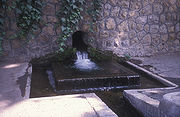
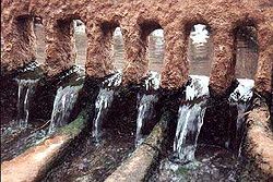
Downstream of the outlet, the water runs through surface canals called jubs (jūbs) which run downhill, with lateral branches to carry water to the neighborhood, gardens and fields. The streets normally parallel the jubs and their lateral branches. As a result, the cities and towns are oriented consistent with the gradient of the land; this is a practical response to efficient water distribution over varying terrain.
The lower reaches of the canals are less desirable for both residences and agriculture. The water grows progressively more polluted as it passes downstream. In dry years the lower reaches are the most likely to see substantial reductions in flow.
Construction
Traditionally qanats are built by a group of skilled laborers, muqannīs, with hand labor. The profession historically paid well and was typically handed down from father to son.Preparations
The critical, initial step in qanat construction is identification of an appropriate water source. The search begins at the point where the alluvial fan meets the mountains or foothills; water is more abundant in the mountains because of orographic lifting and excavation in the alluvial fanAlluvial fan
An alluvial fan is a fan-shaped deposit formed where a fast flowing stream flattens, slows, and spreads typically at the exit of a canyon onto a flatter plain. A convergence of neighboring alluvial fans into a single apron of deposits against a slope is called a bajada, or compound alluvial...
is relatively easy. The muqannīs follow the track of the main water courses coming from the mountains or foothills to identify evidence of subsurface water such as deep-rooted vegetation or seasonal seeps. A trial well is then dug to determine the location of the water table and determine whether a sufficient flow is available to justify construction. If these prerequisites are met, then the route is laid out aboveground.
Equipment must be assembled. The equipment is straightforward: containers (usually leather bags), ropes, reels to raise the container to the surface at the shaft head, hatchets and shovels for excavation, lights, spirit levels or plumb bobs and string. Depending upon the soil type, qanat liners (usually fired clay hoops) may also be required.
Although the construction methods are simple, the construction of a qanat requires a detailed understanding of subterranean geology and a degree of engineering sophistication. The gradient of the qanat must be carefully controlled—too shallow a gradient yields no flow—too steep a gradient will result in excessive erosion, collapsing the qanat. And misreading the soil conditions leads to collapses which at best require extensive rework and, at worst, can be fatal for the crew.
Excavation
Construction of a qanat is usually performed by a crew of 3-4 muqannīs. For a shallow qanat, one worker typically digs the horizontal shaft, one raises the excavated earth from the shaft and one distributes the excavated earth at the top.The crew typically begins from the destination to which the water will be delivered into the soil and works toward the source (the test well). Vertical shafts are excavated along the route, separated at a distance of 20–35 m. The separation of the shafts is a balance between the amount of work required to excavate them and the amount of effort required to excavate the space between them, as well as the ultimate maintenance effort. In general, the shallower the qanat, the closer the vertical shafts. If the qanat is long, excavation may begin from both ends at once. Tributary channels are sometimes also constructed to supplement the water flow.
Most qanats in Iran run less than 5 km, while some have been measured at ~70 km in length near Kerman
Kerman
- Geological characteristics :For the Iranian paleontologists, Kerman has always been considered a fossil paradise. Finding new dinosaur footprints in 2005 has now revealed new hopes for paleontologists to better understand the history of this area.- Economy :...
. The vertical shafts usually range from 20 to 200 meters in depth, although qanats in the province of Khorasan have been recorded with vertical shafts of up to 275 m. The vertical shafts support construction and maintenance of the underground channel as well as air interchange. Deep shafts require intermediate platforms to simplify the process of removing spoils.
The construction speed depends on the depth and nature of the ground. If the earth is easy/soft to work; at 20 meters depth, a crew of 4 people can excavate a horizontal length of 40 meters per day. When the vertical shaft reaches 40 meters, they can only excavate 20 meters horizontally per day and at 60 meters in depth this drops below 5 horizontal meters per day. In Algeria, a common speed is just 2m per day at 15m depth. Deep, long qanats (which many are) require years and even decades to construct.
The excavated material is usually transported by means of leather bags up the vertical shafts. It is mounded around the vertical shaft exit, providing a barrier that prevents windblown or rain driven debris from entering the shafts. These mounds may be covered to provide further protection to the qanat. From the air, these shafts look like a string of bomb craters.
The qanat's water-carrying channel must have a sufficient downward slope that water flows easily. However the downward gradient must not be so great as to create conditions under which the water transitions between supercritical
Supercritical flow
A supercritical flow is when the flow velocity is larger than the wave velocity. The analogous condition in gas dynamics is supersonic....
and subcritical flow; if this occurs, the waves which are established can result in severe erosion that can damage or destroy the qanat. In shorter qanats the downward gradient varies between 1:1000 and 1:1500, while in longer qanats it may be almost horizontal. Such precision is routinely obtained with a spirit level
Spirit level
A spirit level or bubble level is an instrument designed to indicate whether a surface ishorizontal or vertical . Different types of spirit levels may be used by carpenters, stonemasons, bricklayers, other building trades workers, surveyors, millwrights and other metalworkers, and in some...
and string.
In cases where the gradient is steeper, underground waterfalls may be constructed with appropriate design features (usually linings) to absorb the energy with minimal erosion. In some cases the water power has been harnessed to drive underground mills. If it is not possible to bring the outlet of the qanat out near the settlement, it is necessary to run a jub or canal overground. This is avoided when possible to limit pollution, warming and water loss due to evaporation.
Maintenance
The vertical shafts may be covered to minimize in-blown sand. The channels of qanats must be periodically inspected for erosion or cave-ins, cleaned of sand and mud and otherwise repaired. Air flow must be assured before entry for safety.Restoration
Some damaged qanats have been restored. In order to be sustainable, restoration needs to take into account many non-technical factors, beginning with the process of selecting the qanat to be restored. In the case of Syria, three sites were chosen based on a national inventory conducted in 2001. One of them, the Drasiah qanat of Dmeir, was completed in 2002. Selection criteria included the availability of a steady groundwater flow, social cohesion and willingness to contribute of the community using the qanat, and the existence of a functioning water rights system.Irrigation and drinking water supply
The primary applications of qanats are for irrigation, providing cattle with water and drinking water supply. Other applications include cooling and ice storage.Cooling
Qanats used in conjunction with a wind tower can provide cooling as well as a water supply. A wind tower is a chimney-like structure positioned above the house; of its four openings, the one opposite the wind direction is opened to move air out of the house. Incoming air is pulled from a qanat below the house. The air flow across the vertical shaft opening creates a lower pressure (see Bernoulli effectBernoulli's principle
In fluid dynamics, Bernoulli's principle states that for an inviscid flow, an increase in the speed of the fluid occurs simultaneously with a decrease in pressure or a decrease in the fluid's potential energy...
) and draws cool air up from the qanat tunnel, mixing with it. The air from the qanat was drawn into the tunnel at some distance away and is cooled both by contact with the cool tunnel walls/water and by the giving up latent heat
Latent heat
Latent heat is the heat released or absorbed by a chemical substance or a thermodynamic system during a process that occurs without a change in temperature. A typical example is a change of state of matter, meaning a phase transition such as the melting of ice or the boiling of water. The term was...
of evaporation as water evaporates into the air stream. In dry desert climates this can result in a greater than 15°C reduction in the air temperature coming from the qanat; the mixed air still feels dry, so the basement is cool and only comfortably moist (not damp). Wind tower and qanat cooling have been used in desert climates for over 1000 years.
Ice storage
The ice could be brought in during the winters from nearby mountains. But in a more usual and sophisticated method they had a wall made along east-west direction close to the Ice Pit (yakhchal
Yakhchal
Yakhchāl is an ancient type of refrigerator. The word also means "glacier" in Persian.In 400 BC Persian engineers had already mastered the technique of storing ice in the middle of summer in the desert....
).In winter the qanat water was being canalized to north side of the wall. The shadow of the wall makes water freeze more quickly so they could have more ice per each winter day. Then ice was being stored in a specially designed, naturally cooled refrigerators called yakhchal
Yakhchal
Yakhchāl is an ancient type of refrigerator. The word also means "glacier" in Persian.In 400 BC Persian engineers had already mastered the technique of storing ice in the middle of summer in the desert....
(meaning ice pits). A large underground space with thick insulated walls was connected to a qanat, and a system of windcatcher
Windcatcher
A windcatcher is a traditional Persian architectural device used for many centuries to create natural ventilation in buildings. It is not known who first invented the windcatcher, but it still can be seen in many countries today. Windcatchers come in various designs: uni-directional,...
s or Wind Towers was used to draw cool subterranean air up from the qanat to maintain temperatures inside the space at low levels, even during hot summer days. As a result, the ice melted slowly and ice was available year-round.
Qanats by country

Afghanistan
The Qanats are called KarezKariz
Kariz refers to water supply - kareez In its early beginnings, Samarkand occupied part of Mount Afrasiab , which rises to the north of today’s Samarkand. As the city grew, it expanded its borders, and by the 9th century it occupied the entire hill...
(rhymes with "raze") in Dari (Persian)
Dari (Persian)
Dari or Fārsī-ye Darī in historical terms refers to the Persian court language of the Sassanids. In contemporary usage, the term refers to the dialects of modern Persian language spoken in Afghanistan, and hence known as Afghan Persian in some Western sources. It is the term officially recognized...
and Pashto and have been in use since the pre-Islamic period. It is estimated that more than 20,000 karezes were in use in the 20th century. The oldest functional Kariz which is more than 300 years old and 8 kilometers long is located in Wardak province
Wardak Province
Maidan Wardak Province is one of thirty four provinces of Afghanistan located in the central east region of Afghanistan. It has a population of approximately 540,100. The capital of the province is Maidan Shar...
and is still providing water to nearly 3000 people. The incessant war for the last 30 years has destroyed a number of these ancient structures. In the troubled times maintenance was not always possible. To add to the troubles, as of 2008 the cost of labour has become very high and maintaining the Kariz structures is no longer possible. Lack of skilled artisans who have the traditional knowledge also poses difficulties. A number of the large farmers are abandoning their Kariz which has been in their families sometimes for centuries, and moving to tube and dug wells backed by diesel pumps.
However, the government of Afghanistan is aware of the importance of these structures and all efforts are being made to repair, reconstruct and maintain (through the community) the kariz. The Ministry of Rural Rehabilitation and Development along with National and International NGOs is making the effort.
There are still functional qanat systems in 2009. American forces
United States Army
The United States Army is the main branch of the United States Armed Forces responsible for land-based military operations. It is the largest and oldest established branch of the U.S. military, and is one of seven U.S. uniformed services...
are reported to have unintentionally destroyed some of the channels during expansion of a military base, creating tensions between them and the local community. Some of these tunnels have been used to store supplies, and to move men and equipment underground.
China
China
Chinese civilization may refer to:* China for more general discussion of the country.* Chinese culture* Greater China, the transnational community of ethnic Chinese.* History of China* Sinosphere, the area historically affected by Chinese culture...
uses water provided by qanat (locally karez). Turfan has long been the center of a fertile oasis and an important trade center along the Silk Road's northern route, at which time it was adjacent to the kingdoms of Korla
Korla
-Economy:Korla has long been the biggest centre in the region after Karashahr itself, having abundant water and extensive farmlands, as well as controlling the main routes to the south and west of Karashahr. Due to the discovery of oil in the Taklamakan Desert, Korla is now both more populous and...
and Karashahr to the southwest. The historical record of the karez system extends back to the Han Dynasty
Han Dynasty
The Han Dynasty was the second imperial dynasty of China, preceded by the Qin Dynasty and succeeded by the Three Kingdoms . It was founded by the rebel leader Liu Bang, known posthumously as Emperor Gaozu of Han. It was briefly interrupted by the Xin Dynasty of the former regent Wang Mang...
. The Turfan Water Museum (see photos on this page) is a Protected Area of the People's Republic of China
Protected Areas of the People's Republic of China
This article lists the nationally protected areas of China. There are many forms of protected areas in China. Based on their relative importance, each type of protected area can be further graded into two to three levels...
because of the importance of the local karez system
Turfan water system
The Turpan water system or Turfan water system in Turpan, located in the Turpan Depression, Xinjiang, China, is a qanat system adapted by the Turpan people. The Chinese claim the karez system as one of the three greatest water projects of China, linking it with the Dujiangyan Irrigation System...
to the history of the area. The number of karez systems in the area is slightly below 1,000 and the total length of the canals is about 5,000 kilometers.
India
In KarnatakaKarnataka
Karnataka , the land of the Kannadigas, is a state in South West India. It was created on 1 November 1956, with the passing of the States Reorganisation Act and this day is annually celebrated as Karnataka Rajyotsava...
, India, a Qanat-type structure called Suranga is used to tap underground water. However, these are rarely in use these days.
Indonesia
It has been suggested that alleged underground temples at Gua Made in JavaJava
Java is an island of Indonesia. With a population of 135 million , it is the world's most populous island, and one of the most densely populated regions in the world. It is home to 60% of Indonesia's population. The Indonesian capital city, Jakarta, is in west Java...
reached by shafts, in which masks of a green metal were found, originated as a qanat.
Iran
One of the oldest and largest known qanat is in the Iranian city of Gonabad
Gonabad
Gonabad is a city in and the capital of Gonabad County, in Razavi Khorasan Province, Iran. At the 2006 census, its population was 34,563, in 9,789 families.It is mostly well-known because of the Gonabadi Dervishes and for its qanats, also known as kareez...
which after 2,700 years still provides drinking and agricultural water to nearly 40,000 people. Its main well
Water well
A water well is an excavation or structure created in the ground by digging, driving, boring or drilling to access groundwater in underground aquifers. The well water is drawn by an electric submersible pump, a trash pump, a vertical turbine pump, a handpump or a mechanical pump...
depth is more than 360 meters and its length is 45 kilometers. Yazd
Yazd
Yazd is the capital of Yazd Province in Iran, and a centre of Zoroastrian culture. The city is located some 175 miles southeast of Isfahan. At the 2006 census, the population was 423,006, in 114,716 families....
, Khorasan and Kerman
Kerman
- Geological characteristics :For the Iranian paleontologists, Kerman has always been considered a fossil paradise. Finding new dinosaur footprints in 2005 has now revealed new hopes for paleontologists to better understand the history of this area.- Economy :...
are the known zones for their dependence with an extensive system of qanats.
In traditional Persian architecture, a Kariz (کاریز) is a small Qanat, usually within a network inside an urban setting. Kariz is what distributes the Qanat into its final destinations.
Iraq
A survey of Qanat systems in the Kurdistan region of Iraq conducted by the Department of Geography at Oklahoma State University (USA) on behalf of UNESCOUNESCO
The United Nations Educational, Scientific and Cultural Organization is a specialized agency of the United Nations...
in 2009 found that out of 683 karez systems, some 380 were still active in 2004, but only 116 in 2009. Reasons for the decline of qanats include "abandonment and neglect" previous to 2004, "excessive pumping from wells" and, since 2005, drought. Water shortages are said to have forced over 100,000 people who depended on karez systems for their livelihoods to leave their homes since 2005. The study says that a single karez has the potential to provide enough household water for nearly 9,000 individuals and irrigate over 200 hectares of farmland. UNESCO and the government of Iraq plan to rehabilitate Karez through a Karez Initiative for Community Revitalization to be launched in 2010. Most of the karez are in Sulaymaniyah Governorate (84%). A large number are also found in Erbil Governorate (13%), especially on the broad plain around and in Erbil city.
Jordan
Among the qanats built in the Roman EmpireRoman Empire
The Roman Empire was the post-Republican period of the ancient Roman civilization, characterised by an autocratic form of government and large territorial holdings in Europe and around the Mediterranean....
, the 94 km long Gadara Aqueduct
Gadara Aqueduct
The Gadara Aqueduct was an Roman aqueduct to supply water to the city of Gadara, modern-day Jordan, and the longest known tunnel of antiquity. The 170 km long pipeline was constructed in the qanat technology, that is as a series of well-like vertical shafts, which were connected underground from...
in northern Jordan
Jordan
Jordan , officially the Hashemite Kingdom of Jordan , Al-Mamlaka al-Urduniyya al-Hashemiyya) is a kingdom on the East Bank of the River Jordan. The country borders Saudi Arabia to the east and south-east, Iraq to the north-east, Syria to the north and the West Bank and Israel to the west, sharing...
was possibly the longest continuous qanat ever built.p 25, 32 Partly following the course of an older Hellenistic
Hellenistic civilization
Hellenistic civilization represents the zenith of Greek influence in the ancient world from 323 BCE to about 146 BCE...
aqueduct, excavation work arguably started after a visit by emperor Hadrian
Hadrian
Hadrian , was Roman Emperor from 117 to 138. He is best known for building Hadrian's Wall, which marked the northern limit of Roman Britain. In Rome, he re-built the Pantheon and constructed the Temple of Venus and Roma. In addition to being emperor, Hadrian was a humanist and was philhellene in...
in 129-130 AD. The Gadara Aqueduct was never quite finished and was put in service only in sections.
Pakistan
The ChagaiChagai
Chagai may refer to:* Chagai District, the largest district of Pakistan* Chagai Hills, the mountainous region north of Balochistan Province, Pakistan* Chagai, Pakistan, the capital of Chagai District*Chagai-I, the codename first nuclear weapon tests...
district
Districts of Pakistan
The Districts of Pakistan are the second order administrative divisions of Pakistan. Districts were the third order of administrative divisions, below provinces and "divisions", until the reforms of August 2000, when "divisions" were abolished...
is in the north west corner of Balochistan
Balochistan (Pakistan)
Balochistan is one of the four provinces or federating units of Pakistan. With an area of 134,051 mi2 or , it is the largest province of Pakistan, constituting approximately 44% of the total land mass of Pakistan. According to the 1998 population census, Balochistan had a population of...
, Pakistan
Pakistan
Pakistan , officially the Islamic Republic of Pakistan is a sovereign state in South Asia. It has a coastline along the Arabian Sea and the Gulf of Oman in the south and is bordered by Afghanistan and Iran in the west, India in the east and China in the far northeast. In the north, Tajikistan...
, bordering with Afghanistan
Afghanistan
Afghanistan , officially the Islamic Republic of Afghanistan, is a landlocked country located in the centre of Asia, forming South Asia, Central Asia and the Middle East. With a population of about 29 million, it has an area of , making it the 42nd most populous and 41st largest nation in the world...
and Iran
Iran
Iran , officially the Islamic Republic of Iran , is a country in Southern and Western Asia. The name "Iran" has been in use natively since the Sassanian era and came into use internationally in 1935, before which the country was known to the Western world as Persia...
. Qanats, locally known as karezes, are found more broadly in this region. They are spread from Chaghai
Chaghai
Chaghai is area in Balochistan region in Pakistan, Afghanistan and Iran.* Chagai Hills, a Pakistani nuclear test site and a region of landform in Pakistan, Afghanistan, and Iran.* Chagai-I, refers to five Pakistan's nuclear tests....
district all the way up to Zhob
Zhob
-Roads:Zhob is 333 kilometers from Quetta, 225 kilometers from Dera Ismail Khan. However, the road linking with Dera Ismail Khan is for most part fair nowadays track passing through water streams and almost complete road is metalloid....
district. A number of them are present in Qilla Abdullah
Qilla Abdullah
Qilla Abdullah or Killa Abdullah or Abdullah Qilla is the name of a fort built by Sardar Abdullah Khan Achakzai....
and Pishin
Pishin
Pishin is a small town located in the Pishin District of Balochistan province, Pakistan. It is the capital of the district, and is located in the east of the province at 30°35'0N 67°0'0E near the border with Afghanistan with an altitude of 1555 metres . Tremors from the 2008 Pakistan earthquake...
districts. Karezes are also extensively found in the neighbouring areas of Afghanistan such as Kandahar
Kandahar
Kandahar is the second largest city in Afghanistan, with a population of about 512,200 as of 2011. It is the capital of Kandahar Province, located in the south of the country at about 1,005 m above sea level...
. The remains of karezes found in different parts of the district are attributed to the Arab
Arab
Arab people, also known as Arabs , are a panethnicity primarily living in the Arab world, which is located in Western Asia and North Africa. They are identified as such on one or more of genealogical, linguistic, or cultural grounds, with tribal affiliations, and intra-tribal relationships playing...
s.
Syria
Qanats were found over much of Syria. The widespread installation of groundwater pumps has lowered the water table and qanat system. Qanats have gone dry and been abandoned across the country.Oman
In OmanOman
Oman , officially called the Sultanate of Oman , is an Arab state in southwest Asia on the southeast coast of the Arabian Peninsula. It is bordered by the United Arab Emirates to the northwest, Saudi Arabia to the west, and Yemen to the southwest. The coast is formed by the Arabian Sea on the...
from the Iron Age Period (found in Salut, Bat and other sites) a system of underground aqueducts called Falaj were constructed, a series of well-like vertical shafts, connected by gently sloping horizontal tunnels.
There are three types of Falaj: Daudi (داوودية) with underground aqueducts, Ghaili (الغيلية) requiring a dam to collect the water, and Aini (العينية) whose source is a water spring. These enabled large scale agriculture to flourish in a dry land environment.
According to UNESCO, some 3,000 aflaj (plural) or falaj (singular), are still in use in Oman today. Nizwa
Nizwa
-Attractions:The main tourist attractions in the city are Nizwa Fort, the traditional Souq and Falaj Daris. In the 1990s, the Jama, the fort and the souq which sit next to each other in the centre were renovated using the same traditional materials...
, the former capital city of Oman
Oman
Oman , officially called the Sultanate of Oman , is an Arab state in southwest Asia on the southeast coast of the Arabian Peninsula. It is bordered by the United Arab Emirates to the northwest, Saudi Arabia to the west, and Yemen to the southwest. The coast is formed by the Arabian Sea on the...
, was built around a falaj which is in use to this day. These systems date to before the Iron Age in Oman. In July 2006, five representative examples of this irrigation system were inscribed as a World Heritage Site
World Heritage Site
A UNESCO World Heritage Site is a place that is listed by the UNESCO as of special cultural or physical significance...
.
United Arab Emirates
The oasis of Al AinAl Ain
Al Ain |Spring]]), also known as the Garden City due to its greenery, is the second largest city in the Emirate of Abu Dhabi and the fourth largest city in the United Arab Emirates. With a population of 374,000 , it is located approximately 160 km east of the capital Abu Dhabi and about...
in the United Arab Emirates
United Arab Emirates
The United Arab Emirates, abbreviated as the UAE, or shortened to "the Emirates", is a state situated in the southeast of the Arabian Peninsula in Western Asia on the Persian Gulf, bordering Oman, and Saudi Arabia, and sharing sea borders with Iraq, Kuwait, Bahrain, Qatar, and Iran.The UAE is a...
continues traditional falaj (qanat) irrigations for the palm-groves and gardens.
Egypt
There are 4 main oases in the Egyptian desert. The Kharga OasisKharga Oasis
El-Kharga , also known as Al-Kharijah, is the southernmost of Egypt's five western oases. It is located in the Libyan Desert, about 200 km to the west of the Nile valley, and is some 150 km long. It is located in and is the capital of New Valley Governorate...
is one of them which has been extensively studied. As early as the second half of the 5th century BC there is evidence that water was being used via qanats. The qanat is excavated through water-bearing sandstone rock which seeps into the channel to collect in a basin behind a small dam at the end. The width is approximately 60 cm, but the height ranges from 5 to 9 meters; it is likely that the qanat was deepened to enhance seepage when the water table dropped (as is also seen in Iran). From there the water was used to irrigate fields.
There is another instructive structure located at the Kharga Oasis. A well which apparently dried up was improved by driving a side shaft through the easily penetrated sandstone (presumably in the direction of greatest water seepage) into the hill of Ayn-Manâwîr to allow collection of additional water. After this side shaft had been extended, another vertical shaft was driven to intersect the side shaft. Side chambers were built and holes bored into the rock—presumably at points where water seeped from the rocks—are evident.
Libya
Garamantes
The Garamantes were a Saharan people who used an elaborate underground irrigation system, and founded a prosperous Berber kingdom in the Fezzan area of modern-day Libya, in the Sahara desert. They were a local power in the Sahara between 500 BC and 700 AD.There is little textual information about...
area near Jarma in Libya
Libya
Libya is an African country in the Maghreb region of North Africa bordered by the Mediterranean Sea to the north, Egypt to the east, Sudan to the southeast, Chad and Niger to the south, and Algeria and Tunisia to the west....
: "The channels were generally very narrow - less than 2 feet wide and 5 high - but some were several miles long, and in total some 600 foggara extended for hundreds of miles underground. The channels were dug out and maintained using a series of regularly spaced vertical shafts, one every 30 feet or so, 100,000 in total, averaging 30 feet in depth, but sometimes reaching 130." ("The 153 Club Newsletter", July 2007 No. 112, pp. 14–19; reprinted from Current world Archaeology.
Tunisia
The foggara water management system in Tunisia, used to create oases, is similar to that of the Iranian qanat. The foggara is dug into the foothills of a fairly steep mountain range such as the eastern ranges of the Atlas mountainsAtlas Mountains
The Atlas Mountains is a mountain range across a northern stretch of Africa extending about through Morocco, Algeria, and Tunisia. The highest peak is Toubkal, with an elevation of in southwestern Morocco. The Atlas ranges separate the Mediterranean and Atlantic coastlines from the Sahara Desert...
. Rainfall in the mountains enters the aquifer and moves toward the Saharan region to the south. The foggara, 1 to 3 km in length, penetrates the aquifer and collects water. Families maintain the foggara and own the land it irrigates over a ten meter wide, with width only by the size of plot that the available water will irrigate.
Algeria
Algeria
Algeria , officially the People's Democratic Republic of Algeria , also formally referred to as the Democratic and Popular Republic of Algeria, is a country in the Maghreb region of Northwest Africa with Algiers as its capital.In terms of land area, it is the largest country in Africa and the Arab...
) are the source of water for irrigation at large oases like that at Gourara. The foggaras are also found at Touat (an area of Adrar 200 km from Gourara). The length of the foggaras in this region is estimated to be thousands of kilometers.
Although sources suggest that the foggaras may have been in use as early as 200 AD, they were clearly in use by the 11th century after the Arabs took possession of the oases in the 10th century and the residents embraced Islam.
The water is metered to the various users through the use of distribution weir
Weir
A weir is a small overflow dam used to alter the flow characteristics of a river or stream. In most cases weirs take the form of a barrier across the river that causes water to pool behind the structure , but allows water to flow over the top...
s which meter flow to the various canals, each for a separate user.
The humidity of the oases is also used to supplement the water supply to the foggara. The temperature gradient in the vertical shafts causes air to rise by natural convection, causing a draft to enter the foggara. The moist air of the agricultural area is drawn into the foggara in the opposite direction to the water run-off. In the foggara it condenses on the tunnel walls and the air passed out of the vertical shafts. This condensed moisture is available for reuse.
Morocco
In southern Morocco, the qanat (locally khettara) is also used. On the margins of the Sahara Desert, the isolated oases of the Draa RiverDraa River
The Draa is Morocco's longest river . It is formed by the confluence of the Dadès River and Imini River. It flows from the High Atlas mountains south-ward to Tagounit and from Tagounit mostly westwards to the Atlantic Ocean somewhat north of Tan-Tan...
valley and Tafilalt have relied on qanat water for irrigation since the late-14th century. In Marrakech and the Haouz plain, the qanats have been abandoned since the early 1970s as they have dried. In the Tafilaft area, half of the 400 khettaras are still in use. The Hassan Adahkil Dam's impact on local water tables is said to be one of the many reasons given for the loss of half of the khettara.
The black berbers (haratin
Haratin
Haratin are oasis-dwellers in the Sahara, especially in southern Morocco and Mauritania, who make up a socially and ethnically distinct group of largely sedentary dark colored workers speaking either Berber or Arabic...
) of the south were the hereditary class of qanat diggers in Morocco who build and repair these systems. Their work was hazardous.
Armenia
Qanats have been preserved in ArmeniaArmenia
Armenia , officially the Republic of Armenia , is a landlocked mountainous country in the Caucasus region of Eurasia...
in the community of Shvanidzor
Shvanidzor
Shvanidzor is a village and rural community in the South-East of Armenia in Syunik province . It borders with Islamic Republic of Iran. Distance between the community and Yerevan – 410 km, between the community and Kapan regional center – 102 km, between the community and the main...
, in the southern province of Syunik
Syunik
Syunik is the southernmost province of Armenia. It borders the Vayots Dzor marz to the north, Azerbaijan's Nakhchivan exclave to the west, Karabakh to the east, and Iran to the south. Its capital is Kapan. Other important cities and towns include Goris, Sisian, Meghri, Agarak, and Dastakert...
, bordering with Iran
Iran
Iran , officially the Islamic Republic of Iran , is a country in Southern and Western Asia. The name "Iran" has been in use natively since the Sassanian era and came into use internationally in 1935, before which the country was known to the Western world as Persia...
. Qanats are named kahrezes in Armenian. There are 5 kahrezes in Shvanidzor. Four of them were constructed in XII-XIVc, even before the village was founded. The fifth kahrez was constructed in 2005. Potable water runs through I, II and V kahrezs. Kahrez III and IV are in quite poor condition. In the summer, especially in July and August, the amount of water reaches its minimum, creating a critical situation in the water supply system. Still, kahrezes are the main source of potable and irrigation water for the community.
Greece
The Tunnel of Eupalinos on Samos runs for 1 kilometre through a hill to supply water to the town of Pythagorion. It was built on the order of Polycrates around 550 BC. At either end of the tunnel proper, shallow qanat-like tunnels carried the water from the spring and to the town.Italy
The 5,653 m long ClaudiusClaudius
Claudius , was Roman Emperor from 41 to 54. A member of the Julio-Claudian dynasty, he was the son of Drusus and Antonia Minor. He was born at Lugdunum in Gaul and was the first Roman Emperor to be born outside Italy...
Tunnel, meant for draining the largest Italian inland water, Fucine Lake
Fucine Lake
The Fucine Lake was a large lake in central Italy, stretching from Avezzano in the northwest to Ortuccio in the southeast, and touching Trasacco in the southwest. It was drained in 1875.-Roman drainage:...
, was constructed using the qanat technique. It featured shafts up to 122 m deep. The entire ancient town of Palermo
Palermo
Palermo is a city in Southern Italy, the capital of both the autonomous region of Sicily and the Province of Palermo. The city is noted for its history, culture, architecture and gastronomy, playing an important role throughout much of its existence; it is over 2,700 years old...
in Sicily
Sicily
Sicily is a region of Italy, and is the largest island in the Mediterranean Sea. Along with the surrounding minor islands, it constitutes an autonomous region of Italy, the Regione Autonoma Siciliana Sicily has a rich and unique culture, especially with regard to the arts, music, literature,...
was equipped with a huge qanat system built during the Arab period (827–1072). Many of the qanat are now mapped and some can be visited. The famous Scirocco room has an air-conditioning system cooled by the flow of water in a qanat and a "wind tower", a structure able to catch the wind and use it to draw the cooled air up into the room.
Luxembourg
The Raschpëtzer near HelmsangeHelmsange
Helmsange is a town in the commune of Walferdange, in central Luxembourg. , the town has a population of 2,139....
in southern Luxembourg
Luxembourg
Luxembourg , officially the Grand Duchy of Luxembourg , is a landlocked country in western Europe, bordered by Belgium, France, and Germany. It has two principal regions: the Oesling in the North as part of the Ardennes massif, and the Gutland in the south...
is a particularly well preserved example of a Roman
Ancient Rome
Ancient Rome was a thriving civilization that grew on the Italian Peninsula as early as the 8th century BC. Located along the Mediterranean Sea and centered on the city of Rome, it expanded to one of the largest empires in the ancient world....
qanat. It is probably the most extensive system of its kind north of the Alps
Alps
The Alps is one of the great mountain range systems of Europe, stretching from Austria and Slovenia in the east through Italy, Switzerland, Liechtenstein and Germany to France in the west....
. To date, some 330 m of the total tunnel length of 600 m have been explored. Thirteen of the 20 to 25 shafts have been investigated. The qanat appears to have provided water for a large Roman villa
Roman villa
A Roman villa is a villa that was built or lived in during the Roman republic and the Roman Empire. A villa was originally a Roman country house built for the upper class...
on the slopes of the Alzette
Alzette
The Alzette is a river with a length of 73 kilometers in France and Luxembourg. It is a right tributary of the Sauer.It rises in Thil near the town Villerupt in the Meurthe-et-Moselle département, France. It crosses the border with Luxembourg after a few kilometres. In Lameschmillen it is joined...
valley. It was built during the Gallo-Roman period, probably around the year 150 and functioned for about 120 years thereafter.
Spain
There are still many examples of galeria or qanat systems in SpainSpain
Spain , officially the Kingdom of Spain languages]] under the European Charter for Regional or Minority Languages. In each of these, Spain's official name is as follows:;;;;;;), is a country and member state of the European Union located in southwestern Europe on the Iberian Peninsula...
, most likely brought to the area by the Moors
Moors
The description Moors has referred to several historic and modern populations of the Maghreb region who are predominately of Berber and Arab descent. They came to conquer and rule the Iberian Peninsula for nearly 800 years. At that time they were Muslim, although earlier the people had followed...
during their occupation of the Iberian peninsula
Iberian Peninsula
The Iberian Peninsula , sometimes called Iberia, is located in the extreme southwest of Europe and includes the modern-day sovereign states of Spain, Portugal and Andorra, as well as the British Overseas Territory of Gibraltar...
. Turrillas
Turrillas
The annual fiesta, in honor of San Antonio takes place on June 13,14,and 15 of every year, Celebrations go late into the night, with a concert taking place on the town square, live music and bars. There is also a parade on horseback past La ermita de San Antonio, which is situated in the lower part...
in Andalusia
Andalusia
Andalusia is the most populous and the second largest in area of the autonomous communities of Spain. The Andalusian autonomous community is officially recognised as a nationality of Spain. The territory is divided into eight provinces: Huelva, Seville, Cádiz, Córdoba, Málaga, Jaén, Granada and...
on the north facing slopes of the Sierra de Alhamilla has evidence of a qanat system. Granada
Granada
Granada is a city and the capital of the province of Granada, in the autonomous community of Andalusia, Spain. Granada is located at the foot of the Sierra Nevada mountains, at the confluence of three rivers, the Beiro, the Darro and the Genil. It sits at an elevation of 738 metres above sea...
is another site with an extensive qanat system.
The Americas
Qanats in the Americas, usually referred to as filtration galleries, can be found in the Nazca region of Peru and in northern Chile. The Spanish introduced qanats into Mexico in 1520 AD.See also
- YakhchalYakhchalYakhchāl is an ancient type of refrigerator. The word also means "glacier" in Persian.In 400 BC Persian engineers had already mastered the technique of storing ice in the middle of summer in the desert....
, ancient natural refrigerators in Persia. - Traditional water sources of Persian antiquityTraditional water sources of Persian antiquityMost rivers in Iran are seasonal and have traditionally not been able to supply the needs of urban settlements. Major rivers like the Arvand, Aras, Zayandeh, Sefid and Atrak were few and far between in the vast lands of Persian antiquity....
- Menara gardensMenara gardensThe Menara gardens are gardens located to the west of Marrakech, Morocco, at the gates of the Atlas mountains. They were built in the 12th century by the Almohad ruler Abd al-Mu'min....
- OasisOasisIn geography, an oasis or cienega is an isolated area of vegetation in a desert, typically surrounding a spring or similar water source...
- Ab AnbarAb AnbarAn āb anbār is a traditional reservoir or cistern of drinking water in Persian antiquity. The Persian phrase literally translates as "water reservoir".-The structure:...
External links
- WaterHistory.org Article on Karez in Turpan, Xinjiang, China
- World Wildlife Fund Editorial on Karez in Afghanistan
- Useful information on Qanat provided by Farzad Kohandel, in arabic) and in english
- Qanat
- Information on Qanats (includes photo of access shafts from above)
- Site includes discussion of use of qanats in Libya
- International Center on Qanats and Historic Hydraulic Structures
- The origin and spread of qanats in the Old World - by PW English, in Proceedings of the American Philosophical Society Volume 112, Number 3 June 21, 1968.
- The art and science of water, in Saudi Aramco May/June 2006
- Turpan, China
- Carlo Trabia: “Kanats of Sicily”, in: Best of Sicily Magazine, March 2005, with Photo
- http://www.hamsayeh.net/travel%20and%20tourism%20qanat%20in%20Isfahan.htm A visit inside a qanat in Ghehi-Isfahan
- Lynn Teo Simarski, Oman's "Unfailing Springs", 1992, Saudi Aramco World