

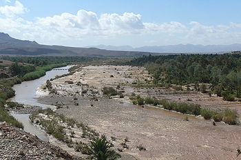
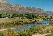
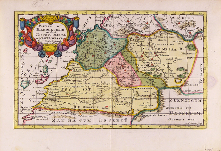
Draa River
Encyclopedia
Morocco
Morocco , officially the Kingdom of Morocco , is a country located in North Africa. It has a population of more than 32 million and an area of 710,850 km², and also primarily administers the disputed region of the Western Sahara...
's longest river (1100 km). It is formed by the confluence of the Dadès River
Dadès River
Dadès River is a river in Morocco, located at .-Geography:The Dadès River rises in the High Atlas and then turns south crossing through the Dadès Gorge, then westward between the High Atlas and Anti-Atlas mountain ranges. The river finally meets the Ouarzazate River, which then enters Draa...
and Imini River
Imini River
Imini River is a river in Morocco, located at . It flows from eastern Atlas Mountains and enters Draa River. It provides the surrounding areas with lush green grass and fresh water....
. It flows from the High Atlas mountains south-(east)ward to Tagounit and from Tagounit mostly westwards to the Atlantic Ocean somewhat north of Tan-Tan
Tan-Tan
Tan-Tan is a city in Tan-Tan Province in southern Morocco. It is a desert town with a small population, with only few claims to fame:*The nearby port, Tan-Tan Plage, or Port of Tan-Tan, about 25 kilometres away from Tan-Tan itself...
. Most of the year the part of the Draa after Tagounit falls dry.
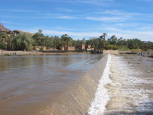
The water from the Draa is used to irrigate palm groves and small horticulture along the river. The inhabitants of the Draa are called Drawa (an exonym), the most famous Drawi (singular of Drawa) undoubtedly being mawlay Mohammed ash-Sheikh
Mohammed ash-Sheikh
Mawlay Mohammed ash-Sheikh ash Sharif al-Hassani al-Drawi at-Tagmadert was the first sultan of the Saadi dynasty ruling over Morocco . "Al-Drawi at-Tagmadert" means: the man from the Draa river valley, from Tagmadert. He was particularly successful in expelling the Portuguese from most of their...
. Outside of the Draa region this name is mostly used to refer to the dark skinned people of Draa which make up the largest portion of its inhabitants.
In the first half of the twentieth century the Draa lowest course marked the boundary between the French protectorate of Morocco and the South Zone of the Spanish
Spanish Morocco
The Spanish protectorate of Morocco was the area of Morocco under colonial rule by the Spanish Empire, established by the Treaty of Fez in 1912 and ending in 1956, when both France and Spain recognized Moroccan independence.-Territorial borders:...
one. Presently part of its upper course marks a part of the international boundary between Algeria and Morocco
Sand War
The Sand War or Sands War occurred along the Algerian-Moroccan border in October 1963, and was a Moroccan attempt to claim the Tindouf and the Béchar areas that France had annexed to French Algeria a few decades earlier.- Background :...
.
225,000 people live in the valley of the Draa, which measures 23,000 km². The valley corresponds with the province of Zagora, created in 1997, in the Souss-Massa-Draâ
Souss-Massa-Draâ
Souss-Massa-Draâ is one of the sixteen regions of Morocco. It is situated in central Morocco. It covers an area of 70,880 km² and has a population of 3,113,653 . The capital is Agadir...
region. In the province there are 23 villages and two towns: Zagora
Zagora, Morocco
Zagora is a town in the valley of the Draa River in Souss-Massa-Draâ, southeastern Morocco. It is located at around . It is flanked by the mountain Zagora from which the town got its name. Originally it was called 'Tazagourt' the singular of plural 'Tizigirt' , Berber for 'twinpeaks', referring...
and Agdz
Agdz
Agdz or Agdez is a town in southeastern Morocco, in the Atlas Mountains. It is located at around . Agdz lies at the feet of Djebel Kissane and along the shores of the Draa River....
. The village of Tamegroute
Tamegroute
Tamegroute is a village in the south of Morocco, in the valley of the Draa River. It has a history as an important center of learning and religion through its famous Sufi zawiya, historical center of the Nasiriyya Sufi order, one of the most influential - and at one time one of the largest - Sufi...
, near Zagora, is well known for its Zawiya.
Prehistory
The pre-history of the valley of the Draa goes back thousands of years, as is evidenced by the many rock artRock art
Rock art is a term used in archaeology for any human-made markings made on natural stone. They can be divided into:*Petroglyphs - carvings into stone surfaces*Pictographs - rock and cave paintings...
engravings or petroglyph
Petroglyph
Petroglyphs are pictogram and logogram images created by removing part of a rock surface by incising, picking, carving, and abrading. Outside North America, scholars often use terms such as "carving", "engraving", or other descriptions of the technique to refer to such images...
s in its surroundings and most of all by the find of the Venus of Tan-Tan
Venus of Tan-Tan
The Venus of Tan-Tan is an alleged artifact found in Morocco.It and its contemporary, the Venus of Berekhat Ram, have been claimed as the earliest representations of the human form.-Description:...
. This statue is possibly the oldest human figurine ever found. It dates back more than three hundred thousand years.
From all main periods of the prehistory of the Sahara rock-engravings and rock-paintings have been found. Foum Chenna (Tinzouline), Aït Ouaazik ( Asguine Tarna, Tazzarine) Tiouririne e Tisguinine (Zagora) are amongst the best known sites in the Draa region. At lghir N'tidri between Tagunit and Mhamid al-Ghizlane there is the necropolis of Foum Larjam. The necropolis is the largest of North Africa and consists of several kilometers of tumuli and dates back to prehistoric times. It is one of the few sites where not just rock-drawings but also rock-paintings were found. An extensive investigation into the precise date and origin of its (sedentary) inhabitants has yet to be made.
See also: Saharan rock art
Saharan rock art
Saharan rock art is a significant area of archaeological study focusing on the precious treasures carved or painted on the natural rocks found in the central Sahara desert. There are over three thousand sites discovered that have information about Saharan rock art...
, Rock art of Figuig
Rock art of Figuig
The rock art of the Figuig region of Morocco consists of prehistoric engravings of the Neolithic age. They belong to the wide south Algerian group "Sud-oranais" . They are east of the rock art of the Atlas mountains...
, Rock art of south Oran (Algeria)
Rock art of south Oran (Algeria)
The rock art of south Oran, are prehistoric engravings of Neolithic age in the south of Oran Province, Algeria, in the Saharan Atlas Mountains, in the regions of Figuig, Ain Sefra, El-Bayadh, Aflou and Tiaret. Comparable engravings have been described, even further east, around Djelfa and in the...
, Tadrart Acacus
Tadrart Acacus
The Acacus Mountains or Tadrart Acacus form a mountain range in the desert of the of the Ghat District in western Libya, part of the Sahara. They are situated east of the Libyan city of Ghat and stretch north from the Algerian border about 100 km. Tadrart means 'mountain' in the native...
, Rock art
Rock art
Rock art is a term used in archaeology for any human-made markings made on natural stone. They can be divided into:*Petroglyphs - carvings into stone surfaces*Pictographs - rock and cave paintings...
, Petroglyph
Petroglyph
Petroglyphs are pictogram and logogram images created by removing part of a rock surface by incising, picking, carving, and abrading. Outside North America, scholars often use terms such as "carving", "engraving", or other descriptions of the technique to refer to such images...
, Neolithic
Neolithic
The Neolithic Age, Era, or Period, or New Stone Age, was a period in the development of human technology, beginning about 9500 BC in some parts of the Middle East, and later in other parts of the world. It is traditionally considered as the last part of the Stone Age...
Before 1054
Hanno the Navigator
Hanno the Navigator was a Carthaginian explorer c. 500 BC, best known for his naval exploration of the African coast...
a king of Carthage
Carthage
Carthage , implying it was a 'new Tyre') is a major urban centre that has existed for nearly 3,000 years on the Gulf of Tunis, developing from a Phoenician colony of the 1st millennium BC...
(living around 550 B.C.) who set out for a mission to establish a colony on the west coast of Africa. The Punic text of the record of this journey (known as the Periplus
Periplus
Periplus is the Latinization of an ancient Greek word, περίπλους , literally "a sailing-around." Both segments, peri- and -plous, were independently productive: the ancient Greek speaker understood the word in its literal sense; however, it developed a few specialized meanings, one of which became...
) was engraved in the Temple of Chronos (Baal Hammon) at Carthage
Carthage
Carthage , implying it was a 'new Tyre') is a major urban centre that has existed for nearly 3,000 years on the Gulf of Tunis, developing from a Phoenician colony of the 1st millennium BC...
. There is only one Greek version, dating perhaps to the 3rd century B.C. These are the opening words of the Periplus:
“The Voyage of Hanno, King of the Carthaginians, to the Libyan regions of the earth, beyond the Pillars of Heracles...”
Having visited the Carthaginian colonies of the Atlas in Morocco, Hanno proceeded southward:
"Leaving this place we arrived at the great river Lixos which comes from Libya. On the banks nomads, the Lixites, were feeding their flocks. We stayed for some time with these people and made friends with them. Upstream from them lived the unfriendly Ethiopians whose land is full of wild beasts and broken up by high mountains where they say the Lixos flows from. They also say that about these mountains dwell the strange-looking Troglodytes. The Lixites claim that they can run faster than horses. Taking Lixite interpreters with us we sailed alongside the desert in a southerly direction for two days, then towards the rising sun for one more day. We then found at the far end of an inlet a little island five stades in circumference. We named it Cerne (Some scholars identify Kerne with the Island of Herne (23°50’N) on the coast of the Sahara) and left settlers there. judging by our journey we reckoned that it must be opposite Carthage, since we had to sail the same distance from Carthage to the Pillars of Hercules
Pillars of Hercules
The Pillars of Hercules was the phrase that was applied in Antiquity to the promontories that flank the entrance to the Strait of Gibraltar. The northern Pillar is the Rock of Gibraltar in the British overseas territory of Gibraltar...
as from the Pillars of Hercules to Cerne."
It is generally agreed, the Lixos can be identified as the Draa (28°45’N). The Draa is the largest river in the area, and marks the southernmost limit of cultivable land. This well corresponds to Hanno’s account. Certainly the area of Herne was known to the Carthaginians because they would hardly have sent a colony to an unknown place.
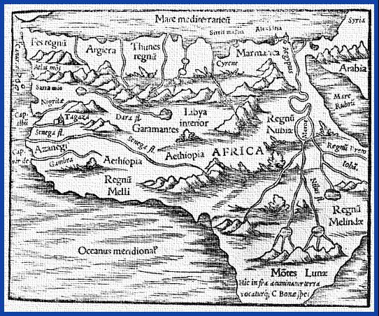
The Draa River was also well known to the ancient Romans. It figures on the first world map in history made by Ptolemy
Geographia (Ptolemy)
The Geography is Ptolemy's main work besides the Almagest...
(90-168 AD).
When in 680 Uqba ibn Nafi
Uqba ibn Nafi
Uqba ibn Nafi was an Arab hero and general who was serving the Umayyad dynasty, in Amir Muavia and Yazid periods, who began the Islamic conquest of the Maghreb, including present-day Algeria, Tunisia, Libya and Morocco in North Africa. He was the nephew of 'Amr ibn al-'As. Uqba is often surnamed...
the governor of Ifriqiya
Ifriqiya
In medieval history, Ifriqiya or Ifriqiyah was the area comprising the coastal regions of what are today western Libya, Tunisia, and eastern Algeria. This area included what had been the Roman province of Africa, whose name it inherited....
came to Morocco with his Arab army, and fought the Masmuda
Masmuda
The Masmuda were a Berber tribal confederacy of Morocco and one of the largest in the Maghreb, along with the Zanata and the Sanhaja. They were composed of several sub-tribes: The Berghouatas, Ghumaras , Hintatas , Tinmelel, Hergha, Genfisa, Seksiwa, Gedmiwa, Hezerdja, Urika, Guerouanes, Bni...
a tribe of the Atlas mountains
Atlas Mountains
The Atlas Mountains is a mountain range across a northern stretch of Africa extending about through Morocco, Algeria, and Tunisia. The highest peak is Toubkal, with an elevation of in southwestern Morocco. The Atlas ranges separate the Mediterranean and Atlantic coastlines from the Sahara Desert...
, they consequently fled to the Draa river valley; Ukba pursued them and inflicted a crushing defeat on them there. Ukba continued his conquest to the Atlantic ocean, but on his return march to Kayrawan he was defeated and killed. Thereafter part of the Draa river valley was inhabited by the (Sanhadja) tribe of the Masufa. Their city in this region was called Tiyumetin (modern day Tagounit). From this time until today also the presence of Jewish groups in the Draa valley is attested. Beni Sbih and Beni Hayoune are the villages that remain of that past.
Almoravids
Almoravids
The Almoravids were a Berber dynasty of Morocco, who formed an empire in the 11th-century that stretched over the western Maghreb and Al-Andalus. Their capital was Marrakesh, a city which they founded in 1062 C.E...
began their advance on central Morocco. Their very first campaign was on the valley of the Draa river. The power in the valley had been, like in the city of Sijilmasa
Sijilmasa
Sijilmasa was a medieval trade entrepôt at the northern edge of the Sahara Desert in Morocco. The ruins of the town lie along the River Ziz in the Tafilalt oasis near the town of Rissani...
, for some 50 years in the hands of the Marghwata (a branch of the Zenata
Zenata
Zenata were an ethnic group of North Africa, who were technically an Eastern Berber group and who are found in Tunisia, Algeria and Morocco....
). Here and elsewhere in Morocco this domination was resented. After the Almoravids
Almoravids
The Almoravids were a Berber dynasty of Morocco, who formed an empire in the 11th-century that stretched over the western Maghreb and Al-Andalus. Their capital was Marrakesh, a city which they founded in 1062 C.E...
had conquered the Draa and Sijilmasa
Sijilmasa
Sijilmasa was a medieval trade entrepôt at the northern edge of the Sahara Desert in Morocco. The ruins of the town lie along the River Ziz in the Tafilalt oasis near the town of Rissani...
they went on to conquer Adaghwast at the southern end of the trans-Sahara route. Yusuf ibn Tashfin
Yusuf ibn Tashfin
Yusef ibn Tashfin also, Tashafin, or Teshufin; or Yusuf; was a king of the Almoravid empire, he founded the city of Marrakech and led the Muslim forces in the Battle of Zallaqa....
took command of North Morocco, while Abu-Bakr Ibn-Umar
Abu-Bakr Ibn-Umar
Abu Bakr ibn Umar ibn Ibrahim ibn Turgut, sometimes suffixed al-Sanhaji or al-Lamtuni was a chieftan of the Lamtuna Berbers of the western Sahara, and commander of the Almoravids from 1056 until his death....
was leader in the Sahara
Sahara
The Sahara is the world's second largest desert, after Antarctica. At over , it covers most of Northern Africa, making it almost as large as Europe or the United States. The Sahara stretches from the Red Sea, including parts of the Mediterranean coasts, to the outskirts of the Atlantic Ocean...
, Tafilalt and the Draa. Today the remains of an Almoravid
Almoravids
The Almoravids were a Berber dynasty of Morocco, who formed an empire in the 11th-century that stretched over the western Maghreb and Al-Andalus. Their capital was Marrakesh, a city which they founded in 1062 C.E...
fortress can still be seen on the top of the Zagora
Zagora, Morocco
Zagora is a town in the valley of the Draa River in Souss-Massa-Draâ, southeastern Morocco. It is located at around . It is flanked by the mountain Zagora from which the town got its name. Originally it was called 'Tazagourt' the singular of plural 'Tizigirt' , Berber for 'twinpeaks', referring...
hill. There are still groups in the Draa valley that claim descendancy from the Almoravids
Almoravids
The Almoravids were a Berber dynasty of Morocco, who formed an empire in the 11th-century that stretched over the western Maghreb and Al-Andalus. Their capital was Marrakesh, a city which they founded in 1062 C.E...
: the groups of Mrabtine linked to the Arib and the Msouffa, part of the confederation of the Ait Atta
Ait Atta
The Ait Atta are a large Berber tribal confederation of North eastern Morocco, estimated to number about 130,000 as of 1960. They are divided into "five fifths" , all said to descend from the forty sons of their common ancestor Dadda Atta: these "fifths" are the Ait Ouallal, Ait Ouahlim, Ait...
. This integration in the empire of the Almoravids
Almoravids
The Almoravids were a Berber dynasty of Morocco, who formed an empire in the 11th-century that stretched over the western Maghreb and Al-Andalus. Their capital was Marrakesh, a city which they founded in 1062 C.E...
was also was the first integration of the Draa valley into the whole of Morocco.
Many times, however, the Draa valley was the cradle of revolution and dissent. In 1255 the Bani Hassan (the Maqil
Maqil
The Maqil were an Arabian nomadic tribe that emigrated to the Maghreb region, with the Banu Hillal and Banu Sulaym tribes, in the 11th century. They mainly settled in and around Morocco's Saharan wolds and oases; in Tafilalet, Wad Nun , Draa and Taourirt...
Arabs) invaded the valley. The Maqil
Maqil
The Maqil were an Arabian nomadic tribe that emigrated to the Maghreb region, with the Banu Hillal and Banu Sulaym tribes, in the 11th century. They mainly settled in and around Morocco's Saharan wolds and oases; in Tafilalet, Wad Nun , Draa and Taourirt...
were quickly used by the ruling Berber dynasties. In the country-side however they were deeply disruptive, bringing ruin to many sedentary farmers. The domination of the Maqil
Maqil
The Maqil were an Arabian nomadic tribe that emigrated to the Maghreb region, with the Banu Hillal and Banu Sulaym tribes, in the 11th century. They mainly settled in and around Morocco's Saharan wolds and oases; in Tafilalet, Wad Nun , Draa and Taourirt...
in the south lasted to the middle of the 14th century, when a large part of them moved further north and many Berber inhabitants came back. Others like the Roha, Oulad Yahia and Ouled Malek (still a part of the population), which arrived later in the Draa valley, stayed there and continued the fight for the rule of the region. In the 15th century some struggle between Arabs and Berber continued.
Saadi
At this time the region was the home of many important religious figures and zaouias. The Draa became part of the maraboutMarabout
A marabout is a Muslim religious leader and teacher in West Africa, and in the Maghreb. The marabout is often a scholar of the Qur'an, or religious teacher. Others may be wandering holy men who survive on alms, Sufi Murshids , or leaders of religious communities...
mouvement against the Portuguese
Portugal
Portugal , officially the Portuguese Republic is a country situated in southwestern Europe on the Iberian Peninsula. Portugal is the westernmost country of Europe, and is bordered by the Atlantic Ocean to the West and South and by Spain to the North and East. The Atlantic archipelagos of the...
who had captured many towns at the Atlantic coast. The Draa made an important come back in the history of Morocco with the rise of the dynasty of the Saadi
Saadi Dynasty
The Saadi dynasty of Morocco , began with the reign of Sultan Mohammed ash-Sheikh in 1554, when he vanquished the last Wattasids at the Battle of Tadla....
or Bani Zaydan as their original name was. Its cradle was in the Draa valley in Tagmadert
Tagmadert
Tagmadert is a famous place in the Draa River valley. It is the place of origin of the members of the Saadi Dynasty. Despite the fact that Tagmadert is indicated on most older European maps, there is some uncertainty about its exact location...
, the current district of Fezouata between Zagora
Zagora
Zagora may refer to:*Zagora, Morocco*Zagora Province, Morocco*Zagora, Greece* The region Zagore in north-eastern Bulgaria*The city of Stara Zagora*The city of Nova Zagora*Zagora , a region in inland Dalmatia...
and Tamegroute
Tamegroute
Tamegroute is a village in the south of Morocco, in the valley of the Draa River. It has a history as an important center of learning and religion through its famous Sufi zawiya, historical center of the Nasiriyya Sufi order, one of the most influential - and at one time one of the largest - Sufi...
. Although there is still a village called Timidert today, some historians think Tagmadert
Tagmadert
Tagmadert is a famous place in the Draa River valley. It is the place of origin of the members of the Saadi Dynasty. Despite the fact that Tagmadert is indicated on most older European maps, there is some uncertainty about its exact location...
was situated at today's Amezrou, a village next to Zagora. Thanks to the Saadi Dynasty
Saadi Dynasty
The Saadi dynasty of Morocco , began with the reign of Sultan Mohammed ash-Sheikh in 1554, when he vanquished the last Wattasids at the Battle of Tadla....
the Draa played an important role in the history of Morocco
History of Morocco
The History of Morocco spans over 12 centuries, without considering the Classical antiquity. The country was first unified by the Idrisid dynasty in 780, representing the first Islamic state in Africa autonomous from the Arab Empire. Under the Almoravid dynasty and the Almohad dynasty, Morocco...
and the Sahara
Sahara
The Sahara is the world's second largest desert, after Antarctica. At over , it covers most of Northern Africa, making it almost as large as Europe or the United States. The Sahara stretches from the Red Sea, including parts of the Mediterranean coasts, to the outskirts of the Atlantic Ocean...
during the 16th century. In the middle of that century the Saadi Dynasty
Saadi Dynasty
The Saadi dynasty of Morocco , began with the reign of Sultan Mohammed ash-Sheikh in 1554, when he vanquished the last Wattasids at the Battle of Tadla....
was at the height of its power. In that time the need for gold was increasing and the sultan Ahmad al-Mansur decided to undertake the conquest of the Soudan in 1590. According to some sources this conquest had its cause in the events of 1545 when under the reign of Mohammed ash-Sheikh
Mohammed ash-Sheikh
Mawlay Mohammed ash-Sheikh ash Sharif al-Hassani al-Drawi at-Tagmadert was the first sultan of the Saadi dynasty ruling over Morocco . "Al-Drawi at-Tagmadert" means: the man from the Draa river valley, from Tagmadert. He was particularly successful in expelling the Portuguese from most of their...
the palm orchards of the Ktawa in the Draa were captured by the Tuareg Oulmiden who were sent by Ishaq I, king of the Sudan.
The campaign for the conquest of the Sudan started in the Ktawa, in the Draa valley. Its was in 1591 that the troops gathered and took in food for the passage across the desert. After the military operations the trans-Sahara trade with the Sudan seems to have intensified. In the palm gardens of M'hamid between ksar
Ksar
Ksar is the Arabic term for "castle", loaned from Latin castrum.The Berber equivalent is aghrem or ighrman ....
Bounou and ksar
Ksar
Ksar is the Arabic term for "castle", loaned from Latin castrum.The Berber equivalent is aghrem or ighrman ....
Talha the ruins of qsar El Alouj are still to be found. This was the old "customs office" where the gold pouder arrived from the Sudan. Here the gold coins were struck to be send to Marrakesh. With the decline of the Saadi Dynasty
Saadi Dynasty
The Saadi dynasty of Morocco , began with the reign of Sultan Mohammed ash-Sheikh in 1554, when he vanquished the last Wattasids at the Battle of Tadla....
, especially after the death of Ahmad al-Mansur in 1603 the Draa falls back into anarchy.
Alouites
Alaouite Dynasty
The Alaouite Dynasty is the name of the current Moroccan royal family. The name Alaouite comes from the ‘Alī of its founder Moulay Ali Cherif who became Prince of Tafilalt in 1631. His son Mulay r-Rshid was able to unite and pacify the country...
succeeds in establishing its authority in the valley. They conquer the Draa in 1642 where they, like their predecessors, construct numerous ksour
Ksar
Ksar is the Arabic term for "castle", loaned from Latin castrum.The Berber equivalent is aghrem or ighrman ....
. They rule by military force and it is no longer from Tagmadert
Tagmadert
Tagmadert is a famous place in the Draa River valley. It is the place of origin of the members of the Saadi Dynasty. Despite the fact that Tagmadert is indicated on most older European maps, there is some uncertainty about its exact location...
that they reign the country, but from d’Aghlan, some 20 km North of Zagora. Amezrou, however becomes the seat of the governor. Later in the 17th century Mawlay Ismail Ibn Sharif
Ismail Ibn Sharif
Moulay Ismaïl Ibn Sharif was the second ruler of the Moroccan Alaouite dynasty. Like others of the dynasty, Ismaïl claimed to be a descendant of Muhammad through his roots to Hassan ibn Ali...
sends his son to stay in Beni Zouli and also in the zaouia
Zaouia
A zaouia or zawiya is an Islamic religious school or monastery. The term is Maghrebi and West African, roughly corresponding to the Eastern term madrassa...
Nasiriyya
Nasiriyya
The Nasiriyya is a Sufi order founded by Sidi Mohammed ibn Nasir al-Drawi whose centre was Tamegroute-Bibliography:* Ph.D. Thesis: by David Gutelius. Johns Hopkins University, 2001....
of Tamgroute in 1675/76. A military expedition sent by Moulay Ismail Ibn Sharif
Ismail Ibn Sharif
Moulay Ismaïl Ibn Sharif was the second ruler of the Moroccan Alaouite dynasty. Like others of the dynasty, Ismaïl claimed to be a descendant of Muhammad through his roots to Hassan ibn Ali...
to suppress a rebellion in Mhamid Ghuzlan was led by an Englishman called Thomas Pellow who spent 23 years in Morocco. Pellow wrote a book with an account of his experiences..
In the two next centuries the Draa remains the object of fights between warring (nomadic) tribes. Unfortunately sources have paid too little attention to the sedentary population to give a complete picture of its history and evolution. The officers of the colonising French were almost exclusively interested in the neighbouring resisting warrior tribe ot the Ait Atta
Ait Atta
The Ait Atta are a large Berber tribal confederation of North eastern Morocco, estimated to number about 130,000 as of 1960. They are divided into "five fifths" , all said to descend from the forty sons of their common ancestor Dadda Atta: these "fifths" are the Ait Ouallal, Ait Ouahlim, Ait...
and neglected the Ktawa of the Draa. It is probable, however, that during these last centuries the nomad tribes in the Draa valley have integrated with the sedentary. Blood ties (real or imaginary) in which the determining factor whether one belonged to this or that tribe or sub-tribe make place for the determining factor of the qsour where one lives. Alliances are made between particular qsour and nomad groups which offer protection. At the end of the 18th century the power in the Ktawa is divided between tree chiefs of three groups: the caid Mohamed in the qsour Beni Hayoun, cheik El Maati in the Beni Sbih and cheik Aamaou in the upper part of the valley. Around 1800 the security of these qsour was threatened by Arab nomads like the Ghenama and the Beni Mohammed and the protection of the Ait Atta was invoked. The price the sedentary groups paid for the protection was a part of their land. This method was custom at many places throughout the valley. Certain qsour however remained independent under the protection of their local chiefs or zawiyas (e.g. qsour Mezguita). Much of the history of the Draa valley is characterised by the warfare between different tribes and most of all by the crimes these tribes committed against the local Drawa population.
20th century
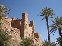
With the coming of the Glaoua at the beginning of the 20th century the domination of many of the ksour by the nomads (like Ait Atta) is brought to an end. Later in the 1930s the French colonisation slowly, but completely ends the nomad influence and social structures are radically changed. The jemaa is moved to Tagounit, the new administrative centre, and after a few years the region enjoys a new kind of autonomy.Kasbahs
Kasbah
A kasbah or qassabah is a type of medina, Islamic city, or fortress .It was a place for the local leader to live and a defense when a city was under attack. A kasbah has high walls, usually without windows. Sometimes, they were built on hilltops so that they could be more easily defended...
s. The most famous kasbahs in the region are (north to south):
- The kasbah of TamnougaltTamnougaltTamnougalt is a village in the Draa River valley in Morocco, some 95 kilometers south of Ouarzazat. The village is close to Agdz and has a famous kasbah. It is the former capital of the Mezguita region and residence of former caïds. Its name means 'meeting point' in Tachelhit...
(the kasbah of Caïd Ali) and the kasbah of Aït Hammou Ousaid (or Mouha ou Hammou ZayaniMouha ou Hammou ZayaniMouha Ou Hammou Zayani, by his full name: Mohammed ou Hammou ben Akka ben Ahmed, also known as Amahzoune ben Moussa , was made Caïd of the Zayanes in Khénifra by sultan Moulay Hassan I in 1886...
) near AgdzAgdzAgdz or Agdez is a town in southeastern Morocco, in the Atlas Mountains. It is located at around . Agdz lies at the feet of Djebel Kissane and along the shores of the Draa River....
. - The kasbah of El Caïd Ouslim and the kasbah of Oulad Outhmane in Tamezmout.
- The kasbah of Foum Achnna and the kasbah of N'Kob in Tinzouline
- The kasbah of Tat Ifli in Beni Zouli.
- The kasbah of Amezrou, of Aït Ali Tighramt Ouziguen and of Laglaoui in ZagoraZagoraZagora may refer to:*Zagora, Morocco*Zagora Province, Morocco*Zagora, Greece* The region Zagore in north-eastern Bulgaria*The city of Stara Zagora*The city of Nova Zagora*Zagora , a region in inland Dalmatia...
- The kasbah of Agouim Nouaadjou and the kasbah of Tagounite in Tagounite.
- The kasbah of Aït Bounou, of LaAllouj, the kashbah of Oulad Driss and the kasbah of the Rgabi in M'hamid El Ghuzlane.
Agriculture
Berber people
Berbers are the indigenous peoples of North Africa west of the Nile Valley. They are continuously distributed from the Atlantic to the Siwa oasis, in Egypt, and from the Mediterranean to the Niger River. Historically they spoke the Berber language or varieties of it, which together form a branch...
oases in North Africa
North Africa
North Africa or Northern Africa is the northernmost region of the African continent, linked by the Sahara to Sub-Saharan Africa. Geopolitically, the United Nations definition of Northern Africa includes eight countries or territories; Algeria, Egypt, Libya, Morocco, South Sudan, Sudan, Tunisia, and...
(Siwa
Siwa
Siwa may refer to:* 140 Siwa, an asteroid* Siwa, Indonesian pronunciation of the Hindu god Shiva* Siwa , spider genus in the Araneidae family* Siwa Oasis, an oasis in Egypt* Siwa, Panchthar, a Village Development Committee in Nepal...
, Kufra
Kufra
Kufra is a basin and oasis group in Al Kufrah District, southeastern Cyrenaica in Libya. Kufra is historically important above all because at the end of nineteenth century it became the center and holy place of the Senussi order...
, Ouargla
Ouargla
Ouargla is the capital city of Ouargla province, in the Sahara Desert, in southern Algeria. It has a flourishing oil industry, and hosts one of Algeria's universities. The city had a population of 129,402 in 1998 ....
) the Draa valley was known for its qatarra, a sophisticated system of underground irrigation canals.
Language
The people of the Draa speak, besides Arabic, their own variant of the Berber dialect Tashelhiyt.Tashelhiyt is sub-divided into Tachelhiyt of the Draa valley, Tasusit (the language of the Souss) and several other (mountain)-dialects. Tashelhiyt of the Draa is also spoken in Tabelbala
Tabelbala
Tabelbala is an oasis between Béchar and Tindouf in southwestern Algeria, notable for being the only town in Algeria to speak a language neither Arabic nor Berber, Korandje.Tabelbala is divided into four settlements...
(Algeria). In the Imini region Judeo-Berber was spoken in the first half of the 20th century.
Oases
The Upper Draa River valley (ca 200 km long) consists of six stretches of oases/palm groves from north to south:- The Mezguita oasis, with the AgdzAgdzAgdz or Agdez is a town in southeastern Morocco, in the Atlas Mountains. It is located at around . Agdz lies at the feet of Djebel Kissane and along the shores of the Draa River....
and Auriz and south of it the Tamsikht dam - The oasis of Tinzouline, with Ouled Lagraier, Tinzouline, Ouled Yaoub and a dam south of it
- The Ternata oasis with ZagoraZagoraZagora may refer to:*Zagora, Morocco*Zagora Province, Morocco*Zagora, Greece* The region Zagore in north-eastern Bulgaria*The city of Stara Zagora*The city of Nova Zagora*Zagora , a region in inland Dalmatia...
- The Fezouata oasis with TamegrouteTamegrouteTamegroute is a village in the south of Morocco, in the valley of the Draa River. It has a history as an important center of learning and religion through its famous Sufi zawiya, historical center of the Nasiriyya Sufi order, one of the most influential - and at one time one of the largest - Sufi...
and south of it the Azagha dam - The Ktaoua oasis (English Ktawa) with Tagounite, Blida, Tiraf and the Bounou dam south of it
- The oasis of Mhamid el Ghuzlan with Mhamid el Ghuzlan
The width of the 'green zone' is on average three kilometers (varying from 100m to 10 kilometers).
Because of the terrain the agriculture is very labour intensive. Dates are the main product, but also cereals, vegetables and henna are cultivated.
Ksurs
Ksour in the Mezguita
|
|
|
Ksour in Tinzouline
|
|
|
Ksour in Ternata
|
|
|
Ksour in the Fezouata
|
|
|
In the Ktaoua/Ktwawa (the southern stretch of the valley between the Azagha and the Bounou dam near Tagounite) there are 55 villages, mostly consisting of ksour (plural of ksar
Ksar
Ksar is the Arabic term for "castle", loaned from Latin castrum.The Berber equivalent is aghrem or ighrman ....
). These villages are:
|
|
|
Source : Recensement général du Maroc, 1994
External links
- Michel, J. (1995). The Invasion of Morocco in 1591... University of Pennsylvania - African Studies Center.
- A truly remarkable inventary of ksars of the Draa (northern districts) with a wealth of information is to be found on this site (in French):
Inventaire Systématique par Photos Aériennes du Patrimoine Architectural de la Vallée du Draa au Maroc, projet commun entre: CERKAS, Ministère de la Culture, Maroc. Bureau d’Architecture et d’Urbanisme H. Hostettler, Berne. Institut de Photogrammétrie de l’EPF-Lausanne http://photpc15.epfl.ch/draa/html2/index.php?windowwidth=1013&windowheight=587&nav=1