

Prehistory of Colorado
Encyclopedia
Prehistory of Colorado provides an overview of the activities that occurred prior to Colorado's recorded history. Colorado experienced cataclysmic geological events over billions of years. The way the events occurred in Colorado, though, shaped our land and ecosystem
s. Over time there have been several ice ages, spent time swimming below an ocean
, experienced a massive volcanic eruption
and baked in tropical heat
. Between those periods, the land has been flat, shoreline to a great ocean, and it's ancient layers rose to become the Rocky Mountains
.
Before man made an appearance in Colorado, the dinosaur
, mammoth
, mastodon
, camelops
and giant bison
foraged for food in a verdant land. During the Ice Age Summer humans walked into the present Colorado area, hunting large animals. Over time many native peoples would live, hunt, gather food and develop communities, first nomad
ic and then some settled into seasonal or permanent residential settlements.
The ancient Paleo-Indians evolved into modern Native American nations
. The first people in Colorado were nomadic, following and hunting large mammals using the Clovis point
. As Megafauna
became extinct, except for the Bison antiquus
, smaller Folsom point
s emerged, wild plants were gathered and then, in some cases, Maize
was cultivated for their diet. Becoming less nomadic, there were significant technological and social advances. People made baskets, pottery, and built structures. Culturally, communities forms with shared celebration and religious events. Trading with other indigenous people expanded the number and type of material items that a culture might enjoy.
is the study of prehistoric weather. The Eemian interglacial period spanned 130,000–114,000 BP. The Laurentide ice sheet
covered much of Canada and the northern United States from ca. 95,000 and ca. 20,000 years before present.
 Colorado has one of the most diverse plant and animal environments of the United States, partially born from the dramatic temperature changes due to elevation changes and topography. The difference in elevation from the lowest ecosystems to the peaks of the Rocky Mountains is 12,000 feet. The average temperature drops 3 degrees with every 1,000 foot increase in elevation. The mountains receive the most precipitation, which the lower altitude zones on the eastern and western most side of the state are semi-arid, receiving comparatively little precipitation.
The Denver Museum of Nature and Science
developed an eight-zone classification of ecosystems, defined primarily by the most present dominant plant life:
Since the Precambrian
eon, the land forms have lifted, receded and have been eroded; global temperature has vacillated from tropical to ice age, which significantly affected the number and type of ecosystems and what animal and plant life flourished during each geological period.
Summer starting about 16,000 years ago. For the next five thousand years the landscape would change dramatically and most of the large animals would become extinct. Receding and melting glaciers created the Plum and Monument Creeks, the Castle Rock mesas and unburied the Rocky Mountains
. Large mammals, such as the mastodon
, mammoth
, camels, giant sloths, cheetah
, bison antiquus
and horses roamed the land.
Pre-Clovis culture
Pre-Clovis period is defined by Paleo-Indian hunting before the use of Clovis points. Lamb Spring
in Littleton, with mammoth bones dated 14,140 to 12,140 years ago and hunting by use of stone tools other than Clovis points, is an example. Other examples include Dutton and Selby in the far eastern edge of Colorado.
Clovis culture
There were a few Paleo-Indian cultures, distinctive by the size of the tools they used and the animals they hunted. People in the first, Clovis complex period, had large tools to hunt the megafauna
animals of the early Paleo-Indian period. There are a few pre-Clovis Paleo-Indian kill sites, before the use of Clovis points, Lamb Spring
in Littleton, with mammoth bones dated 14,140 to 12,140 years ago, is an example. Other examples include Dutton and Selby in the far eastern edge of Colorado. A key Clovis culture
site is the Dent Site
discovered in 1932 in Weld County
, the first site to provide evidence that men and mammoth co-existed and that man hunted mammoth on the North American continent.
Folsom culture
With time, the climate warmed again and lakes and savannas receded. The land became drier, food became less abundant, and as a result of the giant mammals became extinct. People adapted by hunting smaller mammals and gathering wild plants to supplement their diet. A new cultural complex was born, the Folsom tradition, with smaller projectile points to hunt smaller animals. Aside from hunting smaller mammals, people adapted by gathering wild plants to supplement their diet. Examples of the Folsom tradition in Colorado are the Lindenmeier Site
, Olsen-Chubbuck Bison Kill Site
and Jones-Miller Bison Kill Site
s.
Plano cultures
Plano cultures existed from about 10,000 to 7,000 and are distinguished by their use of long, lanceolate and unfluted blades. Some of the best documented Plano sites are located in Colorado.
Cody complex
is a Plano culture that used unfluted projectile points and other tools like the Folsom and Clovis cultures from about 9,000 to 7,000 B.C. Olsen-Chubbuck Bison Kill Site
, Jurgens Site
and Lamb Spring
are Cody complex or culture sites.
Hell Gap complex
is a Plano culture
from 10,060 to 9,600 B.C., named for the Hell Gap, Wyoming archaeological site
. It is distinguished by its long stemmed, convex and unfluted Hell Gap points. Jones-Miller Bison Kill Site
is the only Hell Gap location in Colorado.
Other Paleo-Indian sites are Roxborough State Park Archaeological District
and, with artifacts from the Goshen / Plainview culture, Phillips-Williams Fork Reservoir Site
.
Archaic cultures:
 After AD 1300 hunter-gathers, ancestors of the Ute
and Navajo
, moved into the southwestern Colorado
and southeastern Utah
and came to inhabit the region.
Ecosystem
An ecosystem is a biological environment consisting of all the organisms living in a particular area, as well as all the nonliving , physical components of the environment with which the organisms interact, such as air, soil, water and sunlight....
s. Over time there have been several ice ages, spent time swimming below an ocean
Ocean
An ocean is a major body of saline water, and a principal component of the hydrosphere. Approximately 71% of the Earth's surface is covered by ocean, a continuous body of water that is customarily divided into several principal oceans and smaller seas.More than half of this area is over 3,000...
, experienced a massive volcanic eruption
Types of volcanic eruptions
During a volcanic eruption, lava, tephra , and various gases are expelled from a volcanic vent or fissure. Several types of volcanic eruptions have been distinguished by volcanologists. These are often named after famous volcanoes where that type of behavior has been observed...
and baked in tropical heat
Tropical climate
A tropical climate is a climate of the tropics. In the Köppen climate classification it is a non-arid climate in which all twelve months have mean temperatures above...
. Between those periods, the land has been flat, shoreline to a great ocean, and it's ancient layers rose to become the Rocky Mountains
Rocky Mountains
The Rocky Mountains are a major mountain range in western North America. The Rocky Mountains stretch more than from the northernmost part of British Columbia, in western Canada, to New Mexico, in the southwestern United States...
.
Before man made an appearance in Colorado, the dinosaur
Dinosaur
Dinosaurs are a diverse group of animals of the clade and superorder Dinosauria. They were the dominant terrestrial vertebrates for over 160 million years, from the late Triassic period until the end of the Cretaceous , when the Cretaceous–Paleogene extinction event led to the extinction of...
, mammoth
Mammoth
A mammoth is any species of the extinct genus Mammuthus. These proboscideans are members of Elephantidae, the family of elephants and mammoths, and close relatives of modern elephants. They were often equipped with long curved tusks and, in northern species, a covering of long hair...
, mastodon
Mastodon
Mastodons were large tusked mammal species of the extinct genus Mammut which inhabited Asia, Africa, Europe, North America and Central America from the Oligocene through Pleistocene, 33.9 mya to 11,000 years ago. The American mastodon is the most recent and best known species of the group...
, camelops
Camelops
Camelops is an extinct genus of camels that once roamed western North America, where it disappeared at the end of the Pleistocene about 10,000 years ago. Its name is derived from the Greek κάμελος + , thus "camel-face."-Background:...
and giant bison
Bison antiquus
Bison antiquus, sometimes called the ancient bison, was the most common large herbivore of the North American continent for over ten thousand years, and is a direct ancestor of the living American bison....
foraged for food in a verdant land. During the Ice Age Summer humans walked into the present Colorado area, hunting large animals. Over time many native peoples would live, hunt, gather food and develop communities, first nomad
Nomad
Nomadic people , commonly known as itinerants in modern-day contexts, are communities of people who move from one place to another, rather than settling permanently in one location. There are an estimated 30-40 million nomads in the world. Many cultures have traditionally been nomadic, but...
ic and then some settled into seasonal or permanent residential settlements.
The ancient Paleo-Indians evolved into modern Native American nations
Native Americans in the United States
Native Americans in the United States are the indigenous peoples in North America within the boundaries of the present-day continental United States, parts of Alaska, and the island state of Hawaii. They are composed of numerous, distinct tribes, states, and ethnic groups, many of which survive as...
. The first people in Colorado were nomadic, following and hunting large mammals using the Clovis point
Clovis point
Clovis points are the characteristically-fluted projectile points associated with the North American Clovis culture. They date to the Paleoindian period around 13,500 years ago. Clovis fluted points are named after the city of Clovis, New Mexico, where examples were first found in 1929.At the right...
. As Megafauna
Megafauna
In terrestrial zoology, megafauna are "giant", "very large" or "large" animals. The most common thresholds used are or...
became extinct, except for the Bison antiquus
Bison antiquus
Bison antiquus, sometimes called the ancient bison, was the most common large herbivore of the North American continent for over ten thousand years, and is a direct ancestor of the living American bison....
, smaller Folsom point
Folsom point
Folsom points are a distinct form of chipped stone projectile points associated with the Folsom Tradition of North America. The style of toolmaking was named after Folsom, New Mexico where the first sample was found within the bone structure of a bison in 1927....
s emerged, wild plants were gathered and then, in some cases, Maize
Maize
Maize known in many English-speaking countries as corn or mielie/mealie, is a grain domesticated by indigenous peoples in Mesoamerica in prehistoric times. The leafy stalk produces ears which contain seeds called kernels. Though technically a grain, maize kernels are used in cooking as a vegetable...
was cultivated for their diet. Becoming less nomadic, there were significant technological and social advances. People made baskets, pottery, and built structures. Culturally, communities forms with shared celebration and religious events. Trading with other indigenous people expanded the number and type of material items that a culture might enjoy.
Geology
| Formation | Time | Comments | Image | Related sites |
|---|---|---|---|---|
| Precambrian igneous and metamorphic rocks Shield (geology) A shield is generally a large area of exposed Precambrian crystalline igneous and high-grade metamorphic rocks that form tectonically stable areas. In all cases, the age of these rocks is greater than 570 million years and sometimes dates back 2 to 3.5 billion years... |
Precambrian Precambrian The Precambrian is the name which describes the large span of time in Earth's history before the current Phanerozoic Eon, and is a Supereon divided into several eons of the geologic time scale... eon 4.5–1 billion years ago |
The oldest rock is Precambrian Precambrian The Precambrian is the name which describes the large span of time in Earth's history before the current Phanerozoic Eon, and is a Supereon divided into several eons of the geologic time scale... metamorphic rock Metamorphic rock Metamorphic rock is the transformation of an existing rock type, the protolith, in a process called metamorphism, which means "change in form". The protolith is subjected to heat and pressure causing profound physical and/or chemical change... that forms the core of the North American continent. There is also Precambrian sedimentary argillite Argillite An argillite is a fine-grained sedimentary rock composed predominantly of indurated clay particles. Argillaceous rocks are basically lithified muds and oozes. They contain variable amounts of silt-sized particles. The argillites grade into shale when the fissile layering typical of shale is... , dating back to 1.7 billion years ago. During the Paleozoic Paleozoic The Paleozoic era is the earliest of three geologic eras of the Phanerozoic eon, spanning from roughly... , western North America lay underneath a shallow sea, which deposited many kilometers of limestone Limestone Limestone is a sedimentary rock composed largely of the minerals calcite and aragonite, which are different crystal forms of calcium carbonate . Many limestones are composed from skeletal fragments of marine organisms such as coral or foraminifera.... and dolomite Dolomite Dolomite is a carbonate mineral composed of calcium magnesium carbonate CaMg2. The term is also used to describe the sedimentary carbonate rock dolostone.... . |
||
| Pikes Peak Granite Pikes Peak granite The Pikes Peak granite is a widespread geologic formation found in the central part of the Front Range of Colorado. The granite gets its name from the mountain Pikes Peak, which is made up almost entirely of the distinctive, brick-red rock... |
Paleozoic Paleozoic The Paleozoic era is the earliest of three geologic eras of the Phanerozoic eon, spanning from roughly... era and Precambrian Precambrian The Precambrian is the name which describes the large span of time in Earth's history before the current Phanerozoic Eon, and is a Supereon divided into several eons of the geologic time scale... eon 300 million-1 billion years ago |
Pikes Peak Granite is made of mass amounts of molten rock that would amalgamate, flow and combine, to form the continents. In Colorado it is known as the Precambrian Precambrian The Precambrian is the name which describes the large span of time in Earth's history before the current Phanerozoic Eon, and is a Supereon divided into several eons of the geologic time scale... Pikes Peak Granite. Over the next 500 million years, sedimentation Sedimentation Sedimentation is the tendency for particles in suspension to settle out of the fluid in which they are entrained, and come to rest against a barrier. This is due to their motion through the fluid in response to the forces acting on them: these forces can be due to gravity, centrifugal acceleration... (sediment deposition) occurred after the granite was produced. At about 500 – 300 million years ago, the region began to sink and lime and mud sediments deposited in the newly formed space. Eroded granite produced sand particles that formed strata, layers of sediment, in the sinking basin. At about 300,000 million years ago the land lifted, creating the ancestral Rocky Mountains. |
 |
|
| Fountain Formation Fountain Formation The Fountain Formation is a Pennsylvanian bedrock unit consisting primarily of conglomerate, sandstone, or arkose, in the states of Colorado and Wyoming in the USA, along the east side of the Front Range of the Rocky Mountains, and along the west edge of the Denver Basin.-Origin of name:The... |
Pennsylvanian Pennsylvanian The Pennsylvanian is, in the ICS geologic timescale, the younger of two subperiods of the Carboniferous Period. It lasted from roughly . As with most other geochronologic units, the rock beds that define the Pennsylvanian are well identified, but the exact date of the start and end are uncertain... period of the Paleozoic Paleozoic The Paleozoic era is the earliest of three geologic eras of the Phanerozoic eon, spanning from roughly... era 290-296 million years ago |
Over the next 150 million years, during uplift the mountains would continue to erode and cover themselves in their own sediment. Wind, gravity, rainwater, snow, and ice-melt supplied rivers that ultimately carved through the granite mountains and eventually led to their end. Fountain Formation is Pennsylvanian Pennsylvanian The Pennsylvanian is, in the ICS geologic timescale, the younger of two subperiods of the Carboniferous Period. It lasted from roughly . As with most other geochronologic units, the rock beds that define the Pennsylvanian are well identified, but the exact date of the start and end are uncertain... bedrock unit consisting primarily of conglomerate Conglomerate (geology) A conglomerate is a rock consisting of individual clasts within a finer-grained matrix that have become cemented together. Conglomerates are sedimentary rocks consisting of rounded fragments and are thus differentiated from breccias, which consist of angular clasts... , sandstone Sandstone Sandstone is a sedimentary rock composed mainly of sand-sized minerals or rock grains.Most sandstone is composed of quartz and/or feldspar because these are the most common minerals in the Earth's crust. Like sand, sandstone may be any colour, but the most common colours are tan, brown, yellow,... , or arkose Arkose Arkose is a detrital sedimentary rock, specifically a type of sandstone containing at least 25% feldspar. Arkosic sand is sand that is similarly rich in feldspar, and thus the potential precursor of arkose.... , in Colorado Colorado Colorado is a U.S. state that encompasses much of the Rocky Mountains as well as the northeastern portion of the Colorado Plateau and the western edge of the Great Plains... and Wyoming Wyoming Wyoming is a state in the mountain region of the Western United States. The western two thirds of the state is covered mostly with the mountain ranges and rangelands in the foothills of the Eastern Rocky Mountains, while the eastern third of the state is high elevation prairie known as the High... , along the east side of the Front Range Front Range The Front Range is a mountain range of the Southern Rocky Mountains of North America located in the north-central portion of the U.S. State of Colorado and southeastern portion of the U.S. State of Wyoming. It is the first mountain range encountered moving west along the 40th parallel north across... of the Rocky Mountains Rocky Mountains The Rocky Mountains are a major mountain range in western North America. The Rocky Mountains stretch more than from the northernmost part of British Columbia, in western Canada, to New Mexico, in the southwestern United States... , and along the west edge of the Denver Basin Denver Basin The Denver Basin, sometimes also called the Julesburg Basin, Denver-Julesburg Basin , or the D-J Basin, is a geologic structural basin centered in eastern Colorado in the United States, but extending into southeast Wyoming, western Nebraska, and western Kansas... . The characteristic predominant red color and the composition of the Fountain reflect that of the granite Granite Granite is a common and widely occurring type of intrusive, felsic, igneous rock. Granite usually has a medium- to coarse-grained texture. Occasionally some individual crystals are larger than the groundmass, in which case the texture is known as porphyritic. A granitic rock with a porphyritic... s and gneiss Gneiss Gneiss is a common and widely distributed type of rock formed by high-grade regional metamorphic processes from pre-existing formations that were originally either igneous or sedimentary rocks.-Etymology:... es from which it was eroded. |
Flatirons Flatirons The Flatirons are rock formations near Boulder, Colorado consisting of flatirons. There are five large, numbered Flatirons ranging from north to south along the east slope of Green Mountain, and the term "The Flatirons" sometimes refers to these five alone... , Garden of the Gods Garden of the Gods Garden of the Gods is a public park located in Colorado Springs, Colorado, USA.-Genesis of the park:Entrance to the park is free according to the wish of Charles Elliott Perkins, whose children donated the land to the city of Colorado Springs in 1909.... , Red Rocks Park Red Rocks Park Red Rocks Park is a mountain park in Jefferson County, Colorado, owned and maintained by the city of Denver as part of the Denver Mountain Parks system. The park is known for its very large red sandstone outcrops. Many of these rock formations within the park have names, from the mushroom-shaped... , Roxborough State Park Roxborough State Park Roxborough State Park is a Colorado State Park known for dramatic red sandstone formations. Located in Douglas County south of Denver, Colorado, the park was established in 1975. In 1980 it was recognized as a National Natural Landmark.-Geography:... |
|
| Lyons Sandstone | Permian Permian The PermianThe term "Permian" was introduced into geology in 1841 by Sir Sir R. I. Murchison, president of the Geological Society of London, who identified typical strata in extensive Russian explorations undertaken with Edouard de Verneuil; Murchison asserted in 1841 that he named his "Permian... period of the Paleozoic Paleozoic The Paleozoic era is the earliest of three geologic eras of the Phanerozoic eon, spanning from roughly... era 250-280 million years ago |
At 280 million years ago, sea levels were low and present-day Colorado was part of the super-continent Pangaea Pangaea Pangaea, Pangæa, or Pangea is hypothesized as a supercontinent that existed during the Paleozoic and Mesozoic eras about 250 million years ago, before the component continents were separated into their current configuration.... . Sand deserts covered most of the area spreading as dunes seen in the rock record, known today as the Lyons Sandstone. These dunes appear to be cross-bedded and show various fossil Fossil Fossils are the preserved remains or traces of animals , plants, and other organisms from the remote past... footprints and leaf imprints in many of the strata making up the section. |
 |
Garden of the Gods Garden of the Gods Garden of the Gods is a public park located in Colorado Springs, Colorado, USA.-Genesis of the park:Entrance to the park is free according to the wish of Charles Elliott Perkins, whose children donated the land to the city of Colorado Springs in 1909.... , Roxborough State Park Roxborough State Park Roxborough State Park is a Colorado State Park known for dramatic red sandstone formations. Located in Douglas County south of Denver, Colorado, the park was established in 1975. In 1980 it was recognized as a National Natural Landmark.-Geography:... , and the Lyons Lyons, Colorado Lyons is a Statutory Town in Boulder County, Colorado, United States. The population was 1,585 at the 2000 census. Lyons is located at the confluence of the North St. Vrain Creek and the South St. Vrain Creek, twenty miles east of Rocky Mountain National Park. Due to its location at the... and neighboring Hall Ranch Open Space areas. |
| Lykins Formation | Jurassic Jurassic The Jurassic is a geologic period and system that extends from about Mya to Mya, that is, from the end of the Triassic to the beginning of the Cretaceous. The Jurassic constitutes the middle period of the Mesozoic era, also known as the age of reptiles. The start of the period is marked by... and Triassic Triassic The Triassic is a geologic period and system that extends from about 250 to 200 Mya . As the first period of the Mesozoic Era, the Triassic follows the Permian and is followed by the Jurassic. Both the start and end of the Triassic are marked by major extinction events... periods 150-250 million years ago |
30 million years later, the sediment deposition of wavy layers of muddy limestone Limestone Limestone is a sedimentary rock composed largely of the minerals calcite and aragonite, which are different crystal forms of calcium carbonate . Many limestones are composed from skeletal fragments of marine organisms such as coral or foraminifera.... and signs of stromatolites that thrived in a smelly tidal flat at present-day Colorado. The Ancestral Rockies were burying themselves while the shoreline was present during the break-up of Pangaea. This formation began right after Earth’s largest extinction 251 million years ago at the Permian Permian The PermianThe term "Permian" was introduced into geology in 1841 by Sir Sir R. I. Murchison, president of the Geological Society of London, who identified typical strata in extensive Russian explorations undertaken with Edouard de Verneuil; Murchison asserted in 1841 that he named his "Permian... -Triassic Triassic The Triassic is a geologic period and system that extends from about 250 to 200 Mya . As the first period of the Mesozoic Era, the Triassic follows the Permian and is followed by the Jurassic. Both the start and end of the Triassic are marked by major extinction events... Boundary. Ninety percent of the planet’s marine life was destroyed and a great deal on land as well. |
Garden of the Gods Garden of the Gods Garden of the Gods is a public park located in Colorado Springs, Colorado, USA.-Genesis of the park:Entrance to the park is free according to the wish of Charles Elliott Perkins, whose children donated the land to the city of Colorado Springs in 1909.... , Red Rocks Park Red Rocks Park Red Rocks Park is a mountain park in Jefferson County, Colorado, owned and maintained by the city of Denver as part of the Denver Mountain Parks system. The park is known for its very large red sandstone outcrops. Many of these rock formations within the park have names, from the mushroom-shaped... , Roxborough State Park Roxborough State Park Roxborough State Park is a Colorado State Park known for dramatic red sandstone formations. Located in Douglas County south of Denver, Colorado, the park was established in 1975. In 1980 it was recognized as a National Natural Landmark.-Geography:... |
|
| Morrison Formation Morrison Formation The Morrison Formation is a distinctive sequence of Late Jurassic sedimentary rock that is found in the western United States, which has been the most fertile source of dinosaur fossils in North America. It is composed of mudstone, sandstone, siltstone and limestone and is light grey, greenish... |
Cretaceous Cretaceous The Cretaceous , derived from the Latin "creta" , usually abbreviated K for its German translation Kreide , is a geologic period and system from circa to million years ago. In the geologic timescale, the Cretaceous follows the Jurassic period and is followed by the Paleogene period of the... and Jurassic Jurassic The Jurassic is a geologic period and system that extends from about Mya to Mya, that is, from the end of the Triassic to the beginning of the Cretaceous. The Jurassic constitutes the middle period of the Mesozoic era, also known as the age of reptiles. The start of the period is marked by... Period 100-150 millions years ago |
The Morrison Formation Morrison Formation The Morrison Formation is a distinctive sequence of Late Jurassic sedimentary rock that is found in the western United States, which has been the most fertile source of dinosaur fossils in North America. It is composed of mudstone, sandstone, siltstone and limestone and is light grey, greenish... contains some of the best fossils of the Late Jurassic Jurassic The Jurassic is a geologic period and system that extends from about Mya to Mya, that is, from the end of the Triassic to the beginning of the Cretaceous. The Jurassic constitutes the middle period of the Mesozoic era, also known as the age of reptiles. The start of the period is marked by... . It is especially known for its sauropod tracks and sauropod bones among other dinosaur fossils. As identified by the fossil record, the environment was filled with various types of vegetation such as fern Fern A fern is any one of a group of about 12,000 species of plants belonging to the botanical group known as Pteridophyta. Unlike mosses, they have xylem and phloem . They have stems, leaves, and roots like other vascular plants... s and zamites. |
Dinosaur Ridge Dinosaur Ridge Dinosaur Ridge is part of the Morrison Fossil Area National Natural Landmark located in Morrison, Colorado, just west of Denver.The Dinosaur Ridge area is one of the world's most famous dinosaur fossil localities. In 1877, some of the best-known dinosaurs were found here, including Apatosaurus,... , the roadcut at the Interstate 70 Morrison exit |
|
| Dakota Sandstone Dakota Sandstone The Dakota Sandstone is a general term for an ill-defined early Cretaceous formation of the Rocky Mountains and Great Plains. It consists of sandy, shallow-marine deposits with intermittent mud flat sediments, and occasional stream deposits... |
Cretaceous Cretaceous The Cretaceous , derived from the Latin "creta" , usually abbreviated K for its German translation Kreide , is a geologic period and system from circa to million years ago. In the geologic timescale, the Cretaceous follows the Jurassic period and is followed by the Paleogene period of the... 70-100 million years ago |
The Dakota Sandstone Dakota Sandstone The Dakota Sandstone is a general term for an ill-defined early Cretaceous formation of the Rocky Mountains and Great Plains. It consists of sandy, shallow-marine deposits with intermittent mud flat sediments, and occasional stream deposits... , which was deposited 100 million years ago towards Colorado’s eastern coast, shows evidence of ferns, and dinosaur tracks. Sheets of ripple marks can be seen on some of the strata, confirming the shallow-sea environment. |
Dinosaur Ridge Dinosaur Ridge Dinosaur Ridge is part of the Morrison Fossil Area National Natural Landmark located in Morrison, Colorado, just west of Denver.The Dinosaur Ridge area is one of the world's most famous dinosaur fossil localities. In 1877, some of the best-known dinosaurs were found here, including Apatosaurus,... , Garden of the Gods Garden of the Gods Garden of the Gods is a public park located in Colorado Springs, Colorado, USA.-Genesis of the park:Entrance to the park is free according to the wish of Charles Elliott Perkins, whose children donated the land to the city of Colorado Springs in 1909.... , Roxborough State Park Roxborough State Park Roxborough State Park is a Colorado State Park known for dramatic red sandstone formations. Located in Douglas County south of Denver, Colorado, the park was established in 1975. In 1980 it was recognized as a National Natural Landmark.-Geography:... , Deer Creek Canyon Park, the roadcut at the Interstate 70 Morrison exit |
|
| Pierre Shale Pierre Shale The Pierre Shale is a geologic formation or series in the Upper Cretaceous which occurs east of the Rocky Mountains in the Great Plains, from North Dakota to New Mexico.... |
Paleogene Paleogene The Paleogene is a geologic period and system that began 65.5 ± 0.3 and ended 23.03 ± 0.05 million years ago and comprises the first part of the Cenozoic Era... and Cretaceous Cretaceous The Cretaceous , derived from the Latin "creta" , usually abbreviated K for its German translation Kreide , is a geologic period and system from circa to million years ago. In the geologic timescale, the Cretaceous follows the Jurassic period and is followed by the Paleogene period of the... -70 million years |
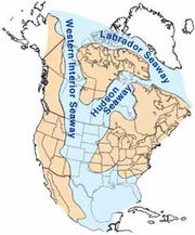
The region was taken over the by a deep sea, the Cretaceous Cretaceous The Cretaceous , derived from the Latin "creta" , usually abbreviated K for its German translation Kreide , is a geologic period and system from circa to million years ago. In the geologic timescale, the Cretaceous follows the Jurassic period and is followed by the Paleogene period of the... Western Interior Seaway Western Interior Seaway The Western Interior Seaway, also called the Cretaceous Seaway, the Niobraran Sea, and the North American Inland Sea, was a huge inland sea that split the continent of North America into two halves, Laramidia and Appalachia, during most of the mid- and late-Cretaceous Period... , and deposited mass amounts of shale over the area known as the Pierre Shale. Both the thick section of shale and the marine life fossils found (ammonite Ammonite Ammonite, as a zoological or paleontological term, refers to any member of the Ammonoidea an extinct subclass within the Molluscan class Cephalopoda which are more closely related to living coleoids Ammonite, as a zoological or paleontological term, refers to any member of the Ammonoidea an extinct... s and skeletons of fish and such marine reptiles as mosasaur Mosasaur Mosasaurs are large extinct marine lizards. The first fossil remains were discovered in a limestone quarry at Maastricht on the Meuse in 1764... s, plesiosaur Plesiosaur Plesiosauroidea is an extinct clade of carnivorous plesiosaur marine reptiles. Plesiosauroids, are known from the Jurassic and Cretaceous Periods... s, and extinct species of sea turtle Sea turtle Sea turtles are marine reptiles that inhabit all of the world's oceans except the Arctic.-Distribution:... s, along with rare dinosaur Dinosaur Dinosaurs are a diverse group of animals of the clade and superorder Dinosauria. They were the dominant terrestrial vertebrates for over 160 million years, from the late Triassic period until the end of the Cretaceous , when the Cretaceous–Paleogene extinction event led to the extinction of... and bird remains). Colorado eventually drained from being at the bottom of an ocean to land again, giving yield to another fossiliferous rock layer, the Denver Formation. At about 68 million years ago, the Front Range began to rise again due to the Laramide Orogeny in the west. |
 |
Garden of the Gods Garden of the Gods Garden of the Gods is a public park located in Colorado Springs, Colorado, USA.-Genesis of the park:Entrance to the park is free according to the wish of Charles Elliott Perkins, whose children donated the land to the city of Colorado Springs in 1909.... , Fountain Creek Nature Center, Rooney Road near Dinosaur Ridge Dinosaur Ridge Dinosaur Ridge is part of the Morrison Fossil Area National Natural Landmark located in Morrison, Colorado, just west of Denver.The Dinosaur Ridge area is one of the world's most famous dinosaur fossil localities. In 1877, some of the best-known dinosaurs were found here, including Apatosaurus,... , Valmont Dike |
| Fox Hills Formation Fox Hills Formation The Fox Hills Formation is a Cretaceous geologic formation in the northwestern Great Plains of North America. It is present from Alberta on the north to Colorado in the south.... |
Paleogene Paleogene The Paleogene is a geologic period and system that began 65.5 ± 0.3 and ended 23.03 ± 0.05 million years ago and comprises the first part of the Cenozoic Era... / Cretaceous Cretaceous The Cretaceous , derived from the Latin "creta" , usually abbreviated K for its German translation Kreide , is a geologic period and system from circa to million years ago. In the geologic timescale, the Cretaceous follows the Jurassic period and is followed by the Paleogene period of the... |
The Fox Hills Formation is a marginal marine yellow sandstone Sandstone Sandstone is a sedimentary rock composed mainly of sand-sized minerals or rock grains.Most sandstone is composed of quartz and/or feldspar because these are the most common minerals in the Earth's crust. Like sand, sandstone may be any colour, but the most common colours are tan, brown, yellow,... with shale Shale Shale is a fine-grained, clastic sedimentary rock composed of mud that is a mix of flakes of clay minerals and tiny fragments of other minerals, especially quartz and calcite. The ratio of clay to other minerals is variable. Shale is characterized by breaks along thin laminae or parallel layering... interbeds created with the receding Western Interior Seaway Western Interior Seaway The Western Interior Seaway, also called the Cretaceous Seaway, the Niobraran Sea, and the North American Inland Sea, was a huge inland sea that split the continent of North America into two halves, Laramidia and Appalachia, during most of the mid- and late-Cretaceous Period... in Late Cretacous time. |
 |
|
| Laramie Formation Laramie Formation The Laramie Formation is a geologic formation of Cretaceous age, named by Clarence King in 1876 for exposures in northeastern Colorado, in the United States.... |
Paleogene Paleogene The Paleogene is a geologic period and system that began 65.5 ± 0.3 and ended 23.03 ± 0.05 million years ago and comprises the first part of the Cenozoic Era... / Cretaceous Cretaceous The Cretaceous , derived from the Latin "creta" , usually abbreviated K for its German translation Kreide , is a geologic period and system from circa to million years ago. In the geologic timescale, the Cretaceous follows the Jurassic period and is followed by the Paleogene period of the... |
Laramie Formation is a geologic formation of Cretaceous Cretaceous The Cretaceous , derived from the Latin "creta" , usually abbreviated K for its German translation Kreide , is a geologic period and system from circa to million years ago. In the geologic timescale, the Cretaceous follows the Jurassic period and is followed by the Paleogene period of the... age, of the Denver Basin Denver Basin The Denver Basin, sometimes also called the Julesburg Basin, Denver-Julesburg Basin , or the D-J Basin, is a geologic structural basin centered in eastern Colorado in the United States, but extending into southeast Wyoming, western Nebraska, and western Kansas... and ranges from 400–500 feet on the western side of the basin and 200–300 feet thick on the eastern side. The formation can be divided into a lower unnamed member containing bedded sandstone Sandstone Sandstone is a sedimentary rock composed mainly of sand-sized minerals or rock grains.Most sandstone is composed of quartz and/or feldspar because these are the most common minerals in the Earth's crust. Like sand, sandstone may be any colour, but the most common colours are tan, brown, yellow,... , clay Clay Clay is a general term including many combinations of one or more clay minerals with traces of metal oxides and organic matter. Geologic clay deposits are mostly composed of phyllosilicate minerals containing variable amounts of water trapped in the mineral structure.- Formation :Clay minerals... , and coal Coal Coal is a combustible black or brownish-black sedimentary rock usually occurring in rock strata in layers or veins called coal beds or coal seams. The harder forms, such as anthracite coal, can be regarded as metamorphic rock because of later exposure to elevated temperature and pressure... and an upper unnamed member composed predominately of 90 to 190 m of drab-colored mudstone, some sandstone, and thin coal beds. |
||
| Denver Formation Denver Formation The Denver Formation is a geological formation in Colorado whose strata date back to the Late Cretaceous. Dinosaur remains are among the fossils that have been recovered from the formation.-Ornithischians:-Saurischians:-References:... |
Paleogene Paleogene The Paleogene is a geologic period and system that began 65.5 ± 0.3 and ended 23.03 ± 0.05 million years ago and comprises the first part of the Cenozoic Era... / Cretaceous Cretaceous The Cretaceous , derived from the Latin "creta" , usually abbreviated K for its German translation Kreide , is a geologic period and system from circa to million years ago. In the geologic timescale, the Cretaceous follows the Jurassic period and is followed by the Paleogene period of the... 55- million years |
The Denver Formation contained fossils and bones from dinosaurs like Tyrannosaurus rex Tyrannosaurus Tyrannosaurus meaning "tyrant," and sauros meaning "lizard") is a genus of coelurosaurian theropod dinosaur. The species Tyrannosaurus rex , commonly abbreviated to T. rex, is a fixture in popular culture. It lived throughout what is now western North America, with a much wider range than other... and Triceratops Triceratops Triceratops is a genus of herbivorous ceratopsid dinosaur which lived during the late Maastrichtian stage of the Late Cretaceous Period, around 68 to 65 million years ago in what is now North America. It was one of the last dinosaur genera to appear before the great Cretaceous–Paleogene... . While the forests of vegetation, dinosaurs, and other organisms thrived, their reign would come to an end at the K–T boundary K–T boundary The K–T boundary is a geological signature, usually a thin band, dated to 65.5 ± 0.3 Ma ago. K is the traditional abbreviation for the Cretaceous period, and T is the abbreviation for the Tertiary period... . In an instant, millions of species are obliterated from a meteor impact in Mexico's Yucatan Peninsula Yucatán Peninsula The Yucatán Peninsula, in southeastern Mexico, separates the Caribbean Sea from the Gulf of Mexico, with the northern coastline on the Yucatán Channel... . While this extinction lead to the dinosaurs' and other organisms' demise, some life did prevail to repopulate the earth as it recovered from this tremendous disaster. The uplifted Front Range continued to constantly erode and, by 40 million years ago, the range was once again buried in its own rubble. |
Austin Bluffs Park, Green Mountain, Palmer Park Palmer Park, Colorado Springs Palmer Park is a park in Colorado Springs, Colorado. Located at 3650 Maizeland Road, the park is several miles northeast of the downtown area, but centrally located in the suburban area.-History:... , Pulpit Rock Park, South Table Mountain South Table Mountain (Colorado) South Table Mountain is a mesa located just southeast of downtown Golden, Colorado in Jefferson County, Colorado. Its most distinctive feature is its cap of basalt rock formed from ancient lava flows. South Table Mountain is a popular scenic and recreational destination of the Denver metro area,... |
|
| Paleosol Paleosol In the geosciences, paleosol can have two meanings. The first meaning, common in geology and paleontology, refers to a former soil preserved by burial underneath either sediments or volcanic deposits , which in the case of older deposits have lithified into rock... - Dawson Arkose Arkose Arkose is a detrital sedimentary rock, specifically a type of sandstone containing at least 25% feldspar. Arkosic sand is sand that is similarly rich in feldspar, and thus the potential precursor of arkose.... |
Paleogene Paleogene The Paleogene is a geologic period and system that began 65.5 ± 0.3 and ended 23.03 ± 0.05 million years ago and comprises the first part of the Cenozoic Era... 37-55 million years |
Up to 20 foot thick, multi-colored layers of clay form in this prehistoric tropical forest. This layer, Paleosol, is a soil of fossils such as petrified wood. An uplift occurred on the Front Range that caused the Pikes Peak granite to become exposed and then erode on the surface, resulting into a white sandstone called Dawson Arkose. |  |
Castlewood Canyon State Park Castlewood Canyon State Park Castlewood Canyon State Park is a Colorado state park near Franktown, Colorado. The park protects a unique part of Colorado's history . Visitors can still see the remnants and damage from that dam which burst in 1933. The event sent a wave of water all the way to downtown Denver resulting in a flood... , Daniel's Park, Paint Mines Interpretive Park, Rock Park |
| Castle Rock Rhyolite Rhyolite This page is about a volcanic rock. For the ghost town see Rhyolite, Nevada, and for the satellite system, see Rhyolite/Aquacade.Rhyolite is an igneous, volcanic rock, of felsic composition . It may have any texture from glassy to aphanitic to porphyritic... |
Paleogene Paleogene The Paleogene is a geologic period and system that began 65.5 ± 0.3 and ended 23.03 ± 0.05 million years ago and comprises the first part of the Cenozoic Era... 34-37 million years ago |
37 million years ago, a great volcanic eruption took place in the Collegiate Range and covered the landscape in molten hot ash that instantly torched and consumed everything across the landscape. An entire lush environment was capped in a matter of minutes with 20 feet of extremely resistant rock, rhyolite Rhyolite This page is about a volcanic rock. For the ghost town see Rhyolite, Nevada, and for the satellite system, see Rhyolite/Aquacade.Rhyolite is an igneous, volcanic rock, of felsic composition . It may have any texture from glassy to aphanitic to porphyritic... . |
 |
Castlewood Canyon State Park Castlewood Canyon State Park Castlewood Canyon State Park is a Colorado state park near Franktown, Colorado. The park protects a unique part of Colorado's history . Visitors can still see the remnants and damage from that dam which burst in 1933. The event sent a wave of water all the way to downtown Denver resulting in a flood... , Molly Brown House Molly Brown House The Molly Brown House Museum is a house located at 1340 Pennsylvania Street in Denver, Colorado, United States that was the home of American philanthropist, socialite, and activist Margaret Brown. Brown was known as "The Unsinkable Molly Brown" because she survived the sinking of the RMS Titanic... Museum, Rocks Park and mesa tops between Castle Rock Castle Rock, Colorado The Town of Castle Rock is the county seat of Douglas County, Colorado, United States and is named for the prominent castle tower-shaped butte near the center of town. It is part of Colorado's Front Range Urban Corridor and is located roughly 28 miles south of Denver and 37 miles north of... and Monument Hill Monument Hill (Colorado) Monument Hill or Back Forest Divide Pass is a elevation mountain pass in the Palmer Divide in central Colorado in the United States. The pass dividing the Arkansas River drainage system to the south and the Platte River drainage system to the north is the high point on between Denver and Colorado... |
| Castle Rock Conglomerate Conglomerate (geology) A conglomerate is a rock consisting of individual clasts within a finer-grained matrix that have become cemented together. Conglomerates are sedimentary rocks consisting of rounded fragments and are thus differentiated from breccias, which consist of angular clasts... |
16,000 - 34 million years ago | However, as seen before, life rebounds, and after a few million years mass floods cut through the rhyolite and eroded much of it as plants and animals began to recolonize the landscape. The mass flooding and erosion of the volcanic rock gave way to the Castle Rock Conglomerate that can be found in the Front Range. About 10 million years ago, the Front Range began to rise up again and the resistant granite in the heart of the mountains thrust upwards and stood tall, while the weaker sediments deposited above it eroded away. | Castlewood Canyon State Park Castlewood Canyon State Park Castlewood Canyon State Park is a Colorado state park near Franktown, Colorado. The park protects a unique part of Colorado's history . Visitors can still see the remnants and damage from that dam which burst in 1933. The event sent a wave of water all the way to downtown Denver resulting in a flood... , Rocks Park |
|
| Ice Age Summer, Quarternary Sediments | 11,000-16,000 years ago | As the Front Range rose, streams and recent (16,000 years ago) glaciations during the Quaternary Quaternary The Quaternary Period is the most recent of the three periods of the Cenozoic Era in the geologic time scale of the ICS. It follows the Neogene Period, spanning 2.588 ± 0.005 million years ago to the present... age literally unburied the range by cutting through the weaker sediment, creating mesa tops and alluvial plains, and giving rise to the present Rocky Mountains. The receding glaciers and warming into an Ice Age summer created a climate suitable to camelops Camelops Camelops is an extinct genus of camels that once roamed western North America, where it disappeared at the end of the Pleistocene about 10,000 years ago. Its name is derived from the Greek κάμελος + , thus "camel-face."-Background:... , mastodon Mastodon Mastodons were large tusked mammal species of the extinct genus Mammut which inhabited Asia, Africa, Europe, North America and Central America from the Oligocene through Pleistocene, 33.9 mya to 11,000 years ago. The American mastodon is the most recent and best known species of the group... , mammoth Mammoth A mammoth is any species of the extinct genus Mammuthus. These proboscideans are members of Elephantidae, the family of elephants and mammoths, and close relatives of modern elephants. They were often equipped with long curved tusks and, in northern species, a covering of long hair... , bison antiquus Bison antiquus Bison antiquus, sometimes called the ancient bison, was the most common large herbivore of the North American continent for over ten thousand years, and is a direct ancestor of the living American bison.... and other megafauna Megafauna In terrestrial zoology, megafauna are "giant", "very large" or "large" animals. The most common thresholds used are or... . |
Carson Nature Center, Highlands Ranch Open Space, Sand Creek Drainage, South Platte Park | |
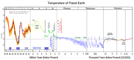
Paleoclimatology
PaleoclimatologyPaleoclimatology
Paleoclimatology is the study of changes in climate taken on the scale of the entire history of Earth. It uses a variety of proxy methods from the Earth and life sciences to obtain data previously preserved within rocks, sediments, ice sheets, tree rings, corals, shells and microfossils; it then...
is the study of prehistoric weather. The Eemian interglacial period spanned 130,000–114,000 BP. The Laurentide ice sheet
Laurentide ice sheet
The Laurentide Ice Sheet was a massive sheet of ice that covered hundreds of thousands of square miles, including most of Canada and a large portion of the northern United States, multiple times during Quaternary glacial epochs. It last covered most of northern North America between c. 95,000 and...
covered much of Canada and the northern United States from ca. 95,000 and ca. 20,000 years before present.
Ecosystems
The Denver Museum of Nature and Science
Denver Museum of Nature and Science
The Denver Museum of Nature & Science is a municipal natural history and science museum in Denver, Colorado. It is a resource for informal science education in the Rocky Mountain region. A variety of exhibitions, programs, and activities help museum visitors learn about the natural history of...
developed an eight-zone classification of ecosystems, defined primarily by the most present dominant plant life:
- GrasslandGrasslandGrasslands are areas where the vegetation is dominated by grasses and other herbaceous plants . However, sedge and rush families can also be found. Grasslands occur naturally on all continents except Antarctica...
s - Semidesert ShrublandShrublandShrubland, scrubland, scrub or brush is a plant community characterized by vegetation dominated by shrubs, often also including grasses, herbs, and geophytes. Shrubland may either occur naturally or be the result of human activity...
- Pinyon-Juniper Woodland (Pygmy forests)Pygmy forestA pygmy forest is a forest which, for pedological and geological reasons, contains only miniature trees. Pygmy forests may occur over various world locations with notable occurrences being noted in the literature of the: California coastal terraces and inner coastal mountains of Northern...
- RiparianRiparian zoneA riparian zone or riparian area is the interface between land and a river or stream. Riparian is also the proper nomenclature for one of the fifteen terrestrial biomes of the earth. Plant habitats and communities along the river margins and banks are called riparian vegetation, characterized by...
- Montane ShrublandMontane grasslands and shrublandsMontane grasslands and shrublands is a biome defined by the World Wildlife Fund. The biome includes high altitude grasslands and shrublands around the world....
- Montane ForestMontaneIn biogeography, montane is the highland area located below the subalpine zone. Montane regions generally have cooler temperatures and often have higher rainfall than the adjacent lowland regions, and are frequently home to distinct communities of plants and animals.The term "montane" means "of the...
- Subalpine Forest
- Treeline
- Alpine TundraAlpine tundraAlpine tundra is a natural region that does not contain trees because it is at high altitude. Alpine tundra is distinguished from arctic tundra, because alpine soils are generally better drained than arctic soils...
Since the Precambrian
Precambrian
The Precambrian is the name which describes the large span of time in Earth's history before the current Phanerozoic Eon, and is a Supereon divided into several eons of the geologic time scale...
eon, the land forms have lifted, receded and have been eroded; global temperature has vacillated from tropical to ice age, which significantly affected the number and type of ecosystems and what animal and plant life flourished during each geological period.
Paleo-Indian period
The period immediately preceding the first humans coming into Colorado was the Ice AgeIce age
An ice age or, more precisely, glacial age, is a generic geological period of long-term reduction in the temperature of the Earth's surface and atmosphere, resulting in the presence or expansion of continental ice sheets, polar ice sheets and alpine glaciers...
Summer starting about 16,000 years ago. For the next five thousand years the landscape would change dramatically and most of the large animals would become extinct. Receding and melting glaciers created the Plum and Monument Creeks, the Castle Rock mesas and unburied the Rocky Mountains
Rocky Mountains
The Rocky Mountains are a major mountain range in western North America. The Rocky Mountains stretch more than from the northernmost part of British Columbia, in western Canada, to New Mexico, in the southwestern United States...
. Large mammals, such as the mastodon
Mastodon
Mastodons were large tusked mammal species of the extinct genus Mammut which inhabited Asia, Africa, Europe, North America and Central America from the Oligocene through Pleistocene, 33.9 mya to 11,000 years ago. The American mastodon is the most recent and best known species of the group...
, mammoth
Mammoth
A mammoth is any species of the extinct genus Mammuthus. These proboscideans are members of Elephantidae, the family of elephants and mammoths, and close relatives of modern elephants. They were often equipped with long curved tusks and, in northern species, a covering of long hair...
, camels, giant sloths, cheetah
Cheetah
The cheetah is a large-sized feline inhabiting most of Africa and parts of the Middle East. The cheetah is the only extant member of the genus Acinonyx, most notable for modifications in the species' paws...
, bison antiquus
Bison antiquus
Bison antiquus, sometimes called the ancient bison, was the most common large herbivore of the North American continent for over ten thousand years, and is a direct ancestor of the living American bison....
and horses roamed the land.
Pre-Clovis culture
Pre-Clovis period is defined by Paleo-Indian hunting before the use of Clovis points. Lamb Spring
Lamb Spring
Lamb Spring is a pre-Clovis prehistoric Paleo-Indian archaeological site located in Littleton, Colorado with the largest collection of Columbian mammoth bones in the state. Lamb Spring also provides evidence of Paleo-Indian hunting in a later period by the Cody culture complex group...
in Littleton, with mammoth bones dated 14,140 to 12,140 years ago and hunting by use of stone tools other than Clovis points, is an example. Other examples include Dutton and Selby in the far eastern edge of Colorado.
Clovis culture
Clovis culture
The Clovis culture is a prehistoric Paleo-Indian culture that first appears 11,500 RCYBP , at the end of the last glacial period, characterized by the manufacture of "Clovis points" and distinctive bone and ivory tools...
There were a few Paleo-Indian cultures, distinctive by the size of the tools they used and the animals they hunted. People in the first, Clovis complex period, had large tools to hunt the megafauna
Megafauna
In terrestrial zoology, megafauna are "giant", "very large" or "large" animals. The most common thresholds used are or...
animals of the early Paleo-Indian period. There are a few pre-Clovis Paleo-Indian kill sites, before the use of Clovis points, Lamb Spring
Lamb Spring
Lamb Spring is a pre-Clovis prehistoric Paleo-Indian archaeological site located in Littleton, Colorado with the largest collection of Columbian mammoth bones in the state. Lamb Spring also provides evidence of Paleo-Indian hunting in a later period by the Cody culture complex group...
in Littleton, with mammoth bones dated 14,140 to 12,140 years ago, is an example. Other examples include Dutton and Selby in the far eastern edge of Colorado. A key Clovis culture
Clovis culture
The Clovis culture is a prehistoric Paleo-Indian culture that first appears 11,500 RCYBP , at the end of the last glacial period, characterized by the manufacture of "Clovis points" and distinctive bone and ivory tools...
site is the Dent Site
Dent Site
Dent Site is a Clovis culture site located in Weld County, Colorado, near Milliken, Colorado. It was the first site to provide evidence that man and mammoth co-existed in the Americas....
discovered in 1932 in Weld County
Weld County, Colorado
As of the census of 2000, there were 180,936 people, 63,247 households, and 45,221 families residing in the county. The population density was 45 people per square mile . There were 66,194 housing units at an average density of 17 per square mile...
, the first site to provide evidence that men and mammoth co-existed and that man hunted mammoth on the North American continent.
Folsom culture
Folsom tradition
The Folsom Complex is a name given by archaeologists to a specific Paleo-Indian archaeological culture that occupied much of central North America...
With time, the climate warmed again and lakes and savannas receded. The land became drier, food became less abundant, and as a result of the giant mammals became extinct. People adapted by hunting smaller mammals and gathering wild plants to supplement their diet. A new cultural complex was born, the Folsom tradition, with smaller projectile points to hunt smaller animals. Aside from hunting smaller mammals, people adapted by gathering wild plants to supplement their diet. Examples of the Folsom tradition in Colorado are the Lindenmeier Site
Lindenmeier Site
The Lindenmeier Site is a stratified multi-component archaeological site most famous for its Folsom component. It is located on the former Lindenmeier Ranch, now the Soapstone Prairie Natural Area, in northeastern Larimer County, Colorado, United States. The site contains the most extensive...
, Olsen-Chubbuck Bison Kill Site
Olsen-Chubbuck Bison Kill Site
The Olsen-Chubbuck Bison kill site is located southeast of Kit Carson, Colorado. The Paleo-Indian site dates back to an estimated 8000-6500 B.C. and provides evidence for bison hunting long before the use of the bow and arrow or horses. The site was named Olsen-Chubbuck after the amateur...
and Jones-Miller Bison Kill Site
Jones-Miller Bison Kill Site
The Jones-Miller Bison Kill Site, located in northeast Colorado, was a Paleo-Indian site where Bison antiquus were killed and butchered. Hell Gap complex bones and tools artifacts at the site are carbon dated from about ca. 8000-8050 BC.-Geography:...
s.
Plano cultures
Plano cultures
The Plano cultures is a name given by archaeologists to a group of disparate hunter-gatherer communities that occupied the Great Plains area of North America during the Paleo-Indian period in the United States and the Paleo-Indian or Archaic period in Canada....
Plano cultures existed from about 10,000 to 7,000 and are distinguished by their use of long, lanceolate and unfluted blades. Some of the best documented Plano sites are located in Colorado.
Cody complex
Cody complex
The Cody complex is a Paleo-Indian culture group first identified at a bison antiquus kill site near Cody, Wyoming in 1951.The tradition is generally attributed to the North American, primarily in the High Plains portion of the American Great Plains. The discovery of the Cody complex broadened the...
is a Plano culture that used unfluted projectile points and other tools like the Folsom and Clovis cultures from about 9,000 to 7,000 B.C. Olsen-Chubbuck Bison Kill Site
Olsen-Chubbuck Bison Kill Site
The Olsen-Chubbuck Bison kill site is located southeast of Kit Carson, Colorado. The Paleo-Indian site dates back to an estimated 8000-6500 B.C. and provides evidence for bison hunting long before the use of the bow and arrow or horses. The site was named Olsen-Chubbuck after the amateur...
, Jurgens Site
Jurgens Site
The Jurgens Site is an Paleo-Indian site located near Greeley in Weld County, Colorado. While the site was used primarily to hunt and butcher bison antiquus, there is evidence that the Paleo-Indians also gathered plants and seeds for food about 7,000 to 7,500 BC.-Geography:The site is located on a...
and Lamb Spring
Lamb Spring
Lamb Spring is a pre-Clovis prehistoric Paleo-Indian archaeological site located in Littleton, Colorado with the largest collection of Columbian mammoth bones in the state. Lamb Spring also provides evidence of Paleo-Indian hunting in a later period by the Cody culture complex group...
are Cody complex or culture sites.
Hell Gap complex
Hell Gap complex
Hell Gap complex is a Plano culture from 10,060 to 9,600 before present that is named after the archaeological site in Hell Gap, Wyoming. Hell Gap points are long stemmed, convex blades....
is a Plano culture
Plano cultures
The Plano cultures is a name given by archaeologists to a group of disparate hunter-gatherer communities that occupied the Great Plains area of North America during the Paleo-Indian period in the United States and the Paleo-Indian or Archaic period in Canada....
from 10,060 to 9,600 B.C., named for the Hell Gap, Wyoming archaeological site
Archaeological site
An archaeological site is a place in which evidence of past activity is preserved , and which has been, or may be, investigated using the discipline of archaeology and represents a part of the archaeological record.Beyond this, the definition and geographical extent of a 'site' can vary widely,...
. It is distinguished by its long stemmed, convex and unfluted Hell Gap points. Jones-Miller Bison Kill Site
Jones-Miller Bison Kill Site
The Jones-Miller Bison Kill Site, located in northeast Colorado, was a Paleo-Indian site where Bison antiquus were killed and butchered. Hell Gap complex bones and tools artifacts at the site are carbon dated from about ca. 8000-8050 BC.-Geography:...
is the only Hell Gap location in Colorado.
Other Paleo-Indian sites are Roxborough State Park Archaeological District
Roxborough State Park Archaeological District
Roxborough State Park Archaeological District is located in Douglas County, Colorado near the town of Waterton. Roxborough State Park, south of Denver, Colorado, is a Colorado State Park day park...
and, with artifacts from the Goshen / Plainview culture, Phillips-Williams Fork Reservoir Site
Phillips-Williams Fork Reservoir Site
The Phillips-Williams Fork Reservoir site is a Paleoindian site located on the shore of the Williams Fork Reservoir, about southeast of Kremmling at an elevation of 2400m in Grand County, Colorado, near the center of Middle Park....
.
Archaic period
People of the Archaic period were hunters of small game, such as deer, antelope and rabbits, and gatherers of wild plants. The people moved seasonally to hunting and gathering sites. Late in the Archaic period, about 200-500 A.D., corn was introduced into the diet and pottery-making became an occupation for storing and caring food.Archaic cultures:
- Apex complexApex complexApex complex is a Paleo-Indian cultural tradition of the Middle Archaic period. Apex complex artifacts, dated from about 3000 to 500 BC, first appeared in the Magic Mountain Site near Apex Creek. The Irwins, archaeologists at Magic Mountain, believe that the artifacts are from ancestors of...
Post-Archaic hunter-gatherer cultures
- Woodland period. The Woodland period, or Early Ceramic period, began in the Plains about AD 0 with the defining distinction of the creation of cordwrapped pottery, development of settlement areas, and use of smaller projectile points for hunting smaller game and/or bow and arrow technology.
- Sopris phase (AD 1000-1250). In the very southeastern area of Colorado, around the present town of Trinidad, was a culture that followed the Archaic period. Although the culture appeared to have been greatly influenced by pueblo people, such as the Taos PuebloTaos PuebloTaos Pueblo is an ancient pueblo belonging to a Taos speaking Native American tribe of Pueblo people. It is approximately 1000 years old and lies about north of the modern city of Taos, New Mexico, USA...
and trade in the Upper Rio Grande, the Sopris culture was generally a hunter-gathererHunter-gathererA hunter-gatherer or forage society is one in which most or all food is obtained from wild plants and animals, in contrast to agricultural societies which rely mainly on domesticated species. Hunting and gathering was the ancestral subsistence mode of Homo, and all modern humans were...
.
| Period | Structures | Pottery | Points and other |
|---|---|---|---|
| Initial 1000-1100 |
Pit-house Pit-house A pit-house is a dwelling dug into the ground which may also be layered with stone.These structures may be used as places to tell stories, dance, sing, celebrate, and store food. In archaeology, pit-houses are also termed sunken featured buildings and are found in numerous cultures around the world... , jacal Jacal The jacal is an adobe style housing structure historically found throughout parts of the south-western United States and Mexico. The structure was employed by some Native people of the Americas prior to European colonization and was later employed by both Hispanic and Anglo settlers in Texas and... structure and campsites. |
Taos gray and distinctly different Sopris plain pottery | Corner-notched points are popular, but not the only points. Basin metate Metate A metate is a mortar, a ground stone tool used for processing grain and seeds. In traditional Mesoamerican culture, metates were typically used by women who would grind calcified maize and other organic materials during food preparation... s. |
| Early 1100-1150 |
Adobe, combination adobe and jacal construction | Taos Taos Pueblo Taos Pueblo is an ancient pueblo belonging to a Taos speaking Native American tribe of Pueblo people. It is approximately 1000 years old and lies about north of the modern city of Taos, New Mexico, USA... gray, Sopris plain pottery, and the appearance of black on white, cordmarked, polished and incised pottery |
Trough metate Metate A metate is a mortar, a ground stone tool used for processing grain and seeds. In traditional Mesoamerican culture, metates were typically used by women who would grind calcified maize and other organic materials during food preparation... s, turquoise, beads of stone and shell. Maize is farmed a little. |
| Late 1150-1250 |
Sandstone slab masonry, with rounded corners and posts for support | There is an increase and predominance of Taos black on white and Taos gray incised pottery | Grooved mauls, slab metates |
- Panhandle culturePanhandle culturePanhandle culture is a prehistoric culture of the southern High Plains during the Middle Ceramic Period from AD 1200-1400. Panhandle sites are primarily in the panhandle and west central Oklahoma and the northern half of the Texas Panhandle....
(AD 1200-1400) is a prehistoric culture of the southern High Plains during the Middle Ceramic Period. Panhandle sites are primarily in the panhandleOklahoma PanhandleThe Oklahoma Panhandle is the extreme western region of the state of Oklahoma, comprising Cimarron County, Texas County, and Beaver County. Its name comes from the similarity of shape to the handle of a cooking pan....
and west central OklahomaOklahomaOklahoma is a state located in the South Central region of the United States of America. With an estimated 3,751,351 residents as of the 2010 census and a land area of 68,667 square miles , Oklahoma is the 28th most populous and 20th-largest state...
and the northern half of the Texas PanhandleTexas PanhandleThe Texas Panhandle is a region of the U.S. state of Texas consisting of the northernmost 26 counties in the state. The panhandle is a rectangular area bordered by New Mexico to the west and Oklahoma to the north and east...
. Antelope Creek focusAntelope Creek PhaseThe Antelope Creek Phase was an American Indian culture in the Texas Panhandle and adjacent Oklahoma dating from 1200 to 1450 AD. The two most important areas where the Antelope Creek people lived were in the Canadian River valley centered on present-day Lake Meredith near the city of Borger,...
is the primary, and to some the only, cultural tradition of the Panhandle culture. The Optima focus was defined for sites in west central Oklahoma, but after further study, these sites were defined as Antelope Creek focus. In 1975 Robert G. Campbell defined the Apishapa cultureApishapa cultureThe Apishapa culture, or Apishapa Phase, a prehistoric culture from A.D. 1000-1400, was named based upon an archaeological site in the Lower Apishapa canyon in Colorado. The Apishapa River, a tributary of the Arkansas River, formed the Apishapa canyon...
of southeastern Colorado's Chaquaqua Plateau as a Panhandle culture, which is disputed by other noted archaeologists. Most of the sites are centered around the Canadian RiverCanadian RiverThe Canadian River is the longest tributary of the Arkansas River. It is about long, starting in Colorado and traveling through New Mexico, the Texas Panhandle, and most of Oklahoma....
or it's tributaries, primarily Antelope Creek and also Cottonwood Creek, Dixon Creek, Tarbox Creek and also on the Archie King Ranch.
- Distinguishing characteristics of the Panhandle culture are:
- Great similarity to the Central PlainsGreat PlainsThe Great Plains are a broad expanse of flat land, much of it covered in prairie, steppe and grassland, which lies west of the Mississippi River and east of the Rocky Mountains in the United States and Canada. This area covers parts of the U.S...
complexes - Some, but much less, evidence of trading or influence of SouthwesternSouthwestern United StatesThe Southwestern United States is a region defined in different ways by different sources. Broad definitions include nearly a quarter of the United States, including Arizona, California, Colorado, Nevada, New Mexico, Oklahoma, Texas and Utah...
pueblo cultures - Single or multi-roomed stone structures
- Great similarity to the Central Plains
- The Apishapa PhaseApishapa cultureThe Apishapa culture, or Apishapa Phase, a prehistoric culture from A.D. 1000-1400, was named based upon an archaeological site in the Lower Apishapa canyon in Colorado. The Apishapa River, a tributary of the Arkansas River, formed the Apishapa canyon...
was identified by archaeologist Robert G. Campbell to be an outgrowth of the Graneros from the Texas panhandle. The Apishapa distinctions included that they sometimes lived in stone or slab constructed structures, made cord-wrapped pottery and used smaller projectile points; Unlike other Plains tribes, they did not use tools made of bison bones. They were a tradition of hunter gatherers who sometimes farmed. The people of the Apishapa phase lived in northern New Mexico or southern Colorado in rockshelters, single or multi-room stone or slab structures or in campsites, generally in protected areas near flowing water. Artifacts from this phase include a wide range of tools, cord-wrapped pottery and baskets. The initial reference point for the term was an archaeological site in the Lower Apishapa canyon.
Post-Archaic Basketmaker and Ancient Puebloan people
- Basketmakers (AD 1 to 550). The people living in the Four Corners region were introduced to maizeMaizeMaize known in many English-speaking countries as corn or mielie/mealie, is a grain domesticated by indigenous peoples in Mesoamerica in prehistoric times. The leafy stalk produces ears which contain seeds called kernels. Though technically a grain, maize kernels are used in cooking as a vegetable...
and basketryBasket weavingBasket weaving is the process of weaving unspun vegetable fibres into a basket or other similar form. People and artists who weave baskets are called basketmakers and basket weavers.Basketry is made from a variety of fibrous or pliable materials•anything that will bend and form a shape...
through MesoamericaMesoamericaMesoamerica is a region and culture area in the Americas, extending approximately from central Mexico to Belize, Guatemala, El Salvador, Honduras, Nicaragua, and Costa Rica, within which a number of pre-Columbian societies flourished before the Spanish colonization of the Americas in the 15th and...
n trading about 2,000 years ago. Able to have greater control of their diet through cultivation, the hunter-gatherers lifestyle became more sedentary as small disperse groups began cultivating maize and squash. They also continued to hunt and gather wild plants. They were named "Basketmakers" for their skill in making baskets for storing food, covering with pitch to heat water, and using to toast seeds and nuts. They wove bags, sandals, belts out of yucca plants and leaves - and strung beads. They occasionally lived in dry caves where they dug pits and lined with stones to store food. These people were ancestors of the pueblo people of the Hovenweep pueblo settlement and Mesa Verde.
- Modified Basketmakers (AD 550 to 750) introduced pottery which reduced the number of baskets that they made and eliminated the creation of woven bags. The simple, gray pottery allowed them a better tool for cooking and storage. Beans were added to the cultivated diet. Bows and arrows made hunting easier and thus the acquisition of hides for clothing. Turkey feathers were woven into blankets and robes. On the rim of Mesa Verde, small groups built pit houses which were built several feet below the surface with elements suggestive of the introduction of celebration rituals.
- Pueblo IPueblo I EraThe Pueblo I Era, from AD 750 to 900, was the first period in which Ancient Pueblo People began living in pueblo structures and realized an evolution in architecture, artistic expression, and water conservation...
(AD 750 to 900). Pueblo buildings were built with stone, wooden posts, and adobe. The buildings were located more closely together and reflected deepening religious celebration. Towers were built near kivas and likely used for look-outs. Pottery became more versatile, not just for cooking, but now included pitchers, ladles, bowls, jars and dishware for food and drink. White pottery with black designs emerged, the pigments coming from plants. Water management and conservation techniques, including the use of reservoirs and silt-retaining dams also emerged during this period.
- Pueblo IIPueblo II EraThe Pueblo II Era, AD 900 to 1150, was the second pueblo period of the Ancient Pueblo People of the Four Corners region of the American southwest. During this period people lived in dwellings made of stone and mortar, enjoyed communal activities in kivas, built towers and water conversing dams,...
(AD 900-1150). During the Pueblo II period there was an increase in population that resulted in creation of more than 10,000 sites in 150 years. Since much of the land was arid, the people supplemented their diet by hunting, foraging and trading pottery for food. By the end of the period, there were two-story dwellings made primarily of stone masonry, the presence of towers, and family and commuity kivas.
- Pueblo IIIPueblo III EraThe Pueblo III Era, AD 1150 to 1350, was the third period, also called the "Great Pueblo period" when Ancient Pueblo People lived in large cliff-dwelling, multi-storied pueblo, or cliff-side talus house communities...
(AD 1150-1300). Rohn and Ferguson, authors of Puebloan ruins of the Southwest, state that during the Pueblo III period there was a significant community change. Moving in from dispersed farmsteads into community centers at pueblos canyon heads or cliff dwellings on canyon shelves. Population peaked between 1200 to 1250 to more than 20,000 in the Mesa Verde region. By 1300 Ancient Pueblo People abandoned their settlements, as the result of climate changes and food shortage, and south to villages in Arizona and New Mexico.
Late prehistoric Native Americans
Ute Tribe
The Ute are an American Indian people now living primarily in Utah and Colorado. There are three Ute tribal reservations: Uintah-Ouray in northeastern Utah ; Southern Ute in Colorado ; and Ute Mountain which primarily lies in Colorado, but extends to Utah and New Mexico . The name of the state of...
and Navajo
Navajo people
The Navajo of the Southwestern United States are the largest single federally recognized tribe of the United States of America. The Navajo Nation has 300,048 enrolled tribal members. The Navajo Nation constitutes an independent governmental body which manages the Navajo Indian reservation in the...
, moved into the southwestern Colorado
Colorado
Colorado is a U.S. state that encompasses much of the Rocky Mountains as well as the northeastern portion of the Colorado Plateau and the western edge of the Great Plains...
and southeastern Utah
Utah
Utah is a state in the Western United States. It was the 45th state to join the Union, on January 4, 1896. Approximately 80% of Utah's 2,763,885 people live along the Wasatch Front, centering on Salt Lake City. This leaves vast expanses of the state nearly uninhabited, making the population the...
and came to inhabit the region.
- The ApacheApacheApache is the collective term for several culturally related groups of Native Americans in the United States originally from the Southwest United States. These indigenous peoples of North America speak a Southern Athabaskan language, which is related linguistically to the languages of Athabaskan...
presence in Colorado includes the Jicarilla ApacheJicarilla ApacheJicarilla Apache refers to the members of the Jicarilla Apache Nation currently living in New Mexico and speaking a Southern Athabaskan language...
and Dismal River cultureDismal River cultureThe Dismal River culture refers to a set of cultural attributes first seen in the Dismal River area of Nebraska in the 1930s by archaeologists William Duncan Strong, Waldo Rudolph Wedel and A. T. Hill...
s.
- The Jicarilla ApacheJicarilla ApacheJicarilla Apache refers to the members of the Jicarilla Apache Nation currently living in New Mexico and speaking a Southern Athabaskan language...
s are one of the Athabaskan linguisticAthabaskan languagesAthabaskan or Athabascan is a large group of indigenous peoples of North America, located in two main Southern and Northern groups in western North America, and of their language family...
groups that migrated out of CanadaCanadaCanada is a North American country consisting of ten provinces and three territories. Located in the northern part of the continent, it extends from the Atlantic Ocean in the east to the Pacific Ocean in the west, and northward into the Arctic Ocean...
, by 1525 CE, and lived in what they considered their land bounded by four sacred Rivers in northern New MexicoNew MexicoNew Mexico is a state located in the southwest and western regions of the United States. New Mexico is also usually considered one of the Mountain States. With a population density of 16 per square mile, New Mexico is the sixth-most sparsely inhabited U.S...
and southern ColoradoColoradoColorado is a U.S. state that encompasses much of the Rocky Mountains as well as the northeastern portion of the Colorado Plateau and the western edge of the Great Plains...
: the Rio GrandeRio GrandeThe Rio Grande is a river that flows from southwestern Colorado in the United States to the Gulf of Mexico. Along the way it forms part of the Mexico – United States border. Its length varies as its course changes...
, Pecos RiverPecos RiverThe headwaters of the Pecos River are located north of Pecos, New Mexico, United States, at an elevation of over 12,000 feet on the western slope of the Sangre de Cristo mountain range in Mora County. The river flows for through the eastern portion of that state and neighboring Texas before it...
, Arkansas RiverArkansas RiverThe Arkansas River is a major tributary of the Mississippi River. The Arkansas generally flows to the east and southeast as it traverses the U.S. states of Colorado, Kansas, Oklahoma, and Arkansas. The river's initial basin starts in the Western United States in Colorado, specifically the Arkansas...
, and the Canadian RiverCanadian RiverThe Canadian River is the longest tributary of the Arkansas River. It is about long, starting in Colorado and traveling through New Mexico, the Texas Panhandle, and most of Oklahoma....
containing sacred mountain peaks and ranges. They also ranged out into the plains of northwestern TexasTexasTexas is the second largest U.S. state by both area and population, and the largest state by area in the contiguous United States.The name, based on the Caddo word "Tejas" meaning "friends" or "allies", was applied by the Spanish to the Caddo themselves and to the region of their settlement in...
and the western portions of OklahomaOklahomaOklahoma is a state located in the South Central region of the United States of America. With an estimated 3,751,351 residents as of the 2010 census and a land area of 68,667 square miles , Oklahoma is the 28th most populous and 20th-largest state...
and KansasKansasKansas is a US state located in the Midwestern United States. It is named after the Kansas River which flows through it, which in turn was named after the Kansa Native American tribe, which inhabited the area. The tribe's name is often said to mean "people of the wind" or "people of the south...
. The Jicarilla Apache were hunter-gatherers, hunting primarily buffalo through the 17th century and thereafter added smaller game to their diet. Women gathered berries, agave, honey, onions, potatoes, nuts and seeds. Some bands practiced seasonal agricultureAgricultureAgriculture is the cultivation of animals, plants, fungi and other life forms for food, fiber, and other products used to sustain life. Agriculture was the key implement in the rise of sedentary human civilization, whereby farming of domesticated species created food surpluses that nurtured the...
along the upper Arkansas RiverArkansas RiverThe Arkansas River is a major tributary of the Mississippi River. The Arkansas generally flows to the east and southeast as it traverses the U.S. states of Colorado, Kansas, Oklahoma, and Arkansas. The river's initial basin starts in the Western United States in Colorado, specifically the Arkansas...
, cultivating squash, beans, pumpkins, melons, peas, wheat, and corn.- Arapaho
- Cheyenne
- ComancheComancheThe Comanche are a Native American ethnic group whose historic range consisted of present-day eastern New Mexico, southern Colorado, northeastern Arizona, southern Kansas, all of Oklahoma, and most of northwest Texas. Historically, the Comanches were hunter-gatherers, with a typical Plains Indian...
- Kiowa
- Navajo peopleNavajo peopleThe Navajo of the Southwestern United States are the largest single federally recognized tribe of the United States of America. The Navajo Nation has 300,048 enrolled tribal members. The Navajo Nation constitutes an independent governmental body which manages the Navajo Indian reservation in the...
- The ancestors to the Navajo were one of the tribes of the southern division of the AthabaskanAthabaskan languagesAthabaskan or Athabascan is a large group of indigenous peoples of North America, located in two main Southern and Northern groups in western North America, and of their language family...
linguistic family that migrated south from Alaska and northwestern Canada, most likely traveling through the Great BasinGreat BasinThe Great Basin is the largest area of contiguous endorheic watersheds in North America and is noted for its arid conditions and Basin and Range topography that varies from the North American low point at Badwater Basin to the highest point of the contiguous United States, less than away at the...
. The Navajo ancestors were in the area after AD 1300, but at least by the early 1500s. - Pawnee
- Shoshone
- Ute hunter-gathererHunter-gathererA hunter-gatherer or forage society is one in which most or all food is obtained from wild plants and animals, in contrast to agricultural societies which rely mainly on domesticated species. Hunting and gathering was the ancestral subsistence mode of Homo, and all modern humans were...
ancestors arrived in the area from California in about the 12th century into an area that ranged east to the Great Plains and in canyons and mountains of eastern Utah and Colorado.
- The Ute are the only Native American group with reservations in Colorado.
- Southern Ute Indian ReservationSouthern Ute Indian ReservationThe Southern Ute Indian Reservation lies in southwestern Colorado, USA, along the northern border of New Mexico. Its territory consists of land from three counties; in descending order of surface area they are La Plata, Archuleta, and Montezuma Counties. The reservation has a land area of 1,058.785...
- Ute Mountain Ute TribeUte Mountain Ute TribeThe Ute Mountain Ute Tribe is one of three federally recognized tribes of the Ute Nation, and are mostly descendants of the historic Weeminuche Band who moved to the Southern Ute reservation in 1897...
and Reservation
- Southern Ute Indian Reservation
See also
- Geology of the Rocky MountainsGeology of the Rocky MountainsThe geology of the Rocky Mountains is that of a discontinuous series of mountain ranges with distinct geological origins. Collectively these make up the Rocky Mountains, a mountain system that stretches from Canada through central New Mexico and which is part of the great mountain system known as...
- History of ColoradoHistory of ColoradoThe human history of Colorado extends back more than 13,000 years. The region that is today the state of Colorado was first inhabited by Native Americans...
- List of prehistoric sites in Colorado