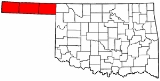
All Topics  
Oklahoma Panhandle


   Email Print
   Bookmark   Link


Oklahoma Panhandle


The Oklahoma Panhandle is the extreme western region of the state of Oklahoma
Oklahoma

Oklahoma is a U.S. state and a sovereignty located in the South Central United States and Southern United States of the United States of America ....
, comprising Cimarron County
Cimarron County, Oklahoma

Cimarron County is a county located in the U.S. state of Oklahoma. The 2000 census shows it has the least population of any county in Oklahoma....
, Texas County
Texas County, Oklahoma

Texas County is a county located in the U.S. state of Oklahoma. Texas County was formed at Oklahoma statehood from the central one-third of "Old Beaver County" also known as "No Man's Land"....
, and Beaver County
Beaver County, Oklahoma

Beaver County is a county located in the U.S. state of Oklahoma. As of 2000, the population is 5,857. Its county seat is Beaver, Oklahoma.The land where Beaver County is located has been under several jurisdictions....
. Its name comes from the similarity of shape to the handle
Panhandle

A panhandle or salient is an informal Political geography term for an elongated tail-like protrusion of a geo-political entity, such as an administrative division or a Sovereignty state that extends into another such entity as a peninsula extends into the water body....
 of a cooking pan.

Panhandle is bordered by Kansas and Colorado at 37°N
37th parallel north

The 37th parallel north is a circle of latitude that is 37 degree true north of the Earth equator.Starting at the Prime Meridian and heading eastwards, the parallel 37? north passes through:...
 on the north, New Mexico at 103°W
103rd meridian west

The meridian 103? west of Prime Meridian is a line of longitude that extends from the North Pole across the Arctic Ocean, North America, the Pacific Ocean, the Southern Ocean, and Antarctica to the South Pole....
 on the west, Texas at 36.5°N on the south, and the remainder of Oklahoma at 100°W
100th meridian west

The meridian 100? west of Prime Meridian is a line of longitude that extends from the North Pole across the Arctic Ocean, North America, the Pacific Ocean, the Southern Ocean, and Antarctica to the South Pole....
 on the east. The largest town in the region is Guymon
Guymon, Oklahoma

Guymon is a city in and the county seat of Texas County, Oklahoma, Oklahoma, United States. The population was 10,472 at the United States Census, 2000....
, which is the county seat
County seat

A county seat or parish seat is a term for an administrative center for a county or civil parish, primarily used in the United States. In the Northeast United States, the statutory term often is shire town, but colloquially county seat is the term in use there....
 of Texas County.


Discussion
Ask a question about 'Oklahoma Panhandle'
Start a new discussion about 'Oklahoma Panhandle'
Answer questions from other users
Full Discussion Forum


Encyclopedia


The Oklahoma Panhandle is the extreme western region of the state of Oklahoma
Oklahoma

Oklahoma is a U.S. state and a sovereignty located in the South Central United States and Southern United States of the United States of America ....
, comprising Cimarron County
Cimarron County, Oklahoma

Cimarron County is a county located in the U.S. state of Oklahoma. The 2000 census shows it has the least population of any county in Oklahoma....
, Texas County
Texas County, Oklahoma

Texas County is a county located in the U.S. state of Oklahoma. Texas County was formed at Oklahoma statehood from the central one-third of "Old Beaver County" also known as "No Man's Land"....
, and Beaver County
Beaver County, Oklahoma

Beaver County is a county located in the U.S. state of Oklahoma. As of 2000, the population is 5,857. Its county seat is Beaver, Oklahoma.The land where Beaver County is located has been under several jurisdictions....
. Its name comes from the similarity of shape to the handle
Panhandle

A panhandle or salient is an informal Political geography term for an elongated tail-like protrusion of a geo-political entity, such as an administrative division or a Sovereignty state that extends into another such entity as a peninsula extends into the water body....
 of a cooking pan.

Geography and economy

The Panhandle is bordered by Kansas and Colorado at 37°N
37th parallel north

The 37th parallel north is a circle of latitude that is 37 degree true north of the Earth equator.Starting at the Prime Meridian and heading eastwards, the parallel 37? north passes through:...
 on the north, New Mexico at 103°W
103rd meridian west

The meridian 103? west of Prime Meridian is a line of longitude that extends from the North Pole across the Arctic Ocean, North America, the Pacific Ocean, the Southern Ocean, and Antarctica to the South Pole....
 on the west, Texas at 36.5°N on the south, and the remainder of Oklahoma at 100°W
100th meridian west

The meridian 100? west of Prime Meridian is a line of longitude that extends from the North Pole across the Arctic Ocean, North America, the Pacific Ocean, the Southern Ocean, and Antarctica to the South Pole....
 on the east. The largest town in the region is Guymon
Guymon, Oklahoma

Guymon is a city in and the county seat of Texas County, Oklahoma, Oklahoma, United States. The population was 10,472 at the United States Census, 2000....
, which is the county seat
County seat

A county seat or parish seat is a term for an administrative center for a county or civil parish, primarily used in the United States. In the Northeast United States, the statutory term often is shire town, but colloquially county seat is the term in use there....
 of Texas County. Black Mesa
Black Mesa Mountain

Black Mesa extends from Mesa de Maya in Colorado southeasterly along the north bank of the Cimarron River, crossing the northeast corner of New Mexico to end at the confluence of the Cimarron and Carrizo Creek near Kenton, Oklahoma in the Oklahoma panhandle....
, the highest point in Oklahoma, is located in Cimarron County. The Panhandle occupies nearly all of the true High Plains
High Plains (United States)

The High Plains are a subregion of the Great Plains in the central United States, generally encompassing the western part of the Great Plains before the region reaches the Rocky Mountains....
 within the state of Oklahoma, being the only part of the state lying west of the 100th Meridian
100th meridian west

The meridian 100? west of Prime Meridian is a line of longitude that extends from the North Pole across the Arctic Ocean, North America, the Pacific Ocean, the Southern Ocean, and Antarctica to the South Pole....
, which generally marks the westernmost extent of moist air from the Gulf of Mexico
Gulf of Mexico

The Gulf of Mexico is the ninth largest body of water in the world. Considered a smaller part of the Atlantic Ocean, it is an oceanic basin largely surrounded by the North American continent and the island of Cuba....
. The North Canadian River
North Canadian River

North Canadian River is a river that flows through New Mexico, Texas and Oklahoma in the United States. The North Canadian River rises just east of Des Moines, New Mexico in Union County, New Mexico; it is known as Corrumpta Creek....
 is named Beaver River or Beaver Creek on its course through the Panhandle. Its land area is 14,728.12 km² (5,686.56 sq mi), which is larger than that of the state of Connecticut
Connecticut

Connecticut is a U.S. state located in the New England region of the northeastern United States. The state borders New York to the west and south , Massachusetts to the north, and Rhode Island to the east....
, and comprises 8.28 percent of Oklahoma's land area. At the 2000 census
United States Census, 2000

File:US-Census-2000Logo.svgThe Twenty-Second United States Census, known as Census 2000 and conducted by the United States Census Bureau, determined the resident population of the United States on April 1, 2000, to be 281,421,906, an increase of 13.2% over the 248,709,873 persons Enumeration during the United States Census, 1990....
 its population was 29,112 residents, or only 0.844 percent of the state's total.

Economy

The Panhandle is rather thinly populated (when compared to the rest of Oklahoma) making the labor force
Labor force

In economics, the people in the labor force are the suppliers of labor. The labor force is all the nonmilitary people who are employed or unemployed....
 in this region very small. Farming and ranch
Ranch

A ranch is an area of landscape, including various structures, given primarily to the practice of ranching, the practice of raising grazing livestock such as cattle or sheep for meat or wool....
ing operations occupy most of the economic activity in the region, with ranching dominating the drier western end. The region's higher education
Higher education

Higher education refers to a level of education that is provided by university, vocational university, community colleges, liberal arts colleges, Institute of technology and other collegiate level institutions, such as Vocational school, trade schools and career colleges, that award academic degrees or professional certifications....
al needs are served by Oklahoma Panhandle State University
Oklahoma Panhandle State University

Oklahoma Panhandle State University is a university in Goodwell, Oklahoma. OPSU is a baccalaureate degree granting institution. General governance of the institution is provided by the Board of Regents of the Oklahoma Agricultural and Mechanical Colleges....
, which is located in Goodwell, Oklahoma
Goodwell, Oklahoma

Goodwell is a town in Texas County, Oklahoma, Oklahoma, United States. The population was 1,192 at the United States Census, 2000.Goodwell is the home of Oklahoma Panhandle State University, established in 1909....
, 10 miles southwest of Guymon
Guymon, Oklahoma

Guymon is a city in and the county seat of Texas County, Oklahoma, Oklahoma, United States. The population was 10,472 at the United States Census, 2000....
, the Panhandle's largest city.

Major communities

  • Beaver
    Beaver, Oklahoma

    Beaver is a town in and the county seat of Beaver County, Oklahoma, Oklahoma, United States. The population was 1,570 at the United States Census, 2000, at which time it was a city; the city became a town in November 2005....
     (County Seat of Beaver County
    Beaver County, Oklahoma

    Beaver County is a county located in the U.S. state of Oklahoma. As of 2000, the population is 5,857. Its county seat is Beaver, Oklahoma.The land where Beaver County is located has been under several jurisdictions....
    )
  • Boise City
    Boise City, Oklahoma

    Boise City is a city in and the county seat of Cimarron County, Oklahoma, Oklahoma, United States. The population was 1,483 at the United States Census, 2000....
     (County Seat of Cimarron County
    Cimarron County, Oklahoma

    Cimarron County is a county located in the U.S. state of Oklahoma. The 2000 census shows it has the least population of any county in Oklahoma....
    )
  • Goodwell
    Goodwell, Oklahoma

    Goodwell is a town in Texas County, Oklahoma, Oklahoma, United States. The population was 1,192 at the United States Census, 2000.Goodwell is the home of Oklahoma Panhandle State University, established in 1909....
     (Home to Panhandle State University)
  • Guymon
    Guymon, Oklahoma

    Guymon is a city in and the county seat of Texas County, Oklahoma, Oklahoma, United States. The population was 10,472 at the United States Census, 2000....
     (County Seat of Texas County
    Texas County, Oklahoma

    Texas County is a county located in the U.S. state of Oklahoma. Texas County was formed at Oklahoma statehood from the central one-third of "Old Beaver County" also known as "No Man's Land"....
     and largest city in the Oklahoma Panhandle)
  • Hooker
    Hooker, Oklahoma

    Hooker is a city in Texas County, Oklahoma, Oklahoma, in the United States. As of the United States Census, 2000, the city population was 1,788....
  • Texhoma
    Texhoma, Oklahoma

    Texhoma is a town in Texas County, Oklahoma, Oklahoma, United States. The population was 935 at the United States Census, 2000. Founded around the Rock Island Railroad laying tracks through the area, much of the town's local economy is from ranching and livestock....


Other communities

  • Adams
    Adams, Oklahoma

    Adams is a rural unincorporated community located in Texas County, Oklahoma. The post office opened June 14, 1930. The ZIP Code is 73901. The community was named for Jesse L....
  • Balko
    Balko, Oklahoma

    Balko is a small unincorporated area in Beaver County, Oklahoma, Oklahoma, United States. The post office was established March 14, 1904. The population is around 623....
  • Felt
    Felt, Oklahoma

    Felt is a small unincorporated area in Cimarron County, Oklahoma, Oklahoma, United States. It was named for C.F.W. Felt of the Santa Fe Railroad....
  • Forgan
    Forgan, Oklahoma

    Forgan is a town in Beaver County, Oklahoma, Oklahoma, United States. The population was 532 at the United States Census, 2000.Geography...
  • Gate
    Gate, Oklahoma

    Gate is a town in Beaver County, Oklahoma, Oklahoma, United States. The population was 112 at the United States Census, 2000....
  • Hardesty
    Hardesty, Oklahoma

    Hardesty is a town in Texas County, Oklahoma, Oklahoma, in the United States. As of the United States Census, 2000, the town population was 277....
  • Kenton
    Kenton, Oklahoma

    Kenton is a small unincorporated area in Cimarron County, Oklahoma, Oklahoma, United States. There is a store, "The Merc", two bed and breakfasts, three church congregations, and a post office, which was established May 12 1891....
  • Keyes
    Keyes, Oklahoma

    Keyes is a town in Cimarron County, Oklahoma, Oklahoma, United States. The population was 410 at the United States Census, 2000.Geography...
  • Knowles
    Knowles, Oklahoma

    Knowles is a town in Beaver County, Oklahoma, Oklahoma, United States. The population was 32 at the United States Census, 2000.Geography...
  • Optima
    Optima, Oklahoma

    Optima is a town in Texas County, Oklahoma, Oklahoma, United States. The population was 266 at the United States Census, 2000....
  • Turpin
    Turpin, Oklahoma

    Turpin is a small unincorporated area in Beaver County, Oklahoma, Oklahoma, United States. The post office was established April 8, 1925. The Turpin Grain Elevator is on the National Register of Historic Places....
  • Tyrone
    Tyrone, Oklahoma

    Tyrone is a town in Texas County, Oklahoma, Oklahoma, United States. The population was 880 at the United States Census, 2000....


Points of interest

  • Black Mesa
    Black Mesa

    Black Mesa may refer to:Places in the United States:* Black Mesa , in Colorado, New Mexico, and the highest point in Oklahoma* Black Mesa Test Range, a United States Army rocket testing facility...
     State Park (Hiking trail to the top of Oklahoma's highest point)
  • Beaver Dunes State Park (Massive sand dunes along the Beaver River provide ATV adventures)
  • Optima Lake
    Optima Lake

    Optima Lake is an artificial lake in Texas County, Oklahoma. The lake is located near the towns of Hardesty, Oklahoma and Guymon, Oklahoma in the Oklahoma Panhandle....
     (Home to the Optima National Wildlife Refuge)


History

Okterritory
During its early history, the area contained no permanent settlements. With the arrival of horse
Horse

The horse is a hoofed mammal, a subspecies of one of seven extant species of the family Equidae. The horse has evolution of the horse over the past 45 to 55 million years from a small multi-toed creature into the large, odd-toed ungulate animal of today....
s from Spain
Spain

Spain or the Kingdom of Spain , is a country located in Southern Europe on the Iberian Peninsula.The Spanish constitution does not establish any official denomination of the country, even though Espa?a , Estado espa?ol and Naci?n espa?ola are used interchangeably....
 in the 16th century, nomadic Indian tribes were able to increase their use of the area for hunting, and for traveling from summer to winter quarters.

The non-Native American history of the panhandle traces its origins being part of the Spanish
Spanish Empire

The Spanish Empire was one of the largest empires in world history, and one of the first global empires. It included territories and colonies ruled by Spain in Europe, the Americas, Africa, Asia and Oceania between the 15th and late 19th centuries....
 New Spain
New Spain

The Viceroyalty of New Spain , was the political unit of Spain territories in North America and Asia-Pacific. The territory included the present-day Southwestern United States, Central America, the Caribbean, and the Philippines....
 empire. The Transcontinental Treaty (Adams-Onís Treaty
Adams-Onís Treaty

The Adams-On?s Treaty of 1819, also known as the Transcontinental Treaty of 1819, settled a border dispute in North America between the United States and Spain....
)
of 1819 between Spain and the United States set the western boundary of this portion of the Louisiana Purchase at the 100th meridian
Meridian (geography)

A meridian is an imaginary arc on the Earth's surface from the North Pole to the South Pole that connects all locations running along it with a given longitude....
. With Mexican independence in 1821, these lands became part of Mexico
Mexico

The United Mexican States , commonly known as Mexico , is a federalism constitutionalism republic in North America. It is bordered on the north by the United States; on the south and west by the Pacific Ocean; on the southeast by Guatemala, Belize, and the Caribbean Sea; and on the east by the Gulf of Mexico....
. With the formation of the Texas Republic
Republic of Texas

The Republic of Texas was a sovereignty nation in North America between the United States and Mexico that existed from 1836 to 1846.Formed as a break-away republic from Mexico by the Texas Revolution, the nation claimed borders that encompassed an area that included all of the present U.S....
, they became part of Texas. When Texas
Texas

Texas is a U.S. state located in the South Central United States, nicknamed the Lone Star State. Texas is the second largest U.S. state in both area and population, spanning , and with a growing population of 24.3 million residents....
 joined the U.S. in 1846, the strip became part of the United States.

The Cimarron Cut-Off for the Santa Fe Trail
Santa Fe Trail

The Santa Fe Trail was a 19th century transportation route through southwestern North America that connected Missouri with Santa Fe, New Mexico....
 passed through the area soon after the trade route was established in 1826 between the Spanish in Santa Fe
Santa Fe, New Mexico

Santa Fe is the Capital of the U.S. state of New Mexico. It is the List of cities in New Mexico and is the county seat of . Santa Fe had a population of 62,203 at the United States Census, 2000; the estimate for July 1, 2006, is 72,056....
 and the Americans in St. Louis
St. Louis, Missouri

St. Louis is an independent city in the U.S. state of Missouri, located near the confluence of the Mississippi River and the Missouri River. St....
. Travel along the route increased considerably after 1849 with the discovery of gold
California Gold Rush

The California Gold Rush began on January 24, 1848, when gold was discovered by James W. Marshall at Sutter's Mill, in Coloma, California, California....
 in California
California

California is a U.S. state on the West Coast of the United States of the United States, along the Pacific Ocean. It is bordered by Oregon to the north, Nevada to the east, Arizona to the southeast, and to the south the Mexico state of Baja California....
. The Cutoff passed through what is now Boise City, Oklahoma
Boise City, Oklahoma

Boise City is a city in and the county seat of Cimarron County, Oklahoma, Oklahoma, United States. The population was 1,483 at the United States Census, 2000....
 and on to Clayton, New Mexico
Clayton, New Mexico

Clayton is a town in Union County, New Mexico, New Mexico, United States. The population was 2,524 at the 2000 United States Census. It is the county seat of Union County, New Mexico....
 before continuing toward Santa Fe
Santa Fe, New Mexico

Santa Fe is the Capital of the U.S. state of New Mexico. It is the List of cities in New Mexico and is the county seat of . Santa Fe had a population of 62,203 at the United States Census, 2000; the estimate for July 1, 2006, is 72,056....
.

When Texas sought to enter the Union in 1845 as a slave state
Slave state

A slave state was a U.S. state in which slavery of African Americans was legal. Slavery was one of the Origins of the American Civil War of the American Civil War and was abolished by the Thirteenth Amendment of the United States Constitution in 1865....
, federal law in the United States based on the Missouri Compromise
Missouri Compromise

The Missouri Compromise was an agreement passed in 1820 between the slave state and free state factions in the United States Congress, involving primarily the regulation of slavery in the Historic regions of the United States....
 prohibited slavery North of 36°30' parallel north. Under the Compromise of 1850
Compromise of 1850

The Compromise of 1850 was a series of bills aimed at resolving the territorial and slavery controversies arising from the Mexican-American War ....
, Texas surrendered its lands north of 36°30' latitude. The 170-mile strip of land was thus left with no formal territorial ownership. It was officially called the "Public Land Strip" and was more commonly referred to as "No Man's Land."

The Compromise of 1850 also established the eastern boundary of New Mexico Territory
New Mexico Territory

The Territory of New Mexico became an organized territory of the United States on September 9, 1850, and it existed until New Mexico became the 47th U.S....
 at the 103rd meridian, thus setting the western boundary of the strip. The Kansas-Nebraska Act
Kansas-Nebraska Act

The Kansas-Nebraska Act of 1854 created the territories of Kansas Territory and Nebraska Territory, opened new lands, repealed the Missouri Compromise of 1820, and allowed settlers in those territories to determine if they would allow slavery within their boundaries....
 of 1854 set the southern border of Kansas Territory
Kansas Territory

The Territory of Kansas was an organized territory of the United States that existed from May 30, 1854, until January 29, 1861, when Kansas became the 34th U.S....
 as the 37th parallel
Circle of latitude

A circle of latitude, on the Earth, is an imaginary east-west circle connecting all locations that share a given latitude. A location's position along a circle of latitude is given by its longitude....
. This became the northern boundary of No Man's Land. When Kansas
Kansas

The State of Kansas is a Midwestern U.S. state in the Central United States of the United States of America, an area often referred to as the United States "Heartland"....
 joined the Union in 1861, the western part of Kansas Territory was assigned to Colorado Territory
Colorado Territory

The Territory of Colorado was an organized territory of the United States of America that existed from 28 Feb 1861, to 1 Aug 1876. The boundaries of the territory were identical with those of the current State of Colorado....
, but did not change the boundary.

Cimarron Territory

After the Civil War
American Civil War

The American Civil War , also known as the War Between the States and several Naming the American Civil War, was a civil war in the United States....
, cattlemen moved into the area. Gradually they organized themselves into ranches and established their own rules for arranging their land and adjudicating their disputes. There was still confusion over the status of the strip and some attempts were made to arrange rent with the Cherokee
Cherokee

The Cherokee are a Native Americans in the United States people orginally from the Southeastern United States . They are linguistically connected to speakers of the Iroquoian language....
s, despite the fact that the Outlet
Cherokee Outlet

The Cherokee Outlet, more often referred to as the Cherokee Strip, was located in what is now the state of Oklahoma, in the United States....
 ended at the 100th meridian. However, in 1886, Interior Secretary
United States Secretary of the Interior

The United States Secretary of the Interior is the head of the United States Department of the Interior.The US Department of the Interior should not be confused with the concept of Interior Ministry as used in other countries....
 L. Q. C. Lamar
Lucius Quintus Cincinnatus Lamar (II)

Lucius Quintus Cincinnatus Lamar was an United States politician and jurist from Mississippi. A United States Representative and United States Senate, he also served as United States Secretary of the Interior in the first administration of President Grover Cleveland, as well as an Associate Justice of the U.S....
, declared the area to be Public domain
Public domain (land)

Public domain is a term used to describe lands that were not under private or state ownership during the 18th and 19th centuries in the United States, as the country was expanding....
.

The strip was not yet surveyed
Public Land Survey System

File:US-DOI-BLM-logo.pngThe Public Land Survey System is a method used in the United States to survey and identify land parcels, particularly for titles and deeds of rural, wild or undeveloped land....
, and as that was one of the requirements of the Homestead Act
Homestead Act

Homestead Act was a United States Federal law that gave an applicant freehold title to 160 acres -640 acres of undeveloped land outside of the original 13 colonies....
 of 1862, the land could not be officially settled. Settlers by the thousands flooded in to assert their "squatter's rights" anyway. They surveyed their own land and by September had organized a self-governing and self-policing jurisdiction which they named the Cimarron Territory. A bill was introduced to Congress
United States Congress

The United States Congress is the Bicameralism legislature of the Federal government of the United States of the United States of America, consisting of two houses, the United States Senate and the United States House of Representatives....
 that same year to officially recognize the territory, but it failed to pass.

The organization of Cimarron Territory began soon after L.Q.C. Lamar
Lucius Quintus Cincinnatus Lamar (II)

Lucius Quintus Cincinnatus Lamar was an United States politician and jurist from Mississippi. A United States Representative and United States Senate, he also served as United States Secretary of the Interior in the first administration of President Grover Cleveland, as well as an Associate Justice of the U.S....
, U.S. Secretary of the Interior, in 1886, declared the area open to settlement by squatters. The area's only order was maintained by the vigilance committee
Vigilance committee

A vigilance committee, in the 19th century United States, was a group of private citizens who organized themselves for self-protection. The committees were established in areas where there was no local law enforcement, or where the local government was ineffectual, corrupt, or unpopular....
s provided by the cattlemen, and the thousands of new settlers recognized the need for a broader government.

The settlers soon formed their own vigilance committees, which organized a board charged with forming a territorial government. The board enacted a preliminary code of law and divided the strip into three districts divided by the meridians. They also called for a general election to choose three members from each district to meet on March 4, 1887, to form the government.

The elected council met as planned, elected Owen G. Chase as president, and named a full cabinet. They also enacted further laws and divided the strip into five counties (Benton, Beaver, Palo Duro, Optima, and Sunset), three senatorial districts (with three members from each district), and seven delegate districts (with two members from each district). The members from these districts were to be the legislative body
Legislature

Legislature is a type of representative deliberative assembly with the power to create and change laws. The law created by a legislature is called legislation or statutory law....
 for the proposed territory. Elections were held November 8, 1887, and the legislature met for the first time on December 5, 1887.

After the meeting in March, Owen G. Chase went to Washington, D.C.
Washington, D.C.

Washington, D.C. , formally the District of Columbia and commonly referred to as Washington, the District, or simply D.C., is the Capital of the United States, founded on July 16, 1790....
 to lobby for admission to Congress
United States Congress

The United States Congress is the Bicameralism legislature of the Federal government of the United States of the United States of America, consisting of two houses, the United States Senate and the United States House of Representatives....
 as the delegate from the new territory. A group disputing the Chase organization met, and elected and sent its own delegate to Washington. A bill was introduced to accept Chase but was never brought to a vote. Neither delegation was able to persuade Congress to accept the new territory. Another delegation went in 1888 but did no better.

In 1889, the Unassigned Lands
Unassigned Lands

Unassigned Lands, or Oklahoma, were in the center of the lands ceded to the United States by the Creek and Seminole Indians following the American Civil War and on which no other tribes had been settled....
 were opened for settlement and many of the residents went there. The population, generously estimated at 10,000, fell to about 3,000. The passage of the Organic Act in 1890 assigned No Man's Land to the new Oklahoma Territory
Oklahoma Territory

Oklahoma Territory was an organized territory of the United States from May 2, 1890 until November 16, 1907, when Oklahoma became the 46th U.S....
, and ended the short-lived Cimarron Territory.

Settlement and assimilation

In 1891, the government completed the survey and the remaining squatters were finally able to secure their homesteads under the Homestead Act.

No Man's Land became Seventh County, later renamed Beaver County. When Oklahoma Territory and Indian Territory joined the Union in 1907 as the single state of Oklahoma, Beaver County was divided into the present Beaver
Beaver County, Oklahoma

Beaver County is a county located in the U.S. state of Oklahoma. As of 2000, the population is 5,857. Its county seat is Beaver, Oklahoma.The land where Beaver County is located has been under several jurisdictions....
, Texas
Texas County, Oklahoma

Texas County is a county located in the U.S. state of Oklahoma. Texas County was formed at Oklahoma statehood from the central one-third of "Old Beaver County" also known as "No Man's Land"....
, and Cimarron
Cimarron County, Oklahoma

Cimarron County is a county located in the U.S. state of Oklahoma. The 2000 census shows it has the least population of any county in Oklahoma....
 counties.

Following the U.S. Census of 2000, the three counties of the panhandle were assigned to Oklahoma Congressional District 3
Oklahoma Congressional Districts

As of the United States 2000 Census, there are five Oklahoma United States congressional districts. Previous to the 2000 Census, Oklahoma had 6 Congressional districts....
, which, geographically speaking, is Oklahoma's largest Congressional district
Congressional district

A congressional Electoral district is an electoral constituency that elects a single member of a congress. Countries with congressional districts include the United States, the Philippines, and Japan....
.

Politics

The Oklahoma Panhandle is one of the most universally Republican areas of the nation. In the 2008 U.S. Presidential election
United States presidential election, 2008

The United States presidential election of 2008 was held on Tuesday, November 4, 2008. It was the 56th consecutive wikt:quadrennial United States United States presidential election....
, the three counties gave a weighted average of 87.5% of their votes to John McCain
John McCain

John Sidney McCain III is the senior senator United States United States Senator from Arizona. He was the Republican Party presidential nominee in the 2008 United States presidential election....
 and 12.5% to Barack Obama
Barack Obama

Barack Hussein Obama II is the List of Presidents of the United States and current President of the United States. He is the first African American to hold the office....
, with McCain carrying the state over Obama 65.6% to 34.4%.

In popular culture

  • Edna Ferber
    Edna Ferber

    Edna Ferber , was an American novelist, author and playwright....
     wrote a novel called Cimarron
    Cimarron

    Cimarron is the title of a novel published by popular historical fiction author Edna Ferber in 1929 in literature. The book was adapted into a critically acclaimed Cimarron in 1931 in film through RKO Pictures....
    , which was published in 1929.
  • A 1931 RKO Radio Pictures film version of Ferber's novel, Cimarron
    Cimarron (1931 film)

    Cimarron is a film directed by Wesley Ruggles and based on the Edna Ferber novel Cimarron, which won the Academy Award for Best Picture in 1931 in film....
     won the Academy Award for Best Picture
    Academy Award for Best Picture

    The Academy Award for Best Motion Picture is one of the Academy Award presented annually by the Academy of Motion Picture Arts and Sciences to artists working in the film industry....
    .
  • The 1931 picture was remade in 1960 by MGM, Cimarron
    Cimarron (1960 film)

    Cimarron is a 1960 in film western film based on the Edna Ferber novel Cimarron, featuring Glenn Ford and Maria Schell. It was directed by Anthony Mann, known for his westerns and film noirs....
     directed by Anthony Mann
    Anthony Mann

    Anthony Mann was an United States actor and film director....
    .
  • Cimarron Strip
    Cimarron Strip

    Cimarron Strip was a lavish weekly 90-minute United States Western Television program starring Stuart Whitman as Marshal Jim Crown. Produced by the creators of Gunsmoke and almost certainly the most violent TV western of its time, the series was written for adults....
     was a United States television series
    Television in the United States

    Television is one of the media of the United States of the United States. In an expansive country of Demography of the United States, television programs are some of the few things that nearly all Americans can share....
     based loosely on the Cimarron Territory. It was produced by CBS
    CBS

    CBS Broadcasting Inc. is an American radio network and television network. The name is derived from the initials of Columbia Broadcasting System, its former legal name....
    , running only one season (23 episodes), debuting on September 7, 1967 and ending on September 19, 1968.
  • Spirit: Stallion of the Cimarron
    Spirit: Stallion of the Cimarron

    Spirit: Stallion of the Cimarron is a 2002 Animation film that was released by DreamWorks Pictures. It follows the adventures of a young stallion who is nameless until the end of the movie....
     is an animated film, released in 2002, and set in the region during the post-Civil War
    American Civil War

    The American Civil War , also known as the War Between the States and several Naming the American Civil War, was a civil war in the United States....
     era.


See also

Geography:
  • Oklahoma
    Oklahoma

    Oklahoma is a U.S. state and a sovereignty located in the South Central United States and Southern United States of the United States of America ....
  • Cimarron County
    Cimarron County, Oklahoma

    Cimarron County is a county located in the U.S. state of Oklahoma. The 2000 census shows it has the least population of any county in Oklahoma....
  • Texas County
    Texas County, Oklahoma

    Texas County is a county located in the U.S. state of Oklahoma. Texas County was formed at Oklahoma statehood from the central one-third of "Old Beaver County" also known as "No Man's Land"....
  • Beaver County
    Beaver County, Oklahoma

    Beaver County is a county located in the U.S. state of Oklahoma. As of 2000, the population is 5,857. Its county seat is Beaver, Oklahoma.The land where Beaver County is located has been under several jurisdictions....


History:
  • Santa Fe Trail
    Santa Fe Trail

    The Santa Fe Trail was a 19th century transportation route through southwestern North America that connected Missouri with Santa Fe, New Mexico....


Other state panhandles:
  • Texas Panhandle
    Texas Panhandle

    The Texas Panhandle is a region of the U.S. state of Texas consisting of the northernmost 26 List of Texas counties in the state. The panhandle is a rectangular area bordered by the state of New Mexico to the west and the state of Oklahoma to the north and east....
  • Florida Panhandle
    Florida Panhandle

    The Florida Panhandle is the region of the state of Florida which includes the westernmost 16 List of counties in Florida in the state. It is a narrow strip lying between Alabama on the north and the west, Georgia also on the north, and the Gulf of Mexico to the south....
  • Alaska Panhandle
    Alaska Panhandle

    The Alaska Panhandle, sometimes referred to as Southeast Alaska, is the southeastern portion of the U.S. state of Alaska, which lies just west of the northern half of the Provinces and territories of Canada of British Columbia....
  • Connecticut Panhandle
    Connecticut Panhandle

    The Connecticut Panhandle, informally known to locals as the Tail, is in southwestern Connecticut, where it abuts New York. It is contained entirely in Fairfield County, Connecticut and includes all of Greenwich, Connecticut, Stamford, Connecticut, New Canaan, Connecticut, and Darien, Connecticut, as well as part of Norwalk, Connectic...
  • Idaho Panhandle
    Idaho Panhandle

    The Idaho Panhandle is the northern region of the U.S. State of Idaho that encompasses the ten northernmost List of Idaho counties of Benewah County, Idaho, Bonner County, Idaho, Boundary County, Idaho, Clearwater County, Idaho, Idaho County, Idaho, Kootenai County, Idaho, Latah County, Idaho, Lewis County, Idaho, Nez Perce County, Idaho, Sho...
  • Nebraska Panhandle
    Nebraska Panhandle

    The Nebraska Panhandle is an area in the west of the state of Nebraska. A panhandle is an area extending from the rest of a political unit; the Nebraska panhandle is two-thirds as broad as the rest of the state....
  • West Virginia's Northern Panhandle
    Northern Panhandle of West Virginia

    The Northern Panhandle is a culturally and geographically distinct region in the U.S. state of West Virginia. It is the state's northernmost extension, bounded by the Ohio River on the north and west, along with the state of Pennsylvania on the east....
  • West Virginia's Eastern Panhandle
    Eastern Panhandle of West Virginia

    The Eastern Panhandle of West Virginia is a narrow stretch of territory in the northeast of the state, bordering Maryland and Virginia, United States....


Further reading

  • Christman, Harry E. (editor-original manuscript by Jim Herron). Fifty Years on the Owl Hoot Trail: The First Sheriff of No Man's Land, Oklahoma Territory. Sage Books: Chicago, 1969.


External links