

Geology of the Rocky Mountains
Encyclopedia
Mountain range
A mountain range is a single, large mass consisting of a succession of mountains or narrowly spaced mountain ridges, with or without peaks, closely related in position, direction, formation, and age; a component part of a mountain system or of a mountain chain...
s with distinct geological origins. Collectively these make up the Rocky Mountains
Rocky Mountains
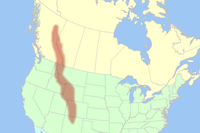
The Rocky Mountains are a major mountain range in western North America. The Rocky Mountains stretch more than from the northernmost part of British Columbia, in western Canada, to New Mexico, in the southwestern United States...
, a mountain system that stretches from Canada
Canada
Canada is a North American country consisting of ten provinces and three territories. Located in the northern part of the continent, it extends from the Atlantic Ocean in the east to the Pacific Ocean in the west, and northward into the Arctic Ocean...
through central New Mexico
New Mexico
New Mexico is a state located in the southwest and western regions of the United States. New Mexico is also usually considered one of the Mountain States. With a population density of 16 per square mile, New Mexico is the sixth-most sparsely inhabited U.S...
and which is part of the great mountain system known as the North American Cordillera
North American Cordillera
The North American Cordillera is the North American portion of the American Cordillera which is a cordillera extending up and down the western side of the Americas. The North American Cordillera covers an extensive area of mountain ranges, intermontane basins, and plateaus in western North...
.
The rocks making up the mountains were formed before the mountains were raised. In the north, the rocks were the original continental rocks formed more than one billion years ago. In the south, an older mountain range was formed 300 million years ago, then eroded away. The rocks of that older range were reformed into the Rocky Mountains
The Rocky Mountains took shape during an intense period of plate tectonic activity that resulted in much of the rugged landscape of the western North America
North America
North America is a continent wholly within the Northern Hemisphere and almost wholly within the Western Hemisphere. It is also considered a northern subcontinent of the Americas...
. The Laramide orogeny
Laramide orogeny
The Laramide orogeny was a period of mountain building in western North America, which started in the Late Cretaceous, 70 to 80 million years ago, and ended 35 to 55 million years ago. The exact duration and ages of beginning and end of the orogeny are in dispute, as is the cause. The Laramide...
, about 80–55 million years ago, was the last of the three episodes and was responsible for raising the Rocky Mountains. Subsequent erosion by glaciers has created the final form of the mountains.
Ancestral rock
The rocks in the Rocky Mountains were formed before the mountains were raised by tectonic forces. The oldest rock is PrecambrianPrecambrian
The Precambrian is the name which describes the large span of time in Earth's history before the current Phanerozoic Eon, and is a Supereon divided into several eons of the geologic time scale...
metamorphic rock
Metamorphic rock
Metamorphic rock is the transformation of an existing rock type, the protolith, in a process called metamorphism, which means "change in form". The protolith is subjected to heat and pressure causing profound physical and/or chemical change...
that forms the core of the North American continent. There is also Precambrian sedimentary argillite
Argillite
An argillite is a fine-grained sedimentary rock composed predominantly of indurated clay particles. Argillaceous rocks are basically lithified muds and oozes. They contain variable amounts of silt-sized particles. The argillites grade into shale when the fissile layering typical of shale is...
, dating back to 1.7 billion years ago. During the Paleozoic
Paleozoic
The Paleozoic era is the earliest of three geologic eras of the Phanerozoic eon, spanning from roughly...
, western North America lay underneath a shallow sea, which deposited many kilometers of limestone
Limestone
Limestone is a sedimentary rock composed largely of the minerals calcite and aragonite, which are different crystal forms of calcium carbonate . Many limestones are composed from skeletal fragments of marine organisms such as coral or foraminifera....
and dolomite
Dolomite
Dolomite is a carbonate mineral composed of calcium magnesium carbonate CaMg2. The term is also used to describe the sedimentary carbonate rock dolostone....
.
In the southern Rocky Mountains, near present-day Colorado
Colorado
Colorado is a U.S. state that encompasses much of the Rocky Mountains as well as the northeastern portion of the Colorado Plateau and the western edge of the Great Plains...
, these ancestral rocks were disturbed by mountain building approximately 300Ma, during the Pennsylvanian
Pennsylvanian
The Pennsylvanian is, in the ICS geologic timescale, the younger of two subperiods of the Carboniferous Period. It lasted from roughly . As with most other geochronologic units, the rock beds that define the Pennsylvanian are well identified, but the exact date of the start and end are uncertain...
. This mountain building produced the Ancestral Rocky Mountains. The uplift created two large mountainous islands, known to geologist
Geologist
A geologist is a scientist who studies the solid and liquid matter that constitutes the Earth as well as the processes and history that has shaped it. Geologists usually engage in studying geology. Geologists, studying more of an applied science than a theoretical one, must approach Geology using...
s as Frontrangia and Uncompahgria, located roughly in the current locations of the Front Range
Front Range
The Front Range is a mountain range of the Southern Rocky Mountains of North America located in the north-central portion of the U.S. State of Colorado and southeastern portion of the U.S. State of Wyoming. It is the first mountain range encountered moving west along the 40th parallel north across...
and the San Juan Mountains
San Juan Mountains
The San Juan Mountains are a high and rugged mountain range in the Rocky Mountains in southwestern Colorado. The area is highly mineralized and figured in the gold and silver mining industry of early Colorado. Major towns, all old mining camps, include Creede, Lake City, Silverton, Ouray, and...
. They consisted largely of Precambrian
Precambrian
The Precambrian is the name which describes the large span of time in Earth's history before the current Phanerozoic Eon, and is a Supereon divided into several eons of the geologic time scale...
metamorphic rock
Metamorphic rock
Metamorphic rock is the transformation of an existing rock type, the protolith, in a process called metamorphism, which means "change in form". The protolith is subjected to heat and pressure causing profound physical and/or chemical change...
forced upward through layers of the limestone
Limestone
Limestone is a sedimentary rock composed largely of the minerals calcite and aragonite, which are different crystal forms of calcium carbonate . Many limestones are composed from skeletal fragments of marine organisms such as coral or foraminifera....
laid down in the shallow sea. The mountains eroded throughout the late Paleozoic and early Mesozoic, leaving extensive deposits of sedimentary rock
Sedimentary rock
Sedimentary rock are types of rock that are formed by the deposition of material at the Earth's surface and within bodies of water. Sedimentation is the collective name for processes that cause mineral and/or organic particles to settle and accumulate or minerals to precipitate from a solution....
.
Continent
A continent is one of several very large landmasses on Earth. They are generally identified by convention rather than any strict criteria, with seven regions commonly regarded as continents—they are : Asia, Africa, North America, South America, Antarctica, Europe, and Australia.Plate tectonics is...
al environments
Sedimentary depositional environment
In geology, sedimentary depositional environment describes the combination of physical, chemical and biological processes associated with the deposition of a particular type of sediment and, therefore, the rock types that will be formed after lithification, if the sediment is preserved in the rock...
as local relative sea levels changed. By the close of the Mesozoic
Mesozoic
The Mesozoic era is an interval of geological time from about 250 million years ago to about 65 million years ago. It is often referred to as the age of reptiles because reptiles, namely dinosaurs, were the dominant terrestrial and marine vertebrates of the time...
, 10,000 to 15,000 feet (3000 to 4500 m) of sediment accumulated in 15 recognized formations. The most extensive non-marine formations were deposited in the Cretaceous
Cretaceous
The Cretaceous , derived from the Latin "creta" , usually abbreviated K for its German translation Kreide , is a geologic period and system from circa to million years ago. In the geologic timescale, the Cretaceous follows the Jurassic period and is followed by the Paleogene period of the...
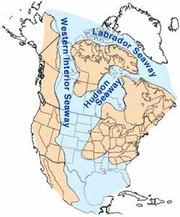
period when the western part of the Western Interior Seaway
Western Interior Seaway
The Western Interior Seaway, also called the Cretaceous Seaway, the Niobraran Sea, and the North American Inland Sea, was a huge inland sea that split the continent of North America into two halves, Laramidia and Appalachia, during most of the mid- and late-Cretaceous Period...
covered the region.
Terranes and subduction
Terranes started to collide with the western edge of North America in the Mississippian (approximately 350 million years ago), causing the Antler orogenyAntler orogeny
The Antler orogeny is a mountain-building episode that is named for Antler Peak, at Battle Mountain, Nevada. The orogeny extensively deformed Paleozoic rocks of the Great Basin in Nevada and western Utah during Late Devonian and Early Mississippian time...
. During the last half of the Mesozoic Era, much of today's California
California
California is a state located on the West Coast of the United States. It is by far the most populous U.S. state, and the third-largest by land area...
, British Columbia
British Columbia
British Columbia is the westernmost of Canada's provinces and is known for its natural beauty, as reflected in its Latin motto, Splendor sine occasu . Its name was chosen by Queen Victoria in 1858...
, Oregon
Oregon
Oregon is a state in the Pacific Northwest region of the United States. It is located on the Pacific coast, with Washington to the north, California to the south, Nevada on the southeast and Idaho to the east. The Columbia and Snake rivers delineate much of Oregon's northern and eastern...
, and Washington were added to North America
North America
North America is a continent wholly within the Northern Hemisphere and almost wholly within the Western Hemisphere. It is also considered a northern subcontinent of the Americas...
. Western North America suffered the effects of repeated collision as the Kula
Kula Plate
The Kula Plate is an oceanic tectonic plate under the northern Pacific Ocean south of the Near Islands segment of the Aleutian Islands. It is subducting under the North American Plate at the Aleutian Trench and is surrounded by the Pacific Plate...
and Farallon plate
Farallon Plate
The Farallon Plate was an ancient oceanic plate, which began subducting under the west coast of the North American Plate— then located in modern Utah— as Pangaea broke apart during the Jurassic Period...
s sank beneath the continental edge. Slivers of continental crust, carried along by subducting ocean plates, were swept into the subduction zone and scraped onto North America's western edge.
These terranes represent a variety of tectonic environments. Some are ancient island arcs, similar to Japan, Indonesia and the Aleutians; others are fragments of oceanic crust obducted onto the continental margin
Continental margin
The continental margin is the zone of the ocean floor that separates the thin oceanic crust from thick continental crust. Continental margins constitute about 28% of the oceanic area....
while others represent small isolated mid-oceanic islands.

Magma
Magma is a mixture of molten rock, volatiles and solids that is found beneath the surface of the Earth, and is expected to exist on other terrestrial planets. Besides molten rock, magma may also contain suspended crystals and dissolved gas and sometimes also gas bubbles. Magma often collects in...
generated above the subducting slab rose into the North American continental crust about 200 to 300 mi (321.9 to 482.8 km) inland. Great arc-shaped volcanic mountain ranges, known as the Sierran Arc
Sierran Arc
In early Triassic time, an extensive volcanic arc system, called the Sierran Arc began to develop along the western margin of the North American continent...
, grew as lava
Lava
Lava refers both to molten rock expelled by a volcano during an eruption and the resulting rock after solidification and cooling. This molten rock is formed in the interior of some planets, including Earth, and some of their satellites. When first erupted from a volcanic vent, lava is a liquid at...
and ash
Volcanic ash
Volcanic ash consists of small tephra, which are bits of pulverized rock and glass created by volcanic eruptions, less than in diameter. There are three mechanisms of volcanic ash formation: gas release under decompression causing magmatic eruptions; thermal contraction from chilling on contact...
spewed out of dozens of individual volcano
Volcano
2. Bedrock3. Conduit 4. Base5. Sill6. Dike7. Layers of ash emitted by the volcano8. Flank| 9. Layers of lava emitted by the volcano10. Throat11. Parasitic cone12. Lava flow13. Vent14. Crater15...
es. Beneath the surface, great masses of molten rock were injected and hardened in place.
For 270 million years, the effects of plate collisions were focused very near the edge of the North American plate boundary, far to the west of the Rocky Mountain region. It was not until 80 Ma that these effects began to reach the Rockies.
Raising the Rockies
The current Rocky Mountains were raised in the Laramide orogenyLaramide orogeny
The Laramide orogeny was a period of mountain building in western North America, which started in the Late Cretaceous, 70 to 80 million years ago, and ended 35 to 55 million years ago. The exact duration and ages of beginning and end of the orogeny are in dispute, as is the cause. The Laramide...
from between 80 to 55 Ma. For the Canadian Rockies, the mountain building is analogous to a rug being pushed on a hardwood floor: the rug bunches up and forms wrinkles (mountains). In Canada, the subduction of the Kula plate
Kula Plate
The Kula Plate is an oceanic tectonic plate under the northern Pacific Ocean south of the Near Islands segment of the Aleutian Islands. It is subducting under the North American Plate at the Aleutian Trench and is surrounded by the Pacific Plate...
and the terranes smashing into the continent are the feet pushing the rug, the ancestral rocks are the rug, and the Canadian Shield
Canadian Shield
The Canadian Shield, also called the Laurentian Plateau, or Bouclier Canadien , is a vast geological shield covered by a thin layer of soil that forms the nucleus of the North American or Laurentia craton. It is an area mostly composed of igneous rock which relates to its long volcanic history...
in the middle of the continent is the hardwood floor.
Further south, the growth of the Rocky Mountains in the United States is a geological puzzle. Mountain building is normally focused between 200 to 400 mi (321.9 to 643.7 km) inland from a subduction zone boundary. Geologists continue to gather evidence to explain the rise of the Rockies so much farther inland; the answer most likely lies with the unusual subduction of the Farallon plate
Farallon Plate
The Farallon Plate was an ancient oceanic plate, which began subducting under the west coast of the North American Plate— then located in modern Utah— as Pangaea broke apart during the Jurassic Period...
.
At a typical subduction zone, an oceanic plate typically sinks at a fairly steep angle, and a volcanic arc
Volcanic arc
A volcanic arc is a chain of volcanoes positioned in an arc shape as seen from above. Offshore volcanoes form islands, resulting in a volcanic island arc. Generally they result from the subduction of an oceanic tectonic plate under another tectonic plate, and often parallel an oceanic trench...
grows above the subducting plate. During the growth of the Rocky Mountains, the angle of the subducting plate may have been significantly flattened, moving the focus of melting and mountain building much farther inland than is normally expected. It is postulated that the shallow angle of the subducting plate greatly increased the friction and other interactions with the thick continental mass above it. Tremendous thrusts
Thrust fault
A thrust fault is a type of fault, or break in the Earth's crust across which there has been relative movement, in which rocks of lower stratigraphic position are pushed up and over higher strata. They are often recognized because they place older rocks above younger...
piled sheets of crust on top of each other, building the extraordinarily broad, high Rocky Mountain range.
Pennsylvanian
The Pennsylvanian is, in the ICS geologic timescale, the younger of two subperiods of the Carboniferous Period. It lasted from roughly . As with most other geochronologic units, the rock beds that define the Pennsylvanian are well identified, but the exact date of the start and end are uncertain...
and Permian
Permian
The PermianThe term "Permian" was introduced into geology in 1841 by Sir Sir R. I. Murchison, president of the Geological Society of London, who identified typical strata in extensive Russian explorations undertaken with Edouard de Verneuil; Murchison asserted in 1841 that he named his "Permian...
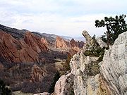
sedimentary remnants of the Ancestral Rocky Mountains. Such sedimentary remnants were often tilted at steep angles along the flanks of the modern range; they are now visible in many places throughout the Rockies, and are prominently shown along the Dakota Hogback
Dakota Hogback
The Dakota Hogback is a long hogback ridge at the eastern fringe of the Rocky Mountains that extends north-south from southern Wyoming through Colorado and into northern New Mexico in the United States. The ridge is prominently visible as the first line of foothills along the edge of the Great Plains...
, an early Cretaceous sandstone formation that runs along the eastern flank of the modern Rockies.
Current landscape
Immediately after the Laramide orogeny, the Rockies were like TibetTibet
Tibet is a plateau region in Asia, north-east of the Himalayas. It is the traditional homeland of the Tibetan people as well as some other ethnic groups such as Monpas, Qiang, and Lhobas, and is now also inhabited by considerable numbers of Han and Hui people...
: a high plateau, probably 6000 metres (19,685 ft) above sea level. In the last 60 million years, erosion
Erosion
Erosion is when materials are removed from the surface and changed into something else. It only works by hydraulic actions and transport of solids in the natural environment, and leads to the deposition of these materials elsewhere...
stripped away the high rocks, revealing the ancestral rocks beneath, and forming the current landscape of the Rockies.
Pleistocene
The Pleistocene is the epoch from 2,588,000 to 11,700 years BP that spans the world's recent period of repeated glaciations. The name pleistocene is derived from the Greek and ....
Epoch (1.8 million–70,000 years ago) to the Holocene
Holocene
The Holocene is a geological epoch which began at the end of the Pleistocene and continues to the present. The Holocene is part of the Quaternary period. Its name comes from the Greek words and , meaning "entirely recent"...
Epoch (fewer than 11,000 years ago). The ice age
Ice age
An ice age or, more precisely, glacial age, is a generic geological period of long-term reduction in the temperature of the Earth's surface and atmosphere, resulting in the presence or expansion of continental ice sheets, polar ice sheets and alpine glaciers...
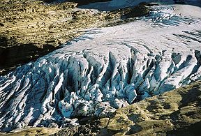
s left their mark on the Rockies, forming extensive glacial
Glacier
A glacier is a large persistent body of ice that forms where the accumulation of snow exceeds its ablation over many years, often centuries. At least 0.1 km² in area and 50 m thick, but often much larger, a glacier slowly deforms and flows due to stresses induced by its weight...
landforms, such as U-shaped valleys and cirque
Cirque
Cirque may refer to:* Cirque, a geological formation* Makhtesh, an erosional landform found in the Negev desert of Israel and Sinai of Egypt*Cirque , an album by Biosphere* Cirque Corporation, a company that makes touchpads...
s. Recent glacial episodes included the Bull Lake Glaciation
Bull Lake glaciation
The Bull Lake glaciation is the name of a glacial period in North America that is part of the Quaternary Ice Age. The Bull Lake glaciation began about 200,000 years ago and ended about 130,000 years ago, and was concurrent with the Illinoian Stage of the Quaternary Ice Age...
that began about 150,000 years ago and the Pinedale Glaciation that probably remained at full glaciation until 15,000–20,000 years ago. Ninety percent of Yellowstone National Park was covered by ice during the Pinedale Glaciation. The little ice age
Little Ice Age
The Little Ice Age was a period of cooling that occurred after the Medieval Warm Period . While not a true ice age, the term was introduced into the scientific literature by François E. Matthes in 1939...
was a period of glacial advance that lasted a few centuries from about 1550 to 1860. For example, the Agassiz
Agassiz Glacier
Agassiz Glacier is located in the U.S. state of Montana in Glacier National Park . It is named after Louis Agassiz, a Swiss-American glaciologist. The glacier is situated in a cirque to the southeast of Kintla Peak west of the Continental Divide. Agassiz Glacier is one of several glaciers that have...
and Jackson Glacier
Jackson Glacier
Jackson Glacier is approximately the seventh largest of the remaining 25 glaciers in Glacier National Park located in the U.S. state of Montana. A part of the largest grouping of glaciers in the park, Jackson Glacier rests on the north side of Mount Jackson...
s in Glacier National Park reached their most forward positions about 1860 during the Little Ice Age
Little Ice Age
The Little Ice Age was a period of cooling that occurred after the Medieval Warm Period . While not a true ice age, the term was introduced into the scientific literature by François E. Matthes in 1939...
.
All of the geological processes, above, have left a complex set of rocks exposed at the surface. For example, in the Rockies of Colorado, there is extensive granite
Granite
Granite is a common and widely occurring type of intrusive, felsic, igneous rock. Granite usually has a medium- to coarse-grained texture. Occasionally some individual crystals are larger than the groundmass, in which case the texture is known as porphyritic. A granitic rock with a porphyritic...
and gneiss
Gneiss
Gneiss is a common and widely distributed type of rock formed by high-grade regional metamorphic processes from pre-existing formations that were originally either igneous or sedimentary rocks.-Etymology:...
dating back to the Ancestral Rockies. In the central Canadian Rockies, the main ranges are composed of the Precambrian mudstone
Mudstone
Mudstone is a fine grained sedimentary rock whose original constituents were clays or muds. Grain size is up to 0.0625 mm with individual grains too small to be distinguished without a microscope. With increased pressure over time the platey clay minerals may become aligned, with the...
s, while the front ranges are composed of the Paleozoic
Paleozoic
The Paleozoic era is the earliest of three geologic eras of the Phanerozoic eon, spanning from roughly...
limestones and dolomites.Volcanic rock from the Tertiary
Tertiary
The Tertiary is a deprecated term for a geologic period 65 million to 2.6 million years ago. The Tertiary covered the time span between the superseded Secondary period and the Quaternary...
(65 million–1.8 million years ago) occurs in the San Juan Mountains
San Juan Mountains
The San Juan Mountains are a high and rugged mountain range in the Rocky Mountains in southwestern Colorado. The area is highly mineralized and figured in the gold and silver mining industry of early Colorado. Major towns, all old mining camps, include Creede, Lake City, Silverton, Ouray, and...
and in other areas. Millennia of severe erosion in the Wyoming Basin
Wyoming Basin
The Wyoming Basin physiographic province is a geographic area through which the Continental Divide of the Americas traverses. The province includes the Washakie and Great Divide Basins, and is demarcated by the following:*southwest: Uinta Mountains...
transformed intermountain basins into a relatively flat terrain. The Tetons and other north-central ranges contain folded and faulted rocks of Paleozoic
Paleozoic
The Paleozoic era is the earliest of three geologic eras of the Phanerozoic eon, spanning from roughly...
and Mesozoic
Mesozoic
The Mesozoic era is an interval of geological time from about 250 million years ago to about 65 million years ago. It is often referred to as the age of reptiles because reptiles, namely dinosaurs, were the dominant terrestrial and marine vertebrates of the time...
age draped above cores of Proterozoic
Proterozoic
The Proterozoic is a geological eon representing a period before the first abundant complex life on Earth. The name Proterozoic comes from the Greek "earlier life"...
and Archean
Archean
The Archean , also spelled Archeozoic or Archæozoic) is a geologic eon before the Paleoproterozoic Era of the Proterozoic Eon, before 2.5 Ga ago. Instead of being based on stratigraphy, this date is defined chronometrically...
igneous and metamorphic rocks ranging in age from 1.2 billion (e.g., Tetons) to more than 3.3 billion years (Beartooth Mountains
Beartooth Mountains
The Beartooth Mountains are located in south central Montana and northwest Wyoming, U.S. and are part of the 900,000 acre Absaroka-Beartooth Wilderness, within Custer, Gallatin and Shoshone National Forests. The Beartooths are the location of Granite Peak, which at 12,807 feet is the highest...
).