

List of islands of Scotland
Encyclopedia

Island
An island or isle is any piece of sub-continental land that is surrounded by water. Very small islands such as emergent land features on atolls can be called islets, cays or keys. An island in a river or lake may be called an eyot , or holm...
s of Scotland
Scotland
Scotland is a country that is part of the United Kingdom. Occupying the northern third of the island of Great Britain, it shares a border with England to the south and is bounded by the North Sea to the east, the Atlantic Ocean to the north and west, and the North Channel and Irish Sea to the...
, the mainland of which is part of the island of Great Britain
Great Britain
Great Britain or Britain is an island situated to the northwest of Continental Europe. It is the ninth largest island in the world, and the largest European island, as well as the largest of the British Isles...
. Also included are various other related tables and lists. The definition of an offshore island used in this list is that of "land that is surrounded by seawater on a daily basis, but not necessarily at all stages of the tide, excluding human devices such as bridges and causeways".
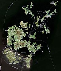
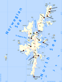
Scotland has over 790 offshore islands, most of which are to be found in four main groups: Shetland
Shetland Islands
Shetland is a subarctic archipelago of Scotland that lies north and east of mainland Great Britain. The islands lie some to the northeast of Orkney and southeast of the Faroe Islands and form part of the division between the Atlantic Ocean to the west and the North Sea to the east. The total...
, Orkney
Orkney Islands
Orkney also known as the Orkney Islands , is an archipelago in northern Scotland, situated north of the coast of Caithness...
, and the Hebrides
Hebrides
The Hebrides comprise a widespread and diverse archipelago off the west coast of Scotland. There are two main groups: the Inner and Outer Hebrides. These islands have a long history of occupation dating back to the Mesolithic and the culture of the residents has been affected by the successive...
, sub-divided into the Inner Hebrides
Inner Hebrides
The Inner Hebrides is an archipelago off the west coast of Scotland, to the south east of the Outer Hebrides. Together these two island chains form the Hebrides, which enjoy a mild oceanic climate. There are 36 inhabited islands and a further 43 uninhabited Inner Hebrides with an area greater than...
and Outer Hebrides
Outer Hebrides
The Outer Hebrides also known as the Western Isles and the Long Island, is an island chain off the west coast of Scotland. The islands are geographically contiguous with Comhairle nan Eilean Siar, one of the 32 unitary council areas of Scotland...
. There are also clusters of islands in the Firth of Clyde
Firth of Clyde
The Firth of Clyde forms a large area of coastal water, sheltered from the Atlantic Ocean by the Kintyre peninsula which encloses the outer firth in Argyll and Ayrshire, Scotland. The Kilbrannan Sound is a large arm of the Firth of Clyde, separating the Kintyre Peninsula from the Isle of Arran.At...
, Firth of Forth
Firth of Forth
The Firth of Forth is the estuary or firth of Scotland's River Forth, where it flows into the North Sea, between Fife to the north, and West Lothian, the City of Edinburgh and East Lothian to the south...
, and Solway Firth
Solway Firth
The Solway Firth is a firth that forms part of the border between England and Scotland, between Cumbria and Dumfries and Galloway. It stretches from St Bees Head, just south of Whitehaven in Cumbria, to the Mull of Galloway, on the western end of Dumfries and Galloway. The Isle of Man is also very...
, and numerous small islands within the many bodies of fresh water
Freshwater
Fresh water is naturally occurring water on the Earth's surface in ice sheets, ice caps, glaciers, bogs, ponds, lakes, rivers and streams, and underground as groundwater in aquifers and underground streams. Fresh water is generally characterized by having low concentrations of dissolved salts and...
in Scotland including Loch Lomond
Loch Lomond
Loch Lomond is a freshwater Scottish loch, lying on the Highland Boundary Fault. It is the largest lake in Great Britain by surface area. The lake contains many islands, including Inchmurrin, the largest fresh-water island in the British Isles, although the lake itself is smaller than many Irish...
and Loch Maree
Loch Maree
Loch Maree is a loch in Wester Ross in the Northwest Highlands of Scotland. At long and with a maximum width of , it is the fourth largest freshwater loch in Scotland; it is the largest north of Loch Ness. Its surface area is ....
.
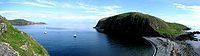
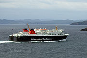
Many of these islands are swept by strong tides, and the Corryvreckan tide race
Gulf of Corryvreckan
The Gulf of Corryvreckan , also called the Strait of Corryvreckan, is a narrow strait between the islands of Jura and Scarba, in Argyll and Bute, off the west coast of Scotland.It is possible for tourists to visit the site by way of boats trips from local harbours.- Topography...
between Scarba
Scarba
Scarba is a small island, in Argyll and Bute, Scotland, just north of the much larger island of Jura. The island is owned by Richard Hill, 7th Baron Sandys and has not been permanently inhabited since the 1960s. It is now covered in heather and used for grazing animals...
and Jura
Jura, Scotland
Jura is an island in the Inner Hebrides of Scotland, situated adjacent and to the north-east of Islay. Part of the island is designated as a National Scenic Area. Until the twentieth century Jura was dominated - and most of it was eventually owned - by the Campbell clan of Inveraray Castle on Loch...
is one of the largest whirlpools in the world. Other strong tides are to be found in the Pentland Firth
Pentland Firth
The Pentland Firth , which is actually more of a strait than a firth, separates the Orkney Islands from Caithness in the north of Scotland.-Etymology:...
between mainland Scotland and Orkney, and another example is the "Grey Dog" between Scarba and Lunga
Lunga, Firth of Lorn
Lunga is one of the Slate Islands in the Firth of Lorn, Scotland. The "Grey Dog" tidal race, which runs in the sea channel to the south, reaches 8 knots in full flood. The name 'Lunga' is derived from the Old Norse for 'isle of the longships', but almost all other place names are Gaelic in origin...
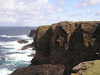
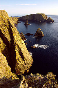
. The geology and geomorphology of the islands is varied. Some, such as Skye
Skye
Skye or the Isle of Skye is the largest and most northerly island in the Inner Hebrides of Scotland. The island's peninsulas radiate out from a mountainous centre dominated by the Cuillin hills...
and Mull
Isle of Mull
The Isle of Mull or simply Mull is the second largest island of the Inner Hebrides, off the west coast of Scotland in the council area of Argyll and Bute....
are mountainous, whilst others like Tiree
Tiree
-History:Tiree is known for the 1st century BC Dùn Mòr broch, for the prehistoric carved Ringing Stone and for the birds of the Ceann a' Mhara headland....
and Sanday
Sanday, Orkney
Sanday is one of the inhabited islands in the Orkney Islands, off the north coast of Scotland. With an area of , it is the third largest of the Orkney Islands. The main centres of population are Lady Village and Kettletoft. Sanday can be reached by Orkney Ferries or plane from Kirkwall on the...
are relatively low lying. Many have bedrock made from ancient Archaean Lewisian Gneiss
Lewisian complex
The Lewisian complex or Lewisian Gneiss is a suite of Precambrian metamorphic rocks that outcrop in the northwestern part of Scotland, forming part of the Hebridean Terrane. These rocks are of Archaean and Paleoproterozoic age, ranging from 3.0–1.7 Ga. They form the basement on which the...
which was formed 3 billion years ago; Shapinsay
Shapinsay
Shapinsay is one of the Orkney Islands off the north coast of mainland Scotland. There is one village on the island, Balfour, from which roll-on/roll-off car ferries sail to Kirkwall on the Orkney Mainland...
and other Orkney islands are formed from Old Red Sandstone
Old Red Sandstone
The Old Red Sandstone is a British rock formation of considerable importance to early paleontology. For convenience the short version of the term, 'ORS' is often used in literature on the subject.-Sedimentology:...
, which is 400 million years old; and others such as Rùm
Rùm
Rùm , a Scottish Gaelic name often anglicised to Rum) is one of the Small Isles of the Inner Hebrides, in the district of Lochaber, Scotland...
from more recent Tertiary
Tertiary
The Tertiary is a deprecated term for a geologic period 65 million to 2.6 million years ago. The Tertiary covered the time span between the superseded Secondary period and the Quaternary...
volcanoes.
The largest island is Lewis and Harris
Lewis and Harris
Lewis and Harris in the Outer Hebrides make up the largest island in Scotland. This is the largest single island of the British Isles after Great Britain and Ireland.-Geography:...
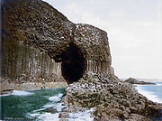
which extends to 2,179 square kilometres, and there are a further 200 islands which are greater than 40 hectares in area. Of the remainder, several such as Staffa
Staffa
Staffa from the Old Norse for stave or pillar island, is an island of the Inner Hebrides in Argyll and Bute, Scotland. The Vikings gave it this name as its columnar basalt reminded them of their houses, which were built from vertically placed tree-logs....
and the Flannan Isles
Flannan Isles
Designed by David Alan Stevenson, the tower was constructed for the Northern Lighthouse Board between 1895 and 1899 and is located near the highest point on Eilean Mòr. Construction was undertaken by George Lawson of Rutherglen at a cost of £6,914 inclusive of the building of the landing places,...
are well known despite their small size.
Some 99 Scottish islands are populated, of which 94 are offshore islands. The local government council areas with the most inhabited islands are Argyll and Bute
Argyll and Bute
Argyll and Bute is both one of 32 unitary council areas; and a Lieutenancy area in Scotland. The administrative centre for the council area is located in Lochgilphead.Argyll and Bute covers the second largest administrative area of any Scottish council...
with 26, Orkney with 20, Shetland with 16 and Highland
Highland (council area)
Highland is a council area in the Scottish Highlands and is the largest local government area in both Scotland and the United Kingdom as a whole. It shares borders with the council areas of Moray, Aberdeenshire, Perth and Kinross, and Argyll and Bute. Their councils, and those of Angus and...
and Comhairle nan Eilean Siar
Comhairle nan Eilean Siar
Comhairle nan Eilean Siar is the local government council for Na h-Eileanan Siar council area of Scotland.It is the only local council in Scotland to have a Gaelic-only name...
with 15 each. Many previously inhabited islands such as Mingulay
Mingulay
Mingulay is the second largest of the Bishop's Isles in the Outer Hebrides of Scotland. Located south of Barra, it is known for its important seabird populations, including puffins, Black-legged Kittiwakes, and razorbills, which nest in the sea-cliffs, amongst the highest in the British...
, Noss
Noss
Noss is a small, previously inhabited island in Shetland, Scotland. It is a sheep farm and has been a National Nature Reserve since 1955.-Geography:...
and the St Kilda
St Kilda, Scotland
St Kilda is an isolated archipelago west-northwest of North Uist in the North Atlantic Ocean. It contains the westernmost islands of the Outer Hebrides of Scotland. The largest island is Hirta, whose sea cliffs are the highest in the United Kingdom and three other islands , were also used for...
archipelago have been abandoned during the course of the past century and today only 14 islands are populated by over 1,000 people and 45 by over 100. Between 1991 and 2001, the population of the islands fell by 3% overall, although there were 35 islands whose population increased. The total population of all the islands in 2001 was 99,739.
The culture of the islands has been affected by the successive influences of Celtic, Norse and English
English language
English is a West Germanic language that arose in the Anglo-Saxon kingdoms of England and spread into what was to become south-east Scotland under the influence of the Anglian medieval kingdom of Northumbria...
speaking peoples and this is reflected in names given to the islands. Most of the Hebrides
Hebrides
The Hebrides comprise a widespread and diverse archipelago off the west coast of Scotland. There are two main groups: the Inner and Outer Hebrides. These islands have a long history of occupation dating back to the Mesolithic and the culture of the residents has been affected by the successive...
have names with Scots Gaelic
Scottish Gaelic language
Scottish Gaelic is a Celtic language native to Scotland. A member of the Goidelic branch of the Celtic languages, Scottish Gaelic, like Modern Irish and Manx, developed out of Middle Irish, and thus descends ultimately from Primitive Irish....
derivations, whilst those of the Northern Isles
Northern Isles
The Northern Isles is a chain of islands off the north coast of mainland Scotland. The climate is cool and temperate and much influenced by the surrounding seas. There are two main island groups: Shetland and Orkney...
tend to be derived from the Viking
Viking
The term Viking is customarily used to refer to the Norse explorers, warriors, merchants, and pirates who raided, traded, explored and settled in wide areas of Europe, Asia and the North Atlantic islands from the late 8th to the mid-11th century.These Norsemen used their famed longships to...
names. A few have Brythonic
Britons (historical)
The Britons were the Celtic people culturally dominating Great Britain from the Iron Age through the Early Middle Ages. They spoke the Insular Celtic language known as British or Brythonic...
, Scots
Scots language
Scots is the Germanic language variety spoken in Lowland Scotland and parts of Ulster . It is sometimes called Lowland Scots to distinguish it from Scottish Gaelic, the Celtic language variety spoken in most of the western Highlands and in the Hebrides.Since there are no universally accepted...
and even perhaps pre-Celtic roots.
A feature of modern island life is the low crime rate and they are considered to be amongst the safest places to live in Britain
United Kingdom
The United Kingdom of Great Britain and Northern IrelandIn the United Kingdom and Dependencies, other languages have been officially recognised as legitimate autochthonous languages under the European Charter for Regional or Minority Languages...
.
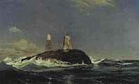
Rockall
Rockall
Rockall is an extremely small, uninhabited, remote rocky islet in the North Atlantic Ocean. It gives its name to one of the sea areas named in the shipping forecast provided by the British Meteorological Office....
is a small rocky islet in the North Atlantic which was declared part of Scotland by the Island of Rockall Act 1972
Island of Rockall Act 1972
The Island of Rockall Act 1972 is a British Act of Parliament formally incorporating the island Rockall into the United Kingdom to protect it from Irish and Icelandic claims...
. However, the legality of the claim is disputed by the Republic of Ireland
Republic of Ireland
Ireland , described as the Republic of Ireland , is a sovereign state in Europe occupying approximately five-sixths of the island of the same name. Its capital is Dublin. Ireland, which had a population of 4.58 million in 2011, is a constitutional republic governed as a parliamentary democracy,...
, Denmark
Denmark
Denmark is a Scandinavian country in Northern Europe. The countries of Denmark and Greenland, as well as the Faroe Islands, constitute the Kingdom of Denmark . It is the southernmost of the Nordic countries, southwest of Sweden and south of Norway, and bordered to the south by Germany. Denmark...
and Iceland
Iceland
Iceland , described as the Republic of Iceland, is a Nordic and European island country in the North Atlantic Ocean, on the Mid-Atlantic Ridge. Iceland also refers to the main island of the country, which contains almost all the population and almost all the land area. The country has a population...
and it is probably unenforceable in international law.
Larger islands
This is a list of Scottish islands that either have an area greater than 40 hectares (approximately 100 acres) and/or are inhabited. The main groups, from Haswell-Smith (2004), in many cases provide a more useful guide to location than local authority areas. These groups are: Firth of ClydeFirth of Clyde
The Firth of Clyde forms a large area of coastal water, sheltered from the Atlantic Ocean by the Kintyre peninsula which encloses the outer firth in Argyll and Ayrshire, Scotland. The Kilbrannan Sound is a large arm of the Firth of Clyde, separating the Kintyre Peninsula from the Isle of Arran.At...
, Islay
Islay
-Prehistory:The earliest settlers on Islay were nomadic hunter-gatherers who arrived during the Mesolithic period after the retreat of the Pleistocene ice caps. In 1993 a flint arrowhead was found in a field near Bridgend dating from 10,800 BC, the earliest evidence of a human presence found so far...
, Firth of Lorn, Mull
Isle of Mull
The Isle of Mull or simply Mull is the second largest island of the Inner Hebrides, off the west coast of Scotland in the council area of Argyll and Bute....
, Small Isles
Small Isles
The Small Isles are a small archipelago of islands in the Inner Hebrides, off the west coast of Scotland. They lie south of Skye and north of Mull and Ardnamurchan – the most westerly point of mainland Scotland.The four main islands are Canna, Rùm, Eigg and Muck...
, Skye
Skye
Skye or the Isle of Skye is the largest and most northerly island in the Inner Hebrides of Scotland. The island's peninsulas radiate out from a mountainous centre dominated by the Cuillin hills...
, Lewis and Harris
Lewis and Harris
Lewis and Harris in the Outer Hebrides make up the largest island in Scotland. This is the largest single island of the British Isles after Great Britain and Ireland.-Geography:...
, Uist
Uist
Uist or The Uists are the central group of islands in the Outer Hebrides of Scotland.North Uist and South Uist are linked by causeways running via Benbecula and Grimsay, and the entire group is sometimes known as the Uists....
s and Barra
Barra
The island of Barra is a predominantly Gaelic-speaking island, and apart from the adjacent island of Vatersay, to which it is connected by a causeway, is the southernmost inhabited island of the Outer Hebrides in Scotland.-Geography:The 2001 census showed that the resident population was 1,078...
, St Kilda
St Kilda, Scotland
St Kilda is an isolated archipelago west-northwest of North Uist in the North Atlantic Ocean. It contains the westernmost islands of the Outer Hebrides of Scotland. The largest island is Hirta, whose sea cliffs are the highest in the United Kingdom and three other islands , were also used for...
, Orkney, Shetland and Firth of Forth
Firth of Forth
The Firth of Forth is the estuary or firth of Scotland's River Forth, where it flows into the North Sea, between Fife to the north, and West Lothian, the City of Edinburgh and East Lothian to the south...
. In a few cases where the island is part of either a recognisable smaller group or an archipelago, or is located away from the main groups, an archipelago, local authority or other descriptive name is used instead. "F" designates a freshwater island.


| Island | Group | Area (ha Hectare The hectare is a metric unit of area defined as 10,000 square metres , and primarily used in the measurement of land. In 1795, when the metric system was introduced, the are was defined as being 100 square metres and the hectare was thus 100 ares or 1/100 km2... ) |
Population | Height (m) |
|---|---|---|---|---|
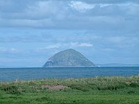
| Ailsa Craig Ailsa Craig Ailsa Craig is an island of 219.69 acres in the outer Firth of Clyde, Scotland where blue hone granite was quarried to make curling stones. "Ailsa" is pronounced "ale-sa", with the first syllable stressed... (Creag Ealasaid) |
Firth of Clyde Islands of the Clyde The Islands of the Firth of Clyde are the fifth largest of the major Scottish island groups after the Inner and Outer Hebrides, Orkney and Shetland. They are situated in the Firth of Clyde between Ayrshire and Argyll. There are about forty islands and skerries, of which only six are inhabited and... |
99 | 0 | 338 |
| Arran Isle of Arran Arran or the Isle of Arran is the largest island in the Firth of Clyde, Scotland, and with an area of is the seventh largest Scottish island. It is in the unitary council area of North Ayrshire and the 2001 census had a resident population of 5,058... (Eilean Arainn) |
Firth of Clyde Islands of the Clyde The Islands of the Firth of Clyde are the fifth largest of the major Scottish island groups after the Inner and Outer Hebrides, Orkney and Shetland. They are situated in the Firth of Clyde between Ayrshire and Argyll. There are about forty islands and skerries, of which only six are inhabited and... |
43,201 | 5045 | 874 |
| Auskerry Auskerry Auskerry is a small island in eastern Orkney, Scotland. It lies in the North Sea south of Stronsay and has a lighthouse, completed in 1866.-Description:... |
Orkney | 85 | 5 | 18 |
| Baleshare Baleshare Baleshare is a flat tidal island in the Outer Hebrides of Scotland.Baleshare lies to the south-west of North Uist. Its economics and community were boosted by the building of a causeway in 1962. The 350m causeway was built by William Tawse Ltd. The island is extremely flat by Hebridean standards,... (Baile Sear) |
Uist Uist Uist or The Uists are the central group of islands in the Outer Hebrides of Scotland.North Uist and South Uist are linked by causeways running via Benbecula and Grimsay, and the entire group is sometimes known as the Uists.... s and Barra Barra The island of Barra is a predominantly Gaelic-speaking island, and apart from the adjacent island of Vatersay, to which it is connected by a causeway, is the southernmost inhabited island of the Outer Hebrides in Scotland.-Geography:The 2001 census showed that the resident population was 1,078... |
910 | 49 | 12 |
| Balta | Shetland | 80 | 0 | 44 |
| Barra Barra The island of Barra is a predominantly Gaelic-speaking island, and apart from the adjacent island of Vatersay, to which it is connected by a causeway, is the southernmost inhabited island of the Outer Hebrides in Scotland.-Geography:The 2001 census showed that the resident population was 1,078... (Barraigh) |
Uist Uist Uist or The Uists are the central group of islands in the Outer Hebrides of Scotland.North Uist and South Uist are linked by causeways running via Benbecula and Grimsay, and the entire group is sometimes known as the Uists.... s and Barra Barra The island of Barra is a predominantly Gaelic-speaking island, and apart from the adjacent island of Vatersay, to which it is connected by a causeway, is the southernmost inhabited island of the Outer Hebrides in Scotland.-Geography:The 2001 census showed that the resident population was 1,078... |
5,875 | 1078 | 383 |
| Barra Head Barra Head Barra Head, also known as Berneray , is the southernmost of the Outer Hebrides in Scotland. Within the Outer Hebrides, it forms part of the Barra Isles archipelago. Originally, Barra Head only referred to the southernmost headland of Berneray but is now a common name for the entire island... (Beàrnaraigh) |
Uist Uist Uist or The Uists are the central group of islands in the Outer Hebrides of Scotland.North Uist and South Uist are linked by causeways running via Benbecula and Grimsay, and the entire group is sometimes known as the Uists.... s and Barra Barra The island of Barra is a predominantly Gaelic-speaking island, and apart from the adjacent island of Vatersay, to which it is connected by a causeway, is the southernmost inhabited island of the Outer Hebrides in Scotland.-Geography:The 2001 census showed that the resident population was 1,078... |
204 | 0 | 193 |
| Benbecula Benbecula Benbecula is an island of the Outer Hebrides in the Atlantic Ocean off the west coast of Scotland. In the 2001 census it had a usually resident population of 1,249, with a sizable percentage of Roman Catholics. It forms part of the area administered by Comhairle nan Eilean Siar or the Western... (Beinn nam Fadhla) |
Uist Uist Uist or The Uists are the central group of islands in the Outer Hebrides of Scotland.North Uist and South Uist are linked by causeways running via Benbecula and Grimsay, and the entire group is sometimes known as the Uists.... s and Barra Barra The island of Barra is a predominantly Gaelic-speaking island, and apart from the adjacent island of Vatersay, to which it is connected by a causeway, is the southernmost inhabited island of the Outer Hebrides in Scotland.-Geography:The 2001 census showed that the resident population was 1,078... |
8,203 | 1219 | 124 |
| Berneray, North Uist Berneray, North Uist Berneray is an island and community in the Sound of Harris, Scotland. It is one of fifteen inhabited islands in the Outer Hebrides. It is famed for its rich and colourful history which has attracted much tourism.... (Beàrnaraidh) |
Uist Uist Uist or The Uists are the central group of islands in the Outer Hebrides of Scotland.North Uist and South Uist are linked by causeways running via Benbecula and Grimsay, and the entire group is sometimes known as the Uists.... s and Barra Barra The island of Barra is a predominantly Gaelic-speaking island, and apart from the adjacent island of Vatersay, to which it is connected by a causeway, is the southernmost inhabited island of the Outer Hebrides in Scotland.-Geography:The 2001 census showed that the resident population was 1,078... |
1,010 | 136 | 93 |
|-
| Bigga
Bigga, Shetland
Bigga is an uninhabited island in the Sound of Yell between the Mainland and Yell in Shetland, Scotland.-Geography and geology:Just over long, Bigga is in size, and is tall at its highest point. Bigga is a long thin island with a "head" and a "torso"...
| Shetland
| 78
| 0
| 34
|-
| Boreray
Boreray, St Kilda
Boreray is an uninhabited island in the St Kilda archipelago in the North Atlantic.-Geography:Boreray lies about 66 km west-north-west of North Uist. It covers about , and reaches a height of at Mullach an Eilein....
(Boraraigh)
| St Kilda
St Kilda, Scotland
St Kilda is an isolated archipelago west-northwest of North Uist in the North Atlantic Ocean. It contains the westernmost islands of the Outer Hebrides of Scotland. The largest island is Hirta, whose sea cliffs are the highest in the United Kingdom and three other islands , were also used for...
| 77
| 0
| 384
|-
| Boreray
Boreray, North Uist
Boreray is an island, with a single crofter, lying north of North Uist in the Outer Hebrides of Scotland.The island is dominated by Loch Mòr .-History:...
(Boraraigh)
| Uist
Uist
Uist or The Uists are the central group of islands in the Outer Hebrides of Scotland.North Uist and South Uist are linked by causeways running via Benbecula and Grimsay, and the entire group is sometimes known as the Uists....
s and Barra
Barra
The island of Barra is a predominantly Gaelic-speaking island, and apart from the adjacent island of Vatersay, to which it is connected by a causeway, is the southernmost inhabited island of the Outer Hebrides in Scotland.-Geography:The 2001 census showed that the resident population was 1,078...
| 204
| 0
| 56
|-
| Bressay
Bressay
-Geography and geology:Bressay lies due south of Whalsay, west of Noss, and north of Mousa. At , it is the fifth largest island in Shetland. The population is around 400 people, concentrated in the middle of the west coast, around Glebe, Fullaburn and Maryfield....
| Shetland
| 2,805
| 384
| 226
|-
| Brother Isle
Brother Isle
Brother Isle is a small, uninhabited island in Shetland, Scotland. It lies between the islands of Yell and Shetland Mainland. It is in size.- Geography and geology :The island's rock is "undifferentiated moine gneiss and quartzite."- History :...
| Shetland
| 40
| 0
| 25
|-
| Bruray
Bruray
Bruray is one of the three Out Skerries islands of Shetland, and contains Scotland's most easterly settlement.It is separated from Housay by North Mouth and South Mouth.-Infrastructure:...
| Out Skerries
| 55
| 26
| 53
|-
| Burray
Burray
Burray is one of the Orkney Islands in Scotland. It lies to the east of Scapa Flow and is one of a chain of islands linked by the Churchill Barriers.-Geography and geology:...
| Orkney
| 903
| 357
| 80
|-
| Bute
Isle of Bute
Bute is an island in the Firth of Clyde in Scotland. Formerly part of the county of Buteshire, it now constitutes part of the council area of Argyll and Bute. Its resident population was 7,228 in April 2001.-Geography:...
(Eilean Bhòid)
| Firth of Clyde
Islands of the Clyde
The Islands of the Firth of Clyde are the fifth largest of the major Scottish island groups after the Inner and Outer Hebrides, Orkney and Shetland. They are situated in the Firth of Clyde between Ayrshire and Argyll. There are about forty islands and skerries, of which only six are inhabited and...
| 12,217
| 7149
| 278
|-
| Calf of Eday
Calf of Eday
The Calf of Eday is an island in Orkney, Scotland, lying north east of Eday."Calf" is a name usually given to a small island alongside a larger one, e.g...
| Orkney
| 243
| 0
| 54
|-
| Calve Island
Calve Island
Calve Island is an uninhabited island on the east coast of the Isle of Mull in Argyll and Bute on the west coast of Scotland. It provides some shelter for Tobermory Bay and is separated from Mull by a tidal channel. The island is a mile in length...
| Mull
Isle of Mull
The Isle of Mull or simply Mull is the second largest island of the Inner Hebrides, off the west coast of Scotland in the council area of Argyll and Bute....
| 72
| 0
| 20
|-
| Canna
Canna, Scotland
Canna is the westernmost of the Small Isles archipelago, in the Scottish Inner Hebrides. It is linked to the neighbouring island of Sanday by a road and sandbanks at low tide. The island is long and wide...
(Eilean Chanaigh)
| Small Isles
Small Isles
The Small Isles are a small archipelago of islands in the Inner Hebrides, off the west coast of Scotland. They lie south of Skye and north of Mull and Ardnamurchan – the most westerly point of mainland Scotland.The four main islands are Canna, Rùm, Eigg and Muck...
| 1,130
| 6
| 210
|-
| Cara
Cara Island
Cara Island is a small island which is located off the west coast of Kintyre in Scotland.-Geography and etymology:Cara is south of Gigha. It is accessible from Gigha, if you can find a local boatman who will take you over...
| Islay
Islay
-Prehistory:The earliest settlers on Islay were nomadic hunter-gatherers who arrived during the Mesolithic period after the retreat of the Pleistocene ice caps. In 1993 a flint arrowhead was found in a field near Bridgend dating from 10,800 BC, the earliest evidence of a human presence found so far...
| 66
| 0
| 56
|-
| Càrna
Càrna
Càrna is an island in Loch Sunart, an arm of the sea, close to the Ardnamurchan peninsula, on the west coast of Scotland.-Geography:Càrna lies across the mouth of Loch Teacuis, forming two narrow kyles which provide some of the trickiest rock-dodging for yachtsmen anywhere on the west coast...
| Mull
Isle of Mull
The Isle of Mull or simply Mull is the second largest island of the Inner Hebrides, off the west coast of Scotland in the council area of Argyll and Bute....
| 213
| 0
| 169
|-
| Cava
Cava, Orkney
Cava is an uninhabited island in the Orkney archipelago in Scotland. It is in extent and rises to above sea level. The literal meaning of the name is 'calf island', a terminology often used to designate a small island near to a larger one...
| Orkney
| 107
| 0
| 38
|-
| Ceallasaigh Mòr
Ceallasaigh Mòr
Ceallasaigh Mòr is a low-lying island in Loch Maddy off North Uist in the Outer Hebrides of Scotland.-Footnotes:...
| Uist
Uist
Uist or The Uists are the central group of islands in the Outer Hebrides of Scotland.North Uist and South Uist are linked by causeways running via Benbecula and Grimsay, and the entire group is sometimes known as the Uists....
s and Barra
Barra
The island of Barra is a predominantly Gaelic-speaking island, and apart from the adjacent island of Vatersay, to which it is connected by a causeway, is the southernmost inhabited island of the Outer Hebrides in Scotland.-Geography:The 2001 census showed that the resident population was 1,078...
| 44 *
| 0
| 10
|-
| Ceann Ear
Ceann Ear
Disambiguation: "Ceann Ear" is a common Scottish placename meaning Eastern HeadlandCeann Ear is the largest island in the Monach or Heisgeir group off North Uist in north west Scotland. It is in size and connected by sandbanks to Ceann Iar via Sibhinis at low tide. It is said that it was at one...
| Monach Islands
Monach Islands
Not to be confused with Heysker/Hyskeir or HaskeirThe Monach Islands, also known as Heisker , are an island group west of North Uist in the Outer Hebrides of Scotland...
| 203
| 0
| 17
|-
| Ceann Iar
Ceann Iar
Disambiguation: "Ceann Iar" is a common Scottish placename meaning Western HeadlandCeann Iar is one of the Monach Isles/Heisgeir, to the west of North Uist in the Outer Hebrides. It is a slender island, approximately a mile, or two kilometres long.-Geography:Ceann Iar is the second largest of the...
| Monach Islands
Monach Islands
Not to be confused with Heysker/Hyskeir or HaskeirThe Monach Islands, also known as Heisker , are an island group west of North Uist in the Outer Hebrides of Scotland...
| 154
| 0
| 19
|-
| Coll
Coll
Coll is a small island, west of Mull in the Inner Hebrides of Scotland. Coll is known for its sandy beaches, which rise to form large sand dunes, for its corncrakes, and for Breachacha Castle.-Geography and geology:...
(Colla)
| Mull
Isle of Mull
The Isle of Mull or simply Mull is the second largest island of the Inner Hebrides, off the west coast of Scotland in the council area of Argyll and Bute....
| 7,685
| 164
| 104
|-
| Colonsay
Colonsay
Colonsay is an island in the Scottish Inner Hebrides, located north of Islay and south of Mull and has an area of . It is the ancestral home of Clan Macfie and the Colonsay branch of Clan MacNeill. Aligned on a south-west to north-east axis, it measures in length and reaches at its widest...
(Colbhasa)
| Islay
Islay
-Prehistory:The earliest settlers on Islay were nomadic hunter-gatherers who arrived during the Mesolithic period after the retreat of the Pleistocene ice caps. In 1993 a flint arrowhead was found in a field near Bridgend dating from 10,800 BC, the earliest evidence of a human presence found so far...
| 4,074
| 108
| 143
|-
| Copinsay
Copinsay
'Copinsay is one of the Orkney Islands in Scotland, lying off the east coast of the Orkney Mainland. The smaller companion island to Copinsay is called the Horse of Copinsay and lies to the north east to the main island. The island is now uninhabited and managed as a bird reserve...
| Orkney
| 73
| 0
| 64
|-
| Danna
Danna, Scotland
Danna Island is a tidal island in Argyll and Bute. It is connected to the mainland by a stone causeway and is at the southern end of the narrow Tayvallich peninsula, which separates Loch Sween from the Sound of Jura. It is part of the Ulva, Danna and the MacCormaig Isles SSSI. Danna is part of the...
| Islay
Islay
-Prehistory:The earliest settlers on Islay were nomadic hunter-gatherers who arrived during the Mesolithic period after the retreat of the Pleistocene ice caps. In 1993 a flint arrowhead was found in a field near Bridgend dating from 10,800 BC, the earliest evidence of a human presence found so far...
| 315 *
| 5
| 54
|-
| Davaar (Eilean Dà Bhàrr)
| Firth of Clyde
Islands of the Clyde
The Islands of the Firth of Clyde are the fifth largest of the major Scottish island groups after the Inner and Outer Hebrides, Orkney and Shetland. They are situated in the Firth of Clyde between Ayrshire and Argyll. There are about forty islands and skerries, of which only six are inhabited and...
| 52 *
| 2
| 115
|-
| Easdale
Easdale
Easdale is one of the Slate Islands, in the Firth of Lorn, Scotland. Once the centre of the British slate industry, there has been some recent island regeneration....
(Eilean Eisdeal)
| Slate Islands
Slate Islands
The Slate Islands are an island group in the Inner Hebrides, lying immediately off the west coast of Scotland, north of Jura and southwest of Oban. The main islands are Seil, Easdale, Luing, Lunga, Shuna, Torsa and Belnahua...
| <20 *
| 58
| 38
|-
| East Burra
East Burra
East Burra is one of the Scalloway Islands, a subgroup of the Shetland Islands in Scotland. It is connected by a bridge to West Burra.With an area of two square miles, it is the eleventh largest of the Shetland Islands....
| Shetland
| 515
| 66
| 81
|-
| Eday
Eday
Eday is one of the Orkney Islands, which are located to the north of the Scottish mainland in the United Kingdom. Eday is located in the North Isles of Orkney, and is about north of the main island of Orkney Mainland...
| Orkney
| 2,745
| 121
| 101
|-
| Egilsay
Egilsay
Egilsay is one of the Orkney Islands in Scotland, lying east of Rousay. The island is largely farmland and is known for its corncrakes.-St. Magnus Church:...
| Orkney
| 650
| 37
| 35
|-
| Eigg
Eigg
Eigg is one of the Small Isles, in the Scottish Inner Hebrides. It lies to the south of the Skye and to the north of the Ardnamurchan peninsula. Eigg is long from north to south, and east to west. With an area of , it is the second largest of the Small Isles after Rùm.-Geography:The main...
(Eige)
| Small Isles
Small Isles
The Small Isles are a small archipelago of islands in the Inner Hebrides, off the west coast of Scotland. They lie south of Skye and north of Mull and Ardnamurchan – the most westerly point of mainland Scotland.The four main islands are Canna, Rùm, Eigg and Muck...
| 3,049
| 67
| 393
|-
| Eileach an Naoimh
Eileach an Naoimh
Eileach an Naoimh, also known as Holy Isle, is an uninhabited island in the Inner Hebrides of the west coast of Scotland. It is the southernmost of the Garvellachs archipelago and lies in Firth of Lorne between Mull and Argyll. The name is Gaelic for "rocky place of the saint".About 542, St...
| Garvellachs
Garvellachs
The Garvellachs or Isles of the Sea form a small archipelago in the Inner Hebrides of Scotland. Part of the Argyll and Bute council area, they lie west of Lunga and northwest of Scarba and have been uninhabited since World War II.The islands include Garbh Eileach, Dùn Channuill and Eileach an...
| 56
| 0
| 80
|-
| Eilean Bàn, Lochalsh
| Highland
Highland (council area)
Highland is a council area in the Scottish Highlands and is the largest local government area in both Scotland and the United Kingdom as a whole. It shares borders with the council areas of Moray, Aberdeenshire, Perth and Kinross, and Argyll and Bute. Their councils, and those of Angus and...
| <10 *
| 2
| 5
|-
| Eilean Chaluim Chille
Eilean Chaluim Chille
Eilean Chaluim Chille is an unpopulated island in the Outer Hebrides.It lies off the east coast of Lewis at the mouth of Loch Erisort. At low tide Eilean Chaluim Chille is connected by a causeway to the mainland of Lewis at Crobeag.-History:At the southern end of the island lie the ruins of St...
| Lewis and Harris
Lewis and Harris
Lewis and Harris in the Outer Hebrides make up the largest island in Scotland. This is the largest single island of the British Isles after Great Britain and Ireland.-Geography:...
| 85
| 0
| 43
|-
| Eilean Chearstaidh
Eilean Chearstaidh
Eilean Kearstay is an uninhabited island in Loch Roag in the Outer Hebrides of Scotland.It lies south east of Great Bernera, just across the water from the headland of Callanish....
| Lewis and Harris
Lewis and Harris
Lewis and Harris in the Outer Hebrides make up the largest island in Scotland. This is the largest single island of the British Isles after Great Britain and Ireland.-Geography:...
| 77
| 0
| 37
|-
| Eilean Donan
Eilean Donan
Eilean Donan is a small island in Loch Duich in the western Highlands of Scotland. It is connected to the mainland by a footbridge and lies about half a mile from the village of Dornie. Eilean Donan is named after Donnán of Eigg, a Celtic saint martyred in 617...
| Highland
Highland (council area)
Highland is a council area in the Scottish Highlands and is the largest local government area in both Scotland and the United Kingdom as a whole. It shares borders with the council areas of Moray, Aberdeenshire, Perth and Kinross, and Argyll and Bute. Their councils, and those of Angus and...
| <1 *
| 1
| 3
|-
| Eilean Dubh Mòr
Eilean Dubh Mór
Eilean Dubh Mòr is an uninhabited island in the Inner Hebrides of Scotland. It lies at the mouth of the Firth of Lorn, between the islands of Lunga and Garbh Eileach.-Footnotes:...
| Slate Islands
Slate Islands
The Slate Islands are an island group in the Inner Hebrides, lying immediately off the west coast of Scotland, north of Jura and southwest of Oban. The main islands are Seil, Easdale, Luing, Lunga, Shuna, Torsa and Belnahua...
| 65
| 0
| 53
|-
| Eilean Fladday
Eilean Fladday
Eilean Fladday is a previously populated, tidal island off Raasay, near Skye.-Geography:Eilean Fladday lies off the north west coast of Raasay, across Caol Fladday , which dries at half-tide....
| Inner Hebrides
Inner Hebrides
The Inner Hebrides is an archipelago off the west coast of Scotland, to the south east of the Outer Hebrides. Together these two island chains form the Hebrides, which enjoy a mild oceanic climate. There are 36 inhabited islands and a further 43 uninhabited Inner Hebrides with an area greater than...
| 137
| 0
| 39
|-
| Eilean Liubhaird
Eilean Liubhaird
Eilean Liubhaird or Eilean Iubhard is an island in the Outer Hebrides, to the east of Lewis.-Geography and geology:The rock is "gneiss bedrock with some basaltic intrusion"....
| Lewis and Harris
Lewis and Harris
Lewis and Harris in the Outer Hebrides make up the largest island in Scotland. This is the largest single island of the British Isles after Great Britain and Ireland.-Geography:...
| 125
| 0
| 76
|-
| Eilean Macaskin
| Islay
Islay
-Prehistory:The earliest settlers on Islay were nomadic hunter-gatherers who arrived during the Mesolithic period after the retreat of the Pleistocene ice caps. In 1993 a flint arrowhead was found in a field near Bridgend dating from 10,800 BC, the earliest evidence of a human presence found so far...
| 50
| 0
| 65
|-
| Eilean Mhic Chrion
Eilean Mhic Chrion
Eilean Mhic Chrion is a tidal island sheltering Ardfern in Loch Craignish, Scotland....
| Islay
Islay
-Prehistory:The earliest settlers on Islay were nomadic hunter-gatherers who arrived during the Mesolithic period after the retreat of the Pleistocene ice caps. In 1993 a flint arrowhead was found in a field near Bridgend dating from 10,800 BC, the earliest evidence of a human presence found so far...
| 54 *
| 0
| 63
|-
| Eilean Mòr
Eilean Mòr, Crowlin Islands
Eilean Mòr is the largest of the Crowlin Islands in the Inner Sound off the Isle of Skye, Scotland.Eilean Mòr is situated at the mouth of Loch Carron, off the south coast of Applecross in Wester Ross....
| Crowlin Islands
Crowlin Islands
The Crowlin Islands are a group of uninhabited islands in the Inner Hebrides of Scotland. They lie between Skye and the Applecross peninsula on the mainland.The individual islands are:*Eilean Mòr *Eilean Meadhonach...
| 170
| 0
| 114
|-
| Eilean Mòr
Eilean Mòr, Loch Langavat
Eilean Mòr is an island in Loch Langavat on the island of Lewis in the Outer Hebrides of Scotland.-Footnotes:...
(F)
| Lewis
Lewis
Lewis is the northern part of Lewis and Harris, the largest island of the Western Isles or Outer Hebrides of Scotland. The total area of Lewis is ....
| 59 *
| 0
| 64
|-
| Eilean nan Ròn
Eilean nan Ròn
Eilean nan Ròn is an island near Skerray, in the north of Sutherland, Scotland. 350 seal pups are born here annually.-History:Eilean nan Ròn was populated for many years, with seventy three people living there in 1881 and 30 in 1931. It has been uninhabited since 1938...
| Highland
Highland (council area)
Highland is a council area in the Scottish Highlands and is the largest local government area in both Scotland and the United Kingdom as a whole. It shares borders with the council areas of Moray, Aberdeenshire, Perth and Kinross, and Argyll and Bute. Their councils, and those of Angus and...
| 138
| 0
| 76
|-
| Eilean Righ
Eilean Righ
Eilean Rìgh is an island in the Inner Hebrides of the west coast of Scotland. It lies in Loch Craignish, about 300 m off the Argyll coastline...
| Islay
Islay
-Prehistory:The earliest settlers on Islay were nomadic hunter-gatherers who arrived during the Mesolithic period after the retreat of the Pleistocene ice caps. In 1993 a flint arrowhead was found in a field near Bridgend dating from 10,800 BC, the earliest evidence of a human presence found so far...
| 86
| 0
| 55
|-
| Eilean Ruairidh Mòr
Eilean Ruairidh Mòr
Eilean Ruairidh Mòr is a forested island in Loch Maree, Wester Ross, Scotland. Its name was formerly anglicised as "Ellan-Rorymore".Owned by the Forestry Commission, Eilean Ruairidh Mòr forms part of Slattadale Forest...
(F)
| Loch Maree
Loch Maree
Loch Maree is a loch in Wester Ross in the Northwest Highlands of Scotland. At long and with a maximum width of , it is the fourth largest freshwater loch in Scotland; it is the largest north of Loch Ness. Its surface area is ....
| 41 *
| 0
| 51
|-
| Eilean Shona
Eilean Shona
Eilean Shona is a tidal island in Loch Moidart, Scotland. The earlier Gaelic names was Arthraigh, meaning 'foreshore island', similar to the derivation of Erraid....
| Small Isles
Small Isles
The Small Isles are a small archipelago of islands in the Inner Hebrides, off the west coast of Scotland. They lie south of Skye and north of Mull and Ardnamurchan – the most westerly point of mainland Scotland.The four main islands are Canna, Rùm, Eigg and Muck...
| 525
| 9
| 265
|-
| Eilean Sùbhainn
Eilean Sùbhainn
Eilean Sùbhainn is the largest of several small islands in Loch Maree, Wester Ross, Scotland. It is the second largest freshwater island in Scotland after Inchmurrin....
(F)
| Loch Maree
Loch Maree
Loch Maree is a loch in Wester Ross in the Northwest Highlands of Scotland. At long and with a maximum width of , it is the fourth largest freshwater loch in Scotland; it is the largest north of Loch Ness. Its surface area is ....
| 118 *
| 0
| 36
|-
| Eilean Tigh
Eilean Tigh
Eilean Tigh is a tidal island in the Sound of Raasay of Scotland, that lies between Rona and Raasay.Approximately in extent, the island was once settled and the ruins of various structures are still visible at the south end. "Eilean Tigh" is a Gaelic name that means "house island" or "home...
| Inner Hebrides
| 58 *
| 0
| 111
|-
| Eilean Trodday
Eilean Trodday
Eilean Trodday is an island in The Minch just off the north coast of the Trotternish peninsula of Skye in Scotland.Eilean Trodday is about in extent and the coastline has various caves and stacks. The island was inhabited in the past and there are the ruins of a small chapel, which may have been...
| Skye
| 42
| 0
| 45
|-
| Eileanan Iasgaich
Eileanan Iasgaich
Na h-Eileanan Iasgaich comprise a small uninhabited archipelago in Loch Boisdale, in the south east of the island of South Uist, in the Outer Hebrides, Scotland. The individual islands are separated from one another at high tide, but connected to one another at low tide,...
| Uist
Uist
Uist or The Uists are the central group of islands in the Outer Hebrides of Scotland.North Uist and South Uist are linked by causeways running via Benbecula and Grimsay, and the entire group is sometimes known as the Uists....
s and Barra
Barra
The island of Barra is a predominantly Gaelic-speaking island, and apart from the adjacent island of Vatersay, to which it is connected by a causeway, is the southernmost inhabited island of the Outer Hebrides in Scotland.-Geography:The 2001 census showed that the resident population was 1,078...
| 50
| 0
| 23
|-
| Ensay
Ensay, Outer Hebrides
Ensay is a currently unpopulated island in the Outer Hebrides of Scotland. The island lies in the Sound of Harris between the islands of Harris and Berneray...
(Easaigh)
| Uist
Uist
Uist or The Uists are the central group of islands in the Outer Hebrides of Scotland.North Uist and South Uist are linked by causeways running via Benbecula and Grimsay, and the entire group is sometimes known as the Uists....
s and Barra
Barra
The island of Barra is a predominantly Gaelic-speaking island, and apart from the adjacent island of Vatersay, to which it is connected by a causeway, is the southernmost inhabited island of the Outer Hebrides in Scotland.-Geography:The 2001 census showed that the resident population was 1,078...
| 186
| 0
| 49
|-
| Eorsa
Eorsa
-Geography:Eorsa lies in Loch na Keal on the west coast of the Isle of Mull, to the east of Ulva. It is part of the Loch Na Keal National Scenic Area, one of 40 in Scotland.-History:...
| Mull
Isle of Mull
The Isle of Mull or simply Mull is the second largest island of the Inner Hebrides, off the west coast of Scotland in the council area of Argyll and Bute....
| 122
| 0
| 98
|-
| Eriska
Eriska
Eriska is a flat, tidal island at the entrance to Loch Creran on the west coast of Scotland. Privately owned, the island is run as a hotel with wooded grounds. The island is evidently populated although no record for the total was provided by the 2001 census....
| Loch Linnhe
Loch Linnhe
Loch Linnhe is a sea loch on the west coast of Scotland....
| 310 *
| 0
| 47
|-
| Eriskay
Eriskay
Eriskay , from the Old Norse for "Eric's Isle", is an island and community council area of the Outer Hebrides in northern Scotland. It lies between South Uist and Barra and is connected to South Uist by a causeway which was opened in 2001. In the same year Eriskay became the ferry terminal for...
(Eirisgeidh)
| Uist
Uist
Uist or The Uists are the central group of islands in the Outer Hebrides of Scotland.North Uist and South Uist are linked by causeways running via Benbecula and Grimsay, and the entire group is sometimes known as the Uists....
s and Barra
Barra
The island of Barra is a predominantly Gaelic-speaking island, and apart from the adjacent island of Vatersay, to which it is connected by a causeway, is the southernmost inhabited island of the Outer Hebrides in Scotland.-Geography:The 2001 census showed that the resident population was 1,078...
| 703
| 133
| 185
|-
| Erraid
Erraid
The Isle of Erraid is a tidal island approximately one mile square in area located in the Inner Hebrides of Scotland. It lies west of Mull and southeast of Iona. The island receives about of rain and 1,350 hours of sunshine annually, making it one of the driest and sunniest places on the western...
(Eilean Earraid)
| Mull
Isle of Mull
The Isle of Mull or simply Mull is the second largest island of the Inner Hebrides, off the west coast of Scotland in the council area of Argyll and Bute....
| 187
| 8
| 75
|-
| Eynhallow
Eynhallow
Eynhallow is a small, presently uninhabited island, part of the Orkney Islands, off the north coast of Scotland.-Geography:Eynhallow lies in Eynhallow Sound between Mainland, Orkney and Rousay. It is in area....
| Orkney
| 75
| 0
| 30
|-
| Fair Isle
Fair Isle
Fair Isle is an island in northern Scotland, lying around halfway between mainland Shetland and the Orkney islands. It is famous for its bird observatory and a traditional style of knitting.-Geography:...
| Shetland
| 768
| 69
| 217
|-
| Fara
Fara, Orkney
Fara is a small island in Orkney, Scotland, lying in Scapa Flow between the islands of Flotta and Hoy. It has been uninhabited since the 1960s.-Footnotes:...
| Orkney
| 295
| 0
| 43
|-
| Faray
Faray
Faray is a small island in Orkney, Scotland, lying between Eday and Westray. Previously inhabited, the low-lying island is now a successful Grey Seal breeding colony.-Geography:...
| Orkney
| 180
| 0
| 32
|-
| Fetlar
Fetlar
Fetlar is one of the North Isles of Shetland, Scotland, with a population of 86 at the time of the 2001 census. Its main settlement is Houbie on the south coast, home to the Fetlar Interpretive Centre...
| Shetland
| 4,078
| 86
| 158
|-
| Fiaraidh
Fiaraidh
Fiaraidh is one of the Outer Hebrides. It is 41 ha in size, and 30 metres at its highest point. It is relatively flat and featureless, and is used as a staging post by barnacle geese...
| Uist
Uist
Uist or The Uists are the central group of islands in the Outer Hebrides of Scotland.North Uist and South Uist are linked by causeways running via Benbecula and Grimsay, and the entire group is sometimes known as the Uists....
s and Barra
Barra
The island of Barra is a predominantly Gaelic-speaking island, and apart from the adjacent island of Vatersay, to which it is connected by a causeway, is the southernmost inhabited island of the Outer Hebrides in Scotland.-Geography:The 2001 census showed that the resident population was 1,078...
| 41
| 0
| 30
|-
| Flodaigh
Flodaigh
Flodaigh is a tidal island lying to the north of Benbecula and south of Grimsay in the Outer Hebrides, Scotland. It is connected to Benbecula by a causeway....
| Uist
Uist
Uist or The Uists are the central group of islands in the Outer Hebrides of Scotland.North Uist and South Uist are linked by causeways running via Benbecula and Grimsay, and the entire group is sometimes known as the Uists....
s and Barra
Barra
The island of Barra is a predominantly Gaelic-speaking island, and apart from the adjacent island of Vatersay, to which it is connected by a causeway, is the southernmost inhabited island of the Outer Hebrides in Scotland.-Geography:The 2001 census showed that the resident population was 1,078...
| 145 *
| 11
| 20
|-
| Flodaigh Mòr
Flodaigh Mòr
Flodaigh Mòr is an uninhabited island in the Outer Hebrides of Scotland.-Geography and geology:Flodaigh Mòr lies east of North Uist, close offshore to Ronay. It contains a large freshwater loch . The eastern headland is almost detached. To the north, skerries almost connect to...
| Uist
Uist
Uist or The Uists are the central group of islands in the Outer Hebrides of Scotland.North Uist and South Uist are linked by causeways running via Benbecula and Grimsay, and the entire group is sometimes known as the Uists....
s and Barra
Barra
The island of Barra is a predominantly Gaelic-speaking island, and apart from the adjacent island of Vatersay, to which it is connected by a causeway, is the southernmost inhabited island of the Outer Hebrides in Scotland.-Geography:The 2001 census showed that the resident population was 1,078...
| 58
| 0
| 28
|-
| Flodday, Sound of Barra
| Uist
Uist
Uist or The Uists are the central group of islands in the Outer Hebrides of Scotland.North Uist and South Uist are linked by causeways running via Benbecula and Grimsay, and the entire group is sometimes known as the Uists....
s and Barra
Barra
The island of Barra is a predominantly Gaelic-speaking island, and apart from the adjacent island of Vatersay, to which it is connected by a causeway, is the southernmost inhabited island of the Outer Hebrides in Scotland.-Geography:The 2001 census showed that the resident population was 1,078...
| 40
| 0
| 41
|-
| Flotta
Flotta
Flotta is a small island in Orkney, Scotland, lying in Scapa Flow. The island is known for its large oil terminal and is linked by Orkney Ferries to Houton on the Orkney Mainland and Lyness and Longhope on Hoy....
| Orkney
| 876
| 81
| 58
|-
| Foula
Foula
Foula in the Shetland Islands of Scotland is one of Great Britain’s most remote permanently inhabited islands. Owned since the turn of the 20th century by the Holbourn family, the island was the location for the film The Edge of the World...
| Shetland
| 1,265
| 31
| 418
|-
| Fraoch-eilean
Fraoch-Eilean
Fraoch-eilean is a small island north of Benbecula in the Outer Hebrides of Scotland. It is about in extent and the highest point is . Its name derives from the Gaelic for "heather island"....
| Uist
Uist
Uist or The Uists are the central group of islands in the Outer Hebrides of Scotland.North Uist and South Uist are linked by causeways running via Benbecula and Grimsay, and the entire group is sometimes known as the Uists....
s and Barra
Barra
The island of Barra is a predominantly Gaelic-speaking island, and apart from the adjacent island of Vatersay, to which it is connected by a causeway, is the southernmost inhabited island of the Outer Hebrides in Scotland.-Geography:The 2001 census showed that the resident population was 1,078...
| 30 *
| ?
| 11
|-
| Fuaigh Mòr (Vuia Mòr)
Fuaigh Mòr
Fuaigh Mòr or Vuia Mòr is an island in the Outer Hebrides of Scotland. It is off the west coast of Lewis near Great Bernera in Loch Roag. It is and at its highest point.-History:...
| Lewis and Harris
Lewis and Harris
Lewis and Harris in the Outer Hebrides make up the largest island in Scotland. This is the largest single island of the British Isles after Great Britain and Ireland.-Geography:...
| 84
| 0
| 67
|-
| Fuday
Fuday
Fuday is an uninhabited island of about in the Outer Hebrides of Scotland.It lies in the Sound of Barra, just east of Scurrival Point on Barra and west of Eriskay. Fuday is owned by the Scottish Government...
(Fuideigh)
| Uist
Uist
Uist or The Uists are the central group of islands in the Outer Hebrides of Scotland.North Uist and South Uist are linked by causeways running via Benbecula and Grimsay, and the entire group is sometimes known as the Uists....
s and Barra
Barra
The island of Barra is a predominantly Gaelic-speaking island, and apart from the adjacent island of Vatersay, to which it is connected by a causeway, is the southernmost inhabited island of the Outer Hebrides in Scotland.-Geography:The 2001 census showed that the resident population was 1,078...
| 232
| 0
| 89
|-
| Fuiay
Fuiay
Fuiay is an island in the Outer Hebrides of Scotland. Its area is 84 ha and the unnamed highest eminence reaches 107 m. It is located immediately to the west of Flodday and about 1.5 km southwest of Hellisay...
(Fuidheigh)
| Uist
Uist
Uist or The Uists are the central group of islands in the Outer Hebrides of Scotland.North Uist and South Uist are linked by causeways running via Benbecula and Grimsay, and the entire group is sometimes known as the Uists....
s and Barra
Barra
The island of Barra is a predominantly Gaelic-speaking island, and apart from the adjacent island of Vatersay, to which it is connected by a causeway, is the southernmost inhabited island of the Outer Hebrides in Scotland.-Geography:The 2001 census showed that the resident population was 1,078...
| 84
| 0
| 107
|-
| Gairsay
Gairsay
Gairsay is a small island in Orkney, Scotland, located in the parish of Rendall, off the coast, astride one of the approaches to the bays of Firth and Kirkwall...
| Orkney
| 240
| 3
| 102
|-
| Garbh Eileach
Garbh Eileach
Garbh Eileach is an uninhabited island in the Inner Hebrides of the west coast of Scotland. It is the largest of the Garvellachs and lies in the Firth of Lorne between Mull and Argyll.The name is Gaelic for 'rough rocky mound'...
| Garvellachs
Garvellachs
The Garvellachs or Isles of the Sea form a small archipelago in the Inner Hebrides of Scotland. Part of the Argyll and Bute council area, they lie west of Lunga and northwest of Scarba and have been uninhabited since World War II.The islands include Garbh Eileach, Dùn Channuill and Eileach an...
| 142
| 0
| 110
|-
| Garbh Eilean
Garbh Eilean
Garbh Eilean is one of the Shiant Isles at the south end of the Minch on the west coast of Scotland.-Geology:...
| Shiant Islands
| 143
| 0
| 160
|-
| Garbh Eilean, Loch Maree
Garbh Eilean, Loch Maree
Garbh Eilean is a forested island in Loch Maree, Wester Ross, Scotland.Garbh Eilean lies between Eilean Sùbhainn and Eilean Ruairidh Mòr. The islands are among the least disturbed in Britain. They are managed as the Loch Maree National Nature Reserve by agreements between Scottish Natural Heritage...
(F)
| Loch Maree
Loch Maree
Loch Maree is a loch in Wester Ross in the Northwest Highlands of Scotland. At long and with a maximum width of , it is the fourth largest freshwater loch in Scotland; it is the largest north of Loch Ness. Its surface area is ....
| 65 *
| 0
| 25
|-
| Gigha
Gigha
The Isle of Gigha is a small island off the west coast of Kintyre in Scotland. The island forms part of Argyll and Bute and has a population of about 150 people, many of whom speak Scottish Gaelic. The climate is mild with higher than average sunshine hours and the soils are fertile.Gigha has a...
(Giogha)
| Islay
Islay
-Prehistory:The earliest settlers on Islay were nomadic hunter-gatherers who arrived during the Mesolithic period after the retreat of the Pleistocene ice caps. In 1993 a flint arrowhead was found in a field near Bridgend dating from 10,800 BC, the earliest evidence of a human presence found so far...
| 1,395
| 110
| 100
|-
| Gighay
Gighay
Gighay is one of a group of uninhabited islands off the northeast coast of Barra in the Outer Hebrides of Scotland.-Geography and geology:...
(Gioghaigh)
| Uist
Uist
Uist or The Uists are the central group of islands in the Outer Hebrides of Scotland.North Uist and South Uist are linked by causeways running via Benbecula and Grimsay, and the entire group is sometimes known as the Uists....
s and Barra
Barra
The island of Barra is a predominantly Gaelic-speaking island, and apart from the adjacent island of Vatersay, to which it is connected by a causeway, is the southernmost inhabited island of the Outer Hebrides in Scotland.-Geography:The 2001 census showed that the resident population was 1,078...
| 96
| 0
| 95
|-
| Glims Holm
Glims Holm
Glims Holm is a small uninhabited islet in Orkney, Scotland.-Geography:Glims Holm lies in Holm Sound, one of the eastern entrances to Scapa Flow, between Mainland, Orkney and the island of Burray, The Churchill Barriers link South Ronaldsay to the Orkney Mainland...
| Orkney
| 55
| 0
| 32
|-
| Gometra
Gometra
-Etymology:According to Gillies Gometra is from the Norse gottr + madr + ey and means "The good-man's island" or "God-man's island". Mac an Tàilleir offers "Godmund's island".-Geography:...
(Gòmastra)
| Mull
Isle of Mull
The Isle of Mull or simply Mull is the second largest island of the Inner Hebrides, off the west coast of Scotland in the council area of Argyll and Bute....
| 425
| 5
| 155
|-
| Graemsay
Graemsay
Graemsay is an island in the western approaches to Scapa Flow, in the Orkney Islands of Scotland. The island has two lighthouses.-Geography and geology:...
| Orkney
| 409
| 21
| 62
|-
| Great Bernera
Great Bernera
Great Bernera , often known just as Bernera is an island and community in the Outer Hebrides of Scotland. With an area of just over , it is the thirty-fourth largest Scottish island....
(Bearnaraigh Mòr)
| Lewis and Harris
Lewis and Harris
Lewis and Harris in the Outer Hebrides make up the largest island in Scotland. This is the largest single island of the British Isles after Great Britain and Ireland.-Geography:...
| 2,122
| 233
| 87
|-
| Great Cumbrae
Great Cumbrae
Great Cumbrae is the larger of the two islands known as The Cumbraes in the lower Firth of Clyde in western Scotland...
(Cumaradh Mòr)
| Firth of Clyde
Islands of the Clyde
The Islands of the Firth of Clyde are the fifth largest of the major Scottish island groups after the Inner and Outer Hebrides, Orkney and Shetland. They are situated in the Firth of Clyde between Ayrshire and Argyll. There are about forty islands and skerries, of which only six are inhabited and...
| 1,168
| 1434
| 127
|-
| Grimsay
Grimsay
Grimsay is a tidal island in the Outer Hebrides of Scotland.Grimsay is the largest of the low-lying stepping-stones which convey the Oitir Mhòr causeway, a five mile arc of single track road linking North Uist and Benbecula via the western tip of Grimsay...
(Griomasaigh)
| Uist
Uist
Uist or The Uists are the central group of islands in the Outer Hebrides of Scotland.North Uist and South Uist are linked by causeways running via Benbecula and Grimsay, and the entire group is sometimes known as the Uists....
s and Barra
Barra
The island of Barra is a predominantly Gaelic-speaking island, and apart from the adjacent island of Vatersay, to which it is connected by a causeway, is the southernmost inhabited island of the Outer Hebrides in Scotland.-Geography:The 2001 census showed that the resident population was 1,078...
| 833
| 201
| 22
|-
| Grimsay (South)
Grimsay, South East Benbecula
Grimsay, south east of Benbecula is a tidal island of the Outer Hebrides. It is connected to Benbecula by a causeway which carries the B891. In the 2001 census, Grimsay had a population of 19....
(Griomasaigh)
| Uist
Uist
Uist or The Uists are the central group of islands in the Outer Hebrides of Scotland.North Uist and South Uist are linked by causeways running via Benbecula and Grimsay, and the entire group is sometimes known as the Uists....
s and Barra
Barra
The island of Barra is a predominantly Gaelic-speaking island, and apart from the adjacent island of Vatersay, to which it is connected by a causeway, is the southernmost inhabited island of the Outer Hebrides in Scotland.-Geography:The 2001 census showed that the resident population was 1,078...
| 117 *
| 19
| 20
|-
| Gruinard Island
Gruinard Island
Gruinard Island ) is a small, oval-shaped Scottish island approximately long by wide, located in Gruinard Bay, about halfway between Gairloch and Ullapool. At its closest point to the mainland it is just more than offshore...
(Eilean Ghruinneard)
| Highland
Highland (council area)
Highland is a council area in the Scottish Highlands and is the largest local government area in both Scotland and the United Kingdom as a whole. It shares borders with the council areas of Moray, Aberdeenshire, Perth and Kinross, and Argyll and Bute. Their councils, and those of Angus and...
| 196
| 0
| 106
|-
| Gunna
Gunna
Gunna is an uninhabited island in the Inner Hebrides of Scotland.-Geography and geology:Gunna lies between Coll and Tiree, closer to Coll. It is in area, at its highest point, and currently uninhabited...
(Gunnaigh)
| Mull
Isle of Mull
The Isle of Mull or simply Mull is the second largest island of the Inner Hebrides, off the west coast of Scotland in the council area of Argyll and Bute....
| 69
| 0
| 35
|-
| Handa
Handa, Scotland
Handa is an island off the west coast of Sutherland, Highland, Scotland. It is and at its highest point.A small ferry sails to Handa from Tarbet on the mainland and boat trips operate to it from Fanagmore....
(Eilean Shannda)
| Highland
Highland (council area)
Highland is a council area in the Scottish Highlands and is the largest local government area in both Scotland and the United Kingdom as a whole. It shares borders with the council areas of Moray, Aberdeenshire, Perth and Kinross, and Argyll and Bute. Their councils, and those of Angus and...
| 309
| 0
| 123
|-
| Hascosay
Hascosay
Hascosay is a small island lying between Yell and Fetlar in the Shetland Islands, Scotland.-Geography and geology:The island's rock is coarse micaceous gneiss....
| Shetland
| 275
| 0
| 30
|-
| Hellisay
Hellisay
Hellisay is an island in the southern Outer Hebrides of Scotland.-Geography and geology:Hellisay lies between Barra and Eriskay...
(Theiliseigh)
| Uist
Uist
Uist or The Uists are the central group of islands in the Outer Hebrides of Scotland.North Uist and South Uist are linked by causeways running via Benbecula and Grimsay, and the entire group is sometimes known as the Uists....
s and Barra
Barra
The island of Barra is a predominantly Gaelic-speaking island, and apart from the adjacent island of Vatersay, to which it is connected by a causeway, is the southernmost inhabited island of the Outer Hebrides in Scotland.-Geography:The 2001 census showed that the resident population was 1,078...
| 142
| 0
| 79
|-
| Hermetray
Hermetray
Hermetray is an uninhabited island off North Uist, in the Outer Hebrides of Scotland.Gulls and buzzards nest in the cliffs. The island periodically gets rats.-Geography and geology:...
(Thearnatraigh)
| Uist
Uist
Uist or The Uists are the central group of islands in the Outer Hebrides of Scotland.North Uist and South Uist are linked by causeways running via Benbecula and Grimsay, and the entire group is sometimes known as the Uists....
s and Barra
Barra
The island of Barra is a predominantly Gaelic-speaking island, and apart from the adjacent island of Vatersay, to which it is connected by a causeway, is the southernmost inhabited island of the Outer Hebrides in Scotland.-Geography:The 2001 census showed that the resident population was 1,078...
| 72
| 0
| 35
|-
| Hildasay
Hildasay
Hildasay , also known as Hildisay, is an uninhabited island off the west coast of the Shetland Mainland.-Geography and geology:...
| Shetland
| 108
| 0
| 32
|-
| Hirta
Hirta
Hirta is the largest island in the St Kilda archipelago, on the western edge of Scotland. The name "Hiort" and "Hirta" have also been applied to the entire archipelago.-Geography:...
(Hiort)
| St Kilda
St Kilda, Scotland
St Kilda is an isolated archipelago west-northwest of North Uist in the North Atlantic Ocean. It contains the westernmost islands of the Outer Hebrides of Scotland. The largest island is Hirta, whose sea cliffs are the highest in the United Kingdom and three other islands , were also used for...
| 670
| 0
| 430
|-
| Holy Isle
Holy Isle, Firth of Clyde
The Holy Isle, Firth of Clyde is one of a number of islands in the United Kingdom which go under the name "Holy Island". It is located in the Firth of Clyde off the west coast of central Scotland, inside Lamlash Bay on the larger island of Arran.- Details :The island is around long and around ...
(Eilean MoLaise)
| Firth of Clyde
Islands of the Clyde
The Islands of the Firth of Clyde are the fifth largest of the major Scottish island groups after the Inner and Outer Hebrides, Orkney and Shetland. They are situated in the Firth of Clyde between Ayrshire and Argyll. There are about forty islands and skerries, of which only six are inhabited and...
| 253
| 13
| 314
|-
| Horse Island
Horse Island, Summer Isles
Horse Island is an uninhabited island in the Summer Isles, in the north west of Scotland.Once inhabited, the island now only supports a herd of wild goats.-Footnotes:...
| Summer Isles
Summer Isles
The Summer Isles are an archipelago lying in the mouth of Loch Broom, in the Highland region of Scotland.-Geography:The only inhabited isle, Tanera Mòr, is also the largest. It is home to an Atlantic salmon fish farm, some rental holiday homes, a café and a post office, which has operated its own...
| 53
| 0
| 60
|-
| Housay
Housay
Housay, also known as West Isle, is one of the three islands that form the Out Skerries island group, the most easterly part of the Shetland Isles...
| Out Skerries
| 163
| 50
| 53
|-
| Hoy
Hoy
Hoy is an island in Orkney, Scotland. With an area of it is the second largest in the archipelago after the Mainland. It is connected by a causeway called The Ayre to South Walls...
| Orkney
| 13,458
| 272
| 479
|-
| Hunda
Hunda
Hunda is an uninhabited island in the Orkney archipelago in Scotland. It is in extent and rises to above sea level. It is situated in the Scapa Flow and connected to the nearby island of Burray by a causeway built in 1941 to stop passage of small surface craft as part of the boom defences, and...
| Orkney
| 100
| 0
| 41
|-
| Inchcolm
Inchcolm
Inchcolm is an island in the Firth of Forth in Scotland. Repeatedly attacked by English raiders during the Wars of Scottish Independence, it was fortified during both World Wars to defend nearby Edinburgh...
(Innis Choluim)
| Firth of Forth
Islands of the Forth
The Islands of the Forth are a minor island group to the east of Scotland. The open waters of the Firth of Forth lie between Fife and the Lothians and contain most of the islands. The majority lie east of city of Edinburgh although two are to the west and two more lie in the estuary of the River...
| 9 *
| 2
| 34
|-
| Inchfad
Inchfad
Inchfad is an island in the south east of Loch Lomond in Scotland.Inchfad is 1.35 km long and forty hectares in area. Its highest point is 25 metres. The island forms part of the parish of Buchanan in west central Scotland, formerly part of Stirlingshire and now under Stirling Council.Inchfad is...
(F) (Innis Fada)
| Loch Lomond
Loch Lomond
Loch Lomond is a freshwater Scottish loch, lying on the Highland Boundary Fault. It is the largest lake in Great Britain by surface area. The lake contains many islands, including Inchmurrin, the largest fresh-water island in the British Isles, although the lake itself is smaller than many Irish...
| c.40 *
| 2
| 24
|-
| Inch Kenneth
Inch Kenneth
Inch Kenneth is a small grassy island in the parish of Kilfinichen and Kilvickeon, Argyllshire. The island is situated at the entrance of Loch Na Keal, off the west coast of the Isle of Mull, Scotland, to the south-southeast of Ulva...
(Innis Choinnich)
| Mull
Isle of Mull
The Isle of Mull or simply Mull is the second largest island of the Inner Hebrides, off the west coast of Scotland in the council area of Argyll and Bute....
| 55
| 0
| 49
|-
| Inchlonaig
Inchlonaig
Inchlonaig is an island in Loch Lomond in Scotland.- Geography and geology :Inchlonaig is the most northerly of the larger islands in the Loch Lomond, just south of where it narrows into a ribbon loch, and north of Inchconnachan.- History :...
(F)
| Loch Lomond
Loch Lomond
Loch Lomond is a freshwater Scottish loch, lying on the Highland Boundary Fault. It is the largest lake in Great Britain by surface area. The lake contains many islands, including Inchmurrin, the largest fresh-water island in the British Isles, although the lake itself is smaller than many Irish...
| 77 *
| 0
| 62
|-
| Inchmarnock
Inchmarnock
Inchmarnock is an island at the northern end of the Sound of Bute on the west coast of Scotland.-Geography:Inchmarnock lies to the west of the Isle of Bute at the northern end of the Sound of Bute. It is around long and rises to a height of . The island consists mainly of a single ridge running...
(Innis Mheàrnaig)
| Firth of Clyde
Islands of the Clyde
The Islands of the Firth of Clyde are the fifth largest of the major Scottish island groups after the Inner and Outer Hebrides, Orkney and Shetland. They are situated in the Firth of Clyde between Ayrshire and Argyll. There are about forty islands and skerries, of which only six are inhabited and...
| 266
| 0
| 60
|-
| Inchmurrin
Inchmurrin
Inchmurrin is an island in Loch Lomond in Scotland. It is the largest fresh water island in the British Isles.- Geography and geology :...
(F) (Innis Mheadhran)
| Loch Lomond
Loch Lomond
Loch Lomond is a freshwater Scottish loch, lying on the Highland Boundary Fault. It is the largest lake in Great Britain by surface area. The lake contains many islands, including Inchmurrin, the largest fresh-water island in the British Isles, although the lake itself is smaller than many Irish...
| 133 *
| 13
| 89
|-
| Inchtavannach
Inchtavannach
Inchtavannach , the Island of the Monk's House, is one of the larger islands in Loch Lomond.- Geography :Inchtavannach faces the settlement of Aldochlay. Bandry Bay separates the island from the mainland, just south of Luss. It is 86m at its highest point, the highest on the loch.According to Rev...
(F) (Innis Taigh a' Mhanaich)
| Loch Lomond
Loch Lomond
Loch Lomond is a freshwater Scottish loch, lying on the Highland Boundary Fault. It is the largest lake in Great Britain by surface area. The lake contains many islands, including Inchmurrin, the largest fresh-water island in the British Isles, although the lake itself is smaller than many Irish...
| 52 *
| 3
| 84
|-
| Innis Chonan (F)
| Loch Awe
Loch Awe
Loch Awe is a large body of water in Argyll and Bute, Scotland. It has also given its name to a village on its banks, variously known as Loch Awe, or Lochawe. There are islands within the loch such as Innis Chonnell and Inishail.- The loch :It is the third largest freshwater loch in Scotland with...
| 8 *
| 1
| 62
|-
| Iona
Iona
Iona is a small island in the Inner Hebrides off the western coast of Scotland. It was a centre of Irish monasticism for four centuries and is today renowned for its tranquility and natural beauty. It is a popular tourist destination and a place for retreats...
(Ì Chaluim Chille)
| Mull
Isle of Mull
The Isle of Mull or simply Mull is the second largest island of the Inner Hebrides, off the west coast of Scotland in the council area of Argyll and Bute....
| 877
| 125
| 100
|-
| Isay
Isay
Isay is an uninhabited island in the Inner Hebrides of the west coast of Scotland. It lies in Loch Dunvegan, off the northwest coast of the Isle of Skye. Two smaller isles of Mingay and Clett lie nearby. The name originated from the Old Norse ise-øy meaning porpoise island...
(Ìosaigh)
| Skye
Skye
Skye or the Isle of Skye is the largest and most northerly island in the Inner Hebrides of Scotland. The island's peninsulas radiate out from a mountainous centre dominated by the Cuillin hills...
| 60
| 0
| 28
|-
| Islay
Islay
-Prehistory:The earliest settlers on Islay were nomadic hunter-gatherers who arrived during the Mesolithic period after the retreat of the Pleistocene ice caps. In 1993 a flint arrowhead was found in a field near Bridgend dating from 10,800 BC, the earliest evidence of a human presence found so far...
(Ìle)
| Islay
Islay
-Prehistory:The earliest settlers on Islay were nomadic hunter-gatherers who arrived during the Mesolithic period after the retreat of the Pleistocene ice caps. In 1993 a flint arrowhead was found in a field near Bridgend dating from 10,800 BC, the earliest evidence of a human presence found so far...
| 61,956
| 3457
| 491
|-
| Isle Martin
Isle Martin
Isle Martin is an uninhabited island in Loch Broom, on the west coast of Scotland. It is the closest of the Summer Isles to Ullapool and has been the site of a monastery, a herring curing station and a flour mill. Now recognised as a bird sanctuary it is owned and managed by a community...
(Eilean Mhàrtainn)
| Summer Isles
Summer Isles
The Summer Isles are an archipelago lying in the mouth of Loch Broom, in the Highland region of Scotland.-Geography:The only inhabited isle, Tanera Mòr, is also the largest. It is home to an Atlantic salmon fish farm, some rental holiday homes, a café and a post office, which has operated its own...
| 157
| 0
| 120
|-
| Isle of Ewe
Isle of Ewe
Isle of Ewe is a small Scottish island on the west coast of Ross and Cromarty.-Geography and geology:The Isle of Ewe is located in Loch Ewe, west of Aultbea in the Ross and Cromarty district of the Highland Region. The island is made up of sandstone and the shore line varies from flat pebble...
(Eilean Iùbh)
| Highland
Highland (council area)
Highland is a council area in the Scottish Highlands and is the largest local government area in both Scotland and the United Kingdom as a whole. It shares borders with the council areas of Moray, Aberdeenshire, Perth and Kinross, and Argyll and Bute. Their councils, and those of Angus and...
| 309
| 12
| 72
|-
| Isle of May
Isle of May
The Isle of May is located in the north of the outer Firth of Forth, approximately off the coast of mainland Scotland. It is 1.8 km long and less than half a kilometre wide...
(Eilean Mhàigh)
| Firth of Forth
Islands of the Forth
The Islands of the Forth are a minor island group to the east of Scotland. The open waters of the Firth of Forth lie between Fife and the Lothians and contain most of the islands. The majority lie east of city of Edinburgh although two are to the west and two more lie in the estuary of the River...
| 45
| 0
| 50
|-
| Isle Ristol
Isle Ristol
Isle Ristol, the innermost of the Summer Isles in Scotland, is a Scottish Wildlife Trust Reserve.Lying roughly north of Ullapool in Wester Ross, it is a tidal island, in Loch an Alltain Duibh, that is separated by a narrow channel from Old Dorney Bay...
(Eilean Ruisteil)
| Summer Isles
Summer Isles
The Summer Isles are an archipelago lying in the mouth of Loch Broom, in the Highland region of Scotland.-Geography:The only inhabited isle, Tanera Mòr, is also the largest. It is home to an Atlantic salmon fish farm, some rental holiday homes, a café and a post office, which has operated its own...
| 225 *
| 0
| 71
|-
| Jura
Jura, Scotland
Jura is an island in the Inner Hebrides of Scotland, situated adjacent and to the north-east of Islay. Part of the island is designated as a National Scenic Area. Until the twentieth century Jura was dominated - and most of it was eventually owned - by the Campbell clan of Inveraray Castle on Loch...
(Diùra)
| Islay
Islay
-Prehistory:The earliest settlers on Islay were nomadic hunter-gatherers who arrived during the Mesolithic period after the retreat of the Pleistocene ice caps. In 1993 a flint arrowhead was found in a field near Bridgend dating from 10,800 BC, the earliest evidence of a human presence found so far...
| 36,692
| 188
| 785
|-
| Kerrera
Kerrera
Kerrera is an island in the Scottish Inner Hebrides, close to the town of Oban. In 2005 it had a population of about 35 people, and it is linked to the mainland by passenger ferry on the Gallanach Road....
(Cearrara)
| Mull
Isle of Mull
The Isle of Mull or simply Mull is the second largest island of the Inner Hebrides, off the west coast of Scotland in the council area of Argyll and Bute....
| 1,214
| 42
| 189
|-
| Killegray
Killegray
Killegray is an island in the Sound of Harris in the Outer Hebrides of Scotland.-Geography:Situated in the Sound of Harris, a channel of water between North Uist and the Isle of Harris, Killegray is approximately 1½ miles long....
(Ceileagraigh)
| Lewis and Harris
Lewis and Harris
Lewis and Harris in the Outer Hebrides make up the largest island in Scotland. This is the largest single island of the British Isles after Great Britain and Ireland.-Geography:...
| 176
| 0
| 45
|-
| Kirkibost
Kirkibost
Kirkibost is a low-lying island west of North Uist in the Outer Hebrides of Scotland.-Geography:Kirkibost, along with neighbouring Baleshare, is covered by a machair system of coastal plains covered with shell sand, part covered by grass, with some sand dunes, fens and peat. Together with...
(Eilean Chirceboist)
| Uist
Uist
Uist or The Uists are the central group of islands in the Outer Hebrides of Scotland.North Uist and South Uist are linked by causeways running via Benbecula and Grimsay, and the entire group is sometimes known as the Uists....
s and Barra
Barra
The island of Barra is a predominantly Gaelic-speaking island, and apart from the adjacent island of Vatersay, to which it is connected by a causeway, is the southernmost inhabited island of the Outer Hebrides in Scotland.-Geography:The 2001 census showed that the resident population was 1,078...
| 205
| 0
| 7
|-
| Lamba
Lamba (island)
Lamba is an uninhabited island in Yell Sound in the Shetland Islands. It lies north of the entrance to the Sullom Voe inlet. Rising 35 metres above sea level, it has an area of . Its main features are a 27m high light marking the entrance to Sullom Voe, and an adjacent communications mast.There...
| Shetland
| 43
| 0
| 35
|-
| Lamb Holm
Lamb Holm
Lamb Holm is a small uninhabited island in Orkney, Scotland. The remarkable Italian Chapel, constructed during the Second World War, is the island's main attraction.-Geography:...
| Orkney
| 40
| 0
| 20
|-
| Lewis and Harris
Lewis and Harris
Lewis and Harris in the Outer Hebrides make up the largest island in Scotland. This is the largest single island of the British Isles after Great Britain and Ireland.-Geography:...
(Leòdhas agus na Hearadh)
| Lewis and Harris
Lewis and Harris
Lewis and Harris in the Outer Hebrides make up the largest island in Scotland. This is the largest single island of the British Isles after Great Britain and Ireland.-Geography:...
| 217,898
| 19918
| 799
|-
| Linga, Muckle Roe
Linga, Muckle Roe
Linga is a small, uninhabited island, 1 km east of Muckle Roe in the Shetland Islands. The island is roughly circular in shape and its highest elevation is . Its area is .-Geography and geology:...
| Shetland
| 70
| 0
| 69
|-
| Linga, Samphrey
Linga, Samphrey
Linga is one of the Shetland Islands, in Yell Sound.-Geography and geology:Linga is an extremely common name in Shetland, meaning heather island. This Linga is not far from Firth and Firths Voe, in the West. Fish Holm is to the North and Lunna Ness to the east.Linga is made of coarse gneiss, with...
| Shetland
| 43
| 0
| 40
|-
| Linga, Yell
Linga, Yell
Linga is a very small uninhabited island in the Bluemull Sound, Shetland, Scotland. It is one of many islands in Shetland called Linga. It has an area of 45 ha and is 26m at its highest point.-Geography and geology:...
| Shetland
| 45
| 0
| 26
|-
| Linga Holm
| Orkney
| 57
| 0
| 10
|-
| Lismore
Lismore, Scotland
Lismore is a partially Gaelic speaking island in the Inner Hebrides of Scotland. This fertile, low-lying island was once a major centre of Celtic Christianity, with a monastery founded by Saint Moluag and the seat of the Bishop of Argyll.-Geography:...
(Lios Mòr)
| Mull
Isle of Mull
The Isle of Mull or simply Mull is the second largest island of the Inner Hebrides, off the west coast of Scotland in the council area of Argyll and Bute....
| 2,351
| 146
| 127
|-
| Little Bernera
Little Bernera
Little Bernera is a small island situated off the west coast of the Isle of Lewis in the Outer Hebrides.Little Bernera lies between the sea lochs of West and East Loch Roag, immediately to the north of Great Bernera...
(Bearnaraigh Beag)
| Lewis and Harris
Lewis and Harris
Lewis and Harris in the Outer Hebrides make up the largest island in Scotland. This is the largest single island of the British Isles after Great Britain and Ireland.-Geography:...
| 138
| 0
| 41
|-
| Little Colonsay
Little Colonsay
Little Colonsay is an uninhabited island west of the island of Mull in Scotland. The geology of the island is columnar basalt, similar to that on neighbouring Staffa. It is part of the Loch Na Keal National Scenic Area, one of 40 in Scotland....
(Colbhasa Beag)
| Mull
Isle of Mull
The Isle of Mull or simply Mull is the second largest island of the Inner Hebrides, off the west coast of Scotland in the council area of Argyll and Bute....
| 88
| 0
| 61
|-
| Little Cumbrae
Little Cumbrae
Little Cumbrae is an island in the Firth of Clyde, in North Ayrshire, Scotland. The island is known locally as Wee Cumbrae.-Etymology:...
(Cumaradh Beag)
| Firth of Clyde
Islands of the Clyde
The Islands of the Firth of Clyde are the fifth largest of the major Scottish island groups after the Inner and Outer Hebrides, Orkney and Shetland. They are situated in the Firth of Clyde between Ayrshire and Argyll. There are about forty islands and skerries, of which only six are inhabited and...
| 313
| 0
| 123
|-
| Longa Island
Longa Island
Longa Island is an uninhabited island at the mouth of Gair Loch on the west coast of Scotland.-Economy:There was a small fishing community in early in the 19th Century; the island had become deserted by the latter part.-Footnotes:...
(Longa)
| Highland
Highland (council area)
Highland is a council area in the Scottish Highlands and is the largest local government area in both Scotland and the United Kingdom as a whole. It shares borders with the council areas of Moray, Aberdeenshire, Perth and Kinross, and Argyll and Bute. Their councils, and those of Angus and...
| 126
| 0
| 70
|-
| Longay
Longay
Longay In 1971, the MacBraynes mailboat Loch Seaforth ran aground on the island, sustaining only minimal damage.-References:...
(Longaigh)
| Skye
Skye
Skye or the Isle of Skye is the largest and most northerly island in the Inner Hebrides of Scotland. The island's peninsulas radiate out from a mountainous centre dominated by the Cuillin hills...
| 50
| 0
| 67
|-
| Luing
Luing
Luing is one of the Slate Islands, Firth of Lorn, in the west of Argyll in Scotland, about 16 miles south of Oban. It has a population of around 200 people, mostly living in Cullipool, Toberonochy , and Blackmillbay...
(An t-Eilean Luinn)
| Slate Islands
Slate Islands
The Slate Islands are an island group in the Inner Hebrides, lying immediately off the west coast of Scotland, north of Jura and southwest of Oban. The main islands are Seil, Easdale, Luing, Lunga, Shuna, Torsa and Belnahua...
| 1,430
| 212
| 94
|-
| Lunga
Lunga, Firth of Lorn
Lunga is one of the Slate Islands in the Firth of Lorn, Scotland. The "Grey Dog" tidal race, which runs in the sea channel to the south, reaches 8 knots in full flood. The name 'Lunga' is derived from the Old Norse for 'isle of the longships', but almost all other place names are Gaelic in origin...
| Slate Islands
Slate Islands
The Slate Islands are an island group in the Inner Hebrides, lying immediately off the west coast of Scotland, north of Jura and southwest of Oban. The main islands are Seil, Easdale, Luing, Lunga, Shuna, Torsa and Belnahua...
| 254
| 7
| 98
|-
| Lunga
Lunga (Treshnish Isles)
The island of Lunga is the largest of the Treshnish Isles in Scotland.-History:Of volcanic origin, Lunga has been described as 'a green jewel in a peacock sea'. Populated until the 19th century Lunga still bears the remains of black houses...
| Treshnish Isles
Treshnish Isles
The Treshnish Isles is an archipelago of small islands and skerries, lying west of Mull, in Scotland. They are part of the Inner Hebrides. From north to south, the larger islands include:* Cairn na Burgh Beag* Cairn na Burgh Mòr* Fladda...
| 81
| 0
| 103
|-
| Mainland, Orkney
| Orkney
| 52,325
| 15315
| 271
|-
| Mainland, Shetland
| Shetland
| 96,879
| 17550
| 450
|-
| Eilean Mhealasta
Eilean Mhealasta
Eilean Mhealasta is an uninhabited island off the west coast of Lewis in the Outer Hebrides of Scotland. It takes its name from Mealista, a nearby township on Lewis.-History:...
| Lewis and Harris
Lewis and Harris
Lewis and Harris in the Outer Hebrides make up the largest island in Scotland. This is the largest single island of the British Isles after Great Britain and Ireland.-Geography:...
| 124
| 0
| 77
|-
| Mingulay
Mingulay
Mingulay is the second largest of the Bishop's Isles in the Outer Hebrides of Scotland. Located south of Barra, it is known for its important seabird populations, including puffins, Black-legged Kittiwakes, and razorbills, which nest in the sea-cliffs, amongst the highest in the British...
(Miughalaigh)
| Uist
Uist
Uist or The Uists are the central group of islands in the Outer Hebrides of Scotland.North Uist and South Uist are linked by causeways running via Benbecula and Grimsay, and the entire group is sometimes known as the Uists....
s and Barra
Barra
The island of Barra is a predominantly Gaelic-speaking island, and apart from the adjacent island of Vatersay, to which it is connected by a causeway, is the southernmost inhabited island of the Outer Hebrides in Scotland.-Geography:The 2001 census showed that the resident population was 1,078...
| 640
| 0
| 273
|-
| Moncrieffe Island (F) (Eilean Monadh Craoibhe)
| River Tay
River Tay
The River Tay is the longest river in Scotland and the seventh-longest in the United Kingdom. The Tay originates in western Scotland on the slopes of Ben Lui , then flows easterly across the Highlands, through Loch Dochhart, Loch Lubhair and Loch Tay, then continues east through Strathtay , in...
| 46 *
| 3
| 5
|-
| Mousa
Mousa
Mousa is a small island in Shetland, Scotland, uninhabited since the nineteenth century. The island is known for the Broch of Mousa, an Iron Age round tower, and is designated as a Special Protection Area for storm-petrel breeding colonies.-Geography:...
| Shetland
| 180
| 0
| 55
|-
| Muck
Muck, Scotland
Muck is the smallest of four main islands in the Small Isles, part of the Inner Hebrides of Scotland. It measures roughly 2.5 miles east to west and has a population of around 30, mostly living near the harbour at Port Mòr. The other settlement on the island is the farm at Gallanach...
(Eilean nam Muc)
| Small Isles
Small Isles
The Small Isles are a small archipelago of islands in the Inner Hebrides, off the west coast of Scotland. They lie south of Skye and north of Mull and Ardnamurchan – the most westerly point of mainland Scotland.The four main islands are Canna, Rùm, Eigg and Muck...
| 559
| 30
| 137
|-
| Muckle Roe
Muckle Roe
Muckle Roe is an island in Shetland, Scotland, in Saint Magnus Bay, to the west of Mainland, Shetland. It has a population of around 100 people, who mainly croft and live in the south east of the island...
| Shetland
| 1,773
| 104
| 267
|-
| Muldoanich
Muldoanich
Muldoanich is one of the islands in the Barra Isles archipelago at the southern extremity of the larger island chain of the Outer Hebrides of Scotland.The island is 78 hectares Muldoanich is one of the islands in the Barra Isles archipelago at the southern extremity of the larger island chain of...
(Maol Dòmhnaich)
| Uist
Uist
Uist or The Uists are the central group of islands in the Outer Hebrides of Scotland.North Uist and South Uist are linked by causeways running via Benbecula and Grimsay, and the entire group is sometimes known as the Uists....
s and Barra
Barra
The island of Barra is a predominantly Gaelic-speaking island, and apart from the adjacent island of Vatersay, to which it is connected by a causeway, is the southernmost inhabited island of the Outer Hebrides in Scotland.-Geography:The 2001 census showed that the resident population was 1,078...
| 78
| 0
| 153
|-
| Mull
Isle of Mull
The Isle of Mull or simply Mull is the second largest island of the Inner Hebrides, off the west coast of Scotland in the council area of Argyll and Bute....
(Muile)
| Mull
Isle of Mull
The Isle of Mull or simply Mull is the second largest island of the Inner Hebrides, off the west coast of Scotland in the council area of Argyll and Bute....
| 87,535
| 2667
| 966
|-
| North Rona
North Rona
Rona is a remote Scottish island in the North Atlantic. Rona is often referred to as North Rona in order to distinguish it from South Rona . It has an area of and a maximum height of...
(Rònaigh)
| Atlantic Outlier
Atlantic Ocean
The Atlantic Ocean is the second-largest of the world's oceanic divisions. With a total area of about , it covers approximately 20% of the Earth's surface and about 26% of its water surface area...
| 109
| 0
| 108
|-
| North Ronaldsay
North Ronaldsay
North Ronaldsay is the northernmost of the Orkney Islands, Scotland and with an area of is the fourteenth largest.-Geography:North Ronaldsay lies around north of its nearest neighbour, Sanday at . The island is around long along its length and is defined by two large sandy bays; Linklet Bay on...
| Orkney
| 690
| 70
| 20
|-
| North Uist
North Uist
North Uist is an island and community in the Outer Hebrides of Scotland.-Geography:North Uist is the tenth largest Scottish island and the thirteenth largest island surrounding Great Britain. It has an area of , slightly smaller than South Uist. North Uist is connected by causeways to Benbecula...
(Uibhist a Tuath)
| Uist
Uist
Uist or The Uists are the central group of islands in the Outer Hebrides of Scotland.North Uist and South Uist are linked by causeways running via Benbecula and Grimsay, and the entire group is sometimes known as the Uists....
s and Barra
Barra
The island of Barra is a predominantly Gaelic-speaking island, and apart from the adjacent island of Vatersay, to which it is connected by a causeway, is the southernmost inhabited island of the Outer Hebrides in Scotland.-Geography:The 2001 census showed that the resident population was 1,078...
| 30,305
| 1271
| 347
|-
| Noss
Noss
Noss is a small, previously inhabited island in Shetland, Scotland. It is a sheep farm and has been a National Nature Reserve since 1955.-Geography:...
| Shetland
| 343
| 0
| 181
|-
| Oldany Island
Oldany Island
Oldany Island is an uninhabited island in Assynt, Sutherland, north-west Scotland.The name is Norse in origin.-Geography:...
| Highland
Highland (council area)
Highland is a council area in the Scottish Highlands and is the largest local government area in both Scotland and the United Kingdom as a whole. It shares borders with the council areas of Moray, Aberdeenshire, Perth and Kinross, and Argyll and Bute. Their councils, and those of Angus and...
| 200 *
| 0
| 104
|-
| Oronsay
Oronsay, Inner Hebrides
Oronsay , also sometimes spelt and pronounced Oransay by the local community, is a small tidal island south of Colonsay in the Scottish Inner Hebrides with an area of just over two square miles....
(Orasaigh)
| Islay
Islay
-Prehistory:The earliest settlers on Islay were nomadic hunter-gatherers who arrived during the Mesolithic period after the retreat of the Pleistocene ice caps. In 1993 a flint arrowhead was found in a field near Bridgend dating from 10,800 BC, the earliest evidence of a human presence found so far...
| 543
| 5
| 93
|-
| Oronsay
Oronsay, Outer Hebrides
Oronsay is a tidal island off North Uist in the Outer Hebrides. Lying to the north of Vallaquie Strand, the island has been uninhabited since the Highland Clearances.-Footnotes:...
(Orasaigh)
| Uist
Uist
Uist or The Uists are the central group of islands in the Outer Hebrides of Scotland.North Uist and South Uist are linked by causeways running via Benbecula and Grimsay, and the entire group is sometimes known as the Uists....
s and Barra
Barra
The island of Barra is a predominantly Gaelic-speaking island, and apart from the adjacent island of Vatersay, to which it is connected by a causeway, is the southernmost inhabited island of the Outer Hebrides in Scotland.-Geography:The 2001 census showed that the resident population was 1,078...
| 85
| 0
| 25
|-
| Oronsay
Oronsay, Loch Sunart
Oronsay is an uninhabited island in Loch Sunart, Scotland.It is low-lying, barren and rocky, deeply indented with sea lochs.The island encloses Loch Drumbuie , a popular anchorage for yachts and a temporary home to fish farm cages.-Footnotes:...
(Orasaigh)
| Mull
Isle of Mull
The Isle of Mull or simply Mull is the second largest island of the Inner Hebrides, off the west coast of Scotland in the council area of Argyll and Bute....
| 230 *
| 0
| 58
|-
| Oxna
Oxna
Oxna is one of the Scalloway Islands, lying north west of Burra in Shetland, Scotland. Oxna has an area of 68 ha .The island has been uninhabited since World War I, but there is a house which is still used as a holiday home.....
| Shetland
| 68
| 0
| 38
|-
| Pabay
Pabay
Pabay is a Scottish island just off the coast of the Skye.-Geography:Pabay is an island in the Inner Sound of Skye, north of Broadford. It lies south of Longay and east of the larger Scalpay....
(Pabaigh)
| Skye
Skye
Skye or the Isle of Skye is the largest and most northerly island in the Inner Hebrides of Scotland. The island's peninsulas radiate out from a mountainous centre dominated by the Cuillin hills...
| 122
| 0
| 28
|-
| Pabay Mòr
| Lewis and Harris
Lewis and Harris
Lewis and Harris in the Outer Hebrides make up the largest island in Scotland. This is the largest single island of the British Isles after Great Britain and Ireland.-Geography:...
| 101
| 0
| 68
|-
| Pabbay
Pabbay, Barra, Scotland
Pabbay is one of the Barra Isles at the southern tip of the Outer Hebrides of Scotland. The name comes from Papey, which is Norse for "Island of the papar " At only , it never had a large population, and, after all the able-bodied men were killed in a fierce storm while out on a fishing trip on 1...
(Pabaigh)
| Uist
Uist
Uist or The Uists are the central group of islands in the Outer Hebrides of Scotland.North Uist and South Uist are linked by causeways running via Benbecula and Grimsay, and the entire group is sometimes known as the Uists....
s and Barra
Barra
The island of Barra is a predominantly Gaelic-speaking island, and apart from the adjacent island of Vatersay, to which it is connected by a causeway, is the southernmost inhabited island of the Outer Hebrides in Scotland.-Geography:The 2001 census showed that the resident population was 1,078...
| 250
| 0
| 171
|-
| Pabbay (Pabaigh)
| Lewis and Harris
Lewis and Harris
Lewis and Harris in the Outer Hebrides make up the largest island in Scotland. This is the largest single island of the British Isles after Great Britain and Ireland.-Geography:...
| 820
| 0
| 196
|-
| Papa
Papa, Shetland
Papa is an uninhabited island in the Scalloway Islands, Shetland, Scotland.Papa lies north west of Burra and east of Oxna in the Shetland Islands.-Footnotes:...
| Shetland
| 59
| 0
| 32
|-
| Papa Little
Papa Little
Papa Little is an island in Shetland, Scotland.The island lies at the head of Aith Voe in north west Mainland, Shetland, south of Muckle Roe...
| Shetland
| 226
| 0
| 82
|-
| Papa Stour
Papa Stour
Papa Stour is one of the Shetland Islands in Scotland, with a population of under twenty people, some of whom immigrated after an appeal for residents in the 1970s. Located to the west of mainland Shetland and with an area of 828 hectares , Papa Stour is the eighth largest island in Shetland...
| Shetland
| 828
| 23
| 87
|-
| Papa Stronsay
Papa Stronsay
Papa Stronsay is a small island in Orkney, Scotland, lying north east of Stronsay. It is in size, and at its highest point.According to folklore, some of the natives were descended from a female selkie. This was because they had horny skin on their feet and hands, and permanently smelt of...
| Orkney
| 74
| 10
| 13
|-
| Papa Westray
Papa Westray
Papa Westray, also known as Papay, is one of the Orkney Islands in Scotland, with a population of 65 at the time of the 2001 Census, now increased to 70 people...
| Orkney
| 918
| 65
| 48
|-
| Priest Island
Priest Island
Priest Island is a small, uninhabited island in the Summer Isles off the west coast of Scotland.-History:It is believed that the island was used by culdees for religious purposes, and has several stone circles.-Geography:...
(Eilean a' Chlèirich)
| Summer Isles
Summer Isles
The Summer Isles are an archipelago lying in the mouth of Loch Broom, in the Highland region of Scotland.-Geography:The only inhabited isle, Tanera Mòr, is also the largest. It is home to an Atlantic salmon fish farm, some rental holiday homes, a café and a post office, which has operated its own...
| 122
| 0
| 78
|-
| Raasay
Raasay
Raasay is an island between the Isle of Skye and the mainland of Scotland. It is separated from Skye by the Sound of Raasay and from Applecross by the Inner Sound. It is most famous for being the birthplace of the poet Sorley MacLean, an important figure in the Scottish literary renaissance...
(Ratharsair)
| Skye
Skye
Skye or the Isle of Skye is the largest and most northerly island in the Inner Hebrides of Scotland. The island's peninsulas radiate out from a mountainous centre dominated by the Cuillin hills...
| 6,405
| 192
| 443
|-
| Ronay
Ronay
Ronay is an island in the Outer Hebrides of Scotland, which lies a short distance off the east coast of Grimsay.-Geography:Ronay has a highly indented coastline with Bàgh nan Uamh being the biggest up in the north west...
(Rònaigh)
| Uist
Uist
Uist or The Uists are the central group of islands in the Outer Hebrides of Scotland.North Uist and South Uist are linked by causeways running via Benbecula and Grimsay, and the entire group is sometimes known as the Uists....
s and Barra
Barra
The island of Barra is a predominantly Gaelic-speaking island, and apart from the adjacent island of Vatersay, to which it is connected by a causeway, is the southernmost inhabited island of the Outer Hebrides in Scotland.-Geography:The 2001 census showed that the resident population was 1,078...
| 563
| 0
| 115
|-
| Rousay
Rousay
Rousay is a small, hilly island about north of Orkney's Mainland, off the north coast of Scotland, and has been nicknamed "the Egypt of the north", due to its tremendous archaeological diversity and importance....
| Orkney
| 4,860
| 212
| 250
|-
| Rùm
Rùm
Rùm , a Scottish Gaelic name often anglicised to Rum) is one of the Small Isles of the Inner Hebrides, in the district of Lochaber, Scotland...
| Small Isles
Small Isles
The Small Isles are a small archipelago of islands in the Inner Hebrides, off the west coast of Scotland. They lie south of Skye and north of Mull and Ardnamurchan – the most westerly point of mainland Scotland.The four main islands are Canna, Rùm, Eigg and Muck...
| 10,463
| 22
| 812
|-
| Samphrey
Samphrey
left|thumb|Samphrey and the view down [[Yell Sound]]Samphrey is an uninhabited island in the Shetland Islands, Scotland. One of Fair Isle's old names is "Friðarey" which is of similar origin....
| Shetland
| 66
| 0
| 29
|-
| Sanda Island (Sandaigh)
| Firth of Clyde
Islands of the Clyde
The Islands of the Firth of Clyde are the fifth largest of the major Scottish island groups after the Inner and Outer Hebrides, Orkney and Shetland. They are situated in the Firth of Clyde between Ayrshire and Argyll. There are about forty islands and skerries, of which only six are inhabited and...
| 151
| 1
| 123
|-
| Sanday
Sanday, Orkney
Sanday is one of the inhabited islands in the Orkney Islands, off the north coast of Scotland. With an area of , it is the third largest of the Orkney Islands. The main centres of population are Lady Village and Kettletoft. Sanday can be reached by Orkney Ferries or plane from Kirkwall on the...
(Sandaigh)
| Orkney
| 5,043
| 478
| 65
|-
| Sanday
Sanday, Inner Hebrides
Sanday is one of the Small Isles, in the Scottish Inner Hebrides. It is a tidal island linked to its larger neighbor, Canna, via sandbanks at low tide, and also connected to the larger island by a bridge...
(Sandaigh)
| Small Isles
Small Isles
The Small Isles are a small archipelago of islands in the Inner Hebrides, off the west coast of Scotland. They lie south of Skye and north of Mull and Ardnamurchan – the most westerly point of mainland Scotland.The four main islands are Canna, Rùm, Eigg and Muck...
| 184
| 6
| 59
|-
| Sandray
Sandray
Sandray is one of the Barra Isles in the Outer Hebrides of Scotland. It never had a large population, and has been uninhabited since 1934. It is now known for its large seabird colony.-Geography:...
(Sanndraigh)
| Uist
Uist
Uist or The Uists are the central group of islands in the Outer Hebrides of Scotland.North Uist and South Uist are linked by causeways running via Benbecula and Grimsay, and the entire group is sometimes known as the Uists....
s and Barra
Barra
The island of Barra is a predominantly Gaelic-speaking island, and apart from the adjacent island of Vatersay, to which it is connected by a causeway, is the southernmost inhabited island of the Outer Hebrides in Scotland.-Geography:The 2001 census showed that the resident population was 1,078...
| 385
| 0
| 207
|-
| Scalpay
Scalpay, Inner Hebrides
Scalpay is an island in the Inner Hebrides of Scotland.Separated from the east coast of Skye by Loch na Cairidh, Scalpay rises to at Mullach na Càrn. It has an area of almost ten sq. miles....
(Sgalpaigh)
| Skye
Skye
Skye or the Isle of Skye is the largest and most northerly island in the Inner Hebrides of Scotland. The island's peninsulas radiate out from a mountainous centre dominated by the Cuillin hills...
| 2,483
| 10
| 392
|-
| Scalpay
Scalpay, Outer Hebrides
Scalpay to distinguish it from the other Scalpay) is an island and community in the Outer Hebrides of Scotland.-Geography:Scalpay is around 2.5 miles long and rises to a height of 341 ft at Beinn Scorabhaig. Scalpay's nearest neighbour, Harris is just 330 yds away over narrow Caolas...
(Sgalpaigh)
| Lewis and Harris
Lewis and Harris
Lewis and Harris in the Outer Hebrides make up the largest island in Scotland. This is the largest single island of the British Isles after Great Britain and Ireland.-Geography:...
| 653
| 322
| 104
|-
| Scarba
Scarba
Scarba is a small island, in Argyll and Bute, Scotland, just north of the much larger island of Jura. The island is owned by Richard Hill, 7th Baron Sandys and has not been permanently inhabited since the 1960s. It is now covered in heather and used for grazing animals...
(Sgarba)
| Islay
Islay
-Prehistory:The earliest settlers on Islay were nomadic hunter-gatherers who arrived during the Mesolithic period after the retreat of the Pleistocene ice caps. In 1993 a flint arrowhead was found in a field near Bridgend dating from 10,800 BC, the earliest evidence of a human presence found so far...
| 1,474
| 0
| 449
|-
| Scarp (An Sgarp)
| Lewis and Harris
Lewis and Harris
Lewis and Harris in the Outer Hebrides make up the largest island in Scotland. This is the largest single island of the British Isles after Great Britain and Ireland.-Geography:...
| 1,045
| 0
| 308
|-
| Seaforth Island
Seaforth Island
Seaforth Island is an uninhabited island in the Outer Hebrides of Scotland. Unlike other islands of the Outer Hebrides which are mainly surrounded by open sea, Seaforth Island lies in a narrow fjord-like sea loch named Loch Seaforth, from the open waters of the Minch...
(Eilean Shìphiort)
| Lewis and Harris
Lewis and Harris
Lewis and Harris in the Outer Hebrides make up the largest island in Scotland. This is the largest single island of the British Isles after Great Britain and Ireland.-Geography:...
| 273
| 0
| 217
|-
| Seil
Seil
One of the Slate Islands, Seil is a small island on the east side of the Firth of Lorn, southwest of Oban, in Scotland.Seil has been linked to the Scottish mainland since 1792 when the Clachan Bridge was built by engineer Robert Mylne...
(Saoil)
| Slate Islands
Slate Islands
The Slate Islands are an island group in the Inner Hebrides, lying immediately off the west coast of Scotland, north of Jura and southwest of Oban. The main islands are Seil, Easdale, Luing, Lunga, Shuna, Torsa and Belnahua...
| 1,329
| 560
| 146
|-
| Sgeotasaigh
| Lewis and Harris
Lewis and Harris
Lewis and Harris in the Outer Hebrides make up the largest island in Scotland. This is the largest single island of the British Isles after Great Britain and Ireland.-Geography:...
| 49
| 0
| 57
|-
| Shapinsay
Shapinsay
Shapinsay is one of the Orkney Islands off the north coast of mainland Scotland. There is one village on the island, Balfour, from which roll-on/roll-off car ferries sail to Kirkwall on the Orkney Mainland...
| Orkney
| 2,948
| 300
| 64
|-
| Shillay
Shillay
Shillay is an uninhabited island which lies 2 km north of Pabbay in the Outer Hebrides of Scotland.The name is derived from the Norse selr-øy meaning seal island and is a Scottish Wildlife Trust reserve owing to its international importance for breeding grey seals.The is no record or evidence...
(Siolaigh)
| Lewis and Harris
Lewis and Harris
Lewis and Harris in the Outer Hebrides make up the largest island in Scotland. This is the largest single island of the British Isles after Great Britain and Ireland.-Geography:...
| 47
| 0
| 79
|-
| Shuna
Shuna, Slate Islands
Shuna is one of the Slate Islands lying east of Luing on the west coast of Scotland.-History:Shuna Castle was built as recently as 1911 for a rumoured cost of £300,000...
(Siuna)
| Slate Islands
Slate Islands
The Slate Islands are an island group in the Inner Hebrides, lying immediately off the west coast of Scotland, north of Jura and southwest of Oban. The main islands are Seil, Easdale, Luing, Lunga, Shuna, Torsa and Belnahua...
| 451
| 1
| 90
|-
| Shuna
Shuna, Loch Linnhe
Shuna Island is an island in Loch Linnhe, offshore from Appin. The island is characterised by a table topped hill at its southern end.Castle Shuna a small tower-house, now in ruins lies at the south end...
(Siuna)
| Loch Linnhe
Loch Linnhe
Loch Linnhe is a sea loch on the west coast of Scotland....
| 155
| 0
| 71
|-
| Skye
Skye
Skye or the Isle of Skye is the largest and most northerly island in the Inner Hebrides of Scotland. The island's peninsulas radiate out from a mountainous centre dominated by the Cuillin hills...
(An t-Eilean Sgitheanach)
| Skye
Skye
Skye or the Isle of Skye is the largest and most northerly island in the Inner Hebrides of Scotland. The island's peninsulas radiate out from a mountainous centre dominated by the Cuillin hills...
| 165,625
| 9232
| 993
|-
| Soay (Sòdhaigh)
| Skye
Skye
Skye or the Isle of Skye is the largest and most northerly island in the Inner Hebrides of Scotland. The island's peninsulas radiate out from a mountainous centre dominated by the Cuillin hills...
| 1,036
| 7
| 141
|-
| Soay
Soay, St Kilda
Soay is an uninhabited islet in the St Kilda archipelago, Scotland. The island is part of the St Kilda World Heritage Site and home to a primitive breed of sheep...
(Soaigh)
| St Kilda
St Kilda, Scotland
St Kilda is an isolated archipelago west-northwest of North Uist in the North Atlantic Ocean. It contains the westernmost islands of the Outer Hebrides of Scotland. The largest island is Hirta, whose sea cliffs are the highest in the United Kingdom and three other islands , were also used for...
| 99
| 0
| 378
|-
| Soay Mòr
Soay Mòr
Soay Mòr is an island in West Loch Tarbert, between the northern and southern parts of Harris. The uninhabited island is separated from the southwest coast of North Harris by the Soay Sound. The adjacent Soay Beag is accessible on foot at low tide....
(Sòdhaigh Mòr)
| Lewis and Harris
Lewis and Harris
Lewis and Harris in the Outer Hebrides make up the largest island in Scotland. This is the largest single island of the British Isles after Great Britain and Ireland.-Geography:...
| 45
| 0
| 37
|-
| South Havra
South Havra
South Havra is an uninhabited island in the Scalloway Islands, Shetland, Scotland.-Geography and geology:South Havra lies south of Burra and west of the southern peninsula of the Mainland, Shetland....
| Shetland
| 59
| 0
| 42
|-
| South Rona
South Rona
Rona , sometimes called South Rona to distinguish it from North Rona, is a small island in the Scottish Inner Hebrides, north of Raasay and northeast of Skye. It has a total area of .-Geography and geology:...
(Rònaigh)
| Skye
Skye
Skye or the Isle of Skye is the largest and most northerly island in the Inner Hebrides of Scotland. The island's peninsulas radiate out from a mountainous centre dominated by the Cuillin hills...
| 930
| 2
| 125
|-
| South Ronaldsay
South Ronaldsay
South Ronaldsay is one of the Orkney Islands off the north coast of Scotland. It is linked to the Orkney Mainland by the Churchill Barriers, running via Burray, Glimps Holm and Lamb Holm.-Geography and geology:...
| Orkney
| 4,980
| 854
| 118
|-
| South Uist
South Uist
South Uist is an island of the Outer Hebrides in Scotland. In the 2001 census it had a usually resident population of 1,818. There is a nature reserve and a number of sites of archaeological interest, including the only location in Great Britain where prehistoric mummies have been found. The...
(Uibhist a Deas)
| Uist
Uist
Uist or The Uists are the central group of islands in the Outer Hebrides of Scotland.North Uist and South Uist are linked by causeways running via Benbecula and Grimsay, and the entire group is sometimes known as the Uists....
s and Barra
Barra
The island of Barra is a predominantly Gaelic-speaking island, and apart from the adjacent island of Vatersay, to which it is connected by a causeway, is the southernmost inhabited island of the Outer Hebrides in Scotland.-Geography:The 2001 census showed that the resident population was 1,078...
| 32,026
| 1818
| 620
|-
| South Walls
South Walls
South Walls is an inhabited island adjacent to Hoy in Orkney, Scotland. The name is a corruption of "Sooth Was", which means the "southern voes" - as with Kirkwall, it was assumed that it was a mispronunciation of "walls"....
| Orkney
| 850 *
| 120 (est)
| 57
|-
| St Serf's Inch
St Serf's Inch
St Serf's Inch or St Serf's Island is an island in Loch Leven, in south-eastern Perth and Kinross, Scotland. It was the home of a Culdee and then an Augustinian monastic community, St Serf's Inch Priory.-History:...
(F)
| Loch Leven
Loch Leven
Loch Leven is a fresh water loch in Perth and Kinross council area, central Scotland.Roughly triangular, the loch is about 6 km at its longest. The burgh of Kinross lies at its western end. Loch Leven Castle lies on an island a short way offshore...
| 41 *
| 0
| 110
|-
| Stockinish Island
Stockinish Island
Stockinish Island is an uninhabited island off Harris, in the Outer Hebrides.-Geography and geology:Stockinish Island lies on the edge of the Minch, in the mouth of Loch Stockinish, south east of Harris. It is uninhabited and is now used for grazing. The island is in area, and rises to at its...
(Eilean Stocainis)
| Lewis and Harris
Lewis and Harris
Lewis and Harris in the Outer Hebrides make up the largest island in Scotland. This is the largest single island of the British Isles after Great Britain and Ireland.-Geography:...
| 49
| 0
| 44
|-
| Stroma
Stroma, Scotland
Stroma is an island off the northern coast of the Scottish mainland. It is the more southerly of the two islands in the Pentland Firth between the Orkney Islands and Caithness. It is administratively part of Caithness , while its neighbour Swona, to the north, is part of the Orkney Islands...
(Sròmaigh)
| Highland
Highland (council area)
Highland is a council area in the Scottish Highlands and is the largest local government area in both Scotland and the United Kingdom as a whole. It shares borders with the council areas of Moray, Aberdeenshire, Perth and Kinross, and Argyll and Bute. Their councils, and those of Angus and...
| 375
| 0
| 53
|-
| Stromay
Stromay
Stromay is a tidal island off North Uist in the Sound of Harris, Scotland.The low island of Stromay lies between two wide, shallow sea lochs, Loch Mhic Phàil and Loch Aulasary. Stromay is joined to North Uist for most of the tidal cycle....
(Sròmaigh)
| Uist
Uist
Uist or The Uists are the central group of islands in the Outer Hebrides of Scotland.North Uist and South Uist are linked by causeways running via Benbecula and Grimsay, and the entire group is sometimes known as the Uists....
s and Barra
Barra
The island of Barra is a predominantly Gaelic-speaking island, and apart from the adjacent island of Vatersay, to which it is connected by a causeway, is the southernmost inhabited island of the Outer Hebrides in Scotland.-Geography:The 2001 census showed that the resident population was 1,078...
| 66
| 0
| 16
|-
| Stronsay
Stronsay
Stronsay is an island in Orkney, off the north coast of Scotland. The main village is Whitehall, home to a heritage centre. It is in size, and at its highest point....
| Orkney
| 3,275
| 343
| 44
|-
| Stuley
Stuley
Stuley is an island lying to the east of South Uist in the Outer Hebrides, Scotland. It lies off the section of coastline between Loch Eynort and Loch Boisdale. It is and at its highest point.-Geography and geology:...
| Uist
Uist
Uist or The Uists are the central group of islands in the Outer Hebrides of Scotland.North Uist and South Uist are linked by causeways running via Benbecula and Grimsay, and the entire group is sometimes known as the Uists....
s and Barra
Barra
The island of Barra is a predominantly Gaelic-speaking island, and apart from the adjacent island of Vatersay, to which it is connected by a causeway, is the southernmost inhabited island of the Outer Hebrides in Scotland.-Geography:The 2001 census showed that the resident population was 1,078...
| 45
| 0
| 40
|-
| Switha
Switha
Switha is a small island in Orkney, Scotland, south of Flotta, used for grazing sheep. There is no written record of the island ever being inhabited, but Neolithic standing stones and a cairn show that it was at least visited in prehistoric times....
| Orkney
| 41
| 0
| 29
|-
| Swona
Swona
Swona is an uninhabited island in the Pentland Firth off the north coast of Scotland.-Geography and geology:Swona is the more northerly of two islands in the Pentland Firth between the Orkney Islands and Caithness on the Scottish mainland...
| Orkney
| 92
| 0
| 41
|-
| Tahay
Tahay
Tahay is an island in the Outer Hebrides of Scotland. The name originates from the Old Norse tagg-øy meaning island with a prominent hill. At 53 ha in area and with a central peak of 65 metres, it is the largest of the group of uninhabited islands off the north east coast of North Uist.The island...
(Taghaigh)
| Uist
Uist
Uist or The Uists are the central group of islands in the Outer Hebrides of Scotland.North Uist and South Uist are linked by causeways running via Benbecula and Grimsay, and the entire group is sometimes known as the Uists....
s and Barra
Barra
The island of Barra is a predominantly Gaelic-speaking island, and apart from the adjacent island of Vatersay, to which it is connected by a causeway, is the southernmost inhabited island of the Outer Hebrides in Scotland.-Geography:The 2001 census showed that the resident population was 1,078...
| 53
| 0
| 65
|-
| Tanera Beag
Tanera Beag
Tanera Beg or Tanara Beag is an uninhabited island in the Summer Isles off north west Scotland.It is called "Tanara Beag" to distinguish it from "Tanera Mòr", "big Tanara".-References:...
| Summer Isles
Summer Isles
The Summer Isles are an archipelago lying in the mouth of Loch Broom, in the Highland region of Scotland.-Geography:The only inhabited isle, Tanera Mòr, is also the largest. It is home to an Atlantic salmon fish farm, some rental holiday homes, a café and a post office, which has operated its own...
| 66
| 0
| 83
|-
| Tanera Mòr
Tanera Mòr
Tanera Mòr is an inhabited island in Loch Broom in the Inner Hebrides of Scotland. It is the largest of the Summer Isles and the only inhabited island in that group...
(Tannara Mòr)
| Summer Isles
Summer Isles
The Summer Isles are an archipelago lying in the mouth of Loch Broom, in the Highland region of Scotland.-Geography:The only inhabited isle, Tanera Mòr, is also the largest. It is home to an Atlantic salmon fish farm, some rental holiday homes, a café and a post office, which has operated its own...
| 310
| 5
| 124
|-
| Taransay
Taransay
Taransay is an island in the Outer Hebrides of Scotland. It is famous for being the host of the British television series Castaway 2000. Uninhabited since 1974, except for holidaymakers, Taransay is the largest island in Scotland that lacks a permanent population...
(Tarasaigh)
| Lewis and Harris
Lewis and Harris
Lewis and Harris in the Outer Hebrides make up the largest island in Scotland. This is the largest single island of the British Isles after Great Britain and Ireland.-Geography:...
| 1,475
| 0
| 267
|-
| Texa
Texa
Texa is a small island directly south of Islay, in the Inner Hebrides, Scotland. It reaches a height of at its highest point, Ceann Garbh. It is part of the parish of Kildalton on Islay. The distilleries of Laphroaig and Lagavulin are nearby on the Islay coast, as well as Port Ellen...
| Islay
Islay
-Prehistory:The earliest settlers on Islay were nomadic hunter-gatherers who arrived during the Mesolithic period after the retreat of the Pleistocene ice caps. In 1993 a flint arrowhead was found in a field near Bridgend dating from 10,800 BC, the earliest evidence of a human presence found so far...
| 48
| 0
| 48
|-
| Tiree
Tiree
-History:Tiree is known for the 1st century BC Dùn Mòr broch, for the prehistoric carved Ringing Stone and for the birds of the Ceann a' Mhara headland....
(Tiriodh)
| Mull
Isle of Mull
The Isle of Mull or simply Mull is the second largest island of the Inner Hebrides, off the west coast of Scotland in the council area of Argyll and Bute....
| 7,834
| 770
| 141
|-
| Torsa
Torsa
Torsa is one of the Slate Islands in Argyll and Bute, Scotland.Lying east of Luing and south of Seil, the island was inhabited until the 1960s. There is now only one house on the island, which is used for holiday lets. Its main industry is farming, with cattle brought over from the neighbouring...
| Slate Islands
Slate Islands
The Slate Islands are an island group in the Inner Hebrides, lying immediately off the west coast of Scotland, north of Jura and southwest of Oban. The main islands are Seil, Easdale, Luing, Lunga, Shuna, Torsa and Belnahua...
| 113
| 0
| 62
|-
| Trondra
Trondra
Trondra is one of the Scalloway Islands, a subgroup of the Shetland Islands in Scotland. It shelters the harbour of Scalloway and has an area of .-History:...
| Shetland
| 275
| 133
| 60
|-
| Ulva
Ulva
Ulva is an island in the Inner Hebrides of Scotland, off the west coast of Mull. It is separated from Mull by a narrow strait, and connected to the neighbouring island of Gometra by a bridge. Much of the island is formed from Tertiary basalt rocks, which is formed into columns in places.Ulva has...
(Ulbha)
| Mull
Isle of Mull
The Isle of Mull or simply Mull is the second largest island of the Inner Hebrides, off the west coast of Scotland in the council area of Argyll and Bute....
| 1,990
| 16
| 313
|-
| Unst
Unst
Unst is one of the North Isles of the Shetland Islands, Scotland. It is the northernmost of the inhabited British Isles and is the third largest island in Shetland after the Mainland and Yell. It has an area of .Unst is largely grassland, with coastal cliffs...
| Shetland
| 12,068
| 720
| 284
|-
| Uyea, Northmavine
Uyea, Northmavine
Uyea is an uninhabited tidal island located to the northwest of Mainland, Shetland. Uyea lies off the Northmavine peninsula, from where it can be reached by foot at low tide. The island's highest elevation is and its area is ....
| Shetland
| 45
| 0
| 70
|-
| Uyea, Unst
| Shetland
| 205
| 0
| 50
|-
| Vaila
Vaila
Vaila is an island in Shetland, Scotland, lying south of the Westland peninsula of the Shetland Mainland. It has an area of , and is at its highest point.Vaila is home to an organic sheep farm and is also known for its mountain hares....
| Shetland
| 327
| 2
| 95
|-
| Vacsay
Vacsay
Vacsay is one of the Outer Hebrides. It is off the west coast of Lewis in West Loch Roag. It is in size, and 34 metres at its highest point.-History:...
(Bhacsaidh)
| Lewis and Harris
Lewis and Harris
Lewis and Harris in the Outer Hebrides make up the largest island in Scotland. This is the largest single island of the British Isles after Great Britain and Ireland.-Geography:...
| 41
| 0
| 34
|-
| Vallay
Vallay
Vallay is an uninhabited tidal island in the Scottish Outer Hebrides. It is linked to North Uist by a long beach at low tide.Once the island supported a population of nearly sixty people, its best-known inhabitant was the archaeologist Erskine Beveridge...
(Bhàlaigh)
| Uist
Uist
Uist or The Uists are the central group of islands in the Outer Hebrides of Scotland.North Uist and South Uist are linked by causeways running via Benbecula and Grimsay, and the entire group is sometimes known as the Uists....
s and Barra
Barra
The island of Barra is a predominantly Gaelic-speaking island, and apart from the adjacent island of Vatersay, to which it is connected by a causeway, is the southernmost inhabited island of the Outer Hebrides in Scotland.-Geography:The 2001 census showed that the resident population was 1,078...
| 260
| 0
| 38
|-
| Vatersay
Vatersay
Vatersay is an inhabited island in the Outer Hebrides of Scotland. Vatersay is also the name of the only village on the island.-Location:The westernmost permanently inhabited place in Scotland, Vatersay is linked to Barra by a causeway completed in 1991...
(Bhatarsaigh)
| Uist
Uist
Uist or The Uists are the central group of islands in the Outer Hebrides of Scotland.North Uist and South Uist are linked by causeways running via Benbecula and Grimsay, and the entire group is sometimes known as the Uists....
s and Barra
Barra
The island of Barra is a predominantly Gaelic-speaking island, and apart from the adjacent island of Vatersay, to which it is connected by a causeway, is the southernmost inhabited island of the Outer Hebrides in Scotland.-Geography:The 2001 census showed that the resident population was 1,078...
| 960
| 94
| 185
|-
| Vementry
Vementry
Vementry is an uninhabited island in Shetland, Scotland, on the north side of the West Mainland, lying south of Muckle Roe....
| Shetland
| 370
| 0
| 90
|-
| West Burra
| Shetland
| 743
| 753
| 217
|-
| West Linga
West Linga
West Linga is an uninhabited island located between Mainland and Whalsay in Shetland, Scotland.-Geography and geology:West Linga is a long narrow island covered in rough heath. It is separated from Whalsay by Linga Sound, and Lunning on Mainland, Shetland to the west. Little Linga, Swarta Skerry,...
| Shetland
| 125
| 0
| 52
|-
| Westray
Westray
Westray is one of the Orkney Islands in Scotland, with a population of around 550 people. Its main village is Pierowall, with a heritage centre, the ruined Lady Kirk and ferries to Papa Westray.-Geography and geology:...
| Orkney
| 4,713
| 563
| 169
|-
| Whalsay
Whalsay
-Geography:Whalsay, also known as "The Bonnie Isle", is a peat-covered island in the Shetland Islands. It is situated east of the Shetland Mainland and has an area of . The main settlement is Symbister, where the fishing fleet is based. The fleet is composed of both pelagic and demersal vessels...
| Shetland
| 1,970
| 1034
| 119
|-
| Wiay
Wiay, Skye
Wiay is an uninhabited island in Loch Bracadale in the Inner Hebrides of Scotland.Wiay lies west of the Isle of Skye, off the Skye coast, near the village of Ullinish. It is the largest island in Loch Bracadale, with an area of...
(Fuidheigh)
| Skye
Skye
Skye or the Isle of Skye is the largest and most northerly island in the Inner Hebrides of Scotland. The island's peninsulas radiate out from a mountainous centre dominated by the Cuillin hills...
| 148
| 0
| 60
|-
| Wiay
Wiay, Uist
Wiay is an uninhabited island in the Outer Hebrides.It lies south-east of Benbecula and measures approximately 930 acres . The Eileanan Chearabhaigh lie to the north beyond Loch a' Laip....
(Fuidheigh)
| Uist
Uist
Uist or The Uists are the central group of islands in the Outer Hebrides of Scotland.North Uist and South Uist are linked by causeways running via Benbecula and Grimsay, and the entire group is sometimes known as the Uists....
s and Barra
Barra
The island of Barra is a predominantly Gaelic-speaking island, and apart from the adjacent island of Vatersay, to which it is connected by a causeway, is the southernmost inhabited island of the Outer Hebrides in Scotland.-Geography:The 2001 census showed that the resident population was 1,078...
| 375
| 0
| 102
|-
| Wyre
Wyre, Orkney
Wyre, also formerly spelt Weir, is one of the Orkney Islands, lying south-east of Rousay. It is and at its highest point. It is one of the smallest inhabited islands in the archipelago....
| Orkney
| 311
| 18
| 32
|-
| Yell
| Shetland
| 21,211
| 957
| 205
|}
jan2000.jpg)
Freshwater islands
There are numerous other freshwater islands, of which the more notable include Lochindorb Castle IslandLochindorb
Lochindorb is a freshwater loch north of Grantown on Spey in the Highland council area of Scotland. This loch is home to the ruins of Lochindorb Castle, a former stronghold of the Clan Comyn. It is also a popular spot with fishers and birdwatchers, the latter of whom come to see the local...
, Loch Leven Castle Island
Loch Leven Castle
Loch Leven Castle is a ruined castle on an island in Loch Leven, in the Perth and Kinross local authority area of Scotland. Possibly built around 1300, the castle was the location military action during the Wars of Scottish Independence...
, St Serf's Inch
St Serf's Inch
St Serf's Inch or St Serf's Island is an island in Loch Leven, in south-eastern Perth and Kinross, Scotland. It was the home of a Culdee and then an Augustinian monastic community, St Serf's Inch Priory.-History:...
, and Inchmahome
Inchmahome
Inchmahome, an anglicisation of Innis Mo Cholmaig , is the largest of three islands in the Lake of Menteith, in Stirlingshire.- History :...
, each of which have played an important part in Scottish history.
Inchmurrin
Inchmurrin
Inchmurrin is an island in Loch Lomond in Scotland. It is the largest fresh water island in the British Isles.- Geography and geology :...
is the largest freshwater island in the British Isles
British Isles
The British Isles are a group of islands off the northwest coast of continental Europe that include the islands of Great Britain and Ireland and over six thousand smaller isles. There are two sovereign states located on the islands: the United Kingdom of Great Britain and Northern Ireland and...
. It is in Loch Lomond
Loch Lomond
Loch Lomond is a freshwater Scottish loch, lying on the Highland Boundary Fault. It is the largest lake in Great Britain by surface area. The lake contains many islands, including Inchmurrin, the largest fresh-water island in the British Isles, although the lake itself is smaller than many Irish...
, which contains over sixty other islands.
Smaller offshore islands
This is a continuing list of uninhabited Scottish islands smaller than 40 hectares in size.Small archipelagos
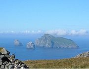
Highest islands
- See also List of Munros and List of Marilyns on Scottish islands
Scotland's islands include thirteen Munro
Munro
A Munro is a mountain in Scotland with a height over . They are named after Sir Hugh Munro, 4th Baronet , who produced the first list of such hills, known as Munros Tables, in 1891. A Munro top is a summit over 3,000 ft which is not regarded as a separate mountain...
s (mountains with a height over 3,000 feet or 914.4 metres), twelve of them found on Skye, and a total of 227 Marilyns
Marilyn (hill)
A Marilyn is a mountain or hill in the United Kingdom, Republic of Ireland or Isle of Man with a relative height of at least 150 metres , regardless of absolute height or other merit...
(hills with a relative height
Topographic prominence
In topography, prominence, also known as autonomous height, relative height, shoulder drop , or prime factor , categorizes the height of the mountain's or hill's summit by the elevation between it and the lowest contour line encircling it and no higher summit...
of at least 150 metres, regardless of absolute height
Elevation
The elevation of a geographic location is its height above a fixed reference point, most commonly a reference geoid, a mathematical model of the Earth's sea level as an equipotential gravitational surface ....
). The following list is of all islands with a highest elevation greater than 300 metres (984.3 ft).

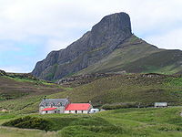
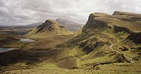
| Rank | Island | Mountain | Height (ft) | Height (m) |
|---|---|---|---|---|
| 1 | Skye Skye Skye or the Isle of Skye is the largest and most northerly island in the Inner Hebrides of Scotland. The island's peninsulas radiate out from a mountainous centre dominated by the Cuillin hills... |
Sgurr Alasdair Sgurr Alasdair Sgurr Alasdair is the highest peak of the Black Cuillin, and the highest peak on the Isle of Skye. Like the rest of the range it is composed of gabbro, a rock with excellent grip for mountaineering.-Ascent:... |
3,258 | 993 |
| 2 | Mull Isle of Mull The Isle of Mull or simply Mull is the second largest island of the Inner Hebrides, off the west coast of Scotland in the council area of Argyll and Bute.... |
Ben More Ben More (Mull) Ben More is the highest mountain and only Munro on the Isle of Mull, Scotland.... |
3,169 | 966 |
| 3 | Arran Isle of Arran Arran or the Isle of Arran is the largest island in the Firth of Clyde, Scotland, and with an area of is the seventh largest Scottish island. It is in the unitary council area of North Ayrshire and the 2001 census had a resident population of 5,058... |
Goat Fell Goat Fell Goat Fell is the highest point on the Isle of Arran. At 874 metres , it is one of four Corbetts on the island... |
2,867 | 874 |
| 4 | Rùm Rùm Rùm , a Scottish Gaelic name often anglicised to Rum) is one of the Small Isles of the Inner Hebrides, in the district of Lochaber, Scotland... |
Askival Askival Askival is the highest mountain on the island of Rùm, located south of the town of Kinloch, Scotland. It is often climbed as part of a full traverse of the Rùm Cuillin, a rocky range of hills in the south east corner of Rùm, of which Askival is the highest.... |
2,664 | 812 |
| 5 | Lewis and Harris Lewis and Harris Lewis and Harris in the Outer Hebrides make up the largest island in Scotland. This is the largest single island of the British Isles after Great Britain and Ireland.-Geography:... |
Clisham Clisham The Clisham is a mountain on the island of Harris in the Western Isles of Scotland. At it is the highest mountain in the Outer Hebrides and the archipelago's only Corbett.... |
2,621 | 799 |
| 6 | Jura Jura, Scotland Jura is an island in the Inner Hebrides of Scotland, situated adjacent and to the north-east of Islay. Part of the island is designated as a National Scenic Area. Until the twentieth century Jura was dominated - and most of it was eventually owned - by the Campbell clan of Inveraray Castle on Loch... |
Beinn an Òir Beinn an Oir Beinn an Òir is the highest peak of the Paps of Jura on the island of Jura, Scotland. It is the highest peak on the island, standing at 785 metres, and is thereby a Corbett.... |
2,575 | 785 |
| 7 | South Uist South Uist South Uist is an island of the Outer Hebrides in Scotland. In the 2001 census it had a usually resident population of 1,818. There is a nature reserve and a number of sites of archaeological interest, including the only location in Great Britain where prehistoric mummies have been found. The... |
Beinn Mhòr | 2,034 | 620 |
| 8 | Islay Islay -Prehistory:The earliest settlers on Islay were nomadic hunter-gatherers who arrived during the Mesolithic period after the retreat of the Pleistocene ice caps. In 1993 a flint arrowhead was found in a field near Bridgend dating from 10,800 BC, the earliest evidence of a human presence found so far... |
Beinn Bheigier | 1,610 | 491 |
| 9 | Hoy Hoy Hoy is an island in Orkney, Scotland. With an area of it is the second largest in the archipelago after the Mainland. It is connected by a causeway called The Ayre to South Walls... |
Ward Hill Ward Hill, Hoy Ward Hill, on the island of Hoy, is the highest hill in Orkney, Scotland. It lies at the north of the island, between Moaness and Rackwick.The hill forms a curved ridge, reminiscent of a 'J' in shape. The lower slopes are covered in heather and grass, though the top of the ridge is covered in small... |
1,571 | 479 |
| 10 | Shetland Mainland Shetland Mainland The Mainland is the main island of Shetland, Scotland. The island contains Shetland's only burgh, Lerwick, and is the centre of Shetland's ferry and air connections.... |
Ronas Hill Ronas Hill Ronas Hill is a Marilyn, the highest point of Mainland, Shetland, in Scotland. There is a Neolithic chambered cairn near the summit.-Location:... |
1,476 | 450 |
| 11 | Scarba Scarba Scarba is a small island, in Argyll and Bute, Scotland, just north of the much larger island of Jura. The island is owned by Richard Hill, 7th Baron Sandys and has not been permanently inhabited since the 1960s. It is now covered in heather and used for grazing animals... |
Cruach Scarba | 1,473 | 449 |
| 12 | Raasay Raasay Raasay is an island between the Isle of Skye and the mainland of Scotland. It is separated from Skye by the Sound of Raasay and from Applecross by the Inner Sound. It is most famous for being the birthplace of the poet Sorley MacLean, an important figure in the Scottish literary renaissance... |
Dùn Caan | 1,453 | 443 |
| 13 | Hirta Hirta Hirta is the largest island in the St Kilda archipelago, on the western edge of Scotland. The name "Hiort" and "Hirta" have also been applied to the entire archipelago.-Geography:... |
Conachair | 1,410 | 430 |
| 14 | Foula Foula Foula in the Shetland Islands of Scotland is one of Great Britain’s most remote permanently inhabited islands. Owned since the turn of the 20th century by the Holbourn family, the island was the location for the film The Edge of the World... |
The Sneug | 1,371 | 418 |
| 15 | Eigg Eigg Eigg is one of the Small Isles, in the Scottish Inner Hebrides. It lies to the south of the Skye and to the north of the Ardnamurchan peninsula. Eigg is long from north to south, and east to west. With an area of , it is the second largest of the Small Isles after Rùm.-Geography:The main... |
An Sgurr An Sgurr (Eigg) An Sgurr is the highest hill on the Inner Hebridean island of Eigg, Lochaber, Highland, Scotland. It was formed around 58 million years ago; the result of one of the last eruptions of a volcano, the core of which now forms the Isle of Rùm. Thick viscous pitchstone lava flowed out, filling a river... |
1,289 | 393 |
| 16 | Scalpay, Inner Hebrides Scalpay, Inner Hebrides Scalpay is an island in the Inner Hebrides of Scotland.Separated from the east coast of Skye by Loch na Cairidh, Scalpay rises to at Mullach na Càrn. It has an area of almost ten sq. miles.... |
Mullach na Càrn | 1,286 | 392 |
| 17 | Boreray, St Kilda Boreray, St Kilda Boreray is an uninhabited island in the St Kilda archipelago in the North Atlantic.-Geography:Boreray lies about 66 km west-north-west of North Uist. It covers about , and reaches a height of at Mullach an Eilein.... |
Mullach an Eilein | 1,259 | 384 |
| 18 | Barra Barra The island of Barra is a predominantly Gaelic-speaking island, and apart from the adjacent island of Vatersay, to which it is connected by a causeway, is the southernmost inhabited island of the Outer Hebrides in Scotland.-Geography:The 2001 census showed that the resident population was 1,078... |
Heaval Heaval Heaval is the highest hill on the island of Barra, Scotland. It is 383 metres tall and is located 1.5km northeast of Castlebay.It is most easily ascended from the south east, from the top of a 102 m road pass about 1 km north east of Castlebay. There is signposted car park nearby. About half way up... |
1,256 | 383 |
| 19 | Soay, St Kilda Soay, St Kilda Soay is an uninhabited islet in the St Kilda archipelago, Scotland. The island is part of the St Kilda World Heritage Site and home to a primitive breed of sheep... |
Cnoc Glas | 1,240 | 378 |
| 20 | North Uist North Uist North Uist is an island and community in the Outer Hebrides of Scotland.-Geography:North Uist is the tenth largest Scottish island and the thirteenth largest island surrounding Great Britain. It has an area of , slightly smaller than South Uist. North Uist is connected by causeways to Benbecula... |
Eavel | 1,138 | 347 |
| 21 | Ailsa Craig Ailsa Craig Ailsa Craig is an island of 219.69 acres in the outer Firth of Clyde, Scotland where blue hone granite was quarried to make curling stones. "Ailsa" is pronounced "ale-sa", with the first syllable stressed... |
The Cairn | 1,108 | 338 |
| 22 | Holy Isle Holy Isle, Firth of Clyde The Holy Isle, Firth of Clyde is one of a number of islands in the United Kingdom which go under the name "Holy Island". It is located in the Firth of Clyde off the west coast of central Scotland, inside Lamlash Bay on the larger island of Arran.- Details :The island is around long and around ... |
Mullach Mòr Holy Isle, Firth of Clyde The Holy Isle, Firth of Clyde is one of a number of islands in the United Kingdom which go under the name "Holy Island". It is located in the Firth of Clyde off the west coast of central Scotland, inside Lamlash Bay on the larger island of Arran.- Details :The island is around long and around ... |
1,030 | 314 |
| 23 | Ulva Ulva Ulva is an island in the Inner Hebrides of Scotland, off the west coast of Mull. It is separated from Mull by a narrow strait, and connected to the neighbouring island of Gometra by a bridge. Much of the island is formed from Tertiary basalt rocks, which is formed into columns in places.Ulva has... |
Beinn Creagach | 1,026 | 313 |
| 24 | Scarp Scarp, Scotland Scarp is an uninhabited island in the Outer Hebrides of Scotland, west of Hushinish on Harris. Once inhabited, the island was the scene of unsuccessful experiments with rocket mail, since commemorated in two films.-Geography:... |
Sròn Romul | 1,010 | 308 |
Former islands
The following is a list of places which were formerly islands, but which are no longer so due to silting up, harbour building etc.- Broch of Clickimin is a former island in Loch of Clickimin, LerwickLerwickLerwick is the capital and main port of the Shetland Islands, Scotland, located more than 100 miles off the north coast of mainland Scotland on the east coast of the Shetland Mainland...
, in Shetland. Originally an offshore island, the loch became cut off from the sea around 200 BC and the island is now connected to dry land by a permanent causeway. - Bunglan was once a separate island, but is now connected to SamphreySamphreyleft|thumb|Samphrey and the view down [[Yell Sound]]Samphrey is an uninhabited island in the Shetland Islands, Scotland. One of Fair Isle's old names is "Friðarey" which is of similar origin....
by two tomboloTomboloA tombolo, from the Italian tombolo, derived from the Latin tumulus, meaning 'mound,' and sometimes translated as ayre , is a deposition landform in which an island is attached to the mainland by a narrow piece of land such as a spit or bar. Once attached, the island is then known as a tied island...
s. - Eilean-a-beithichEilean-a-beithichEilean-a-beithich was once one of the Slate Islands, located in Easdale Sound between Easdale and Seil, in the Inner Hebrides....
was once one of the Slate IslandsSlate IslandsThe Slate Islands are an island group in the Inner Hebrides, lying immediately off the west coast of Scotland, north of Jura and southwest of Oban. The main islands are Seil, Easdale, Luing, Lunga, Shuna, Torsa and Belnahua...
and located in Easdale Sound. However, it was quarried to a depth of 76 metres (249.3 ft) below sea level leaving only the outer rim of the island. This was eventually swept away by the sea and little visible sign of the island now remains. - Eilean Chaluim Chille is a former island near Kilmuir on Skye in a now drained loch that was associated with the 13th century Hebridean lord Páll, son of Bálki.
- Inchbroach, also known as Rossie Island, is now part of MontroseMontrose, AngusMontrose is a coastal resort town and former royal burgh in Angus, Scotland. It is situated 38 miles north of Dundee between the mouths of the North and South Esk rivers...
harbour. - Inch of Culter is a former island in the River DeeRiver Dee, AberdeenshireThe River Dee is a river in Aberdeenshire, Scotland. It rises in the Cairngorms and flows through Strathdee to reach the North Sea at Aberdeen...
near MaryculterMaryculterMaryculter or Kirkton of Maryculter is a village in the Lower Deeside area of Aberdeenshire, Scotland. The River Dee separates it from the town of Peterculter, and the B979 road runs through Maryculter. There are two hotels: The Old Mill Inn, a former coaching inn that dates back 200 years, and...
. - Innis Bheag or Paterson Island near PortmahomackPortmahomackPortmahomack is a small fishing village in Easter Ross, Scotland. It is situated in the Tarbat Peninsula in the parish of Tarbat. Tarbat Ness Lighthouse is about three miles from the village at the end of the Tarbat Peninsula. Ballone Castle lies about a mile from the village...
in Easter Ross is now permanently attached to the Morrich MoreMorrich MoreMorrich More is an extensive area of dune grassland with wetland communities, on the southern shore of the Dornoch Firth, Scotland.Morrich More lies east of Tain, on the southern shore of the Dornoch Firth, Scotland. Offshore lie extensive areas of intertidal sandflat, including the tidal island of...
due to shifting sands. - Keith InchKeith InchNot to be confused with "Inchkeith", in the Firth of ForthKeith Inch is the easternmost point of mainland Scotland.It is located in Peterhead in Aberdeenshire, forming the north point of Peterhead Bay at ....
(not to be confused with InchkeithInchkeithInchkeith is an island in the Firth of Forth, Scotland. It is part of the council area of Fife.Inchkeith has had a colourful history as a result of its proximity to Edinburgh and strategic location for use as home for a lighthouse and for military purposes defending the Firth of Forth for attack...
), is now part of Peterhead HarbourPeterheadPeterhead is a town in Aberdeenshire, Scotland. It is Aberdeenshire's biggest settlement , with a population of 17,947 at the 2001 Census and estimated to have fallen to 17,330 by 2006....
, and is the easternmost pointExtreme points of the United KingdomThis is a list of the extreme points of the United Kingdom: the points that are farther north, south, east or west than any other location. Traditionally the extent of the island of Great Britain has stretched "from Land's End to John o' Groats" .This article does not include references to the...
of mainland ScotlandScotlandScotland is a country that is part of the United Kingdom. Occupying the northern third of the island of Great Britain, it shares a border with England to the south and is bounded by the North Sea to the east, the Atlantic Ocean to the north and west, and the North Channel and Irish Sea to the...
. - King's Inch, on which stood Renfrew CastleRenfrew CastleRenfrew Castle was a castle situated near junction of the River Clyde and White Cart upon the former river islet, known as the King's Inch, at Renfrew, Renfrewshire, Scotland...
. - North InchBattle of the North InchThe Battle of the North Inch was a staged battle between the Chattan Confederation and the "Clan Kay" in September 1396...
, one of the "Inches" in PerthPerth, ScotlandPerth is a town and former city and royal burgh in central Scotland. Located on the banks of the River Tay, it is the administrative centre of Perth and Kinross council area and the historic county town of Perthshire...
, formerly an island in the River TayRiver TayThe River Tay is the longest river in Scotland and the seventh-longest in the United Kingdom. The Tay originates in western Scotland on the slopes of Ben Lui , then flows easterly across the Highlands, through Loch Dochhart, Loch Lubhair and Loch Tay, then continues east through Strathtay , in...
. - Rosyth CastleRosyth CastleRosyth Castle is a fifteenth century ruined tower house on the perimeter of Rosyth Naval Dockyard, Fife, Scotland.It originally stood on a small island in the Firth of Forth accessible only at low tide, and dates from around 1450, built as a secure residence by Sir David Stewart, who had been...
also stands on what was once a tidal island in the Firth of ForthFirth of ForthThe Firth of Forth is the estuary or firth of Scotland's River Forth, where it flows into the North Sea, between Fife to the north, and West Lothian, the City of Edinburgh and East Lothian to the south...
, now surrounded by reclaimed land. - Preston IslandPreston Island, FifePreston Island is a former artificial island in the Firth of Forth, Scotland. The reclaimed land was once used for salt production, using local coal. It is part of Fife.-History:...
, an artificial construction south of Low Valleyfield, has now been fully reclaimed, using ash slurry from Longannet power stationLongannet power stationLongannet power station is a large coal-fired power station in Fife capable of co-firing biomass, natural gas and sludge. The station is situated on the north bank of the Firth of Forth, near Kincardine on Forth. Its generating capacity of 2,400 megawatts is the highest of any power station in...
. - Viking Bergen IslandViking Bergen IslandViking Bergen is the name of a hypothetical former island between modern Shetland and Norway, at the boundary of the North Sea, and Norwegian Sea. The area is now known as the "Viking-Bergen banks"....
, a sunken island of the early HoloceneHoloceneThe Holocene is a geological epoch which began at the end of the Pleistocene and continues to the present. The Holocene is part of the Quaternary period. Its name comes from the Greek words and , meaning "entirely recent"...
. - WhiteinchWhiteinchWhiteinch is a district in the Scottish city of Glasgow. It is situated north of the River Clyde between the Partick and Scotstoun areas of the city...
, now an area of GlasgowGlasgowGlasgow is the largest city in Scotland and third most populous in the United Kingdom. The city is situated on the River Clyde in the country's west central lowlands...
.
Bridged islands
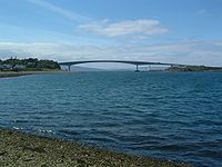
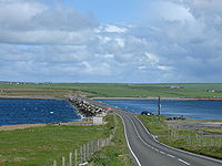
Outer Hebrides
Many of the islands of the southern Outer Hebrides have been joined to other islands by causeways and bridges. These include:
- BaleshareBaleshareBaleshare is a flat tidal island in the Outer Hebrides of Scotland.Baleshare lies to the south-west of North Uist. Its economics and community were boosted by the building of a causeway in 1962. The 350m causeway was built by William Tawse Ltd. The island is extremely flat by Hebridean standards,...
- BenbeculaBenbeculaBenbecula is an island of the Outer Hebrides in the Atlantic Ocean off the west coast of Scotland. In the 2001 census it had a usually resident population of 1,249, with a sizable percentage of Roman Catholics. It forms part of the area administered by Comhairle nan Eilean Siar or the Western...
- BernerayBerneray, North UistBerneray is an island and community in the Sound of Harris, Scotland. It is one of fifteen inhabited islands in the Outer Hebrides. It is famed for its rich and colourful history which has attracted much tourism....
- EriskayEriskayEriskay , from the Old Norse for "Eric's Isle", is an island and community council area of the Outer Hebrides in northern Scotland. It lies between South Uist and Barra and is connected to South Uist by a causeway which was opened in 2001. In the same year Eriskay became the ferry terminal for...
- GrimsayGrimsayGrimsay is a tidal island in the Outer Hebrides of Scotland.Grimsay is the largest of the low-lying stepping-stones which convey the Oitir Mhòr causeway, a five mile arc of single track road linking North Uist and Benbecula via the western tip of Grimsay...
- North UistNorth UistNorth Uist is an island and community in the Outer Hebrides of Scotland.-Geography:North Uist is the tenth largest Scottish island and the thirteenth largest island surrounding Great Britain. It has an area of , slightly smaller than South Uist. North Uist is connected by causeways to Benbecula...
- South UistSouth UistSouth Uist is an island of the Outer Hebrides in Scotland. In the 2001 census it had a usually resident population of 1,818. There is a nature reserve and a number of sites of archaeological interest, including the only location in Great Britain where prehistoric mummies have been found. The...
- VatersayVatersayVatersay is an inhabited island in the Outer Hebrides of Scotland. Vatersay is also the name of the only village on the island.-Location:The westernmost permanently inhabited place in Scotland, Vatersay is linked to Barra by a causeway completed in 1991...
(joined to BarraBarraThe island of Barra is a predominantly Gaelic-speaking island, and apart from the adjacent island of Vatersay, to which it is connected by a causeway, is the southernmost inhabited island of the Outer Hebrides in Scotland.-Geography:The 2001 census showed that the resident population was 1,078...
, but not to the above islands)
To the north, Scalpay
Scalpay, Outer Hebrides
Scalpay to distinguish it from the other Scalpay) is an island and community in the Outer Hebrides of Scotland.-Geography:Scalpay is around 2.5 miles long and rises to a height of 341 ft at Beinn Scorabhaig. Scalpay's nearest neighbour, Harris is just 330 yds away over narrow Caolas...
and Great Bernera
Great Bernera
Great Bernera , often known just as Bernera is an island and community in the Outer Hebrides of Scotland. With an area of just over , it is the thirty-fourth largest Scottish island....
are connected to Lewis and Harris
Lewis and Harris
Lewis and Harris in the Outer Hebrides make up the largest island in Scotland. This is the largest single island of the British Isles after Great Britain and Ireland.-Geography:...
.
Inner Hebrides
- The Isle of Skye is connected to the mainland by the Skye BridgeSkye BridgeThe Skye Bridge is a road bridge over Loch Alsh, connecting mainland Highland with the Isle of Skye, Scotland. It forms part of the A87. The bridge is located at around , with one pillar standing on the island of Eilean Bàn....
which now incorporates Eilean Bàn. - Eilean DonanEilean DonanEilean Donan is a small island in Loch Duich in the western Highlands of Scotland. It is connected to the mainland by a footbridge and lies about half a mile from the village of Dornie. Eilean Donan is named after Donnán of Eigg, a Celtic saint martyred in 617...
(to mainland) - EriskaEriskaEriska is a flat, tidal island at the entrance to Loch Creran on the west coast of Scotland. Privately owned, the island is run as a hotel with wooded grounds. The island is evidently populated although no record for the total was provided by the 2001 census....
(to mainland) - SeilSeilOne of the Slate Islands, Seil is a small island on the east side of the Firth of Lorn, southwest of Oban, in Scotland.Seil has been linked to the Scottish mainland since 1792 when the Clachan Bridge was built by engineer Robert Mylne...
(to mainland) via Telford'sThomas TelfordThomas Telford FRS, FRSE was a Scottish civil engineer, architect and stonemason, and a noted road, bridge and canal builder.-Early career:...
1792 "Bridge across The AtlanticClachan BridgeThe Clachan Bridge is a simple, single-arched, hump-backed masonry bridge spanning the Clachan Sound, miles southwest of Oban in Argyll, Scotland....
".
Orkney Islands

Causeway
In modern usage, a causeway is a road or railway elevated, usually across a broad body of water or wetland.- Etymology :When first used, the word appeared in a form such as “causey way” making clear its derivation from the earlier form “causey”. This word seems to have come from the same source by...
s known as the Churchill Barriers
Churchill Barriers
The Churchill Barriers are a series of four causeways in the Orkney Islands, Scotland, with a total length of 1.5 miles . They link the Orkney Mainland in the north to the island of South Ronaldsay via Burray and the two smaller islands of Lamb Holm and Glimps Holm.The barriers were built in the...
. They are:
- South RonaldsaySouth RonaldsaySouth Ronaldsay is one of the Orkney Islands off the north coast of Scotland. It is linked to the Orkney Mainland by the Churchill Barriers, running via Burray, Glimps Holm and Lamb Holm.-Geography and geology:...
- BurrayBurrayBurray is one of the Orkney Islands in Scotland. It lies to the east of Scapa Flow and is one of a chain of islands linked by the Churchill Barriers.-Geography and geology:...
- Lamb HolmLamb HolmLamb Holm is a small uninhabited island in Orkney, Scotland. The remarkable Italian Chapel, constructed during the Second World War, is the island's main attraction.-Geography:...
- Glims HolmGlims HolmGlims Holm is a small uninhabited islet in Orkney, Scotland.-Geography:Glims Holm lies in Holm Sound, one of the eastern entrances to Scapa Flow, between Mainland, Orkney and the island of Burray, The Churchill Barriers link South Ronaldsay to the Orkney Mainland...
Hunda
Hunda
Hunda is an uninhabited island in the Orkney archipelago in Scotland. It is in extent and rises to above sea level. It is situated in the Scapa Flow and connected to the nearby island of Burray by a causeway built in 1941 to stop passage of small surface craft as part of the boom defences, and...
is in turn connected to Burray via a causeway.
South Walls
South Walls
South Walls is an inhabited island adjacent to Hoy in Orkney, Scotland. The name is a corruption of "Sooth Was", which means the "southern voes" - as with Kirkwall, it was assumed that it was a mispronunciation of "walls"....
and Hoy
Hoy
Hoy is an island in Orkney, Scotland. With an area of it is the second largest in the archipelago after the Mainland. It is connected by a causeway called The Ayre to South Walls...
are connected by a causeway called the Ayre. The islands are treated as one entity (Hoy) by the UK census.
An undersea tunnel between the archipelago and Caithness
Caithness
Caithness is a registration county, lieutenancy area and historic local government area of Scotland. The name was used also for the earldom of Caithness and the Caithness constituency of the Parliament of the United Kingdom . Boundaries are not identical in all contexts, but the Caithness area is...
, at a length of about 9–10 mi (14.5–16.1 km) and a tunnel connecting Orkney Mainland to Shapinsay have been discussed, although little has come of it.
Shetland Islands
Several Shetland islands are joined to the Shetland Mainland:
- West Burra and East BurraEast BurraEast Burra is one of the Scalloway Islands, a subgroup of the Shetland Islands in Scotland. It is connected by a bridge to West Burra.With an area of two square miles, it is the eleventh largest of the Shetland Islands....
(via Trondra) - Muckle RoeMuckle RoeMuckle Roe is an island in Shetland, Scotland, in Saint Magnus Bay, to the west of Mainland, Shetland. It has a population of around 100 people, who mainly croft and live in the south east of the island...
- TrondraTrondraTrondra is one of the Scalloway Islands, a subgroup of the Shetland Islands in Scotland. It shelters the harbour of Scalloway and has an area of .-History:...
- Broch of Clickimin is a freshwater islet joined to the mainland by a stone causeway.
There is also a bridge from Housay
Housay
Housay, also known as West Isle, is one of the three islands that form the Out Skerries island group, the most easterly part of the Shetland Isles...
to Bruray
Bruray
Bruray is one of the three Out Skerries islands of Shetland, and contains Scotland's most easterly settlement.It is separated from Housay by North Mouth and South Mouth.-Infrastructure:...
.
Others
Various other islands are also connected by bridges or causeways, to the mainland or other islands, including:
- InchgarvieInchgarvieInchgarvie is a small, uninhabited island in the Firth of Forth. Its name comes from Innis Garbhach which is Scottish Gaelic for "rough island"...
(part of Forth BridgeForth Bridge (railway)The Forth Bridge is a cantilever railway bridge over the Firth of Forth in the east of Scotland, to the east of the Forth Road Bridge, and 14 kilometres west of central Edinburgh. It was opened on 4 March 1890, and spans a total length of...
), thus joined to both FifeFifeFife is a council area and former county of Scotland. It is situated between the Firth of Tay and the Firth of Forth, with inland boundaries to Perth and Kinross and Clackmannanshire...
and LothianLothianLothian forms a traditional region of Scotland, lying between the southern shore of the Firth of Forth and the Lammermuir Hills....
on the Mainland. - Garbh Eilean at the entrance to Loch Glencoul is now joined to the mainland by both the Kylesku Bridge to the south and its associated roadworks to the north.
- Innis Chonan, an inhabited island in Loch AweLoch AweLoch Awe is a large body of water in Argyll and Bute, Scotland. It has also given its name to a village on its banks, variously known as Loch Awe, or Lochawe. There are islands within the loch such as Innis Chonnell and Inishail.- The loch :It is the third largest freshwater loch in Scotland with...
is connected to the mainland by a small road bridge.
Tidal islands and tombolos
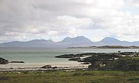
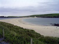
- BaleshareBaleshareBaleshare is a flat tidal island in the Outer Hebrides of Scotland.Baleshare lies to the south-west of North Uist. Its economics and community were boosted by the building of a causeway in 1962. The 350m causeway was built by William Tawse Ltd. The island is extremely flat by Hebridean standards,...
- BerneraBernera, LismoreBernera Island is a tidal island off Lismore, in Argyll, Scotland.-History:In the 6th Century, Bernera was settled by monks of the Irish Culdee church under the leadership of St. Moluag. St. Columba used the island as a private place for retreat, meditation and prayer, and may have preached under ...
- Calve IslandCalve IslandCalve Island is an uninhabited island on the east coast of the Isle of Mull in Argyll and Bute on the west coast of Scotland. It provides some shelter for Tobermory Bay and is separated from Mull by a tidal channel. The island is a mile in length...
- Castle IslandCastle Island, ScotlandCastle Island or Allimturrail is a small tidal island, lying off the east coast of Little Cumbrae, and to the west of Trail Island, in the Firth of Clyde. It is joined to Little Cumbrae at low tide....
- Corn HolmCorn HolmCorn Holm is a small tidal island in Orkney, near Copinsay to the west. There was once a small chapel here , and it is covered in birdlife.- Geography and geology :Corn Holm is made up of red sandstone....
- Cramond IslandCramond IslandCramond Island is one of several islands that lie in the Firth of Forth in eastern Scotland, near Edinburgh. As its name implies, it lies off Cramond. It is long and covers , and is currently part of the Dalmeny Estate.Strictly speaking it is not a true island at all, but a tidal island being...
- DannaDanna, ScotlandDanna Island is a tidal island in Argyll and Bute. It is connected to the mainland by a stone causeway and is at the southern end of the narrow Tayvallich peninsula, which separates Loch Sween from the Sound of Jura. It is part of the Ulva, Danna and the MacCormaig Isles SSSI. Danna is part of the...
- Davaar IslandDavaar IslandDavaar Island or Island Davaar is located at the mouth of Campbeltown Loch off the east coast of Kintyre, in Argyll and Bute, Scotland. It is a tidal island, linked to the mainland by a natural shingle causeway called the Dhorlin near Campbeltown at low tide...
- Eilean Mhic ChrionEilean Mhic ChrionEilean Mhic Chrion is a tidal island sheltering Ardfern in Loch Craignish, Scotland....
- Eilean ShonaEilean ShonaEilean Shona is a tidal island in Loch Moidart, Scotland. The earlier Gaelic names was Arthraigh, meaning 'foreshore island', similar to the derivation of Erraid....
- EriskaEriskaEriska is a flat, tidal island at the entrance to Loch Creran on the west coast of Scotland. Privately owned, the island is run as a hotel with wooded grounds. The island is evidently populated although no record for the total was provided by the 2001 census....
- ErraidErraidThe Isle of Erraid is a tidal island approximately one mile square in area located in the Inner Hebrides of Scotland. It lies west of Mull and southeast of Iona. The island receives about of rain and 1,350 hours of sunshine annually, making it one of the driest and sunniest places on the western...
- Helliar HolmHelliar HolmHelliar Holm is an uninhabited island off the coast of Shapinsay in the Orkney Islands, Scotland. It is home to a lighthouse, which was built in 1893 and automated in 1967...
- Kili HolmKili HolmKili Holm is a tidal island in the Orkney Islands, linked to Egilsay. Unusually, like its neighbour Egilsay, it may have a partly Gaelic etymology, in this case from cille meaning a monk’s cell...
- Isle RistolIsle RistolIsle Ristol, the innermost of the Summer Isles in Scotland, is a Scottish Wildlife Trust Reserve.Lying roughly north of Ullapool in Wester Ross, it is a tidal island, in Loch an Alltain Duibh, that is separated by a narrow channel from Old Dorney Bay...
- SandaySanday, Inner HebridesSanday is one of the Small Isles, in the Scottish Inner Hebrides. It is a tidal island linked to its larger neighbor, Canna, via sandbanks at low tide, and also connected to the larger island by a bridge...
- TorsaTorsaTorsa is one of the Slate Islands in Argyll and Bute, Scotland.Lying east of Luing and south of Seil, the island was inhabited until the 1960s. There is now only one house on the island, which is used for holiday lets. Its main industry is farming, with cattle brought over from the neighbouring...
Oronsay
Oronsay
This is a list of islands called Oronsay , which provides an index for islands in Scotland with this and similar names. It is one of the more common names for Scottish islands. The names come from Örfirisey which translates from Old Norse as "tidal" or "ebb island"...
means "ebb island" and there are several tidal islands of this name.
The three main islands of the Monach Islands
Monach Islands
Not to be confused with Heysker/Hyskeir or HaskeirThe Monach Islands, also known as Heisker , are an island group west of North Uist in the Outer Hebrides of Scotland...
(Heisgeir), Ceann Iar
Ceann Iar
Disambiguation: "Ceann Iar" is a common Scottish placename meaning Western HeadlandCeann Iar is one of the Monach Isles/Heisgeir, to the west of North Uist in the Outer Hebrides. It is a slender island, approximately a mile, or two kilometres long.-Geography:Ceann Iar is the second largest of the...
, Ceann Ear
Ceann Ear
Disambiguation: "Ceann Ear" is a common Scottish placename meaning Eastern HeadlandCeann Ear is the largest island in the Monach or Heisgeir group off North Uist in north west Scotland. It is in size and connected by sandbanks to Ceann Iar via Sibhinis at low tide. It is said that it was at one...
and Shivinish are connected at low tides. It is said that at one time it was also possible to walk all the way to Baleshare
Baleshare
Baleshare is a flat tidal island in the Outer Hebrides of Scotland.Baleshare lies to the south-west of North Uist. Its economics and community were boosted by the building of a causeway in 1962. The 350m causeway was built by William Tawse Ltd. The island is extremely flat by Hebridean standards,...
, and on to North Uist
North Uist
North Uist is an island and community in the Outer Hebrides of Scotland.-Geography:North Uist is the tenth largest Scottish island and the thirteenth largest island surrounding Great Britain. It has an area of , slightly smaller than South Uist. North Uist is connected by causeways to Benbecula...
, five miles away at low tide. In the 16th century, a large tidal wave was said to have washed the route away.
St Ninian's Isle
St Ninian's Isle
St Ninian's Isle is a small island connected by the largest active tombolo in the UK to the south-western coast of the Mainland, Shetland, in Scotland. The tombolo, known locally as an ayre, from the Old Norse for 'gravel bank', is 500 metres long. Except at extremely high tides, the sand is above...
is connected to Mainland Shetland by a tombolo
Tombolo
A tombolo, from the Italian tombolo, derived from the Latin tumulus, meaning 'mound,' and sometimes translated as ayre , is a deposition landform in which an island is attached to the mainland by a narrow piece of land such as a spit or bar. Once attached, the island is then known as a tied island...
. Although greater than 40 hectares in size it fails to meet the definition of an island used in this list as it is only surrounded by water during occasional spring tides and storms.
Dùn
Dùn, St Kilda
Dùn is an island in the St Kilda archipelago. It is nearly a mile long. Its name simply means "fort" in Scottish Gaelic , but the fort itself has been lost - old maps show it on Gob an Dùin , which is at the seaward end.Almost joined to Hirta at Ruiaval, the two islands are separated by Caolas an...
in St Kilda
St Kilda, Scotland
St Kilda is an isolated archipelago west-northwest of North Uist in the North Atlantic Ocean. It contains the westernmost islands of the Outer Hebrides of Scotland. The largest island is Hirta, whose sea cliffs are the highest in the United Kingdom and three other islands , were also used for...
is separated from Hirta
Hirta
Hirta is the largest island in the St Kilda archipelago, on the western edge of Scotland. The name "Hiort" and "Hirta" have also been applied to the entire archipelago.-Geography:...
by a shallow strait about 50 metres wide. This is normally impassable but is reputed to dry out on rare occasions.
Castle Islands
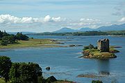
- Bass RockBass RockThe Bass Rock, or simply The Bass, , is an island in the outer part of the Firth of Forth in the east of Scotland. It is approximately offshore, and north-east of North Berwick. It is a steep-sided volcanic rock, at its highest point, and is home to a large colony of gannets...
- Broch of West Burrafirth
- Castle IslandCastle Island, ScotlandCastle Island or Allimturrail is a small tidal island, lying off the east coast of Little Cumbrae, and to the west of Trail Island, in the Firth of Clyde. It is joined to Little Cumbrae at low tide....
- CalvayCalvayCalvay , is an uninhabited island situated in the Sound of Eriskay in the Outer Hebrides.It was here that the ship SS Politician ran aground with a cargo of whisky in 1941 and inadvertently provided the inspiration for Compton MacKenzie's 1947 novel Whiskey Galore.-Other uses:A second island of the...
- Castle StalkerCastle StalkerCastle Stalker is a four-storey tower house or keep picturesquely set on a tidal islet on Loch Laich, an inlet off Loch Linnhe. It is located about north east of Port Appin, Argyll, Scotland, and is visible from the A828 road around mid-way between Oban and Glen Coe. The islet is accessible from...
- Castle TioramCastle TioramCastle Tioram is a ruined castle that sits on the tidal island Eilean Tioram in Loch Moidart, Lochaber, Highland, Scotland. It is located west of Acharacle, approximately 80 kilometres from Fort William...
- Eilean AigasEilean AigasEilean Aigas is an island in the River Beauly, Scotland, in Kiltarlity parish in traditional Inverness-shire, now Highland Region. It is most notable for the mansion on it at its north end, which was formerly owned by the Sobieski Stuarts and rented by author and Scottish nationalist Compton...
(F) - Eilean Dearg, Loch RiddonEilean Dearg, Loch RiddonEilean Dearg is a small island in Loch Riddon. The island was once home to a castle, which was destroyed by naval action in Argyll's Rising in 1685. No visible remains of the castle are to be found, but archaeologists excavated the site between 1964 and 1967, finding the castle's hall, chapel, a...
- Eilean DonanEilean DonanEilean Donan is a small island in Loch Duich in the western Highlands of Scotland. It is connected to the mainland by a footbridge and lies about half a mile from the village of Dornie. Eilean Donan is named after Donnán of Eigg, a Celtic saint martyred in 617...
- InchtallaInchtallaInchtalla or Inch Talla is an island in the Lake of Menteith, central Scotland....
(F) - Inveruglas IsleInveruglas IsleInveruglas Isle is a small island within Loch Lomond, and lies off the shore at Inveruglas opposite Inversnaid at the north end of the loch. It is opposite the Loch Sloy powerstation...
(F) - Kilchurn CastleKilchurn CastleKilchurn Castle is a ruined 15th century structure on the northeastern end of Loch Awe, in Argyll and Bute, Scotland.It was the ancestral home of the Campbells of Glen Orchy, who later became the Earls of Breadalbane also known as the Breadalbane family branch, of the Clan Campbell. The earliest...
(F) - Kisimul CastleKisimul CastleKisimul Castle is a small medieval castle located in the centre of Castlebay on Barra, an island of the Outer Hebrides, Scotland....
- Lochindorb CastleLochindorbLochindorb is a freshwater loch north of Grantown on Spey in the Highland council area of Scotland. This loch is home to the ruins of Lochindorb Castle, a former stronghold of the Clan Comyn. It is also a popular spot with fishers and birdwatchers, the latter of whom come to see the local...
(F) - Loch Leven CastleLoch Leven CastleLoch Leven Castle is a ruined castle on an island in Loch Leven, in the Perth and Kinross local authority area of Scotland. Possibly built around 1300, the castle was the location military action during the Wars of Scottish Independence...
(F) - MousaMousaMousa is a small island in Shetland, Scotland, uninhabited since the nineteenth century. The island is known for the Broch of Mousa, an Iron Age round tower, and is designated as a Special Protection Area for storm-petrel breeding colonies.-Geography:...
- Threave CastleThreave CastleThreave Castle is situated on an island in the River Dee, 2.5 km west of Castle Douglas, in Dumfries and Galloway, Scotland...
(F) - WyreWyre, OrkneyWyre, also formerly spelt Weir, is one of the Orkney Islands, lying south-east of Rousay. It is and at its highest point. It is one of the smallest inhabited islands in the archipelago....
Many of the Islands of the Forth
Islands of the Forth
The Islands of the Forth are a minor island group to the east of Scotland. The open waters of the Firth of Forth lie between Fife and the Lothians and contain most of the islands. The majority lie east of city of Edinburgh although two are to the west and two more lie in the estuary of the River...
and southern Orkneys have fortifications from the two world wars. Rosyth Castle
Rosyth Castle
Rosyth Castle is a fifteenth century ruined tower house on the perimeter of Rosyth Naval Dockyard, Fife, Scotland.It originally stood on a small island in the Firth of Forth accessible only at low tide, and dates from around 1450, built as a secure residence by Sir David Stewart, who had been...
stands on a former island.
Holy islands
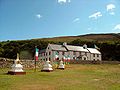
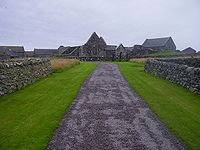
Culdee
Céli Dé or Culdees were originally members of ascetic Christian monastic and eremitical communities of Ireland, Scotland and England in the Middle Ages. The term is used of St. John the Apostle, of a missioner from abroad recorded in the Annals of the Four Masters at the year 806, and of Óengus...
/church connection, and/or are dominated by a church. The more notable include:
- Davaar IslandDavaar IslandDavaar Island or Island Davaar is located at the mouth of Campbeltown Loch off the east coast of Kintyre, in Argyll and Bute, Scotland. It is a tidal island, linked to the mainland by a natural shingle causeway called the Dhorlin near Campbeltown at low tide...
- EgilsayEgilsayEgilsay is one of the Orkney Islands in Scotland, lying east of Rousay. The island is largely farmland and is known for its corncrakes.-St. Magnus Church:...
- EynhallowEynhallowEynhallow is a small, presently uninhabited island, part of the Orkney Islands, off the north coast of Scotland.-Geography:Eynhallow lies in Eynhallow Sound between Mainland, Orkney and Rousay. It is in area....
- Holy IsleHoly Isle, Firth of ClydeThe Holy Isle, Firth of Clyde is one of a number of islands in the United Kingdom which go under the name "Holy Island". It is located in the Firth of Clyde off the west coast of central Scotland, inside Lamlash Bay on the larger island of Arran.- Details :The island is around long and around ...
- InchcolmInchcolmInchcolm is an island in the Firth of Forth in Scotland. Repeatedly attacked by English raiders during the Wars of Scottish Independence, it was fortified during both World Wars to defend nearby Edinburgh...
- Inch KennethInch KennethInch Kenneth is a small grassy island in the parish of Kilfinichen and Kilvickeon, Argyllshire. The island is situated at the entrance of Loch Na Keal, off the west coast of the Isle of Mull, Scotland, to the south-southeast of Ulva...
- InchmahomeInchmahomeInchmahome, an anglicisation of Innis Mo Cholmaig , is the largest of three islands in the Lake of Menteith, in Stirlingshire.- History :...
(F) - IonaIonaIona is a small island in the Inner Hebrides off the western coast of Scotland. It was a centre of Irish monasticism for four centuries and is today renowned for its tranquility and natural beauty. It is a popular tourist destination and a place for retreats...
- Isle MareeIsle MareeIsle Maree is an island in Loch Maree, Scotland.It has the remains of a chapel, graveyard, holy well, and holy tree on it, believed to be the 8th century hermitage of Saint Maol Rubha , who founded the monastery of Applecross in 672. The same island also contains ancient stands of oak and holly...
- North RonaNorth RonaRona is a remote Scottish island in the North Atlantic. Rona is often referred to as North Rona in order to distinguish it from South Rona . It has an area of and a maximum height of...
- OronsayOronsay, Inner HebridesOronsay , also sometimes spelt and pronounced Oransay by the local community, is a small tidal island south of Colonsay in the Scottish Inner Hebrides with an area of just over two square miles....
- Papa StronsayPapa StronsayPapa Stronsay is a small island in Orkney, Scotland, lying north east of Stronsay. It is in size, and at its highest point.According to folklore, some of the natives were descended from a female selkie. This was because they had horny skin on their feet and hands, and permanently smelt of...
(current Transalpine RedemptoristTransalpine RedemptoristThe Sons of the Most Holy Redeemer , formerly the Transalpine Redemptorists are a religious order based on Papa Stronsay in the Orkney Islands, Scotland. Their rule is based on that of St...
monastery. Islands called "Papa" or "Pabbay" tend to be former saints' islands) - St Ninian's IsleSt Ninian's IsleSt Ninian's Isle is a small island connected by the largest active tombolo in the UK to the south-western coast of the Mainland, Shetland, in Scotland. The tombolo, known locally as an ayre, from the Old Norse for 'gravel bank', is 500 metres long. Except at extremely high tides, the sand is above...
- St Serf's InchSt Serf's InchSt Serf's Inch or St Serf's Island is an island in Loch Leven, in south-eastern Perth and Kinross, Scotland. It was the home of a Culdee and then an Augustinian monastic community, St Serf's Inch Priory.-History:...
(F) - TireeTiree-History:Tiree is known for the 1st century BC Dùn Mòr broch, for the prehistoric carved Ringing Stone and for the birds of the Ceann a' Mhara headland....
("land of Iona")
Brother Isle
Brother Isle
Brother Isle is a small, uninhabited island in Shetland, Scotland. It lies between the islands of Yell and Shetland Mainland. It is in size.- Geography and geology :The island's rock is "undifferentiated moine gneiss and quartzite."- History :...
's name is not ecclesiastical in origin as is sometimes stated.
Islands named after people
This is a list of islands, which are known to be named after someone. In some cases such as North RonaldsayNorth Ronaldsay
North Ronaldsay is the northernmost of the Orkney Islands, Scotland and with an area of is the fourteenth largest.-Geography:North Ronaldsay lies around north of its nearest neighbour, Sanday at . The island is around long along its length and is defined by two large sandy bays; Linklet Bay on...
this status may not be obvious (it isn't named after a "Ronald", unlike South Ronaldsay
South Ronaldsay
South Ronaldsay is one of the Orkney Islands off the north coast of Scotland. It is linked to the Orkney Mainland by the Churchill Barriers, running via Burray, Glimps Holm and Lamb Holm.-Geography and geology:...
). This list omits names such as Hildasay
Hildasay
Hildasay , also known as Hildisay, is an uninhabited island off the west coast of the Shetland Mainland.-Geography and geology:...
, where the person in question is mythological, or Ailsa Craig
Ailsa Craig
Ailsa Craig is an island of 219.69 acres in the outer Firth of Clyde, Scotland where blue hone granite was quarried to make curling stones. "Ailsa" is pronounced "ale-sa", with the first syllable stressed...
, where the individual in question is not known, and also Colonsay
Colonsay
Colonsay is an island in the Scottish Inner Hebrides, located north of Islay and south of Mull and has an area of . It is the ancestral home of Clan Macfie and the Colonsay branch of Clan MacNeill. Aligned on a south-west to north-east axis, it measures in length and reaches at its widest...
& Egilsay
Egilsay
Egilsay is one of the Orkney Islands in Scotland, lying east of Rousay. The island is largely farmland and is known for its corncrakes.-St. Magnus Church:...
where the derivation is disputed.
- Eilean Chaluim ChilleEilean Chaluim ChilleEilean Chaluim Chille is an unpopulated island in the Outer Hebrides.It lies off the east coast of Lewis at the mouth of Loch Erisort. At low tide Eilean Chaluim Chille is connected by a causeway to the mainland of Lewis at Crobeag.-History:At the southern end of the island lie the ruins of St...
- Saint ColumbaSaint Columba-Saints:* Columba , Irish Christian saint who evangelized Scotland* Columba the Virgin, also known as Saint Columba of Cornwall* Columba of Sens* Columba of Spain* Columba of Terryglass* Sancta Columba -Schools:... - Island DavaarDavaar IslandDavaar Island or Island Davaar is located at the mouth of Campbeltown Loch off the east coast of Kintyre, in Argyll and Bute, Scotland. It is a tidal island, linked to the mainland by a natural shingle causeway called the Dhorlin near Campbeltown at low tide...
- Saint Barr - Eilean DonanEilean DonanEilean Donan is a small island in Loch Duich in the western Highlands of Scotland. It is connected to the mainland by a footbridge and lies about half a mile from the village of Dornie. Eilean Donan is named after Donnán of Eigg, a Celtic saint martyred in 617...
- Saint Donan - Flannan IslesFlannan IslesDesigned by David Alan Stevenson, the tower was constructed for the Northern Lighthouse Board between 1895 and 1899 and is located near the highest point on Eilean Mòr. Construction was undertaken by George Lawson of Rutherglen at a cost of £6,914 inclusive of the building of the landing places,...
- Saint FlannanSaint FlannanFlannán mac Toirrdelbaig was an Irish saint who lived in the 7th century and was the son of a king of Thomond. He entered Mo Lua's monastery at Killaloe and seems to have become abbot there. He is remembered as a great preacher.... - Frank Lockwood's Island (south of Lochbuie, MullLochbuie, MullLochbuie is a settlement on the island of Mull in Scotland about west of Craignure. The name is from the Scottish Gaelic Locha Buidhe, meaning "yellow loch".-Geography:...
) - InchcolmInchcolmInchcolm is an island in the Firth of Forth in Scotland. Repeatedly attacked by English raiders during the Wars of Scottish Independence, it was fortified during both World Wars to defend nearby Edinburgh...
- Saint ColumbaSaint Columba-Saints:* Columba , Irish Christian saint who evangelized Scotland* Columba the Virgin, also known as Saint Columba of Cornwall* Columba of Sens* Columba of Spain* Columba of Terryglass* Sancta Columba -Schools:... - Inch KennethInch KennethInch Kenneth is a small grassy island in the parish of Kilfinichen and Kilvickeon, Argyllshire. The island is situated at the entrance of Loch Na Keal, off the west coast of the Isle of Mull, Scotland, to the south-southeast of Ulva...
- Saint Kenneth - InchmarnockInchmarnockInchmarnock is an island at the northern end of the Sound of Bute on the west coast of Scotland.-Geography:Inchmarnock lies to the west of the Isle of Bute at the northern end of the Sound of Bute. It is around long and rises to a height of . The island consists mainly of a single ridge running...
- Saint Mearnag - InchmahomeInchmahomeInchmahome, an anglicisation of Innis Mo Cholmaig , is the largest of three islands in the Lake of Menteith, in Stirlingshire.- History :...
(F) - Saint Colmag - InchmurrinInchmurrinInchmurrin is an island in Loch Lomond in Scotland. It is the largest fresh water island in the British Isles.- Geography and geology :...
(F) - Saint Meadhran/Mirin - Innis Chonan (F) - Saint Conan
- Isle MareeIsle MareeIsle Maree is an island in Loch Maree, Scotland.It has the remains of a chapel, graveyard, holy well, and holy tree on it, believed to be the 8th century hermitage of Saint Maol Rubha , who founded the monastery of Applecross in 672. The same island also contains ancient stands of oak and holly...
(F) - Maelrubha - Isle MartinIsle MartinIsle Martin is an uninhabited island in Loch Broom, on the west coast of Scotland. It is the closest of the Summer Isles to Ullapool and has been the site of a monastery, a herring curing station and a flour mill. Now recognised as a bird sanctuary it is owned and managed by a community...
- Saint MartinMartin of ToursMartin of Tours was a Bishop of Tours whose shrine became a famous stopping-point for pilgrims on the road to Santiago de Compostela. Around his name much legendary material accrued, and he has become one of the most familiar and recognizable Christian saints... - North RonaNorth RonaRona is a remote Scottish island in the North Atlantic. Rona is often referred to as North Rona in order to distinguish it from South Rona . It has an area of and a maximum height of...
- Saint Ronan - St Serf's InchSt Serf's InchSt Serf's Inch or St Serf's Island is an island in Loch Leven, in south-eastern Perth and Kinross, Scotland. It was the home of a Culdee and then an Augustinian monastic community, St Serf's Inch Priory.-History:...
(F) - Saint SerfSaint SerfSaint Serf or Serbán is a saint of Scotland. Serf was venerated in western Fife. He is also called the apostle of Orkney, with less historical plausibility. Saint Serf is also somehow connected with Saint Mungo's Church near Simonburn, Northumberland... - Eilean SùbhainnEilean SùbhainnEilean Sùbhainn is the largest of several small islands in Loch Maree, Wester Ross, Scotland. It is the second largest freshwater island in Scotland after Inchmurrin....
(F) - ?Saint Swithin - Sweyn HolmSweyn HolmNote: There is also a "Sweyn Holm" off St Ninian's Isle, ShetlandSweyn Holm is a small island in the Orkney Islands, next to Gairsay.It is thought to be named for Sweyn Asleifsson , who was connected with Gairsay or possibly a corruption of "servant's island" in Norse.-References:...
Sweyn AsleifssonSweyn AsleifssonSweyn Asleifsson was twelfth century Viking who appeared in the Orkneyinga Saga.-Early career:Sweyn was born in Caithness in the early twelfth century, to Olaf Hrolfsson and his wife Åsleik. According to the Orkneyinga Saga, he came to prominence when he murdered Earl Paul of Orkney's cup-bearer c... - TaransayTaransayTaransay is an island in the Outer Hebrides of Scotland. It is famous for being the host of the British television series Castaway 2000. Uninhabited since 1974, except for holidaymakers, Taransay is the largest island in Scotland that lacks a permanent population...
- Saint Taran
Iqbal Singh, the owner of Vacsay
Vacsay
Vacsay is one of the Outer Hebrides. It is off the west coast of Lewis in West Loch Roag. It is in size, and 34 metres at its highest point.-History:...
, has also expressed wishes to rename it after Robert Burns
Robert Burns
Robert Burns was a Scottish poet and a lyricist. He is widely regarded as the national poet of Scotland, and is celebrated worldwide...
.
Places called "island" etc. that are not islands
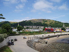
Lewis and Harris are separated by a range of hills but form one island, and are sometimes referred to as "Lewis and Harris
Lewis and Harris
Lewis and Harris in the Outer Hebrides make up the largest island in Scotland. This is the largest single island of the British Isles after Great Britain and Ireland.-Geography:...
". Isle of Whithorn and the Black Isle are peninsulas, and Isleornsay is a village which looks out onto the island of Ornsay
Ornsay
Ornsay is a small tidal island to the east of the Sleat peninsula on the Isle of Skye in the Inner Hebrides of Scotland.-Description:Widely acknowledged as one of the most beautiful tidal islands in Western Scotland, the island provides good shelter to a natural harbour which is overlooked by the...
. There is no commonly accepted derivation for "Burntisland" which had numerous other forms in the past, such as "Brintilun" and "Ye Brint Eland".
Gluss Isle at the western entrance to Sullom Voe
Sullom Voe
Sullom Voe is an inlet between North Mainland and Northmavine on Shetland in Scotland. It is a location of the Sullom Voe oil terminal. The word Voe is from the Old Norse vagr and denotes a small bay or narrow creek...
is one of the many promontories in Orkney and Shetland connected to a larger body of land by an ayre
Ayre (landform)
An ayre is a name often applied to shingle beaches in Orkney and Shetland. The term is derived from the Old Norse wordfor a shingle beach - "eyrr" - and may be applied to ordinary beaches, to cliff-foot beaches to spits, bars and tombolos, but only if formed of shingle. It is sometimes wrongly...
.
Other elements
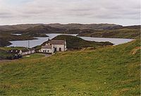
Inchcolm
Inchcolm is an island in the Firth of Forth in Scotland. Repeatedly attacked by English raiders during the Wars of Scottish Independence, it was fortified during both World Wars to defend nearby Edinburgh...
), but is also used for terra firma surrounded by marsh e.g. Markinch
Markinch
Markinch is a small town situated in the heart of Fife, in the eastern central lowlands of Scotland. According to an estimate taken in 2008, the town...
, Insch
Insch
Insch is a village in Garioch, Aberdeenshire, Scotland. It is located approximately from the city of Aberdeen.-Etymology:The name of the village may have come from the Scottish Gaelic innis, meaning an island, or, as in this context, a piece of terra firma in a marsh...
.
Eilean is Gaelic
Scottish Gaelic language
Scottish Gaelic is a Celtic language native to Scotland. A member of the Goidelic branch of the Celtic languages, Scottish Gaelic, like Modern Irish and Manx, developed out of Middle Irish, and thus descends ultimately from Primitive Irish....
for "island". However, Inistrynich, Eilean na Maodail, Eilean Dubh and Liever Island are all promontories
Promontory
Promontory may refer to:*Promontory, a prominent mass of land which overlooks lower lying land or a body of water*Promontory, Utah, the location where the United States first Transcontinental Railroad was completed...
on Loch Awe
Loch Awe
Loch Awe is a large body of water in Argyll and Bute, Scotland. It has also given its name to a village on its banks, variously known as Loch Awe, or Lochawe. There are islands within the loch such as Innis Chonnell and Inishail.- The loch :It is the third largest freshwater loch in Scotland with...
as opposed to islands, despite their names. Likewise Eilean Aoidhe on Loch Fyne
Loch Fyne
Loch Fyne is a sea loch on the west coast of Argyll and Bute, Scotland. It extends inland from the Sound of Bute, making it the longest of the sea lochs...
. The Black Isle is also An t-Eilean Dubh in Gaelic, while Eilean Glas
Eilean Glas, Scalpay
This particular Eilean Glas is actually a peninsula of Scalpay in the Outer Hebrides, Scotland. Eilean Glas is home to a historic lighthouse. Eilean Glas means Grey/Green Island in Gaelic.-Geography:Eilean Glas lies on the west coast of Scalpay at...
is part of Scalpay.
"-holm" is also common as a suffix in various landlocked placenames, especially in the far south of mainland Scotland e.g. Langholm
Langholm
Langholm , also known colloquially as the "Muckle Toon", is a burgh in Dumfries and Galloway, Scotland, on the River Esk and the A7 road.- History:...
, Kirk Yetholm
Kirk Yetholm
Kirk Yetholm is a village in the Scottish Borders region of Scotland, south east of Kelso and less than west of the border. The first mention is of its church in the 13th century. Its sister town is Town Yetholm which lies half a mile across the Bowmont Water...
, Holmhead (by Cumnock
Cumnock
Cumnock is a town in East Ayrshire, Scotland. The town sits at the confluence of the Glaisnock Water and the Lugar Water...
), Holmhill (next to Thornhill
Thornhill, Dumfries and Galloway
Thornhill is a town in the Mid Nithsdale area of Dumfries and Galloway, Scotland, south of Sanquhar and north of Dumfries.A monument to the explorer Joseph Thomson , who lived in neighbouring Penpont and Gatelawbridge, can be found close to the school...
, Nithsdale
Nithsdale
Nithsdale , also known by its anglicised gaelic name Strathnith or Stranit, is the valley of the River Nith in Scotland, and the name of the region...
). Some of these were river islands in their time, or dry land surrounded by marsh. "Holm" can be found in an element in Holmsgarth, now a suburb of Lerwick
Lerwick
Lerwick is the capital and main port of the Shetland Islands, Scotland, located more than 100 miles off the north coast of mainland Scotland on the east coast of the Shetland Mainland...
and the Parish of Holm
Holm, Mainland Orkney
Holm, pronounced "Ham", is a parish on Mainland, Orkney. It is not to be confused with the many Orkney Islands with "holm" in their name.An adjacent Sound, running between Mainland, and Burray, is also named after Holm. It has since been blocked up by the Churchill Barriers...
on Mainland Shetland and Mainland Orkney respectively. Neither of these is an island in its own right.
Islands named after mainland areas
Likewise, occasionally an island may be named after a location on the nearby mainland, or a major neighbouring island - or vice versa. Examples of this include: VementryVementry
Vementry is an uninhabited island in Shetland, Scotland, on the north side of the West Mainland, lying south of Muckle Roe....
, which was originally the name of an island, but whose name has been transferred to a nearby farm on Mainland Shetland; Oldany Island
Oldany Island
Oldany Island is an uninhabited island in Assynt, Sutherland, north-west Scotland.The name is Norse in origin.-Geography:...
, whose name has been transferred to Oldany; Cramond Island
Cramond Island
Cramond Island is one of several islands that lie in the Firth of Forth in eastern Scotland, near Edinburgh. As its name implies, it lies off Cramond. It is long and covers , and is currently part of the Dalmeny Estate.Strictly speaking it is not a true island at all, but a tidal island being...
which is named after neighbouring Cramond
Cramond
Cramond is a seaside village now part of suburban Edinburgh, Scotland, located in the north-west corner of the city at the mouth of the River Almond where it enters the Firth of Forth....
(a district of Edinburgh
Edinburgh
Edinburgh is the capital city of Scotland, the second largest city in Scotland, and the eighth most populous in the United Kingdom. The City of Edinburgh Council governs one of Scotland's 32 local government council areas. The council area includes urban Edinburgh and a rural area...
); and Eilean Mhealasta
Eilean Mhealasta
Eilean Mhealasta is an uninhabited island off the west coast of Lewis in the Outer Hebrides of Scotland. It takes its name from Mealista, a nearby township on Lewis.-History:...
in the Outer Hebrides, which is named after Mealista
Mealista
Mealista or Mealasta is a township in the west of the Isle of Lewis. It is currently largely uninhabited due to the Highland Clearances, which occurred there in 1838....
on Lewis.
Crannógs
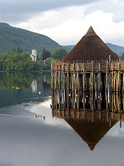
Crannog
A crannog is typically a partially or entirely artificial island, usually built in lakes, rivers and estuarine waters of Scotland and Ireland. Crannogs were used as dwellings over five millennia from the European Neolithic Period, to as late as the 17th/early 18th century although in Scotland,...
s are prehistoric
Prehistory
Prehistory is the span of time before recorded history. Prehistory can refer to the period of human existence before the availability of those written records with which recorded history begins. More broadly, it refers to all the time preceding human existence and the invention of writing...
artificial islands created in lochs. There are several hundred sites in Scotland. Today, crannógs typically appear as small, circular islands, between 10–30 metres (30–90 feet) in diameter. Scottish examples include:
- BreachachaBreachacha crannogThe Breachacha crannog is a crannog located near Loch Breachacha, on the Inner Hebridean island of Coll. The crannog is recognised in the United Kingdom as a Scheduled monument. A scheduled monument is a 'nationally important' archaeological site or historic building, given legal protection against...
on Coll - Cherry IslandCherry Island (Loch Ness)Cherry Island is the only island in Loch Ness, Highland, Scotland, and is an example of a crannog. The island is about from the shore near the southern end of the loch. The island was originally by across, but is now smaller as the level of the loch was raised when it became part of the...
in Loch Ness - Dùn AnlaimhDùn AnlaimhDùn Anlaimh, also known as Dùn Amhlaidh, and Eilean nan Cinneachan, is a crannog , located within Loch nan Cinneachan on the Inner Hebridean island of Coll. Upon the crannog there are the remains of walls and several buildings...
on Coll - Eilean DòmhnuillEilean DomhnuillArmit identifies the islet of Eilean Dòmhnuill , Loch Olabhat on North Uist, Scotland as what may be the earliest crannog. Unstan ware pottery found there suggests a Neolithic period date of 3200-2800 BC...
on North Uist - Keppinch (or The Kitchen) in Loch Lomond
See also
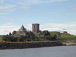
- Scottish island namesScottish island namesThe modern names of Scottish islands stem from two main influences. There are a large number of names that derive from the Scottish Gaelic language in the Hebrides and Firth of Clyde. In the Northern Isles most place names have a Norse origin...
- Geography of ScotlandGeography of ScotlandThe geography of Scotland is highly varied, from rural lowlands to barren uplands, and from large cities to uninhabited islands. Located in north-west Europe, Scotland comprises the northern one third of the island of Great Britain...
- List of Orkney islands
- List of Outer Hebrides
- List of Shetland islands
- List of Marilyns on Scottish islands
- List of lochs on Scottish islands
- British IslesBritish IslesThe British Isles are a group of islands off the northwest coast of continental Europe that include the islands of Great Britain and Ireland and over six thousand smaller isles. There are two sovereign states located on the islands: the United Kingdom of Great Britain and Northern Ireland and...
- List of the British Isles by area
- Infobox Scottish island
- Template:Hebrides
- Template:Shetland
- Template:Islands of the Forth
:Category:Scottish Island set index articles