
Ceann Iar
Encyclopedia
Disambiguation: "Ceann Iar" is a common Scottish placename meaning Western Headland
Ceann Iar (Gaelic "Western Headland") is one of the Monach Isles/Heisgeir, to the west of North Uist
in the Outer Hebrides
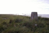
. It is a slender island, approximately a mile, or two kilometres long.
 Ceann Iar is the second largest of the Monach Islands. It is connected at low tide to Ceann Ear
via Sibhinis
. It is said that it was at one time possible to walk all the way to Baleshare
, and on to North Uist
, five miles away at low tide. In the 16th century, a large tidal wave was said to have washed this away. Despite Ceann Iar's name, Shillay
is in fact the westernmost of the group.
Like the other islands of the group, it is a low lying, sandy island, subject to intense coastal erosion. Not unlike the Isles of Scilly
it is possible that Ceann Iar, Sibhinis and Ceann Ear formed a single body of land within historic times, and that their land area has greatly decreased due to overgrazing, and wind erosion as well.
On the east side is Baile Beag (wee town), the settlement of the island, which is in turn on the slopes of Cnoc Bhàrr (top hill), which at 19 metres in height is a mere metre higher than neighbouring Ceann Ear
's hillocks. In the north, there is also Cnoc Mòr (big hill), which is the other "height" on the island. The west is formed by Rubha Shulabhaig (a headland), and the north east by Hearnish. Just to the north is the island of S(t)ròmaigh (from Old Norse meaning "storm island")
. The ship hit a mine in 1917, during WWI, off Northern Ireland
, and his body had drifted all the way to here. Strangely, this accords with the old Hebridean tradition that the sea carries the drowned home - the Monachs are Clan MacNeil
territory.
The island had been settled intermittently for over a thousand years, although the main settlement was on Ceann Ear. It was resettled in the wake of the Highland Clearances
, but finally abandoned in 1942.
Ceann Iar (Gaelic "Western Headland") is one of the Monach Isles/Heisgeir, to the west of North Uist
North Uist
North Uist is an island and community in the Outer Hebrides of Scotland.-Geography:North Uist is the tenth largest Scottish island and the thirteenth largest island surrounding Great Britain. It has an area of , slightly smaller than South Uist. North Uist is connected by causeways to Benbecula...
in the Outer Hebrides
Outer Hebrides
The Outer Hebrides also known as the Western Isles and the Long Island, is an island chain off the west coast of Scotland. The islands are geographically contiguous with Comhairle nan Eilean Siar, one of the 32 unitary council areas of Scotland...
. It is a slender island, approximately a mile, or two kilometres long.
Geography
Ceann Ear
Disambiguation: "Ceann Ear" is a common Scottish placename meaning Eastern HeadlandCeann Ear is the largest island in the Monach or Heisgeir group off North Uist in north west Scotland. It is in size and connected by sandbanks to Ceann Iar via Sibhinis at low tide. It is said that it was at one...
via Sibhinis
Sibhinis
Sibhinis, Siobhanais or Shivinish. is one of the Monach Islands, lying between Ceann Iar and Ceann Ear. It is tidal, and connected at low tide to Ceann Iar by Fadhail Shibhinis, and to Ceann Ear by Faodhail Chinn Ear. It is 16m at its highest point...
. It is said that it was at one time possible to walk all the way to Baleshare
Baleshare
Baleshare is a flat tidal island in the Outer Hebrides of Scotland.Baleshare lies to the south-west of North Uist. Its economics and community were boosted by the building of a causeway in 1962. The 350m causeway was built by William Tawse Ltd. The island is extremely flat by Hebridean standards,...
, and on to North Uist
North Uist
North Uist is an island and community in the Outer Hebrides of Scotland.-Geography:North Uist is the tenth largest Scottish island and the thirteenth largest island surrounding Great Britain. It has an area of , slightly smaller than South Uist. North Uist is connected by causeways to Benbecula...
, five miles away at low tide. In the 16th century, a large tidal wave was said to have washed this away. Despite Ceann Iar's name, Shillay
Shillay, Monach Islands
Shillay is the western-most of the Monach Islands , off North Uist in the Outer Hebrides.-Geology and geography:...
is in fact the westernmost of the group.
Like the other islands of the group, it is a low lying, sandy island, subject to intense coastal erosion. Not unlike the Isles of Scilly
Isles of Scilly
The Isles of Scilly form an archipelago off the southwestern tip of the Cornish peninsula of Great Britain. The islands have had a unitary authority council since 1890, and are separate from the Cornwall unitary authority, but some services are combined with Cornwall and the islands are still part...
it is possible that Ceann Iar, Sibhinis and Ceann Ear formed a single body of land within historic times, and that their land area has greatly decreased due to overgrazing, and wind erosion as well.
On the east side is Baile Beag (wee town), the settlement of the island, which is in turn on the slopes of Cnoc Bhàrr (top hill), which at 19 metres in height is a mere metre higher than neighbouring Ceann Ear
Ceann Ear
Disambiguation: "Ceann Ear" is a common Scottish placename meaning Eastern HeadlandCeann Ear is the largest island in the Monach or Heisgeir group off North Uist in north west Scotland. It is in size and connected by sandbanks to Ceann Iar via Sibhinis at low tide. It is said that it was at one...
's hillocks. In the north, there is also Cnoc Mòr (big hill), which is the other "height" on the island. The west is formed by Rubha Shulabhaig (a headland), and the north east by Hearnish. Just to the north is the island of S(t)ròmaigh (from Old Norse meaning "storm island")
History
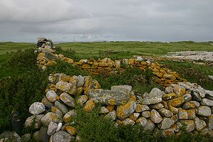
A cairn on Ceann Iar marks the grave of Lieutenant RNR MacNeill of the HMA LaurenticSS Laurentic (1908)
SS Laurentic was a British ocean liner of the White Star Line.The Dominion Line steamship company operated liners on the Liverpool-Canada route in the late 19th and early 20th centuries. Their ships had become outdated, so in 1907 two new liners were ordered from Harland and Wolff, the SS Alberta...
. The ship hit a mine in 1917, during WWI, off Northern Ireland
Northern Ireland
Northern Ireland is one of the four countries of the United Kingdom. Situated in the north-east of the island of Ireland, it shares a border with the Republic of Ireland to the south and west...
, and his body had drifted all the way to here. Strangely, this accords with the old Hebridean tradition that the sea carries the drowned home - the Monachs are Clan MacNeil
Clan MacNeil
Clan MacNeil, also known in Scotland as Clan Niall, is a highland Scottish clan, particularly associated with the Outer Hebridean island of Barra. The early history of Clan MacNeil is obscure, however despite this the clan claims to descend from the legendary Niall of the nine hostages...
territory.
The island had been settled intermittently for over a thousand years, although the main settlement was on Ceann Ear. It was resettled in the wake of the Highland Clearances
Highland Clearances
The Highland Clearances were forced displacements of the population of the Scottish Highlands during the 18th and 19th centuries. They led to mass emigration to the sea coast, the Scottish Lowlands, and the North American colonies...
, but finally abandoned in 1942.