
Housay
Encyclopedia
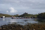
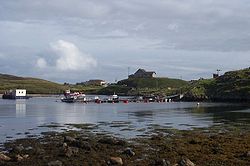
Housay, also known as West Isle, is one of the three islands that form the Out Skerries island group, the most easterly part of the Shetland Isles. It has a population of approximately 45 people.
 Housay has the most complex geology of the Out Skerries, with granite
in Mio Ness in the far south west, limestone
on the south coast, and large concentrations of gneiss
and schist
.
The island of Housay consists of several thin headlands, with the biggest pointing to the south west, and over 1 miles (1.6 km) long. To the north, another headland extends, and then turns towards the south west, running parallel to the biggest one, and separated by West Voe.
The island is surrounded by a number of stacks including the Hevda Stacks in the north and the Stack a Mooth & Stack a Pillar in the south. There are also some sea caves in the south, and Da Steig, which connects the island to Mio Ness is a collapsed one.
It is separated from Bruray
by North Mouth and South Mouth.
The island occasionally suffers from water shortages. There is little peat
on the Out Skerries, so the residents have been granted rights to cut in on Whalsay
.
The island's population peaked in 1891 with nearly ninety people, now it is approximately half that. 45 people were recorded in 1991, although the population increased to 50 by 2001.
At the autumn 2010, the islands of Housay and Bruray
(600.00 acres) were on sale for £250,000. "The main islands are held under crofting tenure. the Crofting community have been offered the opportunity to register their interest inacquiring the property but have formally declined from doing so."
The Skerries Bridge was built in 1957 to provide a fixed link from Bruray to the neighbouring and larger island of Housay.
Geography and geology
Granite
Granite is a common and widely occurring type of intrusive, felsic, igneous rock. Granite usually has a medium- to coarse-grained texture. Occasionally some individual crystals are larger than the groundmass, in which case the texture is known as porphyritic. A granitic rock with a porphyritic...
in Mio Ness in the far south west, limestone
Limestone
Limestone is a sedimentary rock composed largely of the minerals calcite and aragonite, which are different crystal forms of calcium carbonate . Many limestones are composed from skeletal fragments of marine organisms such as coral or foraminifera....
on the south coast, and large concentrations of gneiss
Gneiss
Gneiss is a common and widely distributed type of rock formed by high-grade regional metamorphic processes from pre-existing formations that were originally either igneous or sedimentary rocks.-Etymology:...
and schist
Schist
The schists constitute a group of medium-grade metamorphic rocks, chiefly notable for the preponderance of lamellar minerals such as micas, chlorite, talc, hornblende, graphite, and others. Quartz often occurs in drawn-out grains to such an extent that a particular form called quartz schist is...
.
The island of Housay consists of several thin headlands, with the biggest pointing to the south west, and over 1 miles (1.6 km) long. To the north, another headland extends, and then turns towards the south west, running parallel to the biggest one, and separated by West Voe.
The island is surrounded by a number of stacks including the Hevda Stacks in the north and the Stack a Mooth & Stack a Pillar in the south. There are also some sea caves in the south, and Da Steig, which connects the island to Mio Ness is a collapsed one.
It is separated from Bruray
Bruray
Bruray is one of the three Out Skerries islands of Shetland, and contains Scotland's most easterly settlement.It is separated from Housay by North Mouth and South Mouth.-Infrastructure:...
by North Mouth and South Mouth.
The island occasionally suffers from water shortages. There is little peat
Peat
Peat is an accumulation of partially decayed vegetation matter or histosol. Peat forms in wetland bogs, moors, muskegs, pocosins, mires, and peat swamp forests. Peat is harvested as an important source of fuel in certain parts of the world...
on the Out Skerries, so the residents have been granted rights to cut in on Whalsay
Whalsay
-Geography:Whalsay, also known as "The Bonnie Isle", is a peat-covered island in the Shetland Islands. It is situated east of the Shetland Mainland and has an area of . The main settlement is Symbister, where the fishing fleet is based. The fleet is composed of both pelagic and demersal vessels...
.
History
The large number of Norse placenames suggest that it has been inhabited since at least then, if not earlier.The island's population peaked in 1891 with nearly ninety people, now it is approximately half that. 45 people were recorded in 1991, although the population increased to 50 by 2001.
At the autumn 2010, the islands of Housay and Bruray
Bruray
Bruray is one of the three Out Skerries islands of Shetland, and contains Scotland's most easterly settlement.It is separated from Housay by North Mouth and South Mouth.-Infrastructure:...
(600.00 acres) were on sale for £250,000. "The main islands are held under crofting tenure. the Crofting community have been offered the opportunity to register their interest inacquiring the property but have formally declined from doing so."
Infrastructure
The post office, one of Skerries two shops, the church and the public hall are located here.The Skerries Bridge was built in 1957 to provide a fixed link from Bruray to the neighbouring and larger island of Housay.