
Rockall
Encyclopedia
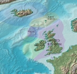
Rockall is an extremely small, uninhabited, remote rocky islet
in the North Atlantic Ocean
. It gives its name to one of the sea areas named in the shipping forecast
provided by the British Meteorological Office
.
Historically the islet has been referred to in Irish folklore, and since the late sixteenth century it has been noted in written records, although it is likely that some northern Atlantic fishing crews knew of the rock before these historical accounts were made. In the twentieth century the location of the islet became a major concern due to oil and fishing rights, spurring continued debate amongst several European nations.
Rockall has also been a point of interest for adventurers and amateur radio
operators who variously in the past have landed on or occupied the islet for up to several months, although fewer than twenty individuals have ever been confirmed to have landed on Rockall.
In 1956 the British scientist James Fisher
referred to the island as "the most isolated small rock in the oceans of the world." The neighbouring Hasselwood Rock
and several other pinnacles of the surrounding Helen's Reef
are however smaller, at half or less the size of Rockall and equally remote. Yet these formations are, while being noted in the Island of Rockall Act 1972
, technically not considered islands or points on land per se, as they are often submerged completely, only revealed momentarily under certain types of swell and visible by ocean surface wave
s.
The ownership of Rockall is disputed, as are the exploration and fishing rights on the surrounding Rockall Bank and Trough, and the Rockall Plateau. The islet is claimed by Denmark
(for the Faroe Islands
), Iceland
, Ireland
and the United Kingdom
. All four governments have made submissions to the commission set up under the United Nations Convention on the Law of the Sea
. The issue was included in the provisional agenda of the meeting of the commission to be held in New York from 7 March to 21 April 2011 and recommendations pursuant to Article 76 of the Convention were made.
The United Kingdom, for administrative purposes, initially treated Rockall as part of Inverness-shire
, under the terms of the Island of Rockall Act 1972. Subsequent UK Acts of Parliament have affirmed the islet's position as part of the Comhairle nan Eilean Siar
council area for local government functions.
 The origin of the name Rockall is uncertain but it has been suggested that it derives from the Gaelic
Sgeir Rocail, meaning skerry
(or sea rock) of roaring, (although rocail can also be translated as "tearing" or "ripping"). There may also be an etymological link with the Old Norse 'hrukka'.
The first literary reference to the island, where it is called Rokol, is found in Martin Martin
's A Description of the Western isles of Scotland published in 1703
. In the book the author gives an account of a voyage to the archipelago
of St. Kilda
and its proximity to Rockall: "... and from it lies Rokol, a small rock sixty leagues to the westward of St. Kilda; the inhabitants of this place call it 'Rokabarra
'."
Dutch mapmakers P. Plancius and C. Claesz show an island 'Rookol' northwest of Ireland
in the their Map of New France and the Northern Atlantic Ocean (Amsterdam, c. 1594). The name 'Rocabarraigh
' is also used in Scottish Gaelic folklore
for a mythical rock which is supposed to appear three times, the last being at the end of the world: "Nuair a thig Rocabarra ris, is dual gun tèid an Saoghal a sgrios" (When Rocabarra returns, the world will likely come to be destroyed).
It has most recently been suggested that the name is really Old Norse, and derives from the word *rok (as in Icelandic rok), meaning 'foaming sea', and kollR, meaning 'bald head', a word which appears in other local names in Scandinavian-speaking areas. The Gaelic name would then be derivable from the Norse form.
 The islet of Rockall makes up the eroded core of an extinct volcano (a volcanic plug
), and is one of the few pinnacles of the surrounding Helen's Reef
. It is located 301.4 kilometres (187.3 mi), or 162.7 nmi
, west of the islands of St Kilda, Scotland
, and 430 kilometres (267.2 mi) north-west of County Donegal
in Ireland. The surrounding elevated seabed is called the Rockall Bank, lying directly south from an area known as the Rockall Plateau. It is separated from the Western Isles by the Rockall Trough, itself located within the Rockall Basin
. (Also known as the "Hatton Rockall Basin".) The Anton Dohrn Seamount
is a submarine elevation on Rockall Trough about halfway between Rockall and the Outer Hebrides
.
Cold-water coral
mounds have been identified in the region, They are currently being researched. Rockall lies near the Darwin Mounds
, deep-water coral
mounds about 185 km (100 nmi or 115 mi) north-west of Cape Wrath
.
These corals are long-lived and slow-growing, a justification for designating Rockall and the Rockall as a Marine Protected Area.
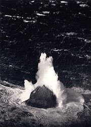
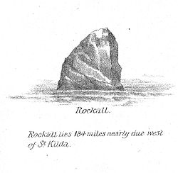
Rockall is about 25.3 metres (83 ft) wide and 31 metres (101.7 ft) long at its base and rises sheer to a height of approximately 21.4 metres (70.2 ft). It is regularly washed over by large storm waves, particularly in winter
. There is a small ledge of 3.5 by 1.3 metres (11 by 4 ft), known as Hall's Ledge, 4 metres (13.1 ft) from the summit on the rock's western face. It is the only named geographical location on the rock, other than Rockall as a whole.
Rockall is mapped by the Ordnance Survey
, but as it is officially outside the OSGB grid
it is usually shown as an inset without gridlines on a mainland sheet. The nearest point on land from Rockall is 301.4 kilometres (187.3 mi), or 162.7 nmi, east at the uninhabited Scottish island of Soay
in the St. Kilda archipelago. The nearest inhabited area lies 303.3 kilometres (188.5 mi), or 163.8 nmi, east at Hirta
, the largest island in the St. Kilda group, which is populated intermittently at a single military base. The nearest permanently inhabited settlement is 367 kilometres (228 mi), or 198.1 nmi, west of the headland of Aird an Runair
, near the crofting township of Hogha Gearraidh on the island of North Uist
at . North Uist is part of the Na h-Eileanan Siar
council area of Scotland.
s and other marine molluscs. Small numbers of seabirds, mainly fulmar
s, northern gannet
s, black-legged kittiwakes
, and common guillemot
s, use the rock for resting in summer, and gannets and guillemots occasionally breed successfully if the summer is calm with no storm waves washing over the rock. In total there have been just over 20 species of seabird and 6 other animal species observed (including the aforementioned molluscs) on or near the islet.
 The exact position of Rockall and the size and shape of the Rockall Bank was first charted in 1831 by Captain A.T.E. Vidal
, a Royal Navy
surveyor. The first scientific expedition to Rockall was led by Miller Christie in 1896 when the Royal Irish Academy
sponsored a study of the flora and fauna. They chartered the Granuaile.
The RV Celtic Explorer surveyed the Rockall Bank and North West of Donegal
in 2003. The ILV Granuaile was chartered by the Geological Survey of Ireland
(GSI), on behalf of the Department of Communications, Marine and Natural Resources (DCMNR), to conduct a seismic survey at the Rockall and Hatton Banks in July 2004. The seismic survey was part of the National Seabed Survey which has been ongoing for four years.
Rockall is made of a type of peralkaline
granite
that is relatively rich in sodium
and potassium
. Within this granite are darker bands richer in the alkali
pyroxene
mineral
aegirine
and the alkali amphibole
mineral riebeckite
. The dark bands are a type of granite that geologists have named "rockallite", although use of this term is now discouraged. In 1975, a new mineral
was discovered on Rockall. The mineral is called bazirite, (chemical composition BaZrSi3O9), named after the elements barium
and zirconium
. Rockall forms part of the deeply eroded Rockall Igneous Centre that was formed as part of the North Atlantic Igneous Province
, approximately 55 million years ago, when the ancient continent of Laurasia
was split apart by plate tectonics
. Greenland and Europe separated and the north-east Atlantic Ocean was formed between them.
and Helen's Reef (the latter was not named until 1830).
There have also been reports in national newspapers in both Ireland and the United Kingdom that at least two unexploded bombs from World War II lie within a 250-metre radius of Rockall. At present, no attempts have been made to remove them.
.”
The convention was ratified by all four states in dispute over the Rockall Plateau – Iceland on 26 January 1985, Ireland on 21 January 1996, the United Kingdom on 25 July 1997 and Denmark on 16 November 2004.
The twenty-fourth session of the United Nations Commission on the Limits of the Continental Shelf (CLCS) was held in New York from 10 August to 11 September 2009. Iceland, Ireland, and the United Kingdom have made submissions. Denmark will make a submission before 2014.
On 7 November 1988 the United Kingdom and Ireland agreed a delineation which ignores Rockall's existence and have granted exploration rights. This bilateral agreement is disputed by Iceland and by Denmark.
(EEZ) claimed by the United Kingdom. In 1997, the UK ratified the United Nations Convention on the Law of the Sea and thus relinquished any claim to an extension of its EEZ beyond the islet. The remaining issue is the status of the continental shelf rights of surrounding ocean floor. These are the exclusive rights to exploit any resources on or under the ocean floor (oil
, natural gas
, etc.) and should not be confused with the EEZ, as continental shelf rights do not carry any privileges with regard to fisheries. Ownership of these rights in the Rockall area are disputed between the United Kingdom, Denmark (for the Faroe Islands), Ireland and Iceland.
 The nearest (seasonally) inhabited land to Rockall is Hirta
, and the nearest permanently inhabited land is North Uist, both of which are in the United Kingdom (see above). In 1997 the United Kingdom ratified the 1982 United Nations Convention on the Law of the Sea. In doing so it relinquished its right to claim an exclusive economic zone
(EEZ) of 200 nmi (370 km) extending onward from the rock, as the agreement states that "Rocks which cannot sustain human habitation or economic life of their own shall have no exclusive economic zone or continental shelf". However, as Rockall lies within 200 nmi (370 km) of both St. Kilda and North Uist, the island itself remains within the EEZ of the United Kingdom and, as such, under international law
the UK can claim "…the sovereignty of the coastal state in relation to the exploitation, conservation and management of natural and living resources fishery and mineral resources" of the rock itself and an area of territorial waters
extending for 12 nmi (22.2 km) around it. Furthermore, the United Kingdom and Ireland have signed an EEZ boundary agreement which includes Rockall in the United Kingdom area.
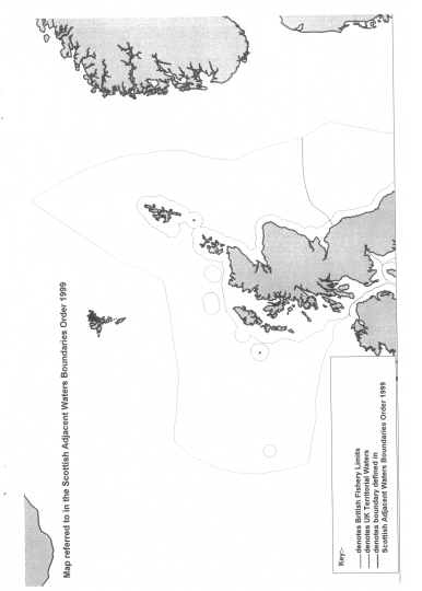
Rockall, and a large sea area around it, was declared as coming under the jurisdiction
of Scots law
under the Scottish Adjacent Waters Boundaries Order
(map) in 1999. This sea area is co-terminous with the UK's EEZ.
The date for the earliest recorded landing on the island is often given as 8 July 1810, when a Royal Navy
officer named Basil Hall
led a small landing party from the frigate
to the summit. However, research by James Fisher
of the 1955 landing (see below) in the log of the Endymion and elsewhere, indicates that the true date for this first landing was Sunday 8 September 1811.
The Endymion was taking depth measurements around Rockall when it drifted away in a haze. The expedition made a brief attempt to find the frigate in the haze, but soon gave up and returned to Rockall. After the haze became a fog, the lookout sent to the top of Rockall spotted the ship again, but it turned away from Rockall before the expedition in their boats reached it. Finally, just before sunset, the frigate was again spotted from the top of Rockall, and the expedition was able to get back on board. The crew of the Endymion reported that they had been searching for five or six hours, firing their cannon every ten minutes. Hall related this experience and other adventures in a book entitled Fragment of Voyages and Travels Including Anecdotes of a Naval Life.
The next landing was accomplished by a Mr Johns of , whilst the ship was on a mission, from June and August 1862, to make a survey of the sea bed prior to the laying of a transatlantic telegraph cable
. Johns managed to gain foothold on the island, but failed to reach the summit.
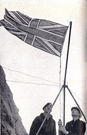
On 18 September 1955 at precisely 10.16 am, in what would be the final territorial expansion of the British Empire
, the island was officially annexed
by the British Crown when Lieutenant-Commander Desmond Scott RN
, Sergeant
Brian Peel RM
, Corporal
AA Fraser RM, and James Fisher
(a civilian naturalist
and former Royal Marine), were deposited on the island by a Royal Navy helicopter from (coincidentally named after the man who first charted the island). The team cemented in a brass plaque on Hall's Ledge and hoisted the Union Flag
to stake the UK's claim. The inscription on the plaque read:
In 2010, it was revealed that the plaque had gone missing. An Englishman, Andy Strangeway
, announced his intention to land on the island and affix a replacement plaque in June 2010. The Western Isles Council have approved planning permission for the plaque. The 2010 expedition was cancelled, but Strangeway still intends to replace the plaque. This he intends to do in 2011.
The formal annexation of Rockall was announced by the Admiralty
on 21 September 1955. The initial incentive for this had little to do with any territorial claim to rights of exploitation of the seas around the island. It was the test firing of the UK's first guided nuclear weapon
, the American
-made Corporal missile
. The missile was to be launched from South Uist and over the North Atlantic. The Ministry of Defence
was concerned that the unclaimed island would provide a unique opportunity for the Soviet Union
to spy on the test by placing surveillance equipment on the island; and so in April 1955 a request was sent to the Admiralty to seize the island, and declare UK sovereignty lest it become an outpost for foreign observers.
On 10 February 1972, the Island of Rockall Act
received Royal Assent
to make the island administratively part of the Isle of Harris (St. Kilda being administratively part of Harris), in what was then Inverness-shire
, fully incorporating it into the United Kingdom. A navigational beacon was later installed on the island and the UK declared that no ship would be allowed within a 50 miles (80.5 km) radius of the rock. In United Kingdom law, it now falls administratively under the Outer Hebrides
.
Former SAS
member and survival
expert Tom McClean lived on the island from 26 May 1985 to 4 July 1985 to affirm the UK's claim to the island.
Rockall 2011 is an expedition to be undertaken by Nick Hancock in order to raise money for the charity Help for Heroes
. The challenge is to land on Rockall and survive solo for 60 days thereby setting a record for the longest occupation of Rockall. It is proposed that this landing will coincide with the 200th anniversary of the first recorded landing on Rockall, by the Royal Navy in 1811.
A communiqué issued by the Prime Minister's Office on 7 May 1985 announced the designation of not only the seabed in the immediate vicinity of the Faroes but also a vast area of the Rockall plateau to the south west. The press release which accompanied the communiqué indicated that the legal basis of this designation was the assumption that "the Faroe Islands are part of the microcontinent" formed by the "Faroes-Rockall Plateau", an "elevated plain with its summit in the Faroe Islands".
Iceland considers St. Kilda to be "a minuscule, effectively uninhabited, islet, categorized under article 121(3) of the Law of the Sea Convention". Furthermore St. Kilda lies outside the British territorial sea limit. Therefore it is not an "equitable basepoint for an equidistant line".
Iceland ratified the United Nations Convention on the Law of the Sea in 1985; it was the first Western
country to do so. A regulation was issued by the government in that same year outlining the area where Iceland claimed continental shelf rights for itself; the regulation was based on legislation from 1979 claiming for Iceland the exclusive right to research and exploitation of continental shelf-based resources within the limits of the Icelandic continental shelf. Regarding the Hatton-Rockall area, it claims the area within 60 nautical miles (111.1 km) from the foot of the continental shelf and assumes that the UK and Ireland cannot claim a continental shelf outside their EEZs. To its fullest extent, this area reaches about 700 nautical miles (1,296.4 km) to the south from Iceland's coast, which is further south than the United Kingdom's southernmost point.
In 2001, Iceland began working on its submission to the Commission on the Limits of the Continental Shelf; it is scheduled to finish in 2007. The most important aspect of this work is to survey the entire ocean floor in the areas claimed outside the EEZ and, in Iceland's case, a part of the area inside the EEZ as well. In all, 1.3 million square kilometres (500,000 sq mi) have been surveyed by Icelandic marine research institutions for this purpose, an area 13 times larger than the land area of Iceland. The commission does however not make proposals regarding areas that are claimed by two or more states unless they have already reached an agreement on its division. Therefore Iceland's submission is expected to deal only with the area that just Iceland has claimed and not the Hatton-Rockall area. Iceland also hosted an informal meeting of all parties to the dispute in 2001. It was the first such meeting regarding the dispute where all four countries participated.
, Republic of Ireland
) than to the island of Great Britain
) while the UK's claim was based on Rockalls's distance from nearby islands. Rockall is 430 kilometres (267.2 mi) from County Donegal. Ireland regards Rockall as merely an uninhabitable rock without any territorial waters
and thus irrelevant when determining the boundaries of the exclusive economic zones
.
According to a Written Parliamentary Answer from the Irish Minister of Foreign Affairs on 14 June 1990, an agreement was reached between the British and Irish governments on delimitation of the continental shelf
between the two countries and that this included a line of delimitation across the Rockall Plateau. As a result, a very extensive area under Irish jurisdiction, including part of the Rockall Trough and Plateau, is not disputed by the United Kingdom. No further negotiations were taking place in relation to the rock at the time.
More recently, on 11 June 2003, the Irish Minister for Communications, Marine and Natural Resources gave a Written Parliamentary Answer, stating: "Ireland claims an extended continental shelf ... up to more than 500 nautical miles (926 km), particularly in the Hatton–Rockall area".
As the United Nations
has no mandate regarding issues of delimitation between neighbouring states and cannot consider an area under dispute without the agreement of all the parties concerned, Ireland has participated in informal discussions with Iceland and the Faroe Islands in an attempt to resolve the dispute before making its submission to the Commission.
Independent Irish politician Seán Dublin Bay Rockall Loftus
(1927–2010), a former Lord Mayor of Dublin
(1995–1996), long advocated that Ireland make a territorial claim on Rockall, and enthusiastically supported Greenpeace
's occupation. Loftus, who had changed his name by deed poll
to "Seán Dublin Bay Loftus" to highlight his campaign for the protection of the environment of Dublin Bay
, changed it again, adding "Rockall" to demonstrate his commitment to an Irish claim on the islet.
organisation Greenpeace occupied the islet for a short time as a publicity stunt, calling it Waveland, to protest against oil exploration
. Greenpeace declared the island to be a "new Global State" (in this case qualifying it as a micronation
) called Waveland, and offered citizenship to anyone willing to take their pledge of allegiance. The British Government's response was simply to give them permission to be there, and otherwise ignore them. Indeed, when asked, the Home Office
responded that since Rockall was part of the United Kingdom, and since the United Kingdom was a free country, Greenpeace were perfectly entitled to be at Rockall.
, Iceland in September 2007 for negotiations over territorial rights over the continental shelf in the area. The final boundary will be determined by the United Nations Commission on the Limits of the Continental Shelf. The parties have until May 2009 to submit reports to the commission, which it will take into account when determining the boundary. The involved nations have the option of submitting separate reports, or a joint one.
Ownership of the rock itself did not form part of the negotiations.
. Here a template for a deal was secured by Irish, Danish, British and Icelandic diplomats.
at the time, Dermot Ahern
said
Islet
An islet is a very small island.- Types :As suggested by its origin as islette, an Old French diminutive of "isle", use of the term implies small size, but little attention is given to drawing an upper limit on its applicability....
in the North Atlantic Ocean
Atlantic Ocean
The Atlantic Ocean is the second-largest of the world's oceanic divisions. With a total area of about , it covers approximately 20% of the Earth's surface and about 26% of its water surface area...
. It gives its name to one of the sea areas named in the shipping forecast
Shipping Forecast
The Shipping Forecast is a four-times-daily BBC Radio broadcast of weather reports and forecasts for the seas around the coasts of the British Isles. It is produced by the Met Office and broadcast by BBC Radio 4 on behalf of the Maritime and Coastguard Agency. The forecasts sent over the Navtex...
provided by the British Meteorological Office
Met Office
The Met Office , is the United Kingdom's national weather service, and a trading fund of the Department for Business, Innovation and Skills...
.
Historically the islet has been referred to in Irish folklore, and since the late sixteenth century it has been noted in written records, although it is likely that some northern Atlantic fishing crews knew of the rock before these historical accounts were made. In the twentieth century the location of the islet became a major concern due to oil and fishing rights, spurring continued debate amongst several European nations.
Rockall has also been a point of interest for adventurers and amateur radio
Amateur radio
Amateur radio is the use of designated radio frequency spectrum for purposes of private recreation, non-commercial exchange of messages, wireless experimentation, self-training, and emergency communication...
operators who variously in the past have landed on or occupied the islet for up to several months, although fewer than twenty individuals have ever been confirmed to have landed on Rockall.
In 1956 the British scientist James Fisher
James Fisher
James Maxwell McConnell Fisher was a British author, editor, broadcaster, naturalist and ornithologist...
referred to the island as "the most isolated small rock in the oceans of the world." The neighbouring Hasselwood Rock
Hasselwood Rock
Hasselwood Rock is a skerry adjacent to Rockall in the northern part of Atlantic Ocean.- Position and characteristics :Its upper part is the destroyed cone of an extinct volcano, situated 200 meters north of the larger outcrop of Rockall....
and several other pinnacles of the surrounding Helen's Reef
Helen's Reef
Helen's Reef is a series of skerries in the North Atlantic, 2km to the North-East of the larger Islet of Rockall and outcrop of Hasselwood Rock....
are however smaller, at half or less the size of Rockall and equally remote. Yet these formations are, while being noted in the Island of Rockall Act 1972
Island of Rockall Act 1972
The Island of Rockall Act 1972 is a British Act of Parliament formally incorporating the island Rockall into the United Kingdom to protect it from Irish and Icelandic claims...
, technically not considered islands or points on land per se, as they are often submerged completely, only revealed momentarily under certain types of swell and visible by ocean surface wave
Ocean surface wave
In fluid dynamics, wind waves or, more precisely, wind-generated waves are surface waves that occur on the free surface of oceans, seas, lakes, rivers, and canals or even on small puddles and ponds. They usually result from the wind blowing over a vast enough stretch of fluid surface. Waves in the...
s.
The ownership of Rockall is disputed, as are the exploration and fishing rights on the surrounding Rockall Bank and Trough, and the Rockall Plateau. The islet is claimed by Denmark
Denmark
Denmark is a Scandinavian country in Northern Europe. The countries of Denmark and Greenland, as well as the Faroe Islands, constitute the Kingdom of Denmark . It is the southernmost of the Nordic countries, southwest of Sweden and south of Norway, and bordered to the south by Germany. Denmark...
(for the Faroe Islands
Faroe Islands
The Faroe Islands are an island group situated between the Norwegian Sea and the North Atlantic Ocean, approximately halfway between Scotland and Iceland. The Faroe Islands are a self-governing territory within the Kingdom of Denmark, along with Denmark proper and Greenland...
), Iceland
Iceland
Iceland , described as the Republic of Iceland, is a Nordic and European island country in the North Atlantic Ocean, on the Mid-Atlantic Ridge. Iceland also refers to the main island of the country, which contains almost all the population and almost all the land area. The country has a population...
, Ireland
Republic of Ireland
Ireland , described as the Republic of Ireland , is a sovereign state in Europe occupying approximately five-sixths of the island of the same name. Its capital is Dublin. Ireland, which had a population of 4.58 million in 2011, is a constitutional republic governed as a parliamentary democracy,...
and the United Kingdom
United Kingdom
The United Kingdom of Great Britain and Northern IrelandIn the United Kingdom and Dependencies, other languages have been officially recognised as legitimate autochthonous languages under the European Charter for Regional or Minority Languages...
. All four governments have made submissions to the commission set up under the United Nations Convention on the Law of the Sea
United Nations Convention on the Law of the Sea
The United Nations Convention on the Law of the Sea , also called the Law of the Sea Convention or the Law of the Sea treaty, is the international agreement that resulted from the third United Nations Conference on the Law of the Sea , which took place from 1973 through 1982...
. The issue was included in the provisional agenda of the meeting of the commission to be held in New York from 7 March to 21 April 2011 and recommendations pursuant to Article 76 of the Convention were made.
The United Kingdom, for administrative purposes, initially treated Rockall as part of Inverness-shire
Inverness-shire
The County of Inverness or Inverness-shire was a general purpose county of Scotland, with the burgh of Inverness as the county town, until 1975, when, under the Local Government Act 1973, the county area was divided between the two-tier Highland region and the unitary Western Isles. The Highland...
, under the terms of the Island of Rockall Act 1972. Subsequent UK Acts of Parliament have affirmed the islet's position as part of the Comhairle nan Eilean Siar
Comhairle nan Eilean Siar
Comhairle nan Eilean Siar is the local government council for Na h-Eileanan Siar council area of Scotland.It is the only local council in Scotland to have a Gaelic-only name...
council area for local government functions.
Etymology
Goidelic languages
The Goidelic languages or Gaelic languages are one of the two branches of the Insular Celtic languages, the other consisting of the Brythonic languages. Goidelic languages historically formed a dialect continuum stretching from the south of Ireland through the Isle of Man to the north of Scotland...
Sgeir Rocail, meaning skerry
Skerry
A skerry is a small rocky island, usually defined to be too small for habitation. It may simply be a rocky reef. A skerry can also be called a low sea stack....
(or sea rock) of roaring, (although rocail can also be translated as "tearing" or "ripping"). There may also be an etymological link with the Old Norse 'hrukka'.
The first literary reference to the island, where it is called Rokol, is found in Martin Martin
Martin Martin
Martin Martin was a Scottish writer best known for his work A Description of the Western Isles of Scotland . This book is particularly noted for its information on the St Kilda archipelago...
's A Description of the Western isles of Scotland published in 1703
1703 in literature
The year 1703 in literature involved some significant events.-New books:* Bernard de Mandeville - Some Fables After the Easie and Familiar Method of Monsieur de la Fontaine* Benjamin Whichcote - Moral and Religious Aphorisms-New drama:...
. In the book the author gives an account of a voyage to the archipelago
Archipelago
An archipelago , sometimes called an island group, is a chain or cluster of islands. The word archipelago is derived from the Greek ἄρχι- – arkhi- and πέλαγος – pélagos through the Italian arcipelago...
of St. Kilda
St Kilda, Scotland
St Kilda is an isolated archipelago west-northwest of North Uist in the North Atlantic Ocean. It contains the westernmost islands of the Outer Hebrides of Scotland. The largest island is Hirta, whose sea cliffs are the highest in the United Kingdom and three other islands , were also used for...
and its proximity to Rockall: "... and from it lies Rokol, a small rock sixty leagues to the westward of St. Kilda; the inhabitants of this place call it 'Rokabarra
Rocabarraigh
Rocabarra or Rocabarraigh is a phantom island or rock in Scottish Gaelic myth, which is supposed to appear three times, the last being at the end of the world.The name confusingly has also been used to refer to Rockall, a real rock in the North Atlantic...
'."
Dutch mapmakers P. Plancius and C. Claesz show an island 'Rookol' northwest of Ireland
Ireland
Ireland is an island to the northwest of continental Europe. It is the third-largest island in Europe and the twentieth-largest island on Earth...
in the their Map of New France and the Northern Atlantic Ocean (Amsterdam, c. 1594). The name 'Rocabarraigh
Rocabarraigh
Rocabarra or Rocabarraigh is a phantom island or rock in Scottish Gaelic myth, which is supposed to appear three times, the last being at the end of the world.The name confusingly has also been used to refer to Rockall, a real rock in the North Atlantic...
' is also used in Scottish Gaelic folklore
Folklore
Folklore consists of legends, music, oral history, proverbs, jokes, popular beliefs, fairy tales and customs that are the traditions of a culture, subculture, or group. It is also the set of practices through which those expressive genres are shared. The study of folklore is sometimes called...
for a mythical rock which is supposed to appear three times, the last being at the end of the world: "Nuair a thig Rocabarra ris, is dual gun tèid an Saoghal a sgrios" (When Rocabarra returns, the world will likely come to be destroyed).
It has most recently been suggested that the name is really Old Norse, and derives from the word *rok (as in Icelandic rok), meaning 'foaming sea', and kollR, meaning 'bald head', a word which appears in other local names in Scandinavian-speaking areas. The Gaelic name would then be derivable from the Norse form.
Geography
Volcanic plug
A volcanic plug, also called a volcanic neck or lava neck, is a volcanic landform created when magma hardens within a vent on an active volcano. When forming, a plug can cause an extreme build-up of pressure if volatile-charged magma is trapped beneath it, and this can sometimes lead to an...
), and is one of the few pinnacles of the surrounding Helen's Reef
Helen's Reef
Helen's Reef is a series of skerries in the North Atlantic, 2km to the North-East of the larger Islet of Rockall and outcrop of Hasselwood Rock....
. It is located 301.4 kilometres (187.3 mi), or 162.7 nmi
Nautical mile
The nautical mile is a unit of length that is about one minute of arc of latitude along any meridian, but is approximately one minute of arc of longitude only at the equator...
, west of the islands of St Kilda, Scotland
St Kilda, Scotland
St Kilda is an isolated archipelago west-northwest of North Uist in the North Atlantic Ocean. It contains the westernmost islands of the Outer Hebrides of Scotland. The largest island is Hirta, whose sea cliffs are the highest in the United Kingdom and three other islands , were also used for...
, and 430 kilometres (267.2 mi) north-west of County Donegal
County Donegal
County Donegal is a county in Ireland. It is part of the Border Region and is also located in the province of Ulster. It is named after the town of Donegal. Donegal County Council is the local authority for the county...
in Ireland. The surrounding elevated seabed is called the Rockall Bank, lying directly south from an area known as the Rockall Plateau. It is separated from the Western Isles by the Rockall Trough, itself located within the Rockall Basin
Rockall Basin
The Rockall Basin is a large sedimentary basin that lies to the west of Ireland and the United Kingdom beneath the major deepwater area known as the Rockall Trough. It is named after Rockall a rocky islet lying 301.4 km west of St Kilda...
. (Also known as the "Hatton Rockall Basin".) The Anton Dohrn Seamount
Anton Dohrn Seamount
The Anton Dohrn Seamount is a guyot in the Rockall Trough in the northeast Atlantic. It was named after the ship which discovered it which, in turn, had been named after the 19-century biologist Anton Dohrn....
is a submarine elevation on Rockall Trough about halfway between Rockall and the Outer Hebrides
Outer Hebrides
The Outer Hebrides also known as the Western Isles and the Long Island, is an island chain off the west coast of Scotland. The islands are geographically contiguous with Comhairle nan Eilean Siar, one of the 32 unitary council areas of Scotland...
.
Cold-water coral
Coral
Corals are marine animals in class Anthozoa of phylum Cnidaria typically living in compact colonies of many identical individual "polyps". The group includes the important reef builders that inhabit tropical oceans and secrete calcium carbonate to form a hard skeleton.A coral "head" is a colony of...
mounds have been identified in the region, They are currently being researched. Rockall lies near the Darwin Mounds
Darwin Mounds
Darwin Mounds describes a vast field of undersea sand mounds situated off the north west coast of Scotland, first discovered in May 1998, they provide a unique habitat for ancient deep water coral reefs...
, deep-water coral
Coral
Corals are marine animals in class Anthozoa of phylum Cnidaria typically living in compact colonies of many identical individual "polyps". The group includes the important reef builders that inhabit tropical oceans and secrete calcium carbonate to form a hard skeleton.A coral "head" is a colony of...
mounds about 185 km (100 nmi or 115 mi) north-west of Cape Wrath
Cape Wrath
Cape Wrath is a cape in Sutherland, Highland, in northern Scotland. It is the most northwesterly point on the island of Great Britain. The land between the Kyle of Durness and the lighthouse that is situated right at the tip, is known as the Parph, two hundred and seven square kilometers of...
.
These corals are long-lived and slow-growing, a justification for designating Rockall and the Rockall as a Marine Protected Area.
Rockall is about 25.3 metres (83 ft) wide and 31 metres (101.7 ft) long at its base and rises sheer to a height of approximately 21.4 metres (70.2 ft). It is regularly washed over by large storm waves, particularly in winter
Winter
Winter is the coldest season of the year in temperate climates, between autumn and spring. At the winter solstice, the days are shortest and the nights are longest, with days lengthening as the season progresses after the solstice.-Meteorology:...
. There is a small ledge of 3.5 by 1.3 metres (11 by 4 ft), known as Hall's Ledge, 4 metres (13.1 ft) from the summit on the rock's western face. It is the only named geographical location on the rock, other than Rockall as a whole.
Rockall is mapped by the Ordnance Survey
Ordnance Survey
Ordnance Survey , an executive agency and non-ministerial government department of the Government of the United Kingdom, is the national mapping agency for Great Britain, producing maps of Great Britain , and one of the world's largest producers of maps.The name reflects its creation together with...
, but as it is officially outside the OSGB grid
British national grid reference system
The Ordnance Survey National Grid reference system is a system of geographic grid references used in Great Britain, different from using latitude and longitude....
it is usually shown as an inset without gridlines on a mainland sheet. The nearest point on land from Rockall is 301.4 kilometres (187.3 mi), or 162.7 nmi, east at the uninhabited Scottish island of Soay
Soay, St Kilda
Soay is an uninhabited islet in the St Kilda archipelago, Scotland. The island is part of the St Kilda World Heritage Site and home to a primitive breed of sheep...
in the St. Kilda archipelago. The nearest inhabited area lies 303.3 kilometres (188.5 mi), or 163.8 nmi, east at Hirta
Hirta
Hirta is the largest island in the St Kilda archipelago, on the western edge of Scotland. The name "Hiort" and "Hirta" have also been applied to the entire archipelago.-Geography:...
, the largest island in the St. Kilda group, which is populated intermittently at a single military base. The nearest permanently inhabited settlement is 367 kilometres (228 mi), or 198.1 nmi, west of the headland of Aird an Runair
Aird an Runair
Aird an Rùnair is the most westerly point of the island of North Uist in the Western Isles of Scotland. The headland is approximately south-west of Balmartin....
, near the crofting township of Hogha Gearraidh on the island of North Uist
North Uist
North Uist is an island and community in the Outer Hebrides of Scotland.-Geography:North Uist is the tenth largest Scottish island and the thirteenth largest island surrounding Great Britain. It has an area of , slightly smaller than South Uist. North Uist is connected by causeways to Benbecula...
at . North Uist is part of the Na h-Eileanan Siar
Outer Hebrides
The Outer Hebrides also known as the Western Isles and the Long Island, is an island chain off the west coast of Scotland. The islands are geographically contiguous with Comhairle nan Eilean Siar, one of the 32 unitary council areas of Scotland...
council area of Scotland.
Ecology
The island's only permanent macro-organism inhabitants are common periwinkleCommon Periwinkle
The common periwinkle or winkle, scientific name Littorina littorea, is a species of small edible sea snail, a marine gastropod mollusk which has gills and an operculum, and is classified within the family Littorinidae, the periwinkles....
s and other marine molluscs. Small numbers of seabirds, mainly fulmar
Fulmar
Fulmars are seabirds of the family Procellariidae. The family consists of two extant species and two that are extinct.-Taxonomy:As members of Procellaridae and then the order Procellariiformes, they share certain traits. First, they have nasal passages that attach to the upper bill called...
s, northern gannet
Northern Gannet
The Northern Gannet is a seabird and is the largest member of the gannet family, Sulidae.- Description :Young birds are dark brown in their first year, and gradually acquire more white in subsequent seasons until they reach maturity after five years.Adults are long, weigh and have a wingspan...
s, black-legged kittiwakes
Black-legged Kittiwake
The Black-legged Kittiwake is a seabird species in the gull family Laridae.This species was first described by Linnaeus in his Systema naturae in 1758 as Larus tridactylus....
, and common guillemot
Common Guillemot
The Common Murre or Common Guillemot is a large auk. It is also known as the Thin-billed Murre in North America. It has a circumpolar distribution, occurring in low-Arctic and boreal waters in the North-Atlantic and North Pacific...
s, use the rock for resting in summer, and gannets and guillemots occasionally breed successfully if the summer is calm with no storm waves washing over the rock. In total there have been just over 20 species of seabird and 6 other animal species observed (including the aforementioned molluscs) on or near the islet.
Geology
Alexander Thomas Emeric Vidal
Alexander Thomas Emeric Vidal was an officer of the Royal Navy. He became an accomplished surveyor, and reached the rank of vice-admiral.-Early life:...
, a Royal Navy
Royal Navy
The Royal Navy is the naval warfare service branch of the British Armed Forces. Founded in the 16th century, it is the oldest service branch and is known as the Senior Service...
surveyor. The first scientific expedition to Rockall was led by Miller Christie in 1896 when the Royal Irish Academy
Royal Irish Academy
The Royal Irish Academy , based in Dublin, is an all-Ireland, independent, academic body that promotes study and excellence in the sciences, humanities and social sciences. It is one of Ireland's premier learned societies and cultural institutions and currently has around 420 Members, elected in...
sponsored a study of the flora and fauna. They chartered the Granuaile.
The RV Celtic Explorer surveyed the Rockall Bank and North West of Donegal
Donegal
Donegal or Donegal Town is a town in County Donegal, Ireland. Its name, which was historically written in English as Dunnagall or Dunagall, translates from Irish as "stronghold of the foreigners" ....
in 2003. The ILV Granuaile was chartered by the Geological Survey of Ireland
Geological Survey of Ireland
The Geological Survey of Ireland was founded in 1845. It is part of the Department of Communications, Marine and Natural Resources. It is based in Beggars Bush Barracks in Dublin. Its multidisciplinary staff work in sections such as Groundwater, Bedrock, Quaternary/Geotechnical, Heritage, Marine...
(GSI), on behalf of the Department of Communications, Marine and Natural Resources (DCMNR), to conduct a seismic survey at the Rockall and Hatton Banks in July 2004. The seismic survey was part of the National Seabed Survey which has been ongoing for four years.
Rockall is made of a type of peralkaline
Peralkaline
Peralkaline rocks include those igneous rocks which have a deficiency of aluminium such that sodium and potassium are in excess of that needed for feldspar. The presence of aegerine and riebeckite are indicative of peralkaline conditions....
granite
Granite
Granite is a common and widely occurring type of intrusive, felsic, igneous rock. Granite usually has a medium- to coarse-grained texture. Occasionally some individual crystals are larger than the groundmass, in which case the texture is known as porphyritic. A granitic rock with a porphyritic...
that is relatively rich in sodium
Sodium
Sodium is a chemical element with the symbol Na and atomic number 11. It is a soft, silvery-white, highly reactive metal and is a member of the alkali metals; its only stable isotope is 23Na. It is an abundant element that exists in numerous minerals, most commonly as sodium chloride...
and potassium
Potassium
Potassium is the chemical element with the symbol K and atomic number 19. Elemental potassium is a soft silvery-white alkali metal that oxidizes rapidly in air and is very reactive with water, generating sufficient heat to ignite the hydrogen emitted in the reaction.Potassium and sodium are...
. Within this granite are darker bands richer in the alkali
Alkali
In chemistry, an alkali is a basic, ionic salt of an alkali metal or alkaline earth metal element. Some authors also define an alkali as a base that dissolves in water. A solution of a soluble base has a pH greater than 7. The adjective alkaline is commonly used in English as a synonym for base,...
pyroxene
Pyroxene
The pyroxenes are a group of important rock-forming inosilicate minerals found in many igneous and metamorphic rocks. They share a common structure consisting of single chains of silica tetrahedra and they crystallize in the monoclinic and orthorhombic systems...
mineral
Mineral
A mineral is a naturally occurring solid chemical substance formed through biogeochemical processes, having characteristic chemical composition, highly ordered atomic structure, and specific physical properties. By comparison, a rock is an aggregate of minerals and/or mineraloids and does not...
aegirine
Aegirine
Aegirine is a member of the clinopyroxene group of inosilicates. Aegirine is the sodium endmember of the aegirine-augite series. Aegirine has the chemical formula NaFeSi2O6 in which the iron is present as Fe3+. In the aegirine-augite series the sodium is variably replaced by calcium with iron and...
and the alkali amphibole
Amphibole
Amphibole is the name of an important group of generally dark-colored rock-forming inosilicate minerals, composed of double chain tetrahedra, linked at the vertices and generally containing ions of iron and/or magnesium in their structures.-Mineralogy:...
mineral riebeckite
Riebeckite
Riebeckite is a sodium-rich member of the amphibole group of silicate minerals, chemical formula [][Na2][32][2|Si8O22]. It forms a series with magnesioriebeckite. It crystallizes in the monoclinic system, usually as long prismatic crystals showing a diamond-shaped cross section, but also in...
. The dark bands are a type of granite that geologists have named "rockallite", although use of this term is now discouraged. In 1975, a new mineral
Mineral
A mineral is a naturally occurring solid chemical substance formed through biogeochemical processes, having characteristic chemical composition, highly ordered atomic structure, and specific physical properties. By comparison, a rock is an aggregate of minerals and/or mineraloids and does not...
was discovered on Rockall. The mineral is called bazirite, (chemical composition BaZrSi3O9), named after the elements barium
Barium
Barium is a chemical element with the symbol Ba and atomic number 56. It is the fifth element in Group 2, a soft silvery metallic alkaline earth metal. Barium is never found in nature in its pure form due to its reactivity with air. Its oxide is historically known as baryta but it reacts with...
and zirconium
Zirconium
Zirconium is a chemical element with the symbol Zr and atomic number 40. The name of zirconium is taken from the mineral zircon. Its atomic mass is 91.224. It is a lustrous, grey-white, strong transition metal that resembles titanium...
. Rockall forms part of the deeply eroded Rockall Igneous Centre that was formed as part of the North Atlantic Igneous Province
North Atlantic Igneous Province
The North Atlantic Igneous Province is a large igneous province estimated to be at least 1.3 km2 in area and 6.6 km3 in volume. Geographically, the NAIP makes up all of the North Atlantic Ocean as well as the Paleocene and Eocene basalts of Greenland, Iceland, the United Kingdom, Denmark, Norway...
, approximately 55 million years ago, when the ancient continent of Laurasia
Laurasia
In paleogeography, Laurasia was the northernmost of two supercontinents that formed part of the Pangaea supercontinent from approximately...
was split apart by plate tectonics
Plate tectonics
Plate tectonics is a scientific theory that describes the large scale motions of Earth's lithosphere...
. Greenland and Europe separated and the north-east Atlantic Ocean was formed between them.
Disasters
There have been disasters on the neighbouring Hasselwood RockHasselwood Rock
Hasselwood Rock is a skerry adjacent to Rockall in the northern part of Atlantic Ocean.- Position and characteristics :Its upper part is the destroyed cone of an extinct volcano, situated 200 meters north of the larger outcrop of Rockall....
and Helen's Reef (the latter was not named until 1830).
- 1686 — a Spanish, French, or Spanish-French ship ran aground on Rockall. Several men of the crew, Spanish and French, were able to reach St. Kilda in a pinnacePinnace (ship's boat)As a ship's boat the pinnace is a light boat, propelled by sails or oars, formerly used as a "tender" for guiding merchant and war vessels. In modern parlance, pinnace has come to mean a boat associated with some kind of larger vessel, that doesn't fit under the launch or lifeboat definitions...
and save their lives. Some details of this event were recounted by Martin MartinMartin MartinMartin Martin was a Scottish writer best known for his work A Description of the Western Isles of Scotland . This book is particularly noted for its information on the St Kilda archipelago...
in his A late voyage to St. Kilda, published in 1698. The ship was perhaps a fishing vessel based in the Bay of BiscayBay of BiscayThe Bay of Biscay is a gulf of the northeast Atlantic Ocean located south of the Celtic Sea. It lies along the western coast of France from Brest south to the Spanish border, and the northern coast of Spain west to Cape Ortegal, and is named in English after the province of Biscay, in the Spanish...
and bound for North Atlantic codCodCod is the common name for genus Gadus, belonging to the family Gadidae, and is also used in the common name for various other fishes. Cod is a popular food with a mild flavor, low fat content and a dense, flaky white flesh. Cod livers are processed to make cod liver oil, an important source of...
fisheries. - 1812 — survey vessel Leonidas foundered on Helen's Reef.
- 1824 — brigantine Helen of DundeeDundeeDundee is the fourth-largest city in Scotland and the 39th most populous settlement in the United Kingdom. It lies within the eastern central Lowlands on the north bank of the Firth of Tay, which feeds into the North Sea...
, bound for QuebecQuebec CityQuebec , also Québec, Quebec City or Québec City is the capital of the Canadian province of Quebec and is located within the Capitale-Nationale region. It is the second most populous city in Quebec after Montreal, which is about to the southwest...
, foundered at Hasselwood Rock; "the crew left most of the passengers to drown, including seven women and six children". - 1904 — DFDSDFDSDFDS is a Danish shipping company. It is one of the world's largest ferry operators. The companies name is an acronym of Det Forenede Dampskibs-Selskab DFDS is a Danish shipping company. It is one of the world's largest ferry operators. The companies name is an acronym of Det Forenede...
steamer , 3,318 tons with 727 emigrants and a crew of 68, bound for New YorkNew York CityNew York is the most populous city in the United States and the center of the New York Metropolitan Area, one of the most populous metropolitan areas in the world. New York exerts a significant impact upon global commerce, finance, media, art, fashion, research, technology, education, and...
on 28 June 1904; 635 lives were lost with the 163 survivors being taken to StornowayStornowayStornoway is a burgh on the Isle of Lewis, in the Outer Hebrides of Scotland.The town's population is around 9,000, making it the largest settlement in the Western Isles and the third largest town in the Scottish Highlands after Inverness and Fort William...
.
There have also been reports in national newspapers in both Ireland and the United Kingdom that at least two unexploded bombs from World War II lie within a 250-metre radius of Rockall. At present, no attempts have been made to remove them.
Law of the Sea
The United Nations Convention on the Law of the Sea states, “Rocks which cannot sustain human habitation or economic life of their own shall have no exclusive economic zone or continental shelfContinental shelf
The continental shelf is the extended perimeter of each continent and associated coastal plain. Much of the shelf was exposed during glacial periods, but is now submerged under relatively shallow seas and gulfs, and was similarly submerged during other interglacial periods. The continental margin,...
.”
The convention was ratified by all four states in dispute over the Rockall Plateau – Iceland on 26 January 1985, Ireland on 21 January 1996, the United Kingdom on 25 July 1997 and Denmark on 16 November 2004.
The twenty-fourth session of the United Nations Commission on the Limits of the Continental Shelf (CLCS) was held in New York from 10 August to 11 September 2009. Iceland, Ireland, and the United Kingdom have made submissions. Denmark will make a submission before 2014.
On 7 November 1988 the United Kingdom and Ireland agreed a delineation which ignores Rockall's existence and have granted exploration rights. This bilateral agreement is disputed by Iceland and by Denmark.
British claims
Rockall is within the Exclusive Economic ZoneExclusive Economic Zone
Under the law of the sea, an exclusive economic zone is a seazone over which a state has special rights over the exploration and use of marine resources, including production of energy from water and wind. It stretches from the seaward edge of the state's territorial sea out to 200 nautical...
(EEZ) claimed by the United Kingdom. In 1997, the UK ratified the United Nations Convention on the Law of the Sea and thus relinquished any claim to an extension of its EEZ beyond the islet. The remaining issue is the status of the continental shelf rights of surrounding ocean floor. These are the exclusive rights to exploit any resources on or under the ocean floor (oil
Petroleum
Petroleum or crude oil is a naturally occurring, flammable liquid consisting of a complex mixture of hydrocarbons of various molecular weights and other liquid organic compounds, that are found in geologic formations beneath the Earth's surface. Petroleum is recovered mostly through oil drilling...
, natural gas
Natural gas
Natural gas is a naturally occurring gas mixture consisting primarily of methane, typically with 0–20% higher hydrocarbons . It is found associated with other hydrocarbon fuel, in coal beds, as methane clathrates, and is an important fuel source and a major feedstock for fertilizers.Most natural...
, etc.) and should not be confused with the EEZ, as continental shelf rights do not carry any privileges with regard to fisheries. Ownership of these rights in the Rockall area are disputed between the United Kingdom, Denmark (for the Faroe Islands), Ireland and Iceland.
Hirta
Hirta is the largest island in the St Kilda archipelago, on the western edge of Scotland. The name "Hiort" and "Hirta" have also been applied to the entire archipelago.-Geography:...
, and the nearest permanently inhabited land is North Uist, both of which are in the United Kingdom (see above). In 1997 the United Kingdom ratified the 1982 United Nations Convention on the Law of the Sea. In doing so it relinquished its right to claim an exclusive economic zone
Exclusive Economic Zone
Under the law of the sea, an exclusive economic zone is a seazone over which a state has special rights over the exploration and use of marine resources, including production of energy from water and wind. It stretches from the seaward edge of the state's territorial sea out to 200 nautical...
(EEZ) of 200 nmi (370 km) extending onward from the rock, as the agreement states that "Rocks which cannot sustain human habitation or economic life of their own shall have no exclusive economic zone or continental shelf". However, as Rockall lies within 200 nmi (370 km) of both St. Kilda and North Uist, the island itself remains within the EEZ of the United Kingdom and, as such, under international law
International law
Public international law concerns the structure and conduct of sovereign states; analogous entities, such as the Holy See; and intergovernmental organizations. To a lesser degree, international law also may affect multinational corporations and individuals, an impact increasingly evolving beyond...
the UK can claim "…the sovereignty of the coastal state in relation to the exploitation, conservation and management of natural and living resources fishery and mineral resources" of the rock itself and an area of territorial waters
Territorial waters
Territorial waters, or a territorial sea, as defined by the 1982 United Nations Convention on the Law of the Sea, is a belt of coastal waters extending at most from the baseline of a coastal state...
extending for 12 nmi (22.2 km) around it. Furthermore, the United Kingdom and Ireland have signed an EEZ boundary agreement which includes Rockall in the United Kingdom area.
Rockall, and a large sea area around it, was declared as coming under the jurisdiction
Jurisdiction
Jurisdiction is the practical authority granted to a formally constituted legal body or to a political leader to deal with and make pronouncements on legal matters and, by implication, to administer justice within a defined area of responsibility...
of Scots law
Scots law
Scots law is the legal system of Scotland. It is considered a hybrid or mixed legal system as it traces its roots to a number of different historical sources. With English law and Northern Irish law it forms the legal system of the United Kingdom; it shares with the two other systems some...
under the Scottish Adjacent Waters Boundaries Order
Scottish Adjacent Waters Boundaries Order 1999
The Scottish Adjacent Waters Boundaries Order 1999 is a statutory instrument of the United Kingdom, defining "the boundaries between waters which are to be treated as internal waters or territorial sea of the United Kingdom adjacent to Scotland and those which are not"...
(map) in 1999. This sea area is co-terminous with the UK's EEZ.
The date for the earliest recorded landing on the island is often given as 8 July 1810, when a Royal Navy
Royal Navy
The Royal Navy is the naval warfare service branch of the British Armed Forces. Founded in the 16th century, it is the oldest service branch and is known as the Senior Service...
officer named Basil Hall
Basil Hall
Basil Hall, FRS was a British naval officer from Scotland, a traveller, and an author. He was the second son of Sir James Hall, 4th Baronet, an eminent man of science.-Biography:...
led a small landing party from the frigate
Frigate
A frigate is any of several types of warship, the term having been used for ships of various sizes and roles over the last few centuries.In the 17th century, the term was used for any warship built for speed and maneuverability, the description often used being "frigate-built"...
to the summit. However, research by James Fisher
James Fisher
James Maxwell McConnell Fisher was a British author, editor, broadcaster, naturalist and ornithologist...
of the 1955 landing (see below) in the log of the Endymion and elsewhere, indicates that the true date for this first landing was Sunday 8 September 1811.
The Endymion was taking depth measurements around Rockall when it drifted away in a haze. The expedition made a brief attempt to find the frigate in the haze, but soon gave up and returned to Rockall. After the haze became a fog, the lookout sent to the top of Rockall spotted the ship again, but it turned away from Rockall before the expedition in their boats reached it. Finally, just before sunset, the frigate was again spotted from the top of Rockall, and the expedition was able to get back on board. The crew of the Endymion reported that they had been searching for five or six hours, firing their cannon every ten minutes. Hall related this experience and other adventures in a book entitled Fragment of Voyages and Travels Including Anecdotes of a Naval Life.
The next landing was accomplished by a Mr Johns of , whilst the ship was on a mission, from June and August 1862, to make a survey of the sea bed prior to the laying of a transatlantic telegraph cable
Transatlantic telegraph cable
The transatlantic telegraph cable was the first cable used for telegraph communications laid across the floor of the Atlantic Ocean. It crossed from , Foilhommerum Bay, Valentia Island, in western Ireland to Heart's Content in eastern Newfoundland. The transatlantic cable connected North America...
. Johns managed to gain foothold on the island, but failed to reach the summit.
On 18 September 1955 at precisely 10.16 am, in what would be the final territorial expansion of the British Empire
British Empire
The British Empire comprised the dominions, colonies, protectorates, mandates and other territories ruled or administered by the United Kingdom. It originated with the overseas colonies and trading posts established by England in the late 16th and early 17th centuries. At its height, it was the...
, the island was officially annexed
Annexation
Annexation is the de jure incorporation of some territory into another geo-political entity . Usually, it is implied that the territory and population being annexed is the smaller, more peripheral, and weaker of the two merging entities, barring physical size...
by the British Crown when Lieutenant-Commander Desmond Scott RN
Royal Navy
The Royal Navy is the naval warfare service branch of the British Armed Forces. Founded in the 16th century, it is the oldest service branch and is known as the Senior Service...
, Sergeant
Sergeant
Sergeant is a rank used in some form by most militaries, police forces, and other uniformed organizations around the world. Its origins are the Latin serviens, "one who serves", through the French term Sergent....
Brian Peel RM
Royal Marines
The Corps of Her Majesty's Royal Marines, commonly just referred to as the Royal Marines , are the marine corps and amphibious infantry of the United Kingdom and, along with the Royal Navy and Royal Fleet Auxiliary, form the Naval Service...
, Corporal
Corporal
Corporal is a rank in use in some form by most militaries and by some police forces or other uniformed organizations. It is usually equivalent to NATO Rank Code OR-4....
AA Fraser RM, and James Fisher
James Fisher
James Maxwell McConnell Fisher was a British author, editor, broadcaster, naturalist and ornithologist...
(a civilian naturalist
Natural history
Natural history is the scientific research of plants or animals, leaning more towards observational rather than experimental methods of study, and encompasses more research published in magazines than in academic journals. Grouped among the natural sciences, natural history is the systematic study...
and former Royal Marine), were deposited on the island by a Royal Navy helicopter from (coincidentally named after the man who first charted the island). The team cemented in a brass plaque on Hall's Ledge and hoisted the Union Flag
Union Flag
The Union Flag, also known as the Union Jack, is the flag of the United Kingdom. It retains an official or semi-official status in some Commonwealth Realms; for example, it is known as the Royal Union Flag in Canada. It is also used as an official flag in some of the smaller British overseas...
to stake the UK's claim. The inscription on the plaque read:
In 2010, it was revealed that the plaque had gone missing. An Englishman, Andy Strangeway
Andy Strangeway
Andy Strangeway , a decorator, adventurer and islomaniac from the Yorkshire Wolds, is the first - and so far the only - person to complete the challenge of landing and sleeping on all 162 of Scotland's islands of 40 hectares and above...
, announced his intention to land on the island and affix a replacement plaque in June 2010. The Western Isles Council have approved planning permission for the plaque. The 2010 expedition was cancelled, but Strangeway still intends to replace the plaque. This he intends to do in 2011.
The formal annexation of Rockall was announced by the Admiralty
Admiralty
The Admiralty was formerly the authority in the Kingdom of England, and later in the United Kingdom, responsible for the command of the Royal Navy...
on 21 September 1955. The initial incentive for this had little to do with any territorial claim to rights of exploitation of the seas around the island. It was the test firing of the UK's first guided nuclear weapon
Nuclear weapon
A nuclear weapon is an explosive device that derives its destructive force from nuclear reactions, either fission or a combination of fission and fusion. Both reactions release vast quantities of energy from relatively small amounts of matter. The first fission bomb test released the same amount...
, the American
United States
The United States of America is a federal constitutional republic comprising fifty states and a federal district...
-made Corporal missile
MGM-5 Corporal
The MGM-5 Corporal missile was the first guided weapon authorized by the United States to carry a nuclear warhead.The first nuclear-authorized unguided rocket was the MGR-1 Honest John...
. The missile was to be launched from South Uist and over the North Atlantic. The Ministry of Defence
Ministry of Defence (United Kingdom)
The Ministry of Defence is the United Kingdom government department responsible for implementation of government defence policy and is the headquarters of the British Armed Forces....
was concerned that the unclaimed island would provide a unique opportunity for the Soviet Union
Soviet Union
The Soviet Union , officially the Union of Soviet Socialist Republics , was a constitutionally socialist state that existed in Eurasia between 1922 and 1991....
to spy on the test by placing surveillance equipment on the island; and so in April 1955 a request was sent to the Admiralty to seize the island, and declare UK sovereignty lest it become an outpost for foreign observers.
On 10 February 1972, the Island of Rockall Act
Island of Rockall Act 1972
The Island of Rockall Act 1972 is a British Act of Parliament formally incorporating the island Rockall into the United Kingdom to protect it from Irish and Icelandic claims...
received Royal Assent
Royal Assent
The granting of royal assent refers to the method by which any constitutional monarch formally approves and promulgates an act of his or her nation's parliament, thus making it a law...
to make the island administratively part of the Isle of Harris (St. Kilda being administratively part of Harris), in what was then Inverness-shire
Inverness-shire
The County of Inverness or Inverness-shire was a general purpose county of Scotland, with the burgh of Inverness as the county town, until 1975, when, under the Local Government Act 1973, the county area was divided between the two-tier Highland region and the unitary Western Isles. The Highland...
, fully incorporating it into the United Kingdom. A navigational beacon was later installed on the island and the UK declared that no ship would be allowed within a 50 miles (80.5 km) radius of the rock. In United Kingdom law, it now falls administratively under the Outer Hebrides
Outer Hebrides
The Outer Hebrides also known as the Western Isles and the Long Island, is an island chain off the west coast of Scotland. The islands are geographically contiguous with Comhairle nan Eilean Siar, one of the 32 unitary council areas of Scotland...
.
Former SAS
Special Air Service
Special Air Service or SAS is a corps of the British Army constituted on 31 May 1950. They are part of the United Kingdom Special Forces and have served as a model for the special forces of many other countries all over the world...
member and survival
Survivalism
Survivalism is a movement of individuals or groups who are actively preparing for future possible disruptions in local, regional, national, or international social or political order...
expert Tom McClean lived on the island from 26 May 1985 to 4 July 1985 to affirm the UK's claim to the island.
Rockall 2011 is an expedition to be undertaken by Nick Hancock in order to raise money for the charity Help for Heroes
Help for Heroes
Help for Heroes is a British charity launched on 1 October 2007 to help provide better facilities for British servicemen and women wounded since September 11, 2001. It was founded by Bryn Parry OBE and his wife Emma Parry OBE after they visited soldiers at Selly Oak Hospital in Birmingham...
. The challenge is to land on Rockall and survive solo for 60 days thereby setting a record for the longest occupation of Rockall. It is proposed that this landing will coincide with the 200th anniversary of the first recorded landing on Rockall, by the Royal Navy in 1811.
Danish/Faroese claims in the area
The Faroe Islands are an autonomous region of the Kingdom of Denmark. Since 1948 they have had self-government in almost all matters except defence and foreign affairs. Consequently their interests in Rockall are represented by Denmark. On their behalf, Denmark claims continental shelf rights in the Hatton-Rockall area.A communiqué issued by the Prime Minister's Office on 7 May 1985 announced the designation of not only the seabed in the immediate vicinity of the Faroes but also a vast area of the Rockall plateau to the south west. The press release which accompanied the communiqué indicated that the legal basis of this designation was the assumption that "the Faroe Islands are part of the microcontinent" formed by the "Faroes-Rockall Plateau", an "elevated plain with its summit in the Faroe Islands".
Icelandic claims in the area
Iceland does not claim the rock itself, considering it irrelevant as far as delimitation of EEZs and continental shelf is concerned. Iceland however claims an extended continental shelf in the Hatton-Rockall area.Iceland considers St. Kilda to be "a minuscule, effectively uninhabited, islet, categorized under article 121(3) of the Law of the Sea Convention". Furthermore St. Kilda lies outside the British territorial sea limit. Therefore it is not an "equitable basepoint for an equidistant line".
Iceland ratified the United Nations Convention on the Law of the Sea in 1985; it was the first Western
Western world
The Western world, also known as the West and the Occident , is a term referring to the countries of Western Europe , the countries of the Americas, as well all countries of Northern and Central Europe, Australia and New Zealand...
country to do so. A regulation was issued by the government in that same year outlining the area where Iceland claimed continental shelf rights for itself; the regulation was based on legislation from 1979 claiming for Iceland the exclusive right to research and exploitation of continental shelf-based resources within the limits of the Icelandic continental shelf. Regarding the Hatton-Rockall area, it claims the area within 60 nautical miles (111.1 km) from the foot of the continental shelf and assumes that the UK and Ireland cannot claim a continental shelf outside their EEZs. To its fullest extent, this area reaches about 700 nautical miles (1,296.4 km) to the south from Iceland's coast, which is further south than the United Kingdom's southernmost point.
In 2001, Iceland began working on its submission to the Commission on the Limits of the Continental Shelf; it is scheduled to finish in 2007. The most important aspect of this work is to survey the entire ocean floor in the areas claimed outside the EEZ and, in Iceland's case, a part of the area inside the EEZ as well. In all, 1.3 million square kilometres (500,000 sq mi) have been surveyed by Icelandic marine research institutions for this purpose, an area 13 times larger than the land area of Iceland. The commission does however not make proposals regarding areas that are claimed by two or more states unless they have already reached an agreement on its division. Therefore Iceland's submission is expected to deal only with the area that just Iceland has claimed and not the Hatton-Rockall area. Iceland also hosted an informal meeting of all parties to the dispute in 2001. It was the first such meeting regarding the dispute where all four countries participated.
Irish claims to areas around Rockall
Historically, the Irish claim to the rock was based on its distance from a mainland (the islet being nearer to the island of Ireland (specifically County DonegalCounty Donegal
County Donegal is a county in Ireland. It is part of the Border Region and is also located in the province of Ulster. It is named after the town of Donegal. Donegal County Council is the local authority for the county...
, Republic of Ireland
Republic of Ireland
Ireland , described as the Republic of Ireland , is a sovereign state in Europe occupying approximately five-sixths of the island of the same name. Its capital is Dublin. Ireland, which had a population of 4.58 million in 2011, is a constitutional republic governed as a parliamentary democracy,...
) than to the island of Great Britain
Great Britain
Great Britain or Britain is an island situated to the northwest of Continental Europe. It is the ninth largest island in the world, and the largest European island, as well as the largest of the British Isles...
) while the UK's claim was based on Rockalls's distance from nearby islands. Rockall is 430 kilometres (267.2 mi) from County Donegal. Ireland regards Rockall as merely an uninhabitable rock without any territorial waters
Territorial waters
Territorial waters, or a territorial sea, as defined by the 1982 United Nations Convention on the Law of the Sea, is a belt of coastal waters extending at most from the baseline of a coastal state...
and thus irrelevant when determining the boundaries of the exclusive economic zones
Exclusive Economic Zone
Under the law of the sea, an exclusive economic zone is a seazone over which a state has special rights over the exploration and use of marine resources, including production of energy from water and wind. It stretches from the seaward edge of the state's territorial sea out to 200 nautical...
.
According to a Written Parliamentary Answer from the Irish Minister of Foreign Affairs on 14 June 1990, an agreement was reached between the British and Irish governments on delimitation of the continental shelf
Continental shelf
The continental shelf is the extended perimeter of each continent and associated coastal plain. Much of the shelf was exposed during glacial periods, but is now submerged under relatively shallow seas and gulfs, and was similarly submerged during other interglacial periods. The continental margin,...
between the two countries and that this included a line of delimitation across the Rockall Plateau. As a result, a very extensive area under Irish jurisdiction, including part of the Rockall Trough and Plateau, is not disputed by the United Kingdom. No further negotiations were taking place in relation to the rock at the time.
More recently, on 11 June 2003, the Irish Minister for Communications, Marine and Natural Resources gave a Written Parliamentary Answer, stating: "Ireland claims an extended continental shelf ... up to more than 500 nautical miles (926 km), particularly in the Hatton–Rockall area".
As the United Nations
United Nations
The United Nations is an international organization whose stated aims are facilitating cooperation in international law, international security, economic development, social progress, human rights, and achievement of world peace...
has no mandate regarding issues of delimitation between neighbouring states and cannot consider an area under dispute without the agreement of all the parties concerned, Ireland has participated in informal discussions with Iceland and the Faroe Islands in an attempt to resolve the dispute before making its submission to the Commission.
Independent Irish politician Seán Dublin Bay Rockall Loftus
Seán Dublin Bay Rockall Loftus
Seán Dublin Bay Rockall Loftus was an Irish environmentalist, barrister and politician who drew attention to his campaign issues by changing his name. He was often known as "Dublin Bay Loftus".Born Seán D...
(1927–2010), a former Lord Mayor of Dublin
Lord Mayor of Dublin
The Lord Mayor of Dublin is the honorific title of the Chairman of Dublin City Council which is the local government body for the city of Dublin, the capital of Ireland. The incumbent is Labour Party Councillor Andrew Montague. The office holder is elected annually by the members of the...
(1995–1996), long advocated that Ireland make a territorial claim on Rockall, and enthusiastically supported Greenpeace
Greenpeace
Greenpeace is a non-governmental environmental organization with offices in over forty countries and with an international coordinating body in Amsterdam, The Netherlands...
's occupation. Loftus, who had changed his name by deed poll
Deed poll
A deed poll is a legal document binding only to a single person or several persons acting jointly to express an active intention...
to "Seán Dublin Bay Loftus" to highlight his campaign for the protection of the environment of Dublin Bay
Dublin Bay
Dublin Bay is a C-shaped inlet of the Irish Sea on the east coast of Ireland. The bay is about 10 kilometres wide along its north-south base, and 7 km in length to its apex at the centre of the city of Dublin; stretching from Howth Head in the north to Dalkey Point in the south...
, changed it again, adding "Rockall" to demonstrate his commitment to an Irish claim on the islet.
"Waveland" and the Greenpeace occupation
In 1997, the environmentalistEnvironmentalism
Environmentalism is a broad philosophy, ideology and social movement regarding concerns for environmental conservation and improvement of the health of the environment, particularly as the measure for this health seeks to incorporate the concerns of non-human elements...
organisation Greenpeace occupied the islet for a short time as a publicity stunt, calling it Waveland, to protest against oil exploration
Oil exploration
Hydrocarbon exploration is the search by petroleum geologists and geophysicists for hydrocarbon deposits beneath the Earth's surface, such as oil and natural gas...
. Greenpeace declared the island to be a "new Global State" (in this case qualifying it as a micronation
Micronation
Micronations, sometimes also referred to as model countries and new country projects, are entities that claim to be independent nations or states but which are not recognized by world governments or major international organizations...
) called Waveland, and offered citizenship to anyone willing to take their pledge of allegiance. The British Government's response was simply to give them permission to be there, and otherwise ignore them. Indeed, when asked, the Home Office
Home Office
The Home Office is the United Kingdom government department responsible for immigration control, security, and order. As such it is responsible for the police, UK Border Agency, and the Security Service . It is also in charge of government policy on security-related issues such as drugs,...
responded that since Rockall was part of the United Kingdom, and since the United Kingdom was a free country, Greenpeace were perfectly entitled to be at Rockall.
Negotiations
Ongoing talks have been held over the last five years with the aim of reaching an agreement which will end the dispute over territorial rights to Rockall-Hatton basin.Reykjavík conference
Representatives from the UK, Ireland, Iceland, and Denmark, met in ReykjavíkReykjavík
Reykjavík is the capital and largest city in Iceland.Its latitude at 64°08' N makes it the world's northernmost capital of a sovereign state. It is located in southwestern Iceland, on the southern shore of Faxaflói Bay...
, Iceland in September 2007 for negotiations over territorial rights over the continental shelf in the area. The final boundary will be determined by the United Nations Commission on the Limits of the Continental Shelf. The parties have until May 2009 to submit reports to the commission, which it will take into account when determining the boundary. The involved nations have the option of submitting separate reports, or a joint one.
Ownership of the rock itself did not form part of the negotiations.
Copenhagen conference
In November 2007, talks were held in CopenhagenCopenhagen
Copenhagen is the capital and largest city of Denmark, with an urban population of 1,199,224 and a metropolitan population of 1,930,260 . With the completion of the transnational Øresund Bridge in 2000, Copenhagen has become the centre of the increasingly integrating Øresund Region...
. Here a template for a deal was secured by Irish, Danish, British and Icelandic diplomats.
Dublin conference
As a follow-up to Copenhagen, the Government of Ireland was to host negotiations. They were due to commence in January 2008, but were postponed because of elections in the Faroe Islands. The talks are hoped to bring the four nations closer to reaching an agreement over the Rockall-Hatton basin. It is understood a final deal is not likely to be agreed at the Dublin meeting. The Irish Minister for Foreign AffairsMinister for Foreign Affairs (Ireland)
The Minister for Foreign Affairs and Trade is the senior minister at the Department of Foreign Affairs and Trade in the Government of Ireland. Its headquarters are at Iveagh House, on St Stephen's Green in Dublin; "Iveagh House" is often used as a metonym for the department as a whole.The current...
at the time, Dermot Ahern
Dermot Ahern
Dermot Christopher Ahern is a former Irish Fianna Fáil politician. He was a Teachta Dála for the Louth constituency from 1987 to 2011...
said
Other sources
- British BirdsBritish Birds (magazine)British Birds is a monthly ornithology magazine that was established in 1907. It is now published by BB 2000 Ltd, which is wholly owned by The British Birds Charitable Trust , established for the benefit of British ornithology...
, birds breeding on Rockall. 86: 16–17, 320–321 (1993). - Houses of the Oireachtas, Parliament of Ireland – Tithe an Oireachtais debate with the Minister of Foreign Affairs in the Dáil ÉireannDáil ÉireannDáil Éireann is the lower house, but principal chamber, of the Oireachtas , which also includes the President of Ireland and Seanad Éireann . It is directly elected at least once in every five years under the system of proportional representation by means of the single transferable vote...
, 1 November 1973. - Martin MartinMartin MartinMartin Martin was a Scottish writer best known for his work A Description of the Western Isles of Scotland . This book is particularly noted for its information on the St Kilda archipelago...
A Description of the Western isles of Scotland (1716).
External links
- Rockall.name a complex website about the islet available in both English and Czech
- RockallIsland.co.uk a website detailing the MSØIRC/p amateur radio expedition of 16 June 2005
- Rockall2011.com a website advocating a charitable fund for soldiers based on a pending expedition to Rockall in 2011
- Rockall.be a website on the MMØRAI/p amateur radio expedition to Rockall in 2011
- Waveland.org official website of the former micronation Waveland based on Rockall
- 1955: Britain claims Rockall "On This Day" story of British claim to Rockall from BBC's official website
- British journalist Ben Fogle attempts to claim Rockall
- Icelandic Ministry of Foreign Affairs map showing all parties' claims to the continental shelf around Rockall.
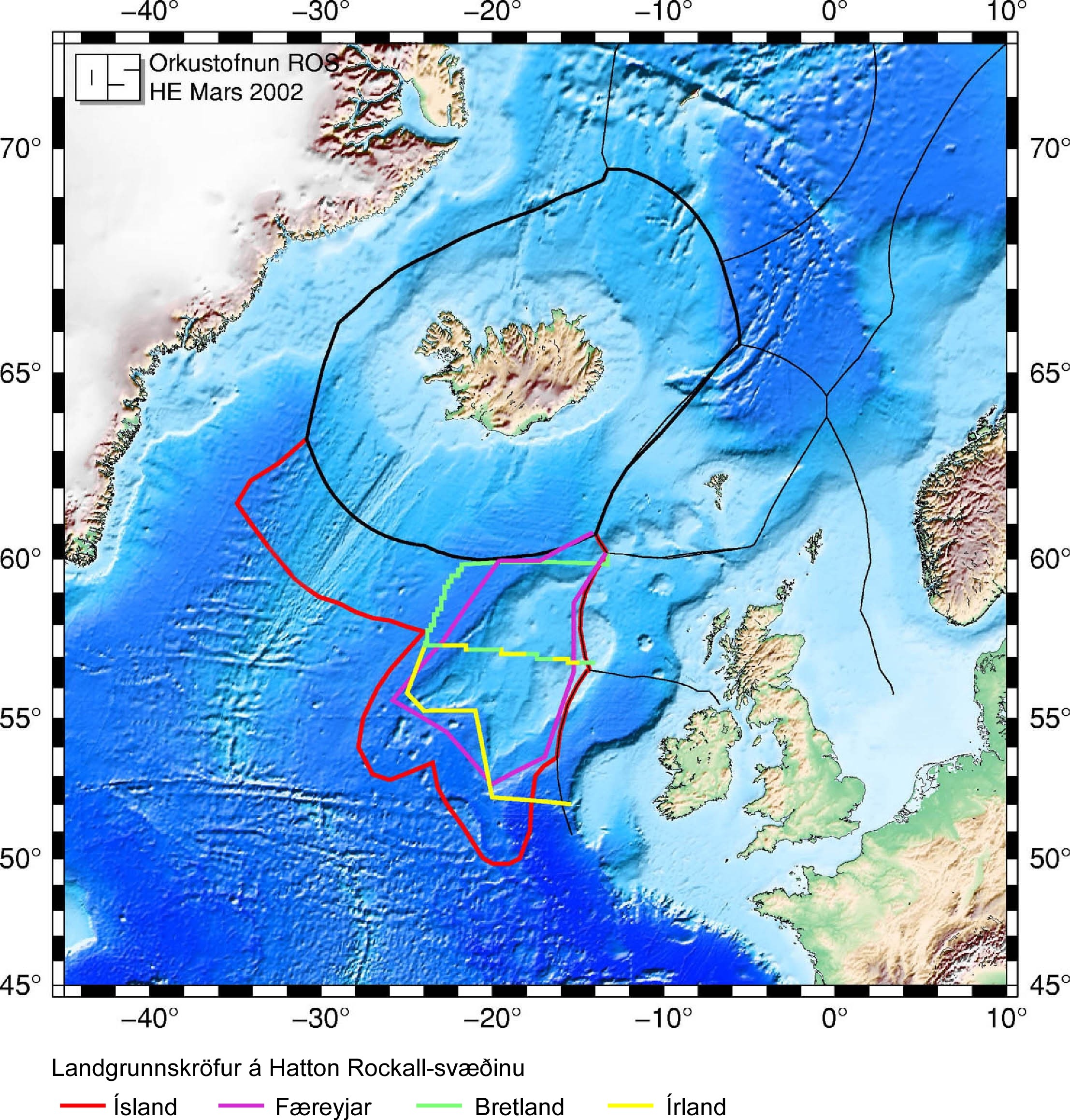