
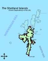
Shetland Mainland
Encyclopedia
The Mainland is the main island
of Shetland, Scotland
. The island contains Shetland's only burgh
, Lerwick
, and is the centre of Shetland's ferry
and air connections.
It has an area of 374 square miles (968.7 km²), making it the third largest Scottish island and the fifth largest of the British Isles
after Great Britain
, Ireland
, Lewis and Harris
and Skye
.
The mainland can be broadly divided into four sections.
Island
An island or isle is any piece of sub-continental land that is surrounded by water. Very small islands such as emergent land features on atolls can be called islets, cays or keys. An island in a river or lake may be called an eyot , or holm...
of Shetland, Scotland
Scotland
Scotland is a country that is part of the United Kingdom. Occupying the northern third of the island of Great Britain, it shares a border with England to the south and is bounded by the North Sea to the east, the Atlantic Ocean to the north and west, and the North Channel and Irish Sea to the...
. The island contains Shetland's only burgh
Burgh
A burgh was an autonomous corporate entity in Scotland and Northern England, usually a town. This type of administrative division existed from the 12th century, when King David I created the first royal burghs. Burgh status was broadly analogous to borough status, found in the rest of the United...
, Lerwick
Lerwick
Lerwick is the capital and main port of the Shetland Islands, Scotland, located more than 100 miles off the north coast of mainland Scotland on the east coast of the Shetland Mainland...
, and is the centre of Shetland's ferry
Ferry
A ferry is a form of transportation, usually a boat, but sometimes a ship, used to carry primarily passengers, and sometimes vehicles and cargo as well, across a body of water. Most ferries operate on regular, frequent, return services...
and air connections.
It has an area of 374 square miles (968.7 km²), making it the third largest Scottish island and the fifth largest of the British Isles
British Isles
The British Isles are a group of islands off the northwest coast of continental Europe that include the islands of Great Britain and Ireland and over six thousand smaller isles. There are two sovereign states located on the islands: the United Kingdom of Great Britain and Northern Ireland and...
after Great Britain
Great Britain
Great Britain or Britain is an island situated to the northwest of Continental Europe. It is the ninth largest island in the world, and the largest European island, as well as the largest of the British Isles...
, Ireland
Ireland
Ireland is an island to the northwest of continental Europe. It is the third-largest island in Europe and the twentieth-largest island on Earth...
, Lewis and Harris
Lewis and Harris
Lewis and Harris in the Outer Hebrides make up the largest island in Scotland. This is the largest single island of the British Isles after Great Britain and Ireland.-Geography:...
and Skye
Skye
Skye or the Isle of Skye is the largest and most northerly island in the Inner Hebrides of Scotland. The island's peninsulas radiate out from a mountainous centre dominated by the Cuillin hills...
.
The mainland can be broadly divided into four sections.
- The long southern peninsulaSouth MainlandThe South Mainland of the Shetland Islands is the part of the Mainland lying south of Hellister .*Lerwick*Scalloway*Veensgarth*Gulberwick*Quarff*Cunningsburgh*Sandwick, Shetland*Hoswick*Bigton, St Ninian's Isle*Scousburgh...
, south of Lerwick, has a mixture of moorlandMoorlandMoorland or moor is a type of habitat, in the temperate grasslands, savannas, and shrublands biome, found in upland areas, characterised by low-growing vegetation on acidic soils and heavy fog...
and farmlandArable landIn geography and agriculture, arable land is land that can be used for growing crops. It includes all land under temporary crops , temporary meadows for mowing or pasture, land under market and kitchen gardens and land temporarily fallow...
and contains many important archaeologicalArchaeologyArchaeology, or archeology , is the study of human society, primarily through the recovery and analysis of the material culture and environmental data that they have left behind, which includes artifacts, architecture, biofacts and cultural landscapes...
sites.- BigtonBigtonBigton is a small settlement on South Mainland, Shetland, UK.It lies on the Atlantic coast of the island overlooking St Ninian's Isle and within view is the island of Burra, further to the north. It is 18 miles by road from Lerwick, just off the B9122 and lies just north of the settlement of...
- SandwickSandwick, ShetlandSandwick is a township in the Shetland Islands, situated 13 miles south of Lerwick in the South Mainland. It comprises a number of distinct settlements in very close proximity to each other, each remaining distinct through being separated by agricultural land...
- ScallowayScallowayScalloway is the largest settlement on the North Atlantic coast of Mainland, Shetland with a population of approximately 812, at the 2001 census...
- SumburghSumburgh HeadSumburgh Head is located at the southern tip of the Shetland Mainland in northernScotland. The head is a 100 m high rocky spur capped by the Sumburgh Head Lighthouse. The Old Norse name was Dunrøstar høfdi, it means "The Head onto the Thunderous Noise", referring to the noise of Sumburgh Roost...
- Bigton
- The Central MainlandCentral MainlandThe Central Mainland of the Shetland Islands is the part of the Mainland, between Hellister, Aith and Voe....
has more farmland and some woodlandWoodlandEcologically, a woodland is a low-density forest forming open habitats with plenty of sunlight and limited shade. Woodlands may support an understory of shrubs and herbaceous plants including grasses. Woodland may form a transition to shrubland under drier conditions or during early stages of...
plantations. - The West MainlandWest MainlandThe West Mainland of the Shetland Islands is the part of the Mainland lying west of Aith .*Aith*Twatt*Sandness*Walls*Easter Skeld*Reawick*Wester Skeld...
- AithAithAith, , is a village on the Northern coast of the West Shetland Mainland at the southern end of Aith Voe, some 21 miles west of Lerwick....
- WallsWalls, Shetland IslandsWalls, known locally as Waas, Walls, known locally as Waas, Walls, known locally as Waas, (Old Norse: Vagar = "Sheltered Bays" (voes) - the Ordnance Survey added the "ll" as they thought it was a corruption of "walls"...
- Aith
- The North MainlandNorth MainlandThe North Mainland of the Shetland Islands is the part of the Mainland lying north of Voe .Notable places in North Mainland include:*Sullom Voe, its oil terminal being an important source of employment for the islanders.*Brae...
– in particular the large NorthmavineNorthmavineNorthmavine is a peninsula of Shetland in Scotland. It is in the north west of the island, and contains the villages of Hillswick, Ollaberry, and North Roe...
peninsula, connected to Mainland by a narrow isthmusIsthmusAn isthmus is a narrow strip of land connecting two larger land areas usually with waterforms on either side.Canals are often built through isthmuses where they may be particularly advantageous to create a shortcut for marine transportation...
at Mavis GrindMavis GrindMavis Grind is a narrow isthmus joining the Northmavine peninsula to the rest of the island of Shetland Mainland in the Shetland Islands, UK. It is just wide at its narrowest point...
– is wild, with much moorland and coastal cliffCliffIn geography and geology, a cliff is a significant vertical, or near vertical, rock exposure. Cliffs are formed as erosion landforms due to the processes of erosion and weathering that produce them. Cliffs are common on coasts, in mountainous areas, escarpments and along rivers. Cliffs are usually...
s. The North Mainland contains Sullom VoeSullom VoeSullom Voe is an inlet between North Mainland and Northmavine on Shetland in Scotland. It is a location of the Sullom Voe oil terminal. The word Voe is from the Old Norse vagr and denotes a small bay or narrow creek...
, whose oil terminal is an important source of employment for the islanders.- BraeBraeBrae is a settlement on the mainland of the Shetland Islands in Scotland. It is located at the northeast end of Busta Voe, on the narrow isthmus that separates the mainland from Northmavine...
- North RoeNorth RoeNorth Roe is a village, and protected area at the northern tip in the large Northmavine peninsula of the Mainland of Shetland, Scotland. It is a small village, with a school with less than a dozen pupils in 2011. North Roe is internationally recognised wetland site, and it is protected under the...
- VidlinVidlinVidlin , is a small village located in the Shetland Islands of Scotland.It is at the head of Vidlin Voe, is the modern heart of the old parish of Lunnasting, which centred on the early church at Lunna on Lunna Ness....
- Brae