

Pentland Firth
Encyclopedia
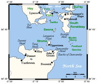
The Pentland Firth which is actually more of a strait
than a firth
, separates the Orkney Islands
from Caithness
in the north of Scotland
.
"Petlandsfjörð", meaning "the fjord of Pictland", and is completely unrelated to the Pentland Hills
near Edinburgh
.
Prior to the Norse occupation of Orkney the strait was known as the "Sea of Orcs" - a reference to the Pictish
tribe who inhabited Orkney. Such was their marine prowess that there are also instances of this name referring to the sea lanes of the entire west coast of Scotland down to Kintyre
. One version of the 9th century Historia Brittonum states that "the Britons originally filled the whole island with their peoples from the English Channel to the Sea of Orcs".
in the west to Duncansby Head in the east, while on the Orkney (northern) side from Tor Ness on Hoy in the west to Old Head on South Ronaldsay in the east.
In the middle of the Firth are two significant islands, Stroma
and Swona
. The small Pentland Skerries
group are in the east. The islands of Hoy
and South Ronaldsay
border the firth to the north and are part of the Orkney Islands
.
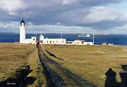
The most northerly point of the headland
of Dunnet Head, Easter Head, is also that of mainland Britain
. The famous John o' Groats
, Mey
(site of the Castle of Mey
), and many smaller villages are also to be found on the Caithness side as is the town of Thurso
and Scrabster Harbour
in Thurso Bay
, on the western fringe of the Firth.
operated by Northlink is the oldest continuous ferry service across the firth by the ferry MV Hamnavoe
, started in 1856 as a continuation of the railhead at Thurso
.
Historically the Gills Bay area has been the main setting off point from the mainland to the islands of Stroma
and Swona
and Orkney itself. This route, known as The Short Sea Crossing, is both the quickest and safest route across the stormy waters of the Pentland Firth. At present Pentland Ferries
operate on this route from Gills Bay
to St Margaret's Hope
on South Ronaldsay
.
At the Eastern end John o' Groats Ferries sail to Burwick, also on South Ronaldsay
. This is a small passenger ferry and is run in the summer months only.
s are:
In addition to ‘The Swelkie’, races form at both the north and south ends of Stroma and Swona. Between the races there is a calm eddy which extends down tide as the tide strengthens. The races are highly visible with overfalls and whirlpools. Large swell waves can also be present, especially in bad weather conditions. When entering or leaving the eddies, crossing the races, even large powerful vessels can be pushed off course, such is the demarcation between the relatively calm eddy and the fast-moving tide in the races. There are other races in the firth particularly off Brough Head.
of tidal power" and may be capable of accommodating 10 GW of installed generating capacity. This is up to 25% of the estimated total capacity for the European Union
.
In October 2008 tidal power developer Atlantis Resources Corporation announced it was considering a site near the Castle of Mey
for a computer data centre that would be powered by a tidal scheme in the Firth.
In October 2010 MeyGen, a consortium of Morgan Stanley
, Atlantis Resources Corporation and International Power
, received operational lease from the Crown Estate
to a 400MW project for 25 years.
 Seals
Seals
can be seen at all times of the year in all parts of the firth. They usually bask on the rocks on the ebb (falling) tide since it saves them having to move as the water rises. Large groups of seals can be seen at the north of Stroma
, from the lighthouse round to the north-west part of the island and at the south end in the area of the beacon and to the east between the old jetty and the lighthouse. On Swona
they can be seen around the mid point of the west coast.
The Common Seal
come in various colours with spots and have their pups in May, June and July. They are of a similar colour to the adults and can swim from birth, The Gray Seal, which is more common in this area having one of the largest British populations, also comes in a number of colours and live in colonies giving birth to white pups from October through to January. These pups do not swim at first until they shed their white coat. When giving birth seals can often be seen inland, sometimes quite a surprising distance.
Porpoise
s. Again can be seen all year round in all parts of the firth although they tend to favour shallower water. Grow to about 1.5m, black, with a broad based triangular fin which can be seen as they surface. It has a small, rotund body with a short, blunt head, no beak, and a small, triangular dorsal fin. Usually seen singly or in small numbers although in the autumn many groups may be seen in Gills Bay
. When in groups tend to swim in a more random fashion than Dolphins who swim together.
Dolphin
s. Not very common but seen from time to time. Many different types visit the firth and may be seen anywhere at any time. Larger than Porpoises, 2-3m depending on the type, black, with the rear edge of the fin curved back at the top unlike the straight edge of the Porpoise. Head has a distinct beak. Often swim alongside the bow of vessels and frolic in the bow waves. Probably more than one usually swimming together in a more synchronised manner, sometimes leaping out of the water.
Killer Whale. Mostly seen around May to July although may be sighted at any time of the year. Usually swim in a pod of a maximum of from six to twelve individuals led by a male up to 9m long who will be about 25% larger than the females and juveniles who make up the remainder of the pod. They tend to be fairly distinctive due to their size, fin and markings. The male has a very tall, triangular and erect dorsal fin which is sometimes tilted forwards. Juveniles and adult females both have a smaller, sickle-shaped dorsal fin. When surfacing the grey saddle shows up over the black back, behind the dorsal fin. It has a conical-shaped black head, with a distinctive white oval patch above and behind the eye, an indistinct beak, white throat and large paddle-shaped flippers.
Minke whale
. Quite often seen in June and occasionally through to October but also at other times of the year. Tend to feed in the up-welling water of the tidal races but can be seen elsewhere. Usually seen singly but may be in pairs. Grows to 7-8.5m, black with diagonal white band on flipper and a slender, pointed triangular head. Relatively small dorsal fin curved back at top at rear part of body. Will probably see the long back with small fin to rear breaking the surface although they are known to bow and stern ride the waves of vessels.
Basking shark
. Rare but being seen more often around May to August. A fish rather than a marine mammal spends most of its time cruising on the surface filter feeding. The dorsal fin can be seen moving steadily through the water with the tip of the tail moving from side to side behind it. Usually seen feeding inshore at high tide around here in the Gills Bay
, Stroma
area though may be seen in deeper water. Generally around 8m long, greyish brown to bluish black with pale belly. Seen in northern waters in the summer, southern in winter. Often in groups of three or four.
Turtle
s. Very rarely seen, however they are occasionally found caught in fishing nets in this area. The Leatherback is the most frequently recorded species in UK waters and probably the only one in this area. Grows to about 2.9m with an elongated black shell spotted with white, which tapers to a blunt spike. Migrates to UK waters from the tropics in the summer to feed on jellyfish. There are four other species less frequently encountered in UK waters where they usually occur as stray juveniles carried by currents from warmer seas.
Strait
A strait or straits is a narrow, typically navigable channel of water that connects two larger, navigable bodies of water. It most commonly refers to a channel of water that lies between two land masses, but it may also refer to a navigable channel through a body of water that is otherwise not...
than a firth
Firth
Firth is the word in the Lowland Scots language and in English used to denote various coastal waters in Scotland and England. In mainland Scotland it is used to describe a large sea bay, or even a strait. In the Northern Isles it more usually refers to a smaller inlet...
, separates the Orkney Islands
Orkney Islands
Orkney also known as the Orkney Islands , is an archipelago in northern Scotland, situated north of the coast of Caithness...
from Caithness
Caithness
Caithness is a registration county, lieutenancy area and historic local government area of Scotland. The name was used also for the earldom of Caithness and the Caithness constituency of the Parliament of the United Kingdom . Boundaries are not identical in all contexts, but the Caithness area is...
in the north of Scotland
Scotland
Scotland is a country that is part of the United Kingdom. Occupying the northern third of the island of Great Britain, it shares a border with England to the south and is bounded by the North Sea to the east, the Atlantic Ocean to the north and west, and the North Channel and Irish Sea to the...
.
Etymology
The name is presumed to be a corruption of the Old NorseOld Norse
Old Norse is a North Germanic language that was spoken by inhabitants of Scandinavia and inhabitants of their overseas settlements during the Viking Age, until about 1300....
"Petlandsfjörð", meaning "the fjord of Pictland", and is completely unrelated to the Pentland Hills
Pentland Hills
The Pentland Hills are a range of hills to the south-west of Edinburgh, Scotland. The range is around 20 miles in length, and runs south west from Edinburgh towards Biggar and the upper Clydesdale.Some of the peaks include:* Scald Law...
near Edinburgh
Edinburgh
Edinburgh is the capital city of Scotland, the second largest city in Scotland, and the eighth most populous in the United Kingdom. The City of Edinburgh Council governs one of Scotland's 32 local government council areas. The council area includes urban Edinburgh and a rural area...
.
Prior to the Norse occupation of Orkney the strait was known as the "Sea of Orcs" - a reference to the Pictish
Picts
The Picts were a group of Late Iron Age and Early Mediaeval people living in what is now eastern and northern Scotland. There is an association with the distribution of brochs, place names beginning 'Pit-', for instance Pitlochry, and Pictish stones. They are recorded from before the Roman conquest...
tribe who inhabited Orkney. Such was their marine prowess that there are also instances of this name referring to the sea lanes of the entire west coast of Scotland down to Kintyre
Kintyre
Kintyre is a peninsula in western Scotland, in the southwest of Argyll and Bute. The region stretches approximately 30 miles , from the Mull of Kintyre in the south, to East Loch Tarbert in the north...
. One version of the 9th century Historia Brittonum states that "the Britons originally filled the whole island with their peoples from the English Channel to the Sea of Orcs".
Geography
On the Caithness (southern) side the Firth extends from Dunnet HeadDunnet Head
Dunnet Head is a peninsula in Caithness, on the north coast of Scotland, that includes the most northerly point of the mainland of Great Britain. The point, known as Easter Head, is at , about westnorthwest of John o' Groats and about from Duncansby Head...
in the west to Duncansby Head in the east, while on the Orkney (northern) side from Tor Ness on Hoy in the west to Old Head on South Ronaldsay in the east.
In the middle of the Firth are two significant islands, Stroma
Stroma, Scotland
Stroma is an island off the northern coast of the Scottish mainland. It is the more southerly of the two islands in the Pentland Firth between the Orkney Islands and Caithness. It is administratively part of Caithness , while its neighbour Swona, to the north, is part of the Orkney Islands...
and Swona
Swona
Swona is an uninhabited island in the Pentland Firth off the north coast of Scotland.-Geography and geology:Swona is the more northerly of two islands in the Pentland Firth between the Orkney Islands and Caithness on the Scottish mainland...
. The small Pentland Skerries
Pentland Skerries
The Pentland Skerries are a group of four uninhabited islands lying in the Pentland Firth, northeast of Duncansby Head and south of South Ronaldsay in Scotland....
group are in the east. The islands of Hoy
Hoy
Hoy is an island in Orkney, Scotland. With an area of it is the second largest in the archipelago after the Mainland. It is connected by a causeway called The Ayre to South Walls...
and South Ronaldsay
South Ronaldsay
South Ronaldsay is one of the Orkney Islands off the north coast of Scotland. It is linked to the Orkney Mainland by the Churchill Barriers, running via Burray, Glimps Holm and Lamb Holm.-Geography and geology:...
border the firth to the north and are part of the Orkney Islands
Orkney Islands
Orkney also known as the Orkney Islands , is an archipelago in northern Scotland, situated north of the coast of Caithness...
.
The most northerly point of the headland
Headlands and bays
Headlands and bays are two related features of the coastal environment.- Geology and geography :Headlands and bays are often found on the same coastline. A bay is surrounded by land on three sides, whereas a headland is surrounded by water on three sides. Headlands are characterized by high,...
of Dunnet Head, Easter Head, is also that of mainland Britain
Great Britain
Great Britain or Britain is an island situated to the northwest of Continental Europe. It is the ninth largest island in the world, and the largest European island, as well as the largest of the British Isles...
. The famous John o' Groats
John o' Groats
John o' Groats is a village in the Highland council area of Scotland. Part of the county of Caithness, John o' Groats is popular with tourists because it is usually regarded as the most northerly settlement of mainland Great Britain, although this is not a claim made by the inhabitants...
, Mey
Mey
Mey or Mei may refer to:People*Cornelius Jacobsen Mey, early 17th century Dutch explorer*Lev Mei , Russian dramatist and poet*Marie-Anett Mey , French musician*Melis Karin Mey , Turkish long jumper...
(site of the Castle of Mey
Castle of Mey
The Castle of Mey is located in Caithness, on the north coast of Scotland, about west of John o' Groats. In fine weather there are views from the castle north to the Orkney Islands.-History:...
), and many smaller villages are also to be found on the Caithness side as is the town of Thurso
Thurso
-Facilities:Offices of the Highland Council are located in the town, as is the main campus of North Highland College, formerly Thurso College. This is one of several partner colleges which constitute the UHI Millennium Institute, and offers several certificate, diploma and degree courses from...
and Scrabster Harbour
Scrabster Harbour
Scrabster is a small settlement on Thurso Bay in Caithness on the north coast of Scotland. It is some 1½ miles from Thurso, 22½ miles from Wick and 112 miles from Inverness....
in Thurso Bay
Thurso Bay
Thurso Bay, known also as Scrabster Bay, is a bay of Atlantic water between the points of Clairdon Head and Holborn Head on the north coast of Caithness, Scotland....
, on the western fringe of the Firth.
Crossing the Firth
In the West the ferry from Scrabster to StromnessStromness
Stromness is the second-biggest town in Orkney, Scotland. It is in the south-west of Mainland Orkney. It is also a parish, with the town of Stromness as its capital.-Etymology:...
operated by Northlink is the oldest continuous ferry service across the firth by the ferry MV Hamnavoe
MV Hamnavoe
Northlink Ferries' car and passenger ferry, MV Hamnavoe operates across the Pentland Firth to Orkney.-History:MV Hamnavoe was introduced to the service in 2003, the first ferry to have been specifically built for the Pentland Firth route...
, started in 1856 as a continuation of the railhead at Thurso
Thurso
-Facilities:Offices of the Highland Council are located in the town, as is the main campus of North Highland College, formerly Thurso College. This is one of several partner colleges which constitute the UHI Millennium Institute, and offers several certificate, diploma and degree courses from...
.
Historically the Gills Bay area has been the main setting off point from the mainland to the islands of Stroma
Stroma, Scotland
Stroma is an island off the northern coast of the Scottish mainland. It is the more southerly of the two islands in the Pentland Firth between the Orkney Islands and Caithness. It is administratively part of Caithness , while its neighbour Swona, to the north, is part of the Orkney Islands...
and Swona
Swona
Swona is an uninhabited island in the Pentland Firth off the north coast of Scotland.-Geography and geology:Swona is the more northerly of two islands in the Pentland Firth between the Orkney Islands and Caithness on the Scottish mainland...
and Orkney itself. This route, known as The Short Sea Crossing, is both the quickest and safest route across the stormy waters of the Pentland Firth. At present Pentland Ferries
Pentland Ferries
Pentland Ferries is a privately owned, family company which has operated a ferry service between Gills Bay in Caithness, Scotland and St Margaret's Hope on South Ronaldsay in Orkney since May 2001.-History:...
operate on this route from Gills Bay
Gills Bay
Gills Bay, which is situated some 3mls. West of John o' Groats with the community of Gills close by, has one of the longest stretches of low-lying rock coast on the northern shores of Caithness. Its main features are a small harbour and the pier used as the mainland terminal for Pentland Ferries...
to St Margaret's Hope
St Margaret's Hope
St Margaret's Hope, known locally as The Hope , is a village in the Orkney Islands, situated off the north-east coast of Scotland. It has a population of about 550, making it Orkney's third largest settlement after Kirkwall and Stromness....
on South Ronaldsay
South Ronaldsay
South Ronaldsay is one of the Orkney Islands off the north coast of Scotland. It is linked to the Orkney Mainland by the Churchill Barriers, running via Burray, Glimps Holm and Lamb Holm.-Geography and geology:...
.
At the Eastern end John o' Groats Ferries sail to Burwick, also on South Ronaldsay
South Ronaldsay
South Ronaldsay is one of the Orkney Islands off the north coast of Scotland. It is linked to the Orkney Mainland by the Churchill Barriers, running via Burray, Glimps Holm and Lamb Holm.-Geography and geology:...
. This is a small passenger ferry and is run in the summer months only.
Tidal races
The Firth is well known for the strength of its tides, being among some of the fastest in the world, a speed of 16 knots (30 km/h) being reported close west of Pentland Skerries. The force of the tides gives rise to overfalls and tidal races which can occur at different stages of the tide. Some of the principal tidal raceTidal race
Tidal race is a natural occurrence whereby a fast moving tide passes through a constriction resulting in the formation of waves, eddies and hazardous currents...
s are:
- ‘The Merry Men of Mey’. Forms off St John’s point in the west-going stream and extends as the tide increases NNW across the firth to Tor Ness. The worst part is over a sand wave field about 3½ miles (5.6 km) west of Stroma. The waves formed by this race form a natural breakwater with relatively calm water to the east of it, particularly noticeable when a westerly swell is running. Tides in this area can exceed 10 kts (18.5 km/h).
- ‘The Swelkie’. The race at the north end of Stroma, off Swelkie Point is known as ‘The Swelkie’. It extends from the point in an easterly or westerly direction depending on the tide and can be particularly violent. The whirlpoolWhirlpoolA whirlpool is a swirling body of water usually produced by ocean tides. The vast majority of whirlpools are not very powerful. More powerful ones are more properly termed maelstroms. Vortex is the proper term for any whirlpool that has a downdraft...
of the same name was, according to a VikingVikingThe term Viking is customarily used to refer to the Norse explorers, warriors, merchants, and pirates who raided, traded, explored and settled in wide areas of Europe, Asia and the North Atlantic islands from the late 8th to the mid-11th century.These Norsemen used their famed longships to...
legend, caused by a sea-witch turning the mill wheels which ground the salt to keep the seas salty. The name derives from an Old NorseOld NorseOld Norse is a North Germanic language that was spoken by inhabitants of Scandinavia and inhabitants of their overseas settlements during the Viking Age, until about 1300....
term, Svalga meaning "the Swallower".
- The ‘Duncansby Race’ forms off Ness of Duncansby at the start of the SE-going tidal stream (flood). Initially extending ENE but wheeling gradually anti-clockwise until it extends about 1 ml. (1.6 km) NW some 2½ hrs later at which point it is known as ‘The Boars of Duncansby’. During the time of the SE stream there is additional turbulence off Duncansby Head, particularly to the East. The race temporarily ceases at the turn of the tide before forming in an ENE direction in the NW-going tidal stream (Ebb) before ceasing again at the next turn of the tide. The race is particularly violent and dangerous when the tidal stream is opposed by gales in the opposite direction. During the east-going stream a race forms off Ness of Huna. This race can be particularly violent in an easterly or southeasterly gale.
- The ‘Liddel Eddy’ forms between South Ronaldsay and Muckle Skerry in the East-going stream (flood). A race also forms for part of the time off Old Head at the SE part of South Ronaldsay.
In addition to ‘The Swelkie’, races form at both the north and south ends of Stroma and Swona. Between the races there is a calm eddy which extends down tide as the tide strengthens. The races are highly visible with overfalls and whirlpools. Large swell waves can also be present, especially in bad weather conditions. When entering or leaving the eddies, crossing the races, even large powerful vessels can be pushed off course, such is the demarcation between the relatively calm eddy and the fast-moving tide in the races. There are other races in the firth particularly off Brough Head.
Tidal power
The potential economic significance of the tidal currents in the Pentland Firth is great. It has been described as the "Saudi ArabiaSaudi Arabia
The Kingdom of Saudi Arabia , commonly known in British English as Saudi Arabia and in Arabic as as-Sa‘ūdiyyah , is the largest state in Western Asia by land area, constituting the bulk of the Arabian Peninsula, and the second-largest in the Arab World...
of tidal power" and may be capable of accommodating 10 GW of installed generating capacity. This is up to 25% of the estimated total capacity for the European Union
European Union
The European Union is an economic and political union of 27 independent member states which are located primarily in Europe. The EU traces its origins from the European Coal and Steel Community and the European Economic Community , formed by six countries in 1958...
.
In October 2008 tidal power developer Atlantis Resources Corporation announced it was considering a site near the Castle of Mey
Castle of Mey
The Castle of Mey is located in Caithness, on the north coast of Scotland, about west of John o' Groats. In fine weather there are views from the castle north to the Orkney Islands.-History:...
for a computer data centre that would be powered by a tidal scheme in the Firth.
In October 2010 MeyGen, a consortium of Morgan Stanley
Morgan Stanley
Morgan Stanley is a global financial services firm headquartered in New York City serving a diversified group of corporations, governments, financial institutions, and individuals. Morgan Stanley also operates in 36 countries around the world, with over 600 offices and a workforce of over 60,000....
, Atlantis Resources Corporation and International Power
International Power
International Power PLC is an international electricity generator formed in 2000 by the demerger of National Power. It is headquartered at Senator House, 85 Queen Victoria Street in the City of London...
, received operational lease from the Crown Estate
Crown Estate
In the United Kingdom, the Crown Estate is a property portfolio owned by the Crown. Although still belonging to the monarch and inherent with the accession of the throne, it is no longer the private property of the reigning monarch and cannot be sold by him/her, nor do the revenues from it belong...
to a 400MW project for 25 years.
Marine wildlife
Pinniped
Pinnipeds or fin-footed mammals are a widely distributed and diverse group of semiaquatic marine mammals comprising the families Odobenidae , Otariidae , and Phocidae .-Overview: Pinnipeds are typically sleek-bodied and barrel-shaped...
can be seen at all times of the year in all parts of the firth. They usually bask on the rocks on the ebb (falling) tide since it saves them having to move as the water rises. Large groups of seals can be seen at the north of Stroma
Stroma, Scotland
Stroma is an island off the northern coast of the Scottish mainland. It is the more southerly of the two islands in the Pentland Firth between the Orkney Islands and Caithness. It is administratively part of Caithness , while its neighbour Swona, to the north, is part of the Orkney Islands...
, from the lighthouse round to the north-west part of the island and at the south end in the area of the beacon and to the east between the old jetty and the lighthouse. On Swona
Swona
Swona is an uninhabited island in the Pentland Firth off the north coast of Scotland.-Geography and geology:Swona is the more northerly of two islands in the Pentland Firth between the Orkney Islands and Caithness on the Scottish mainland...
they can be seen around the mid point of the west coast.
The Common Seal
Harbor Seal
The harbor seal , also known as the common seal, is a true seal found along temperate and Arctic marine coastlines of the Northern Hemisphere...
come in various colours with spots and have their pups in May, June and July. They are of a similar colour to the adults and can swim from birth, The Gray Seal, which is more common in this area having one of the largest British populations, also comes in a number of colours and live in colonies giving birth to white pups from October through to January. These pups do not swim at first until they shed their white coat. When giving birth seals can often be seen inland, sometimes quite a surprising distance.
Porpoise
Porpoise
Porpoises are small cetaceans of the family Phocoenidae; they are related to whales and dolphins. They are distinct from dolphins, although the word "porpoise" has been used to refer to any small dolphin, especially by sailors and fishermen...
s. Again can be seen all year round in all parts of the firth although they tend to favour shallower water. Grow to about 1.5m, black, with a broad based triangular fin which can be seen as they surface. It has a small, rotund body with a short, blunt head, no beak, and a small, triangular dorsal fin. Usually seen singly or in small numbers although in the autumn many groups may be seen in Gills Bay
Gills Bay
Gills Bay, which is situated some 3mls. West of John o' Groats with the community of Gills close by, has one of the longest stretches of low-lying rock coast on the northern shores of Caithness. Its main features are a small harbour and the pier used as the mainland terminal for Pentland Ferries...
. When in groups tend to swim in a more random fashion than Dolphins who swim together.
Dolphin
Dolphin
Dolphins are marine mammals that are closely related to whales and porpoises. There are almost forty species of dolphin in 17 genera. They vary in size from and , up to and . They are found worldwide, mostly in the shallower seas of the continental shelves, and are carnivores, mostly eating...
s. Not very common but seen from time to time. Many different types visit the firth and may be seen anywhere at any time. Larger than Porpoises, 2-3m depending on the type, black, with the rear edge of the fin curved back at the top unlike the straight edge of the Porpoise. Head has a distinct beak. Often swim alongside the bow of vessels and frolic in the bow waves. Probably more than one usually swimming together in a more synchronised manner, sometimes leaping out of the water.
Killer Whale. Mostly seen around May to July although may be sighted at any time of the year. Usually swim in a pod of a maximum of from six to twelve individuals led by a male up to 9m long who will be about 25% larger than the females and juveniles who make up the remainder of the pod. They tend to be fairly distinctive due to their size, fin and markings. The male has a very tall, triangular and erect dorsal fin which is sometimes tilted forwards. Juveniles and adult females both have a smaller, sickle-shaped dorsal fin. When surfacing the grey saddle shows up over the black back, behind the dorsal fin. It has a conical-shaped black head, with a distinctive white oval patch above and behind the eye, an indistinct beak, white throat and large paddle-shaped flippers.
Minke whale
Minke Whale
Minke whale , or lesser rorqual, is a name given to two species of marine mammal belonging to a clade within the suborder of baleen whales. The minke whale was given its official designation by Lacepède in 1804, who described a dwarf form of Balænoptera acuto-rostrata...
. Quite often seen in June and occasionally through to October but also at other times of the year. Tend to feed in the up-welling water of the tidal races but can be seen elsewhere. Usually seen singly but may be in pairs. Grows to 7-8.5m, black with diagonal white band on flipper and a slender, pointed triangular head. Relatively small dorsal fin curved back at top at rear part of body. Will probably see the long back with small fin to rear breaking the surface although they are known to bow and stern ride the waves of vessels.
Basking shark
Basking shark
The basking shark is the second largest living fish, after the whale shark. It is a cosmopolitan migratory species, found in all the world's temperate oceans. It is a slow moving and generally harmless filter feeder and has anatomical adaptations to filter feeding, such as a greatly enlarged...
. Rare but being seen more often around May to August. A fish rather than a marine mammal spends most of its time cruising on the surface filter feeding. The dorsal fin can be seen moving steadily through the water with the tip of the tail moving from side to side behind it. Usually seen feeding inshore at high tide around here in the Gills Bay
Gills Bay
Gills Bay, which is situated some 3mls. West of John o' Groats with the community of Gills close by, has one of the longest stretches of low-lying rock coast on the northern shores of Caithness. Its main features are a small harbour and the pier used as the mainland terminal for Pentland Ferries...
, Stroma
Stroma, Scotland
Stroma is an island off the northern coast of the Scottish mainland. It is the more southerly of the two islands in the Pentland Firth between the Orkney Islands and Caithness. It is administratively part of Caithness , while its neighbour Swona, to the north, is part of the Orkney Islands...
area though may be seen in deeper water. Generally around 8m long, greyish brown to bluish black with pale belly. Seen in northern waters in the summer, southern in winter. Often in groups of three or four.
Turtle
Turtle
Turtles are reptiles of the order Testudines , characterised by a special bony or cartilaginous shell developed from their ribs that acts as a shield...
s. Very rarely seen, however they are occasionally found caught in fishing nets in this area. The Leatherback is the most frequently recorded species in UK waters and probably the only one in this area. Grows to about 2.9m with an elongated black shell spotted with white, which tapers to a blunt spike. Migrates to UK waters from the tropics in the summer to feed on jellyfish. There are four other species less frequently encountered in UK waters where they usually occur as stray juveniles carried by currents from warmer seas.