

List of Outer Hebrides
Encyclopedia

Outer Hebrides
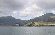
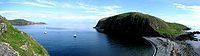
The Outer Hebrides also known as the Western Isles and the Long Island, is an island chain off the west coast of Scotland. The islands are geographically contiguous with Comhairle nan Eilean Siar, one of the 32 unitary council areas of Scotland...
is a chain of more than 100 islands and small skerries
Skerry
A skerry is a small rocky island, usually defined to be too small for habitation. It may simply be a rocky reef. A skerry can also be called a low sea stack....
located about 70 kilometres (43.5 mi) west of mainland Scotland
Scotland
Scotland is a country that is part of the United Kingdom. Occupying the northern third of the island of Great Britain, it shares a border with England to the south and is bounded by the North Sea to the east, the Atlantic Ocean to the north and west, and the North Channel and Irish Sea to the...
. There are 15 inhabited islands in this archipelago
Archipelago
An archipelago , sometimes called an island group, is a chain or cluster of islands. The word archipelago is derived from the Greek ἄρχι- – arkhi- and πέλαγος – pélagos through the Italian arcipelago...
, which is also known as the Western Isles and archaically as the Long Isle .
Lewis and Harris
Lewis and Harris
Lewis and Harris in the Outer Hebrides make up the largest island in Scotland. This is the largest single island of the British Isles after Great Britain and Ireland.-Geography:...
is the largest island in Scotland and the third largest in the British Isles
British Isles
The British Isles are a group of islands off the northwest coast of continental Europe that include the islands of Great Britain and Ireland and over six thousand smaller isles. There are two sovereign states located on the islands: the United Kingdom of Great Britain and Northern Ireland and...
, after Great Britain and Ireland. It incorporates Lewis
Lewis
Lewis is the northern part of Lewis and Harris, the largest island of the Western Isles or Outer Hebrides of Scotland. The total area of Lewis is ....
in the north and Harris in the south, both of which are frequently referred to as individual islands, although they are joined by a land border. The largest settlement in Lewis and in the Outer Hebrides is Stornoway
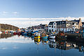
Stornoway
Stornoway is a burgh on the Isle of Lewis, in the Outer Hebrides of Scotland.The town's population is around 9,000, making it the largest settlement in the Western Isles and the third largest town in the Scottish Highlands after Inverness and Fort William...
.
To the south across the Sound of Harris lie the Uists and Benbecula
Benbecula
Benbecula is an island of the Outer Hebrides in the Atlantic Ocean off the west coast of Scotland. In the 2001 census it had a usually resident population of 1,249, with a sizable percentage of Roman Catholics. It forms part of the area administered by Comhairle nan Eilean Siar or the Western...
, which were joined by a series of causeways constructed between 1940 and 1960 to improve transport links. Further south are Barra
Barra
The island of Barra is a predominantly Gaelic-speaking island, and apart from the adjacent island of Vatersay, to which it is connected by a causeway, is the southernmost inhabited island of the Outer Hebrides in Scotland.-Geography:The 2001 census showed that the resident population was 1,078...
and the smaller Barra Isles
Barra Isles
The Barra Isles, also known as the Bishop's Isles as they were historically owned by the Bishop of the Isles, are a small archipelago of islands in the Outer Hebrides of Scotland. They lie south of the island of Barra, for which they are named. The group consists of nine islands, and numerous...
, whose southernmost extremity is Barra Head
Barra Head
Barra Head, also known as Berneray , is the southernmost of the Outer Hebrides in Scotland. Within the Outer Hebrides, it forms part of the Barra Isles archipelago. Originally, Barra Head only referred to the southernmost headland of Berneray but is now a common name for the entire island...
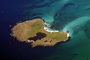
. There are other outliers with cultural links to the Outer Hebrides that are not part of the archipelago itself. These include the St Kilda
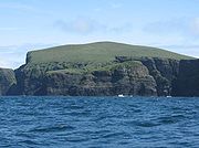
St Kilda, Scotland
St Kilda is an isolated archipelago west-northwest of North Uist in the North Atlantic Ocean. It contains the westernmost islands of the Outer Hebrides of Scotland. The largest island is Hirta, whose sea cliffs are the highest in the United Kingdom and three other islands , were also used for...
group, which are quite distinct geologically and no longer inhabited, Sula Sgeir
Sula Sgeir
Sula Sgeir is a small, uninhabited Scottish island in the North Atlantic, west of North Rona...
and North Rona
North Rona
Rona is a remote Scottish island in the North Atlantic. Rona is often referred to as North Rona in order to distinguish it from South Rona . It has an area of and a maximum height of...
to the north and isolated Rockall
Rockall
Rockall is an extremely small, uninhabited, remote rocky islet in the North Atlantic Ocean. It gives its name to one of the sea areas named in the shipping forecast provided by the British Meteorological Office....
, which is 367 kilometres (228 mi) to the west of North Uist
North Uist
North Uist is an island and community in the Outer Hebrides of Scotland.-Geography:North Uist is the tenth largest Scottish island and the thirteenth largest island surrounding Great Britain. It has an area of , slightly smaller than South Uist. North Uist is connected by causeways to Benbecula...
.
The islands of Scotland's west coast are known collectively as the Hebrides and the Outer Hebrides
Outer Hebrides
The Outer Hebrides also known as the Western Isles and the Long Island, is an island chain off the west coast of Scotland. The islands are geographically contiguous with Comhairle nan Eilean Siar, one of the 32 unitary council areas of Scotland...
are separated from the Inner Hebrides
Inner Hebrides
The Inner Hebrides is an archipelago off the west coast of Scotland, to the south east of the Outer Hebrides. Together these two island chains form the Hebrides, which enjoy a mild oceanic climate. There are 36 inhabited islands and a further 43 uninhabited Inner Hebrides with an area greater than...
by The Minch
The Minch
The Minch , also called The North Minch, is a strait in north-west Scotland, separating the north-west Highlands, and the northern Inner Hebrides, from Lewis and Harris in the Outer Hebrides...
to the north and the Sea of the Hebrides
Sea of the Hebrides
The Sea of the Hebrides is a portion of the North Atlantic Ocean, located off the coast of western Scotland, separating the mainland and the northern Inner Hebrides islands from the southern Outer Hebrides islands...
to the south. The Outer Hebrides are administered by Comhairle nan Eilean Siar
Comhairle nan Eilean Siar
Comhairle nan Eilean Siar is the local government council for Na h-Eileanan Siar council area of Scotland.It is the only local council in Scotland to have a Gaelic-only name...
and had a population of 26,502 in 2001. The Outer Hebrides have historically been a strong Scottish Gaelic (Gàidhlig) speaking area. Despite recent declines, in the 2001 census more than 50% of the resident population in each island was able to speak Gaelic, for an overall total of 15,842 speakers throughout the archipelago. The modern economy centres on tourism, crofting
Croft (land)
A croft is a fenced or enclosed area of land, usually small and arable with a crofter's dwelling thereon. A crofter is one who has tenure and use of the land, typically as a tenant farmer.- Etymology :...
, fishing, and weaving, the latter of which includes the manufacture of Harris tweed
Harris Tweed
Harris Tweed is a cloth that has been handwoven by the islanders on the Isles of Harris, Lewis, Uist and Barra in the Outer Hebrides of Scotland, using local wool....
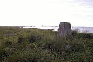
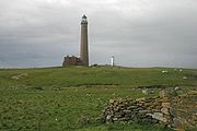
. The archipelago is exposed to wind and tide, and there are numerous lighthouse
Lighthouse
A lighthouse is a tower, building, or other type of structure designed to emit light from a system of lamps and lenses or, in older times, from a fire, and used as an aid to navigation for maritime pilots at sea or on inland waterways....
s as an aid to navigation.
The definition of an island used in this list is that it is "land that is surrounded by seawater on a daily basis, but not necessarily at all stages of the tide, excluding human devices such as bridges and causeways".
Inhabited islands

The highest peaks of the islands have names deriving from both Gaelic and Old Norse
Old Norse
Old Norse is a North Germanic language that was spoken by inhabitants of Scandinavia and inhabitants of their overseas settlements during the Viking Age, until about 1300....
indicating the historical importance of these two cultures. The archeological record for the period of Viking domination during the Early Historic
Middle Ages
The Middle Ages is a periodization of European history from the 5th century to the 15th century. The Middle Ages follows the fall of the Western Roman Empire in 476 and precedes the Early Modern Era. It is the middle period of a three-period division of Western history: Classic, Medieval and Modern...
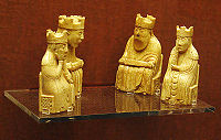
period is however very limited, the Lewis chessmen
Lewis chessmen
The Lewis Chessmen are a group of 78 12th-century chess pieces, most of which are carved in walrus ivory...
being an exception.
In addition to the North Ford (Oitir Mhòr) and South Ford causeways which connect North and South Uist, Benbecula and the northern of the two Grimsay
Grimsay
Grimsay is a tidal island in the Outer Hebrides of Scotland.Grimsay is the largest of the low-lying stepping-stones which convey the Oitir Mhòr causeway, a five mile arc of single track road linking North Uist and Benbecula via the western tip of Grimsay...
s in the southern part of the island chain, several other islands are now connected by causeways and bridges. Great Bernera
Great Bernera
Great Bernera , often known just as Bernera is an island and community in the Outer Hebrides of Scotland. With an area of just over , it is the thirty-fourth largest Scottish island....
and Scalpay
Scalpay, Outer Hebrides
Scalpay to distinguish it from the other Scalpay) is an island and community in the Outer Hebrides of Scotland.-Geography:Scalpay is around 2.5 miles long and rises to a height of 341 ft at Beinn Scorabhaig. Scalpay's nearest neighbour, Harris is just 330 yds away over narrow Caolas...
have bridge connections to Lewis and Harris respectively, Baleshare
Baleshare
Baleshare is a flat tidal island in the Outer Hebrides of Scotland.Baleshare lies to the south-west of North Uist. Its economics and community were boosted by the building of a causeway in 1962. The 350m causeway was built by William Tawse Ltd. The island is extremely flat by Hebridean standards,...
and Berneray
Berneray, North Uist
Berneray is an island and community in the Sound of Harris, Scotland. It is one of fifteen inhabited islands in the Outer Hebrides. It is famed for its rich and colourful history which has attracted much tourism....
are linked to North Uist, Eriskay
Eriskay
Eriskay , from the Old Norse for "Eric's Isle", is an island and community council area of the Outer Hebrides in northern Scotland. It lies between South Uist and Barra and is connected to South Uist by a causeway which was opened in 2001. In the same year Eriskay became the ferry terminal for...
to South Uist, Flodaigh
Flodaigh
Flodaigh is a tidal island lying to the north of Benbecula and south of Grimsay in the Outer Hebrides, Scotland. It is connected to Benbecula by a causeway....
, Fraoch-eilean
Fraoch-Eilean
Fraoch-eilean is a small island north of Benbecula in the Outer Hebrides of Scotland. It is about in extent and the highest point is . Its name derives from the Gaelic for "heather island"....
and the southern Grimsay
Grimsay, South East Benbecula
Grimsay, south east of Benbecula is a tidal island of the Outer Hebrides. It is connected to Benbecula by a causeway which carries the B891. In the 2001 census, Grimsay had a population of 19....
to Benbecula, and Vatersay
Vatersay
Vatersay is an inhabited island in the Outer Hebrides of Scotland. Vatersay is also the name of the only village on the island.-Location:The westernmost permanently inhabited place in Scotland, Vatersay is linked to Barra by a causeway completed in 1991...
is connected to Barra by a causeway. This means that all of the inhabited islands are now connected to at least one other island by a land transport route.
| Island | Gaelic name | Group | Area (ha Hectare The hectare is a metric unit of area defined as 10,000 square metres , and primarily used in the measurement of land. In 1795, when the metric system was introduced, the are was defined as being 100 square metres and the hectare was thus 100 ares or 1/100 km2... ) |
Population | Highest point | Height (m) |
|---|---|---|---|---|---|---|
| Baleshare Baleshare Baleshare is a flat tidal island in the Outer Hebrides of Scotland.Baleshare lies to the south-west of North Uist. Its economics and community were boosted by the building of a causeway in 1962. The 350m causeway was built by William Tawse Ltd. The island is extremely flat by Hebridean standards,... |
Baile Sear | Uists and Benbecula | 910 | 49 | 12 | |
| Barra Barra The island of Barra is a predominantly Gaelic-speaking island, and apart from the adjacent island of Vatersay, to which it is connected by a causeway, is the southernmost inhabited island of the Outer Hebrides in Scotland.-Geography:The 2001 census showed that the resident population was 1,078... |
Barraigh | Barra | 5,875 | 1,078 | Heaval Heaval Heaval is the highest hill on the island of Barra, Scotland. It is 383 metres tall and is located 1.5km northeast of Castlebay.It is most easily ascended from the south east, from the top of a 102 m road pass about 1 km north east of Castlebay. There is signposted car park nearby. About half way up... |
383 |
| Benbecula Benbecula Benbecula is an island of the Outer Hebrides in the Atlantic Ocean off the west coast of Scotland. In the 2001 census it had a usually resident population of 1,249, with a sizable percentage of Roman Catholics. It forms part of the area administered by Comhairle nan Eilean Siar or the Western... |
Beinn nam Fadhla | Uists and Benbecula | 8,203 | 1,219 | Ruaval | 124 |
| Berneray Berneray, North Uist Berneray is an island and community in the Sound of Harris, Scotland. It is one of fifteen inhabited islands in the Outer Hebrides. It is famed for its rich and colourful history which has attracted much tourism.... |
Beàrnaraigh | Uists and Benbecula | 1,010 | 136 | Beinn Shleibhe | 93 |
| Eriskay Eriskay Eriskay , from the Old Norse for "Eric's Isle", is an island and community council area of the Outer Hebrides in northern Scotland. It lies between South Uist and Barra and is connected to South Uist by a causeway which was opened in 2001. In the same year Eriskay became the ferry terminal for... |
Eirisgeigh | Uists and Benbecula | 703 | 133 | Ben Scrien | 185 |
| Flodaigh Flodaigh Flodaigh is a tidal island lying to the north of Benbecula and south of Grimsay in the Outer Hebrides, Scotland. It is connected to Benbecula by a causeway.... |
Flodaigh | Uists and Benbecula | 145 | 11 | 20 | |
| Fraoch-eilean Fraoch-Eilean Fraoch-eilean is a small island north of Benbecula in the Outer Hebrides of Scotland. It is about in extent and the highest point is . Its name derives from the Gaelic for "heather island".... |
Fraoch-eilean | Uists and Benbecula | 30c. 30 | 0? | Cnoc Mor | 11 |
| Great Bernera Great Bernera Great Bernera , often known just as Bernera is an island and community in the Outer Hebrides of Scotland. With an area of just over , it is the thirty-fourth largest Scottish island.... |
Beàrnaraigh Mòr | Lewis (Loch Ròg Loch Ròg Loch Ròg or Loch Roag is a sea loch on the west coast of Lewis, Outer Hebrides.The waters of Loch Roag are pristine and clear, and are today the source of farmed organic salmon and organic mussels... ) |
2,122 | 233 | 87 | |
| Grimsay Grimsay Grimsay is a tidal island in the Outer Hebrides of Scotland.Grimsay is the largest of the low-lying stepping-stones which convey the Oitir Mhòr causeway, a five mile arc of single track road linking North Uist and Benbecula via the western tip of Grimsay... |
Griomasaigh | Uists and Benbecula | 833 | 201 | 22 | |
| Grimsay Grimsay, South East Benbecula Grimsay, south east of Benbecula is a tidal island of the Outer Hebrides. It is connected to Benbecula by a causeway which carries the B891. In the 2001 census, Grimsay had a population of 19.... |
Griomasaigh | Uists and Benbecula | 117 | 19 | 20 | |
| Lewis and Harris Lewis and Harris Lewis and Harris in the Outer Hebrides make up the largest island in Scotland. This is the largest single island of the British Isles after Great Britain and Ireland.-Geography:... |
Leòdhas agus na Hearadh | Lewis and Harris | 217,898 | 19,918 | Clisham Clisham The Clisham is a mountain on the island of Harris in the Western Isles of Scotland. At it is the highest mountain in the Outer Hebrides and the archipelago's only Corbett.... |
799 |
| North Uist North Uist North Uist is an island and community in the Outer Hebrides of Scotland.-Geography:North Uist is the tenth largest Scottish island and the thirteenth largest island surrounding Great Britain. It has an area of , slightly smaller than South Uist. North Uist is connected by causeways to Benbecula... |
Uibhist a Tuath | Uists and Benbecula | 30,305 | 1,271 | Eaval | 347 |
| Scalpay Scalpay, Outer Hebrides Scalpay to distinguish it from the other Scalpay) is an island and community in the Outer Hebrides of Scotland.-Geography:Scalpay is around 2.5 miles long and rises to a height of 341 ft at Beinn Scorabhaig. Scalpay's nearest neighbour, Harris is just 330 yds away over narrow Caolas... |
Sgalpaigh na Hearadh | Harris | 653 | 322 | Beinn Scorabhaig | 104 |
| South Uist South Uist South Uist is an island of the Outer Hebrides in Scotland. In the 2001 census it had a usually resident population of 1,818. There is a nature reserve and a number of sites of archaeological interest, including the only location in Great Britain where prehistoric mummies have been found. The... |
Uibhist a Deas | Uists and Benbecula | 32,026 | 1,818 | Beinn Mhòr | 620 |
| Vatersay Vatersay Vatersay is an inhabited island in the Outer Hebrides of Scotland. Vatersay is also the name of the only village on the island.-Location:The westernmost permanently inhabited place in Scotland, Vatersay is linked to Barra by a causeway completed in 1991... |
Bhatarsaigh | Barra | 960 | 94 | Theiseabhal Mòr | 190 |
Uninhabited islands


Neolithic
The Neolithic Age, Era, or Period, or New Stone Age, was a period in the development of human technology, beginning about 9500 BC in some parts of the Middle East, and later in other parts of the world. It is traditionally considered as the last part of the Stone Age...
, Iron Age, Early Historic
Early Middle Ages
The Early Middle Ages was the period of European history lasting from the 5th century to approximately 1000. The Early Middle Ages followed the decline of the Western Roman Empire and preceded the High Middle Ages...
or Norse
Viking
The term Viking is customarily used to refer to the Norse explorers, warriors, merchants, and pirates who raided, traded, explored and settled in wide areas of Europe, Asia and the North Atlantic islands from the late 8th to the mid-11th century.These Norsemen used their famed longships to...
periods.
In common with the other main island chains of Scotland many of the more remote islands were abandoned during the 19th and 20th centuries, in some cases after continuous habitation since the prehistoric period. This process involved a transition from these places being perceived as relatively self-sufficient agricultural economies to a view becoming held by both island residents and outsiders alike that the more remote islands lacked the essential services of a modern industrial economy.
Some of the islands continue to contribute to modern culture. The "Mingulay Boat Song
Mingulay Boat Song
The "Mingulay Boat Song" was a sea shanty supposed to have been sung by Scottish fishermen as they returned from the Atlantic towards the Isle of Mingulay. However, the Isle of Mingulay was abandoned in 1912, and therefore the song cannot be authentic to the isle's fishing community. The lyrics...
", although evocative of island life, was written after the abandonment of the island in 1938 and Taransay
Taransay
Taransay is an island in the Outer Hebrides of Scotland. It is famous for being the host of the British television series Castaway 2000. Uninhabited since 1974, except for holidaymakers, Taransay is the largest island in Scotland that lacks a permanent population...
hosted the BBC
BBC
The British Broadcasting Corporation is a British public service broadcaster. Its headquarters is at Broadcasting House in the City of Westminster, London. It is the largest broadcaster in the world, with about 23,000 staff...
television series ‘’Castaway 2000
Castaway 2000
Castaway 2000 was a reality TV programme commissioned by the BBC in 2000.-The Concept:Castaway 2000 is a successful British television show that, because it was aired in the same year that Survivor first aired in the United States and Big Brother first aired in Great Britain, is often regarded as a...
’’. Others have played a part in Scottish history. On 4 May 1746, Bonnie Prince Charlie
Charles Edward Stuart
Prince Charles Edward Louis John Casimir Sylvester Severino Maria Stuart commonly known as Bonnie Prince Charlie or The Young Pretender was the second Jacobite pretender to the thrones of Great Britain , and Ireland...
hid on Eilean Liubhaird
Eilean Liubhaird
Eilean Liubhaird or Eilean Iubhard is an island in the Outer Hebrides, to the east of Lewis.-Geography and geology:The rock is "gneiss bedrock with some basaltic intrusion"....
with some of his men for four days whilst Royal Navy
Royal Navy
The Royal Navy is the naval warfare service branch of the British Armed Forces. Founded in the 16th century, it is the oldest service branch and is known as the Senior Service...
vessels patrolled the Minch. They camped under a sail stretched over a "low pitiful hut" while it rained torrentially.
The difficulties of definition are considerable in some cases. For example, Haswell-Smith (2004) treats Eileanan Iasgaich
Eileanan Iasgaich
Na h-Eileanan Iasgaich comprise a small uninhabited archipelago in Loch Boisdale, in the south east of the island of South Uist, in the Outer Hebrides, Scotland. The individual islands are separated from one another at high tide, but connected to one another at low tide,...
as a single island of 50 ha, although during high tides it becomes several tidal islets – none of which is ever connected to the "mainland" of South Uist. Despite its name Eilean an Taighe
Eilean an Taighe
Please note "Eilean an Taighe", or "Eilean Taigh" is a fairly common island nameEilean an Tighe or Eilean an Tigh, meaning "home island", is one of the Shiant Isles...
(English: "house island") in the Shiant Isles does not qualify for inclusion as it is connected to Garbh Eilean by a natural isthmus.
| Island | Gaelic name | Group | Area (ha Hectare The hectare is a metric unit of area defined as 10,000 square metres , and primarily used in the measurement of land. In 1795, when the metric system was introduced, the are was defined as being 100 square metres and the hectare was thus 100 ares or 1/100 km2... ) |
Last inhabited | Highest point | Height (m) |
|---|---|---|---|---|---|---|
| Barra Head Barra Head Barra Head, also known as Berneray , is the southernmost of the Outer Hebrides in Scotland. Within the Outer Hebrides, it forms part of the Barra Isles archipelago. Originally, Barra Head only referred to the southernmost headland of Berneray but is now a common name for the entire island... or Berneray |
Beàrnaraigh Cheann Bharraigh | Barra Isles | 204 | 1980 | Sotan | 193 |
| Boreray Boreray, North Uist Boreray is an island, with a single crofter, lying north of North Uist in the Outer Hebrides of Scotland.The island is dominated by Loch Mòr .-History:... |
Boraraigh | North Uist | 198 | 1960s | Mullach Mòr | 56 |
| Ceabhaigh Ceabhaigh Ceabhaigh is a small island in an arm of Loch Ròg on the west coast of Lewis in the Outer Hebrides of Scotland. It is about in extent. It is not known if the island was ever permanently inhabited.... |
Ceabhaigh | Lewis (Loch Ròg) | 25c. 25 | 20 | ||
| Ceallasaigh Mòr Ceallasaigh Mòr Ceallasaigh Mòr is a low-lying island in Loch Maddy off North Uist in the Outer Hebrides of Scotland.-Footnotes:... |
Ceallasaigh Mòr | Loch Maddy Lochmaddy Lochmaddy is the administrative centre of North Uist in the Outer Hebrides, Scotland... |
44 | 10 | ||
| Ceann Ear Ceann Ear Disambiguation: "Ceann Ear" is a common Scottish placename meaning Eastern HeadlandCeann Ear is the largest island in the Monach or Heisgeir group off North Uist in north west Scotland. It is in size and connected by sandbanks to Ceann Iar via Sibhinis at low tide. It is said that it was at one... |
An Ceann Ear | Monach Islands Monach Islands Not to be confused with Heysker/Hyskeir or HaskeirThe Monach Islands, also known as Heisker , are an island group west of North Uist in the Outer Hebrides of Scotland... |
203 | 1931–33 | 17 | |
| Ceann Iar Ceann Iar Disambiguation: "Ceann Iar" is a common Scottish placename meaning Western HeadlandCeann Iar is one of the Monach Isles/Heisgeir, to the west of North Uist in the Outer Hebrides. It is a slender island, approximately a mile, or two kilometres long.-Geography:Ceann Iar is the second largest of the... |
An Ceann Iar | Monach Islands | 154 | 1931–33 | Cnoc Bharr | 19 |
| Eilean Chaluim Chille Eilean Chaluim Chille Eilean Chaluim Chille is an unpopulated island in the Outer Hebrides.It lies off the east coast of Lewis at the mouth of Loch Erisort. At low tide Eilean Chaluim Chille is connected by a causeway to the mainland of Lewis at Crobeag.-History:At the southern end of the island lie the ruins of St... |
Eilean Chaluim Chille | Lewis (Loch Erisort) | 85 | Creag Mhor | 43 | |
| Eilean Chearstaidh Eilean Chearstaidh Eilean Kearstay is an uninhabited island in Loch Roag in the Outer Hebrides of Scotland.It lies south east of Great Bernera, just across the water from the headland of Callanish.... |
Eilean Chearstaigh | Lewis (Loch Ròg) | 77 | 37 | ||
| Eileanan Iasgaich Eileanan Iasgaich Na h-Eileanan Iasgaich comprise a small uninhabited archipelago in Loch Boisdale, in the south east of the island of South Uist, in the Outer Hebrides, Scotland. The individual islands are separated from one another at high tide, but connected to one another at low tide,... |
Eileanan Iasgaich | South Uist | 50 | 20 | ||
| Eilean Liubhaird Eilean Liubhaird Eilean Liubhaird or Eilean Iubhard is an island in the Outer Hebrides, to the east of Lewis.-Geography and geology:The rock is "gneiss bedrock with some basaltic intrusion".... |
Eilean Liubhaird | Lewis (Loch Sealg) | 125 | 76 | ||
| Eilean Mhealasta Eilean Mhealasta Eilean Mhealasta is an uninhabited island off the west coast of Lewis in the Outer Hebrides of Scotland. It takes its name from Mealista, a nearby township on Lewis.-History:... |
Eilean Mhealasta | Lewis (Park) | 124 | 1823 | Cnoc Àrd | 77 |
| Eilean Mhuire Eilean Mhuire Eilean Mhuire is the most easterly of the Shiant Islands in the Outer Hebrides.Once populated Eilean Mhuire is now used only for grazing sheep. There are various ruins on the island and the Ordnance Survey mark the remains of "St... |
Eilean Mhuire | Shiant Isles Shiant Isles The Shiant Isles are a privately owned island group in the Minch, east of Harris in the Outer Hebrides of Scotland. They are five miles south east of Lewis.-Etymology:... |
25c. 25 | 90 | ||
| Ensay Ensay, Outer Hebrides Ensay is a currently unpopulated island in the Outer Hebrides of Scotland. The island lies in the Sound of Harris between the islands of Harris and Berneray... |
Easaigh | Sound of Harris Sound of Harris The Sound of Harris is a channel between the islands of Harris and North Uist in the Outer Hebrides of Scotland.-Geography:Approximately in width, the Sound of Harris provides the main sea passage through the Hebridean archipelago, from the Atlantic Ocean to The Minch. There are many islands and... |
186 | 1971 | 49 | |
| Fiaraidh Fiaraidh Fiaraidh is one of the Outer Hebrides. It is 41 ha in size, and 30 metres at its highest point. It is relatively flat and featureless, and is used as a staging post by barnacle geese... |
Fiaraigh | Sound of Barra | 41 | 30 | ||
| Flodaigh Flodaigh, Lewis Flodaigh is a small island in Loch Roag on the west coast of Lewis in the Outer Hebrides of Scotland. It is about in extent and the highest point is . Its name derives from the Old Norse for "flat island".... |
Flodaigh | Lewis (Loch Ròg) | 30c. 30 | 1827 | 48 | |
| Flodaigh Mòr Flodaigh Mòr Flodaigh Mòr is an uninhabited island in the Outer Hebrides of Scotland.-Geography and geology:Flodaigh Mòr lies east of North Uist, close offshore to Ronay. It contains a large freshwater loch . The eastern headland is almost detached. To the north, skerries almost connect to... |
Flodaigh Mòr | North Uist | 58 | 28 | ||
| Flodday Flodday near Vatersay Flodday is an uninhabited island, south west of Barra in the Western Islands of Scotland.-Geography and geology:... |
Flodaigh | Barra Isles | 35 | 43 | ||
| Flodday | Flodaigh | Sound of Barra | 40 | 1851 | 41 | |
| Fuaigh Beag Fuaigh Beag Fuaigh Beag or Vuia Beg is an island in the Outer Hebrides. It is off the west coast of Lewis near Great Bernera in Loch Roag. Its name means "little Fuaigh", and is named in contrast to Fuaigh Mòr nearby.-History:... |
Fuaigh Beag | Lewis (Loch Ròg) | 30c. 30 | 1827 | 48 | |
| Fuaigh Mòr Fuaigh Mòr Fuaigh Mòr or Vuia Mòr is an island in the Outer Hebrides of Scotland. It is off the west coast of Lewis near Great Bernera in Loch Roag. It is and at its highest point.-History:... |
Fuaigh Mòr | Lewis (Loch Ròg) | 84 | 1840s | Mullach na Beinne | 67 |
| Fuday Fuday Fuday is an uninhabited island of about in the Outer Hebrides of Scotland.It lies in the Sound of Barra, just east of Scurrival Point on Barra and west of Eriskay. Fuday is owned by the Scottish Government... |
Fuideigh | Sound of Barra | 232 | 1901 | Mullach Neacail | 89 |
| Fuiay Fuiay Fuiay is an island in the Outer Hebrides of Scotland. Its area is 84 ha and the unnamed highest eminence reaches 107 m. It is located immediately to the west of Flodday and about 1.5 km southwest of Hellisay... |
Fuidheigh | Sound of Barra | 84 | 107 | ||
| Garbh Eilean Garbh Eilean Garbh Eilean is one of the Shiant Isles at the south end of the Minch on the west coast of Scotland.-Geology:... |
Garbh Eilean | Shiant Isles | 143 | 1901 | Mullach Buidhe | 160 |
| Gighay Gighay Gighay is one of a group of uninhabited islands off the northeast coast of Barra in the Outer Hebrides of Scotland.-Geography and geology:... |
Gioghaigh | Sound of Barra | 96 | Mullach a' Chàrnain | 95 | |
| Hellisay Hellisay Hellisay is an island in the southern Outer Hebrides of Scotland.-Geography and geology:Hellisay lies between Barra and Eriskay... |
Theiliseigh | Sound of Barra | 142 | 1890 | Beinn a' Chàrnain | 72 |
| Hermetray Hermetray Hermetray is an uninhabited island off North Uist, in the Outer Hebrides of Scotland.Gulls and buzzards nest in the cliffs. The island periodically gets rats.-Geography and geology:... |
Theàrnatraigh | Sound of Harris | 72 | 1840s | Compass Knoll | 35 |
| Killegray Killegray Killegray is an island in the Sound of Harris in the Outer Hebrides of Scotland.-Geography:Situated in the Sound of Harris, a channel of water between North Uist and the Isle of Harris, Killegray is approximately 1½ miles long.... |
Ceileagraigh | Sound of Harris | 176 | 1970s | 45 | |
| Kirkibost Kirkibost Kirkibost is a low-lying island west of North Uist in the Outer Hebrides of Scotland.-Geography:Kirkibost, along with neighbouring Baleshare, is covered by a machair system of coastal plains covered with shell sand, part covered by grass, with some sand dunes, fens and peat. Together with... |
Eilean Chirceboist | North Uist | 205 | 10 | ||
| Lingeigh Lingeigh Lingeigh or Lingay is an unpopulated islet in the Outer Hebrides.It lies towards the southern end of the archipelago , just north of Rosinish and 3 miles south of Vatersay. On the south-east side of the island there is a cave.... |
Lingeigh | Barra Isles | 27 | 83 | ||
| Little Bernera Little Bernera Little Bernera is a small island situated off the west coast of the Isle of Lewis in the Outer Hebrides.Little Bernera lies between the sea lochs of West and East Loch Roag, immediately to the north of Great Bernera... |
Beàrnaraigh Beag | Lewis (Loch Ròg) | 138 | 1861 | Tordal | 41 |
| Mingulay Mingulay Mingulay is the second largest of the Bishop's Isles in the Outer Hebrides of Scotland. Located south of Barra, it is known for its important seabird populations, including puffins, Black-legged Kittiwakes, and razorbills, which nest in the sea-cliffs, amongst the highest in the British... |
Miùghalaigh | Barra Isles | 640 | 1912 | Càrnan | 273 |
| Muldoanich Muldoanich Muldoanich is one of the islands in the Barra Isles archipelago at the southern extremity of the larger island chain of the Outer Hebrides of Scotland.The island is 78 hectares Muldoanich is one of the islands in the Barra Isles archipelago at the southern extremity of the larger island chain of... |
Maol Dòmhnaich | Barra Isles | 78 | Maol Dòmhnaich | 153 | |
| Orosay Orosay Orosay is a small tidal island in Traigh Mhòr on the north east coast of Barra in the Outer Hebrides of Scotland. It is about in extent and the highest point is .-Geography and etymology:... |
Orasaigh | Sound of Barra | 30c. 30 | 38 | ||
| Oronsay Oronsay, Outer Hebrides Oronsay is a tidal island off North Uist in the Outer Hebrides. Lying to the north of Vallaquie Strand, the island has been uninhabited since the Highland Clearances.-Footnotes:... |
Orasaigh | North Uist | 85 | 25 | ||
| Pabbay Pabbay, Barra, Scotland Pabbay is one of the Barra Isles at the southern tip of the Outer Hebrides of Scotland. The name comes from Papey, which is Norse for "Island of the papar " At only , it never had a large population, and, after all the able-bodied men were killed in a fierce storm while out on a fishing trip on 1... |
Pabaigh | Barra Isles | 250 | 1911–20 | An Tobha | 171 |
| Pabbay | Pabaigh | Harris | 820 | 1970s | Beinn a' Chàrnain | 196 |
| Pabaigh Mòr Pabaigh Mòr Pabay Mòr or Pabaigh Mòr is an uninhabited island in the Outer Hebrides of Scotland.-History:The island's name comes from papey, an Old Norse name meaning "Island of the papar or culdees"... |
Pabaigh Mòr | Lewis (Loch Ròg) | 101 | 1827 | Beinn Mhòr | 68 |
| Ronay Ronay Ronay is an island in the Outer Hebrides of Scotland, which lies a short distance off the east coast of Grimsay.-Geography:Ronay has a highly indented coastline with Bàgh nan Uamh being the biggest up in the north west... |
Rònaigh | North Uist | 563 | 1920s | Beinn á Charnain | 115 |
| Sandray Sandray Sandray is one of the Barra Isles in the Outer Hebrides of Scotland. It never had a large population, and has been uninhabited since 1934. It is now known for its large seabird colony.-Geography:... |
Sanndraigh | Barra Isles | 385 | 1934 | Carn Ghaltair | 207 |
| Scarp Scarp, Scotland Scarp is an uninhabited island in the Outer Hebrides of Scotland, west of Hushinish on Harris. Once inhabited, the island was the scene of unsuccessful experiments with rocket mail, since commemorated in two films.-Geography:... |
An Sgarp | Harris | 1,045 | 1971 | Sròn Romul | 308 |
| Seaforth Island Seaforth Island Seaforth Island is an uninhabited island in the Outer Hebrides of Scotland. Unlike other islands of the Outer Hebrides which are mainly surrounded by open sea, Seaforth Island lies in a narrow fjord-like sea loch named Loch Seaforth, from the open waters of the Minch... |
Eilean Shìophoirt | Lewis (Loch Seaforth) | 273 | 217 | ||
| Sgeotasaigh | Sgeotasaigh | Harris (East Loch Tarbert) | 49 | 1921 | 57 | |
| Sibhinis Sibhinis Sibhinis, Siobhanais or Shivinish. is one of the Monach Islands, lying between Ceann Iar and Ceann Ear. It is tidal, and connected at low tide to Ceann Iar by Fadhail Shibhinis, and to Ceann Ear by Faodhail Chinn Ear. It is 16m at its highest point... |
Sibhinis | Monach Islands | 28 | 15 | ||
| Shillay Shillay Shillay is an uninhabited island which lies 2 km north of Pabbay in the Outer Hebrides of Scotland.The name is derived from the Norse selr-øy meaning seal island and is a Scottish Wildlife Trust reserve owing to its international importance for breeding grey seals.The is no record or evidence... |
Siolaigh | North Uist | 47 | 79 | ||
| Soay Mor Soay Mòr Soay Mòr is an island in West Loch Tarbert, between the northern and southern parts of Harris. The uninhabited island is separated from the southwest coast of North Harris by the Soay Sound. The adjacent Soay Beag is accessible on foot at low tide.... |
Sòdhaigh Mòr | Harris | 45 | 1890s | 37 | |
| Stromay Stromay Stromay is a tidal island off North Uist in the Sound of Harris, Scotland.The low island of Stromay lies between two wide, shallow sea lochs, Loch Mhic Phàil and Loch Aulasary. Stromay is joined to North Uist for most of the tidal cycle.... |
Stròmaigh | Sound of Harris | 50c. 50 | 16 | ||
| Stockinish Island Stockinish Island Stockinish Island is an uninhabited island off Harris, in the Outer Hebrides.-Geography and geology:Stockinish Island lies on the edge of the Minch, in the mouth of Loch Stockinish, south east of Harris. It is uninhabited and is now used for grazing. The island is in area, and rises to at its... |
Eilean Stocainis | Harris | 49 | 44 | ||
| Stuley Stuley Stuley is an island lying to the east of South Uist in the Outer Hebrides, Scotland. It lies off the section of coastline between Loch Eynort and Loch Boisdale. It is and at its highest point.-Geography and geology:... |
Stulaigh | South Uist | 45 | 40 | ||
| Tahay Tahay Tahay is an island in the Outer Hebrides of Scotland. The name originates from the Old Norse tagg-øy meaning island with a prominent hill. At 53 ha in area and with a central peak of 65 metres, it is the largest of the group of uninhabited islands off the north east coast of North Uist.The island... |
Taghaigh | Sound of Harris | 53 | 1850s | 65 | |
| Taransay Taransay Taransay is an island in the Outer Hebrides of Scotland. It is famous for being the host of the British television series Castaway 2000. Uninhabited since 1974, except for holidaymakers, Taransay is the largest island in Scotland that lacks a permanent population... |
Tarasaigh | Harris | 1,475 | 1974 | Ben Raah | 267 |
| Vacsay Vacsay Vacsay is one of the Outer Hebrides. It is off the west coast of Lewis in West Loch Roag. It is in size, and 34 metres at its highest point.-History:... |
Bhacsaidh | Lewis (Loch Ròg) | 41 | 1869 | 34 | |
| Vallay Vallay Vallay is an uninhabited tidal island in the Scottish Outer Hebrides. It is linked to North Uist by a long beach at low tide.Once the island supported a population of nearly sixty people, its best-known inhabitant was the archaeologist Erskine Beveridge... |
Bhàlaigh | North Uist | 260 | Ceann Uachdarach | 38 | |
| Wiay Wiay, Uist Wiay is an uninhabited island in the Outer Hebrides.It lies south-east of Benbecula and measures approximately 930 acres . The Eileanan Chearabhaigh lie to the north beyond Loch a' Laip.... |
Fuidheigh | Benbecula | 375 | 1901 | Beinn a' Tuath | 102 |
Smaller islets and skerries
Many of them are obscure and few have ever been inhabited. Nonetheless, some have a significant degree of notability. The islet on which Kisimul Castle
Kisimul Castle
Kisimul Castle is a small medieval castle located in the centre of Castlebay on Barra, an island of the Outer Hebrides, Scotland....
stands is the ancient seat of Clan MacNeil
Clan MacNeil
Clan MacNeil, also known in Scotland as Clan Niall, is a highland Scottish clan, particularly associated with the Outer Hebridean island of Barra. The early history of Clan MacNeil is obscure, however despite this the clan claims to descend from the legendary Niall of the nine hostages...
and Shillay
Shillay, Monach Islands
Shillay is the western-most of the Monach Islands , off North Uist in the Outer Hebrides.-Geology and geography:...
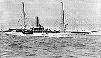
in the Monach Isles had a manned lighthouse until 1942. The tiny Beasts of Holm of the east coast of Lewis were the site of the sinking of the Iolaire
Iolaire
The Iolaire was an Admiralty yacht whose sinking on the 1 January 1919 in the Minch strait was one of the worst maritime disasters in United Kingdom waters during the 20th century...
during the first few hours of 1919, one of the worst maritime disasters in United Kingdom waters during the 20th century. Calvay
Calvay
Calvay , is an uninhabited island situated in the Sound of Eriskay in the Outer Hebrides.It was here that the ship SS Politician ran aground with a cargo of whisky in 1941 and inadvertently provided the inspiration for Compton MacKenzie's 1947 novel Whiskey Galore.-Other uses:A second island of the...
in the Sound of Barra provided the inspiration for Compton MacKenzie
Compton Mackenzie
Sir Compton Mackenzie, OBE was a writer and a Scottish nationalist.-Background:Compton Mackenzie was born in West Hartlepool, England, into a theatrical family of Mackenzies, but many of whose members used Compton as their stage surname, starting with his grandfather Henry Compton, a well-known...
's 1947 novel Whiskey Galore after the ran aground there with a cargo of whisky
Whisky
Whisky or whiskey is a type of distilled alcoholic beverage made from fermented grain mash. Different grains are used for different varieties, including barley, malted barley, rye, malted rye, wheat, and corn...
. Unusually for an uninhabited island, Eilean na Cille is connected to Grimsay (south)
Grimsay, South East Benbecula
Grimsay, south east of Benbecula is a tidal island of the Outer Hebrides. It is connected to Benbecula by a causeway which carries the B891. In the 2001 census, Grimsay had a population of 19....
by a causeway
Causeway
In modern usage, a causeway is a road or railway elevated, usually across a broad body of water or wetland.- Etymology :When first used, the word appeared in a form such as “causey way” making clear its derivation from the earlier form “causey”. This word seems to have come from the same source by...
.
Various Gaelic names are used repeatedly. The suffix ay or aigh or aidh is generally from the Norse øy meaning "island". Eilean (plural: eileanan) also means "island". Beag and mòr (also bheag and mhòr) mean "little" and "big" and are often found together. Sgeir is "skerry" and often refers to a rock or rocks that lie submerged at high tide. Dubh is "black", dearg is "red" and glas means "grey" or "green". Orasaigh
Oronsay
This is a list of islands called Oronsay , which provides an index for islands in Scotland with this and similar names. It is one of the more common names for Scottish islands. The names come from Örfirisey which translates from Old Norse as "tidal" or "ebb island"...
is from the Norse Örfirirsey meaning "tidal" or "ebb island".
Smaller islands grouped geographically:
Barra and the Barra Isles
- Barra: Eilean a' Mhail, Eilean Mhiathlais, Eileanan Dubha, Greanamul, Healam, Kisimul CastleKisimul CastleKisimul Castle is a small medieval castle located in the centre of Castlebay on Barra, an island of the Outer Hebrides, Scotland....
, Lamalum, Lingeigh-Fada, Orasaigh (2), Sgeir Mhòr, Sgeirislum - Barra Head: Rubha Niosaim and Sgeir Mhòr
- Flodday: None
- Lingeigh: None.
- Mingulay: Arnamuil, Barnacle Rock, Geirum Beag, Geirum Mòr, Gunamul. Lianamul, Sgeirean nan Uibhein, Solon Beag, Solon Mòr, Sròn à Dùin and The Red Boy.
- Muldoanich: An Laogh, Sgeirean Fiaclach.
- Pabbay: Greenamul, Heisgeir a-muigh, Heisgeir a-staigh, Lingeigh, Roisnis
- Sandray: Cleite, Creag an Sheadair, Eilean Mòr, Sgeir Lithinis
- Vatersay: BiruaslumBiruaslumBiruaslum or Bioruaslam is a stack in the Barra Isles of Scotland, to the west of Vatersay. Approximately from the nearest road, it reaches in height and there is a ruined prehistoric fort on the southern side. Francis G...
, Orasaigh, Sgeir Liath, Sgeir na Muice, Snuasamul, Uineasan
Sound of Barra
- Eriskay: CalbhaighCalvayCalvay , is an uninhabited island situated in the Sound of Eriskay in the Outer Hebrides.It was here that the ship SS Politician ran aground with a cargo of whisky in 1941 and inadvertently provided the inspiration for Compton MacKenzie's 1947 novel Whiskey Galore.-Other uses:A second island of the...
, Eilean à Gheoidh, Eileanan Dubha, Hearteamul, LingayLingay, FiarayLingay is an uninhabited Scottish island in the Sound of Barra in the Western Isles. It lies between South Uist, Eriskay, Fuday and Fiaray. Its maximum height is 51 metres.-Footnotes:...
, Na Stacan Dubha, Sgeir an Fheidh - Fiaraidh: Corran Bàn
- Flodday: Snagaras
- Fuday: Traillisgeir
- Fuiay: Eilean Sheumis, Garbh Lingeigh
- Gighay: Eilean à Ceud
- Hellisay: Bodha nan Sgeiran Mòra
- Orosay: None
South Uist
- West coast: Eilean Bheirean, Eilean Cuithe nam Fiadh, Gualan, Orasaigh
- North east coast: Dioraigh, Eilean à Mhadaidh, Eilean Ban, Eilean Ornais, Eilean na h-Airde Mhoire, Gasaigh, Glas-Eileanan, Luirsaigh Dubh, Luirsaigh Glas, Orasaigh, Sioloagh Mòr, Tathanais
- East coast: Calbhaigh (2), Dùn Othail, Eilean nan Ghamna
- Lochboisdale:
- Eileanan Iasgaich: Main group: Eilean Bàgh Mhic Rois, Eileanan Iasgaich Beag, Eileanan Iasgaich Meadhonach, Eileanan Iasgaich Mòr, Eilean nam Feannag. Surrounding: Eilean Mòr, Eilean nan Moireachean, Gasaigh, Pabaigh, Sgeir Chaise
- Stuley: Dubh-Sgeir Mhòr, Glas-Eilean Mòr
Benbecula
- North coast: Calabhagh, Eilean Leathann, Eilean Mhic Caoilte, Sunamul, Traillabreac Mòr
- East coast: Bearran, Collam, Eilean Baile Gearriadh, Eilean Dubh na Muice, Eilean nan Each, Fuidheigh Beag, Greanamul, Greanamul Deas, Maithidh Glas, Maithidh Riabhach, Maragaidh Beag, Maragaidh Mòr, Orasaigh (2), Orasaigh Uisgeabhagh
- South coast: Eilean Ard an Eoin, Heistamuil
- Fraoch-eilean: Eilean Roinoch, Mas Grimsay
- Flodaigh: Lingay and numerous others but none named by Ordnance Survey
- Grimsay (North): Eilean à Ghobha, Eilean Mòr
- Grimsay (South): Caraigh Mhòr, Eilean nan Cille, Eilean nan Gamhna, Eileanan Stafa, Fodragaigh, Oitir Bheag, Siusaigh, Steiseigh, Triallabreac
- Ronay: Eilean an Fheidh, Eilean na Clioche, Eilean nan h-Iolaire, Eilean nan Gamhna, Eilean nan Gearr, Garbh Eilean Mòr, Huanariagh
- Wiay: An Dubh-sgeir à Deas, Cleit Mhòr, Eileanan ChearabhaighEileanan ChearabhaighEileanan Chearabhaigh is a collection of small uninhabited tidal islands off the south east coast of Benbecula in the Outer Hebrides of Scotland. The English language name Keiravagh Islands is sometimes used....
, Lingeigh, Reagam, Scaracleit
North Uist

- North west coast: Eilean Mhorain, HaskeirHaskeirNot to be confused with Hyskeir or HeskeirHaskeir , also known as Great Haskeir is a remote, exposed and uninhabited island in the Outer Hebrides of Scotland. It lies west north west of North Uist. to the south west lie the skerries of Haskeir Eagach made up of a colonnade of five rock stacks...
, Hasgeir Eagach, Lingeigh- Traigh Bhalaigh: Eilean Dubh Mòr, Stangram, Torogaigh
- Sound of Harris, East:
- Loch Mhic Phail: Cafuam, Croabhagun, Eilean Fhionnlaidh, Frobost Island, Hestum, Mealla Bru, Rangas, Teilum
- West Coast: Causamul, Eilean Trostain
- East coast:
- Loch Euphort: Eilean an Stiobuill, Eilean Mhic Shealtair, Eilean nam Mult, Orasaigh, Riobhaig Mhòr, Steisaigh, Treanaigh
- Loch nam MadadhLochmaddyLochmaddy is the administrative centre of North Uist in the Outer Hebrides, Scotland...
: Cliasagh Beag, Cnap Ruigh Dubh, Eilean Bhalaig, Eilean Mhidhinis, Fathoire, Fearamas, Flodaigh, Hamarsaigh, Madadh Beag, Madadh Gruamach, Madadh Mòr, Olasaigh Mòr, Rhiobhagan Mhidhinis
- South Coast: Craigionn, Eilean an Teampaill, Eilean Iochdrach, Eilean Mòr
- Causeway: Eileanan Glasa, Eilean Ghiorr, Eilean Leathann, Eilean na h-Airigh, Gairbh-eilean
- Baleshare: Bhorogaigh, Eilean Mòr, Eilean nan Carnan, Glas-eilean Beag, Horaigh
- Ceallasaigh Mòr: Ceallasaigh Beag, Eilean nan Lion
- Flodaigh Mòr: Duibh-eilean, Flodaigh Beag
- Kirkibost: Bior Eilean, Eilean Mòr, Sromaigh
- Oronsay: Fuskafaol, Greanam, Lingay
- Vallay: Dun Tomaidh, Sgeir Dubh Mòr
Monach Isles
- Ceann Ear: Heilleam, StocaighStocaighStocaigh is one of the Monach Islands. It is a kilometre east of Coilleag Mhòr nan Dàmh in the far north east of Ceann Ear. On its east shore is the Camas Bàn, which is named for its white sand, which consists of finely ground sea shells-Footnotes:...
- Ceann Iar: Deasgair, Raisgeir, Stromay
- ShillayShillay, Monach IslandsShillay is the western-most of the Monach Islands , off North Uist in the Outer Hebrides.-Geology and geography:...
: Eilean Siorruidh, Thusigeirean
- Shillay
- Sibhinis: None
Sound of Harris
- Harris - Rubha Reinis to Gob an Tobha: Bumersam Beag, Copaigh, Craigo, Dun Arn, Eilean Reinis, Eire, Gilsaigh, Gousman, Grodhaigh, Gumersam Mhòr, Langaigh, Liungaigh, Saghaigh Beag, Saghaigh Mòr, SgarabhaighSgarabhaighSgarabhaigh is a small uninhabited island in the eastern end of the Sound of Harris, Outer Hebrides, Scotland.It is approximately in size and is home to many seabirds, otters and grey seals...
, Sgeir Sine, Sromaigh
- Berneray: Bhaiteam, Greineam, Torogaigh
- Boreray: Bogha Mairi, Spuir
- Ensay: Creag Ruadh, Dubh Sgeir, Sleicham, Sromaigh, Suam
- Hermetray: Bhacasaigh, Dun Mhic Leathann, Eileana Dubha, Fuam, Greineam, Grodaigh, Hulmatraigh, Orasaigh, Righe nam Ban
- Killegray: Caolaigh, Eilean Chodam, Eilean na Ceardaich, Langa Sgeir, Sgeir Dhubh, Sgeir Mhurain
- Pabbay: Cuidhnis
- Shillay: Siolaigh Beag
- Stromay: Heastam Sròmaigh, Rusgaigh, Orasaigh
- Tahay: Bhotarsaigh, Cleite nan Luch, Creag nan Sealladh, Fuam na h-Ola, Narstaigh, Opasaigh, Sarstaigh, Sgeir à Chuain, Sursaigh, Trollaman
West Harris
- Gob an Tobha to Rubha Huisinis: Gaisgeir, Glas-sgeir, Gloraig Huisinis, Gloraig Tharasaigh, Iosaigh
- Rubha Huisinis to Ceann Loch Resort: Greine Sgeir,
- Scarp: Cearstaigh, Duisgeir, Fladaigh
- Soay Mòr: Soay BeagSoay BeagSoay Beag is a small, uninhabited tidal island in West Loch Tarbert, between the northern and southern parts of Harris. Soay Beag is separated from the southwest coast of North Harris by the Soay Sound. The island is located immediately to the northwest of the larger Soay Mòr, which is accessible...
- Taransay: None
East Harris
- Loch SeaforthLoch SeaforthLoch Seaforth is sea loch in the Outer Hebrides of Scotland. It forms the boundary between Lewis and Harris and formerly was the boundary between the traditional counties of Ross and Cromarty and Inverness-shire....
: Eilean Mharaig, Glas Sgeir - Àrd Caol to Rubha Crago: Eilean Reiningeadil
- Rubha Crago to Rubha Bocaig (including East Loch TarbertEast Loch TarbertEast Loch Tarbert is a sea loch that lies to the east of the island of Harris in the Outer Hebrides of Scotland. The loch contains several small islands including Sgeotasaigh, Stiughiag, Stiughiag na Leum and Rosaigh and the larger bridged island of Scalpay...
): Cuidsgeir, Eilean à Gheoidh, Eileanan à Ghille-bheid, Eilean Aird Rainis, Eilean an Direcleit, Eilean Dubh, Eilean Mhic Fionnlaidh, Eilean na Gearrabreac, Eilean na Sgaite, Gloraig à Chaimbeulach, Gloraig Dubh, Gloraig Iosal, Sgeir an Leim Mhoir, Sgeir Glas, Sgeir Urgha - Rubha Bocaig to Rubha Reinis: (see also Stockinish Island): Bhalaigh, Caiream, Corr-eilean, Eilean Chuidhtinis, Eilean Dubh, Eilean Dubh Chollaim, Eilean Fhionnsbhaigh, Eilean Lingreabhaigh, Eilean Mhanais, Glas Sgeir (2)
- Scalpay: Fuam an Tolla, Greineam, Raiream, Rosaigh, Stiolamair, Stiughaigh, Stiughaigh na Leum, Thamarasaigh
- Sgeotasaigh: Eilean Dubh, Eilean Rainich, Sgeir Ghlas
- Stockinish: Eilean Leasait, Eilean nan Eun
Shiant Isles
- Eilean Mhuire: Seann Chaisteal
- Garbh Eilean: Sgeir Mianais
- The Galtachan: Bodach, Damhag, Galta Beag, Galta Mòr, Stacan Laidir, Sgeir Mhic a' Ghobha
Lewis
South west coast
Ceann Loch Resort to Aird Dhrolaige: Liongam, Staca Liath- Aird Dhrolaige to Camas Uig: Eilean Molach, Greineam, Sgeir an Tamna, Sgeir Liath, Staca Leathann
- Camas Uig: Fraoch Eilean, Leac Holm, Sarah's Island, Sgeir a' Chàis, Sgeir Liath, Sgeir Sheilibhig, Tom, Tolm
- Camas Uig to Gallan Head: Gallan Beg, Sgeir Fiabhaig Tarras, Sgeir Gallan
- Eilean Mhealasta: Hairsgeir Beag, Hairsgeir Mòr
Loch Ròg
- Loch Ròg:
- Loch Ceann Hulabhig: Eilean Trosdam, Eilean Orasaigh, Eilean an Tighe, Eimisgeir
- Loch Charlabhaigh: Eilean Bhinndealaim
- Loch Ròg Beag: Eilean Dubh, Eileanan Glasa
- Loch Shiadair: Crovag
- Ceabhaigh: Greinam, Sgeir nan Cliabh
- Eilean Chearstaidh: Bratanais Mòr, Eilean Sgarastaigh
- Flodaigh: Gousam
- Fuaigh Beag: Aird Orasaigh, Cliatasaigh, Eilean nam Feannag, Floday, Geile Sgeir, Garbh Eilean, Glas Eilean, Linngeam
- Fuaigh Mòr: EileanTeinis, Eunaigh Beag, Eunaigh Mòr, Geile Sgeir, Sgeir Dubh Mhòr, Sgeir Liath
- Great Bernera: Eilean Beag, Eilean Bhacasaigh, Eilean Mòr, Eilean Riosaigh, Eughlam, Greineam, Liongam Valasay
- Little Bernera: BearasaighBearasaighBearasaigh or Bearasay is an islet in outer Loch Ròg, Lewis, Scotland. During the late 16th and early 17th centuries it was used as a pirates' hideout and the remains of various buildings from that period still exist...
, CampaighCampaighCampaigh or Campay is a steep and rocky islet in outer Loch Ròg, Lewis, Scotland that lies north of Cealasaigh and Little Bernera.A huge natural arch transverses the northern half of the island from south west to north east and there is a large sea cave to the south...
, CealasaighCealasaighCealasaigh or Kealasay is an islet in outer Loch Ròg, Lewis, Scotland that lies north of Traigh Mhór on Little Bernera and south of Campaigh....
, Cruitear, Cul Campaigh, Eilean Fir Chrothair, FlodaighFlodaigh, Outer Loch RògFlodaigh is an islet in outer Loch Ròg, Lewis, Scotland. It lies north west of Great Bernera and Little Bernera, south of Bearasaigh and Seanna Chnoc and west of Campaigh....
, Hairsgeir, Mas Sgier, Seanna ChnocSeanna ChnocSeanna Chnoc is an islet in outer Loch Ròg, Lewis, Scotland. It lies north west of Great Bernera and Bearasaigh.Stac nam Balg lies offshore to the north and there is a cave in the north west of the island....
, Sgeir à Mhurain, Sgeir Dhearg, Sgeir na h-Aon Chaorocah. - Pabaigh Mòr: Bogha Dubh, Mas Sgeir, Pabeigh Beag, Siaram Mòr
- Vacsay: Sgeir Bocaig, Sgeir Fail, Sgeir na h-Aon Chaorach, Trathasam
North west coast
- Aird Laimisiadair to Butt of Lewis: Buistean, Cleite Gile, Cul Chraigeam, Craigeam, Dubh Sgeir, Eilean Arnol, Lith Sgeir, Mas Sgeir, Sgeir Dhail, Sgeir Dhearg Cul Chraigeam, Sgeir Lainganish, Sgeir Mhòr, Stac à Phris
East Coast
- Butt of LewisButt of LewisThe Butt of Lewis is the most northerly point of the Isle of Lewis in the Outer Hebrides. The headland, which lies in the North Atlantic, is frequently battered by heavy swells and storms.-Lighthouse:...
to Tolsta Head: Am Braga, Braighe Mhòr, Dùn ÈisteanDùn ÈisteanDùn Èistean is a multi-period archaeological site on an inter- tidal sea stack on the north east coast of the Isle of Lewis, near the village of Knockaird in the area of Nis in the Western Isles of Scotland. It is accorded the status of traditional stronghold of Clan Morrison - once a highly...
, Dun Eoradail, Eilean Glas, Mas Sgeir - Tolsta Head to Tiumpan Head: Heisgeir, Lada Sgeir, Langasgeir Mòr, Sgeir Leathann
- Tiumpan Head to Rubha Raerinis: Beasts of Holm, Buaile Mhòr, Eilean à Chaise, Eilean à Chrotaich, Eilean Beag Phabail, Eilean Mòr Phabail, Eilean na Greinne, Eilean Grioda, Eilean nan Uan, Eilean Thuilm, Mol Shildinis, Sgeir Mhòr Shildinis
- Rubha Raerinis to Rubha na Creige Moire (including Loch Erisort and Loch Liurbost): Bhatarsaidh, Dun Bharclin, Eilean à Bhlair, Eilean Cheois, Eilean Glas, Eilean Miabhiag, Eilean Mòr Lacasaidh, Eilean Mhic Thormaid, Eilean Orasaigh (2), Eilean Rosaidh, Eilean Thoraidh, Garbh Eilean, Glas Sgeir, Riosaigh, Seumas Cleite, Sgeiran Arbhair, Sgeir Tanais, Stac Tabhaidh, Tabhaigh Beah, Tabhaigh Mòr, Tannaraidh
- Rubha na Creige Moire to Gob Rubha Uisnis (including Loch Sealg): Bogha Ruadh
- Gob Rubha Uisnis to Rubha Brìodog: Eilean Beag à Bhaigh, Eilean Dubh à Bhaigh, Eilean Glas na h-Acarsaid Fhalaich, Eilean Mòr à Bhaigh, Eilean Thinngartsaigh, Sgeir Mhòr Bhalamuis
- Eilean Chaluim Chille: Eilean Calabraigh, Crois Eilean, Duine, Eilean a Bhlair, Riasiagh, Sgeir nan Muirsgian, Sgeir nan Each
- Eilean Liubhaird: Sgeir Fhraoich, Sgeir nan Caorach, Stac à Bhaigh
- Seaforth Island: None
Small archipelagos
The St Kilda group is 64 kilometres (39.8 mi) west-northwest of North Uist.