

Clackamas County, Oregon
Encyclopedia
Clackamas County is a county located in the U.S. state
of Oregon
. The county was named
after the Native Americans
living in the area, the Clackamas Indians
, who were part of the Chinookan
people. As of 2010, the population was 375,992. Its county seat
is Oregon City
.
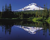
, the only year-round ski resort
in the United States and the site of Timberline Lodge, is a major attraction for recreation and tourism. The mountain and its rivers and forests offer outdoor recreation activities, from skiing
and rafting
to fishing
and camping
.
, the county has a total area of 1879 square miles (4,866.6 km²). 1868 square miles (4,838.1 km²) is land and 11 square miles (28.5 km²), (0.58%) is water.
The county includes parts of two national forests: Mount Hood National Forest
and Willamette National Forest
.
of 2000, there were 338,391 people, 128,201 households, and 91,663 families residing in the county. The population density
was 181 people per square mile (70/km²). There were 136,954 housing units at an average density of 73 per square mile (28/km²). The racial makeup of the county was 91.27% White
, 2.45% Asian
, 0.71% Native American
, 0.66% Black
or African American
, 0.17% Pacific Islander
, 2.28% from other races
, and 2.46% from two or more races. 4.95% of the population were Hispanic
or Latino
of any race. 20.7% were of German, 11.6% English
, 9.1% Irish
and 7.5% American
ancestry.
There were 128,201 households out of which 34.20% had children under the age of 18 living with them, 58.60% were married couples
living together, 9.00% had a female householder with no husband present, and 28.50% were non-families. 22.00% of all households were made up of individuals and 7.80% had someone living alone who was 65 years of age or older. The average household size was 2.62 and the average family size was 3.07.
In the county, the population was spread out with 26.20% under the age of 18, 8.00% from 18 to 24, 28.70% from 25 to 44, 26.00% from 45 to 64, and 11.10% who were 65 years of age or older. The median age was 38 years. For every 100 females there were 97.50 males. For every 100 females age 18 and over, there were 94.90 males.
The median income for a household in the county was $52,080, and the median income for a family was $60,791. Males had a median income of $43,462 versus $30,891 for females. The per capita income
for the county was $25,973. About 4.60% of families and 6.60% of the population were below the poverty line, including 7.60% of those under age 18 and 5.10% of those age 65 or over.
), Champooick (later Marion
), and Yamhill
. The four districts were redesignated as counties in 1845. At the time of its creation, Clackamas County covered portions of four present-day states and a Canadian province. The Columbia River
became the northern boundary of the county in 1844. Soon after John McLoughlin
staked a land claim in Oregon City and built a house that in 2003 became a unit of the Fort Vancouver National Historic Site
.
Oregon City was also the site of the only federal court west of the Rockies in 1849, when San Francisco, California
was platted. The plat
was filed in 1850 in the first plat book of the first office of records in the West Coast and is still in Oregon City.
In 1902, the Willamette Meteorite
was recovered from a field just outside present-day West Linn
.
In contrast with the more liberal and cosmopolitan Multnomah County
to the north, and the more corporate Washington County
to the west, some citizens of Clackamas county have espoused a blue-collar, yet conservative political outlook of the backlash mold described by Thomas Frank
. It is the headquarters of Lon Mabon, whose Oregon Citizens Alliance
has worked to pass a number of anti-homosexual initiatives, and where Bill Sizemore
, who has championed various anti-government initiatives for most of the 1990s, had his base before he moved to Klamath Falls. However, it is a very mixed area overall, narrowly voting for Republican
George W. Bush
over Democrat
John Kerry
in 2004, but moderately voting for Democrat
Barack Obama
over Republican
John McCain
in 2008.
, Clackamas is the first county in Oregon to have four models of governance for its communities. Like the rest of Oregon, it has cities (which are formally incorporated) and rural communities (some of which for federal purposes are considered census-designated place
s).
After completion of a process that began late in 1999, the county adopted an ordinance
on August 11, 2005 which defined hamlets
and villages
. As of the November 30, 2005, deadline, three communities have submitted petitions to start the process of becoming a hamlet or a village. Boring
petitioned to become a village. The communities along US 26 near Mount Hood from Brightwood
to Rhododendron
have petitioned to become "The Villages at Mount Hood". Beavercreek
has become a hamlet.
Elected Officials
 Several of the county's communities extend into other counties. Lake Oswego
and Milwaukie
include areas in Multnomah County
. Lake Oswego
, Tualatin
, Rivergrove
and Wilsonville
include areas in Washington County
.
is a model of local governance for unincorporated areas.
.
The urban areas of the county are also served by Metro
.
U.S. state
A U.S. state is any one of the 50 federated states of the United States of America that share sovereignty with the federal government. Because of this shared sovereignty, an American is a citizen both of the federal entity and of his or her state of domicile. Four states use the official title of...
of Oregon
Oregon
Oregon is a state in the Pacific Northwest region of the United States. It is located on the Pacific coast, with Washington to the north, California to the south, Nevada on the southeast and Idaho to the east. The Columbia and Snake rivers delineate much of Oregon's northern and eastern...
. The county was named
Oregon Geographic Names
Oregon Geographic Names is an authoritative compilation of the origin and meaning of place names in the U.S. state of Oregon. , the book is in its seventh edition and is compiled and edited by Lewis L. McArthur, who took over from his father, Lewis A. McArthur, as of the fourth edition...
after the Native Americans
Native Americans in the United States
Native Americans in the United States are the indigenous peoples in North America within the boundaries of the present-day continental United States, parts of Alaska, and the island state of Hawaii. They are composed of numerous, distinct tribes, states, and ethnic groups, many of which survive as...
living in the area, the Clackamas Indians
Clackamas Indians
The Clackamas Indians are a tribe of Native Americans of the U.S. state of Oregon who traditionally lived along the Clackamas River in the Willamette Valley. Lewis and Clark estimated their population at 1800 in 1806...
, who were part of the Chinookan
Chinookan
Chinook refers to several native amercain groups of in the Pacific Northwest region of the United States, speaking the Chinookan languages. In the early 19th century, the Chinookan-speaking peoples lived along the lower and middle Columbia River in present-day Oregon and Washington...
people. As of 2010, the population was 375,992. Its county seat
County seat
A county seat is an administrative center, or seat of government, for a county or civil parish. The term is primarily used in the United States....
is Oregon City
Oregon City, Oregon
Oregon City was the first city in the United States west of the Rocky Mountains to be incorporated. It is the county seat of Clackamas County, Oregon...
.
Economy
Since the county's creation, agriculture, timber, manufacturing, and commerce have been the principal economic activities. Mount HoodMount Hood
Mount Hood, called Wy'east by the Multnomah tribe, is a stratovolcano in the Cascade Volcanic Arc of northern Oregon. It was formed by a subduction zone and rests in the Pacific Northwest region of the United States...
, the only year-round ski resort
Ski resort
A ski resort is a resort developed for skiing and other winter sports. In Europe a ski resort is a town or village in a ski area - a mountainous area, where there are ski trails and supporting services such as hotels and other accommodation, restaurants, equipment rental and a ski lift system...
in the United States and the site of Timberline Lodge, is a major attraction for recreation and tourism. The mountain and its rivers and forests offer outdoor recreation activities, from skiing
Skiing
Skiing is a recreational activity using skis as equipment for traveling over snow. Skis are used in conjunction with boots that connect to the ski with use of a binding....
and rafting
Rafting
Rafting or white water rafting is a challenging recreational outdoor activity using an inflatable raft to navigate a river or other bodies of water. This is usually done on white water or different degrees of rough water, in order to thrill and excite the raft passengers. The development of this...
to fishing
Fishing
Fishing is the activity of trying to catch wild fish. Fish are normally caught in the wild. Techniques for catching fish include hand gathering, spearing, netting, angling and trapping....
and camping
Camping
Camping is an outdoor recreational activity. The participants leave urban areas, their home region, or civilization and enjoy nature while spending one or several nights outdoors, usually at a campsite. Camping may involve the use of a tent, caravan, motorhome, cabin, a primitive structure, or no...
.
Geography
According to the U.S. Census BureauUnited States Census Bureau
The United States Census Bureau is the government agency that is responsible for the United States Census. It also gathers other national demographic and economic data...
, the county has a total area of 1879 square miles (4,866.6 km²). 1868 square miles (4,838.1 km²) is land and 11 square miles (28.5 km²), (0.58%) is water.
The county includes parts of two national forests: Mount Hood National Forest
Mount Hood National Forest
The Mount Hood National Forest is located east of the city of Portland, Oregon, and the northern Willamette River valley. The Forest extends south from the Columbia River Gorge across more than of forested mountains, lakes and streams to the Olallie Scenic Area, a high lake basin under the slopes...
and Willamette National Forest
Willamette National Forest
The Willamette National Forest is a National Forest located in the central portion of the Cascade Range of US state of Oregon.It comprises 1,675,407 acres making it one of the largest national forests. Over 380,000 acres are designated wilderness which include seven major mountain peaks...
.
Major highways
 Interstate 5Interstate 5 in OregonIn the U.S. state of Oregon, Interstate 5 traverses the state from north to south, passing through the major cities of Portland, Salem, Eugene, and Medford.-Route description:...
 Interstate 205Interstate 205 (Oregon-Washington)Interstate 205 is a loop route that serves the Portland—Vancouver metropolitan area in the U.S. states of Oregon and Washington. I-205 is officially named the War Veterans Memorial Freeway, and is also known as the East Portland Freeway...
 U.S. Route 26U.S. Route 26 in OregonIn the U.S. state of Oregon, U.S. Route 26 is a major cross-state state highway, connecting U.S. Route 101 on the Oregon Coast near Seaside with the Idaho state line east of Nyssa. Local highway names include the Sunset Highway No. 47, Mount Hood Highway No. 26, and John Day Highway No...
 Oregon Route 35
 Oregon Route 99E
 Oregon Route 212
 Oregon Route 213
 Oregon Route 224
Adjacent counties
- Multnomah CountyMultnomah County, OregonMultnomah County is one of 36 counties in the U.S. state of Oregon. Though smallest in area, it is the most populous as its county seat, Portland, is the state's largest city...
- north - Hood River CountyHood River County, Oregon-Demographics:As of the census of 2000, there were 20,411 people, 7,248 households, and 5,175 families residing in the county. The population density was 39 people per square mile . There were 7,818 housing units at an average density of 15 per square mile...
- northeast - Wasco CountyWasco County, OregonWasco County is a county located in the U.S. state of Oregon. The county is named for a local tribe of Native Americans, the Wasco, a Chinook tribe who lived on the south side of the Columbia River. In 2010, its population was 25,213...
- east - Marion CountyMarion County, OregonMarion County is a county located in the U.S. state of Oregon. It was originally named the Champooick District, after Champoeg, a meeting place on the Willamette River. On September 3, 1849, the territorial legislature renamed it in honor of Francis Marion, a Continental Army general of the...
- south - Yamhill CountyYamhill County, Oregon-National protected areas:*Siuslaw National Forest *Tualatin River National Wildlife Refuge -Demographics:As of the census of 2000, there were 84,992 people, 28,732 households, and 21,376 families residing in the county. The population density was 119 people per square mile . There were 30,270...
- west - Washington CountyWashington County, Oregon- Major highways :* Interstate 5* Interstate 205* U.S. Route 26* Oregon Route 6* Oregon Route 8* Oregon Route 10* Oregon Route 47* Oregon Route 99W* Oregon Route 210* Oregon Route 217* Oregon Route 219-Demographics:...
- northwest
Demographics
As of the censusCensus
A census is the procedure of systematically acquiring and recording information about the members of a given population. It is a regularly occurring and official count of a particular population. The term is used mostly in connection with national population and housing censuses; other common...
of 2000, there were 338,391 people, 128,201 households, and 91,663 families residing in the county. The population density
Population density
Population density is a measurement of population per unit area or unit volume. It is frequently applied to living organisms, and particularly to humans...
was 181 people per square mile (70/km²). There were 136,954 housing units at an average density of 73 per square mile (28/km²). The racial makeup of the county was 91.27% White
Race (United States Census)
Race and ethnicity in the United States Census, as defined by the Federal Office of Management and Budget and the United States Census Bureau, are self-identification data items in which residents choose the race or races with which they most closely identify, and indicate whether or not they are...
, 2.45% Asian
Race (United States Census)
Race and ethnicity in the United States Census, as defined by the Federal Office of Management and Budget and the United States Census Bureau, are self-identification data items in which residents choose the race or races with which they most closely identify, and indicate whether or not they are...
, 0.71% Native American
Race (United States Census)
Race and ethnicity in the United States Census, as defined by the Federal Office of Management and Budget and the United States Census Bureau, are self-identification data items in which residents choose the race or races with which they most closely identify, and indicate whether or not they are...
, 0.66% Black
Race (United States Census)
Race and ethnicity in the United States Census, as defined by the Federal Office of Management and Budget and the United States Census Bureau, are self-identification data items in which residents choose the race or races with which they most closely identify, and indicate whether or not they are...
or African American
Race (United States Census)
Race and ethnicity in the United States Census, as defined by the Federal Office of Management and Budget and the United States Census Bureau, are self-identification data items in which residents choose the race or races with which they most closely identify, and indicate whether or not they are...
, 0.17% Pacific Islander
Race (United States Census)
Race and ethnicity in the United States Census, as defined by the Federal Office of Management and Budget and the United States Census Bureau, are self-identification data items in which residents choose the race or races with which they most closely identify, and indicate whether or not they are...
, 2.28% from other races
Race (United States Census)
Race and ethnicity in the United States Census, as defined by the Federal Office of Management and Budget and the United States Census Bureau, are self-identification data items in which residents choose the race or races with which they most closely identify, and indicate whether or not they are...
, and 2.46% from two or more races. 4.95% of the population were Hispanic
Race (United States Census)
Race and ethnicity in the United States Census, as defined by the Federal Office of Management and Budget and the United States Census Bureau, are self-identification data items in which residents choose the race or races with which they most closely identify, and indicate whether or not they are...
or Latino
Race (United States Census)
Race and ethnicity in the United States Census, as defined by the Federal Office of Management and Budget and the United States Census Bureau, are self-identification data items in which residents choose the race or races with which they most closely identify, and indicate whether or not they are...
of any race. 20.7% were of German, 11.6% English
English people
The English are a nation and ethnic group native to England, who speak English. The English identity is of early mediaeval origin, when they were known in Old English as the Anglecynn. England is now a country of the United Kingdom, and the majority of English people in England are British Citizens...
, 9.1% Irish
Irish people
The Irish people are an ethnic group who originate in Ireland, an island in northwestern Europe. Ireland has been populated for around 9,000 years , with the Irish people's earliest ancestors recorded having legends of being descended from groups such as the Nemedians, Fomorians, Fir Bolg, Tuatha...
and 7.5% American
United States
The United States of America is a federal constitutional republic comprising fifty states and a federal district...
ancestry.
There were 128,201 households out of which 34.20% had children under the age of 18 living with them, 58.60% were married couples
Marriage
Marriage is a social union or legal contract between people that creates kinship. It is an institution in which interpersonal relationships, usually intimate and sexual, are acknowledged in a variety of ways, depending on the culture or subculture in which it is found...
living together, 9.00% had a female householder with no husband present, and 28.50% were non-families. 22.00% of all households were made up of individuals and 7.80% had someone living alone who was 65 years of age or older. The average household size was 2.62 and the average family size was 3.07.
In the county, the population was spread out with 26.20% under the age of 18, 8.00% from 18 to 24, 28.70% from 25 to 44, 26.00% from 45 to 64, and 11.10% who were 65 years of age or older. The median age was 38 years. For every 100 females there were 97.50 males. For every 100 females age 18 and over, there were 94.90 males.
The median income for a household in the county was $52,080, and the median income for a family was $60,791. Males had a median income of $43,462 versus $30,891 for females. The per capita income
Per capita income
Per capita income or income per person is a measure of mean income within an economic aggregate, such as a country or city. It is calculated by taking a measure of all sources of income in the aggregate and dividing it by the total population...
for the county was $25,973. About 4.60% of families and 6.60% of the population were below the poverty line, including 7.60% of those under age 18 and 5.10% of those age 65 or over.
History
Originally named Clackamas District, it was one of the four original Oregon districts created by Oregon's Provisional Legislature on July 5, 1843 along with Twality (later WashingtonWashington County, Oregon
- Major highways :* Interstate 5* Interstate 205* U.S. Route 26* Oregon Route 6* Oregon Route 8* Oregon Route 10* Oregon Route 47* Oregon Route 99W* Oregon Route 210* Oregon Route 217* Oregon Route 219-Demographics:...
), Champooick (later Marion
Marion County, Oregon
Marion County is a county located in the U.S. state of Oregon. It was originally named the Champooick District, after Champoeg, a meeting place on the Willamette River. On September 3, 1849, the territorial legislature renamed it in honor of Francis Marion, a Continental Army general of the...
), and Yamhill
Yamhill County, Oregon
-National protected areas:*Siuslaw National Forest *Tualatin River National Wildlife Refuge -Demographics:As of the census of 2000, there were 84,992 people, 28,732 households, and 21,376 families residing in the county. The population density was 119 people per square mile . There were 30,270...
. The four districts were redesignated as counties in 1845. At the time of its creation, Clackamas County covered portions of four present-day states and a Canadian province. The Columbia River
Columbia River
The Columbia River is the largest river in the Pacific Northwest region of North America. The river rises in the Rocky Mountains of British Columbia, Canada, flows northwest and then south into the U.S. state of Washington, then turns west to form most of the border between Washington and the state...
became the northern boundary of the county in 1844. Soon after John McLoughlin
John McLoughlin
Dr. John McLoughlin, baptized Jean-Baptiste McLoughlin, was the Chief Factor of the Columbia Fur District of the Hudson's Bay Company at Fort Vancouver. He was later known as the "Father of Oregon" for his role in assisting the American cause in the Oregon Country in the Pacific Northwest...
staked a land claim in Oregon City and built a house that in 2003 became a unit of the Fort Vancouver National Historic Site
Fort Vancouver National Historic Site
Fort Vancouver National Historic Site is a United States National Historic Site located in the states of Washington and Oregon. The National Historic Site consists of two units, one located on the site of Fort Vancouver in modern-day Vancouver, Washington; the other being the former residence of...
.
Oregon City was also the site of the only federal court west of the Rockies in 1849, when San Francisco, California
San Francisco, California
San Francisco , officially the City and County of San Francisco, is the financial, cultural, and transportation center of the San Francisco Bay Area, a region of 7.15 million people which includes San Jose and Oakland...
was platted. The plat
Plat
A plat in the U.S. is a map, drawn to scale, showing the divisions of a piece of land. Other English-speaking countries generally call such documents a cadastral map or plan....
was filed in 1850 in the first plat book of the first office of records in the West Coast and is still in Oregon City.
In 1902, the Willamette Meteorite
Willamette Meteorite
The Willamette Meteorite, officially named Willamette, is an iron-nickel meteorite discovered in the U.S. state of Oregon. It is the largest meteorite found in North America and the sixth largest in the world...
was recovered from a field just outside present-day West Linn
West Linn, Oregon
West Linn is a city in Clackamas County, Oregon, United States. Now a prosperous southern suburb of Portland, West Linn has a history of early development, prompted by the opportunity to harvest energy from nearby Willamette Falls. It was named after Senator Dr. Lewis Fields Linn of Ste...
.
In contrast with the more liberal and cosmopolitan Multnomah County
Multnomah County, Oregon
Multnomah County is one of 36 counties in the U.S. state of Oregon. Though smallest in area, it is the most populous as its county seat, Portland, is the state's largest city...
to the north, and the more corporate Washington County
Washington County, Oregon
- Major highways :* Interstate 5* Interstate 205* U.S. Route 26* Oregon Route 6* Oregon Route 8* Oregon Route 10* Oregon Route 47* Oregon Route 99W* Oregon Route 210* Oregon Route 217* Oregon Route 219-Demographics:...
to the west, some citizens of Clackamas county have espoused a blue-collar, yet conservative political outlook of the backlash mold described by Thomas Frank
Thomas Frank
Thomas Frank is an American author, journalist and columnist for Harper's Magazine. He is a former columnist for the Wall Street Journal, authoring "The Tilting Yard" from 2008 to 2010....
. It is the headquarters of Lon Mabon, whose Oregon Citizens Alliance
Oregon Citizens Alliance
The Oregon Citizens Alliance was a conservative Christian political activist organization, founded by Lon Mabon in the U.S. state of Oregon. It was founded in 1986 as a vehicle to challenge then–U.S...
has worked to pass a number of anti-homosexual initiatives, and where Bill Sizemore
Bill Sizemore
Bill Sizemore is a political activist in Redmond, Oregon, United States. Sizemore has never held elected office, but has nonetheless been a major political figure in Oregon since the 1990s. He is considered one of the main proponents of the Oregon tax revolt, a movement that seeks to reduce taxes...
, who has championed various anti-government initiatives for most of the 1990s, had his base before he moved to Klamath Falls. However, it is a very mixed area overall, narrowly voting for Republican
Republican Party (United States)
The Republican Party is one of the two major contemporary political parties in the United States, along with the Democratic Party. Founded by anti-slavery expansion activists in 1854, it is often called the GOP . The party's platform generally reflects American conservatism in the U.S...
George W. Bush
George W. Bush
George Walker Bush is an American politician who served as the 43rd President of the United States, from 2001 to 2009. Before that, he was the 46th Governor of Texas, having served from 1995 to 2000....
over Democrat
Democratic Party (United States)
The Democratic Party is one of two major contemporary political parties in the United States, along with the Republican Party. The party's socially liberal and progressive platform is largely considered center-left in the U.S. political spectrum. The party has the lengthiest record of continuous...
John Kerry
John Kerry
John Forbes Kerry is the senior United States Senator from Massachusetts, the 10th most senior U.S. Senator and chairman of the Senate Foreign Relations Committee. He was the presidential nominee of the Democratic Party in the 2004 presidential election, but lost to former President George W...
in 2004, but moderately voting for Democrat
Democratic Party (United States)
The Democratic Party is one of two major contemporary political parties in the United States, along with the Republican Party. The party's socially liberal and progressive platform is largely considered center-left in the U.S. political spectrum. The party has the lengthiest record of continuous...
Barack Obama
Barack Obama
Barack Hussein Obama II is the 44th and current President of the United States. He is the first African American to hold the office. Obama previously served as a United States Senator from Illinois, from January 2005 until he resigned following his victory in the 2008 presidential election.Born in...
over Republican
Republican Party (United States)
The Republican Party is one of the two major contemporary political parties in the United States, along with the Democratic Party. Founded by anti-slavery expansion activists in 1854, it is often called the GOP . The party's platform generally reflects American conservatism in the U.S...
John McCain
John McCain
John Sidney McCain III is the senior United States Senator from Arizona. He was the Republican nominee for president in the 2008 United States election....
in 2008.
, Clackamas is the first county in Oregon to have four models of governance for its communities. Like the rest of Oregon, it has cities (which are formally incorporated) and rural communities (some of which for federal purposes are considered census-designated place
Census-designated place
A census-designated place is a concentration of population identified by the United States Census Bureau for statistical purposes. CDPs are delineated for each decennial census as the statistical counterparts of incorporated places such as cities, towns and villages...
s).
After completion of a process that began late in 1999, the county adopted an ordinance
Law
Law is a system of rules and guidelines which are enforced through social institutions to govern behavior, wherever possible. It shapes politics, economics and society in numerous ways and serves as a social mediator of relations between people. Contract law regulates everything from buying a bus...
on August 11, 2005 which defined hamlets
Hamlet (Oregon)
A hamlet is a model of local governance in Clackamas County in the U.S. state of Oregon. Like hamlets elsewhere, it is a country subdivision; like New York's hamlets, the definition is unique to a state ....
and villages
Village (Oregon)
A village in the U.S. state of Oregon is a model of local governance that only exists in Clackamas County. Like villages elsewhere, it is a subnational entity; like New York's villages, the definition is unique to a state .Villages in Oregon are in addition to hamlets in Oregon and to Community...
. As of the November 30, 2005, deadline, three communities have submitted petitions to start the process of becoming a hamlet or a village. Boring
Boring, Oregon
Boring is an unincorporated community located in Clackamas County, Oregon, United States, on Oregon Route 212. It is approximately eight miles south of Gresham and about the same distance from Clackamas, both suburbs of Portland. The town is roughly twenty-two miles southeast from downtown...
petitioned to become a village. The communities along US 26 near Mount Hood from Brightwood
Brightwood, Oregon
Brightwood is an unincorporated community within the Mount Hood Corridor in Clackamas County, Oregon, United States. It is located between Wemme and Sandy just off of U.S. Route 26 at an elevation of 355 meters. It is one of the communities that make up the Villages at Mount Hood.A post office...
to Rhododendron
Rhododendron, Oregon
Rhododendron is an unincorporated community in Clackamas County, Oregon, United States. It is located within the Mount Hood Corridor, between Government Camp and Zigzag on U.S. Route 26...
have petitioned to become "The Villages at Mount Hood". Beavercreek
Beavercreek, Oregon
Beavercreek is a hamlet in Clackamas County, Oregon, United States, located four miles southeast of Oregon City. The population was 4,485 at the 2010 census.-History:...
has become a hamlet.
Law and government
| Year | Republican Republican Party (United States) The Republican Party is one of the two major contemporary political parties in the United States, along with the Democratic Party. Founded by anti-slavery expansion activists in 1854, it is often called the GOP . The party's platform generally reflects American conservatism in the U.S... |
Democratic Democratic Party (United States) The Democratic Party is one of two major contemporary political parties in the United States, along with the Republican Party. The party's socially liberal and progressive platform is largely considered center-left in the U.S. political spectrum. The party has the lengthiest record of continuous... |
|---|---|---|
| 2008 | 43.6% 83,595 | 54.0% 103,476 |
| 2004 | 50.1% 97,691 | 48.8% 95,129 |
| 2000 | 47.8% 77,539 | 47.1% 76,421 |
| 1996 | 41.0% 59,443 | 46.6% 67,709 |
| 1992 | 34.8% 53,724 | 39.0% 60,310 |
Elected Officials
- Board of County Commissioners (one chair, four commissioners; nonpartisan)
- Chair: Lynn Peterson
- Commissioner: Paul Savas
- Commissioner: Jim Bernard
- Commissioner: Charlotte Lehan
- Commissioner: Ann Lininger
- Treasurer: Shari Anderson
- Assessor: Bob Vroman
- District Attorney: John Foote
- County Clerk: Sherry Hall
- SheriffClackamas County Sheriff's OfficeThe Clackamas County Sheriff's Office is the law enforcement agency led by the elected sheriff of Clackamas County, Oregon. It provides police services to unincorporated portions of Clackamas County and contracts police services to the incorporated cities of Wilsonville, Estacada, Happy Valley,...
: Craig Roberts - Justice Court Judge: Karen Brisbin
Cities and communities
Lake Oswego, Oregon
Lake Oswego is a city located primarily in Clackamas County in the U.S. state of Oregon. Small portions of the city are also located in neighboring Multnomah and Washington counties. Located south of Portland surrounding the Oswego Lake, the town was founded in 1847 and incorporated as Oswego in...
and Milwaukie
Milwaukie, Oregon
Milwaukie is a city in Clackamas County, Oregon, United States. A very small portion of the city extends into Multnomah County. The population was 20,291 at the 2010 census. Founded in 1848 on the banks of the Willamette River, the city, known as the Dogwood City of the West, was incorporated in...
include areas in Multnomah County
Multnomah County, Oregon
Multnomah County is one of 36 counties in the U.S. state of Oregon. Though smallest in area, it is the most populous as its county seat, Portland, is the state's largest city...
. Lake Oswego
Lake Oswego, Oregon
Lake Oswego is a city located primarily in Clackamas County in the U.S. state of Oregon. Small portions of the city are also located in neighboring Multnomah and Washington counties. Located south of Portland surrounding the Oswego Lake, the town was founded in 1847 and incorporated as Oswego in...
, Tualatin
Tualatin, Oregon
Tualatin is a city located primarily in Washington County in the U.S. state of Oregon. A small portion of the city is also located in neighboring Clackamas County. It is a southwestern suburb in the Portland Metropolitan Area that is located south of Tigard...
, Rivergrove
Rivergrove, Oregon
Rivergrove is a city in Clackamas, Oregon, United States. A small portion of the city extends into Washington County. Its name comes from a combination of the Tualatin River, which forms its southern border, and Lake Grove, a community that is now part of Lake Oswego...
and Wilsonville
Wilsonville, Oregon
Wilsonville is a city primarily in Clackamas County, Oregon, United States. A portion of the northern section of the city is in Washington County. Originally founded as Boones Landing due to the Boones Ferry which crossed the Willamette River at the location, the community became Wilsonville in...
include areas in Washington County
Washington County, Oregon
- Major highways :* Interstate 5* Interstate 205* U.S. Route 26* Oregon Route 6* Oregon Route 8* Oregon Route 10* Oregon Route 47* Oregon Route 99W* Oregon Route 210* Oregon Route 217* Oregon Route 219-Demographics:...
.
Cities and CDPs in the Portland metropolitan area
|
Oak Grove, Oregon Oak Grove is an unincorporated community in Clackamas County, Oregon, United States. For statistical purposes, the United States Census Bureau has defined Oak Grove as a census-designated place . The census definition of the area may not precisely correspond to local understanding of the area with... (a CDP) Oatfield, Oregon Oatfield is a census-designated place in Clackamas County, Oregon, United States. It is in the Portland metropolitan area. As of the 2000 census, the population of the CDP was 15,750.It is named after Oatfield Road, which runs between Milwaukie and Gladstone... (a CDP) Oregon City, Oregon Oregon City was the first city in the United States west of the Rocky Mountains to be incorporated. It is the county seat of Clackamas County, Oregon... Rivergrove, Oregon Rivergrove is a city in Clackamas, Oregon, United States. A small portion of the city extends into Washington County. Its name comes from a combination of the Tualatin River, which forms its southern border, and Lake Grove, a community that is now part of Lake Oswego... Tualatin, Oregon Tualatin is a city located primarily in Washington County in the U.S. state of Oregon. A small portion of the city is also located in neighboring Clackamas County. It is a southwestern suburb in the Portland Metropolitan Area that is located south of Tigard... (a small portion) West Linn, Oregon West Linn is a city in Clackamas County, Oregon, United States. Now a prosperous southern suburb of Portland, West Linn has a history of early development, prompted by the opportunity to harvest energy from nearby Willamette Falls. It was named after Senator Dr. Lewis Fields Linn of Ste... Wilsonville, Oregon Wilsonville is a city primarily in Clackamas County, Oregon, United States. A portion of the northern section of the city is in Washington County. Originally founded as Boones Landing due to the Boones Ferry which crossed the Willamette River at the location, the community became Wilsonville in... |
Other incorporated cities and CDPs
|
Molalla, Oregon Molalla is a city in Clackamas County, Oregon, United States. The population was 5,647 at the 2000 census.-History:Molalla was named after the Molalla River, which in turn was named for the Molala, a Native American tribe that inhabited the area. William H. Vaughan took up a donation land claim in... Mount Hood Village, Oregon Mount Hood Village is the name of a census-designated place within the Mount Hood Corridor in Clackamas County, Oregon, United States. As of the 2000 census, the CDP had a total population of 3,306... (a CDP) Sandy, Oregon Sandy is a city located in Clackamas County, Oregon, United States, and named after the nearby Sandy River. As of the 2000 census, the city had a total population of 5,385, however the 2006 estimate shows 7,070 people.... |
Other unincorporated communities
- Aims
- Alder Creek
- BartonBarton, OregonBarton is an unincorporated community in Clackamas County, Oregon, United States, on Oregon Route 224 near the Clackamas River.Barton was named after Barton, Wisconsin by settler E. H. Burghardt. Burghardt started a flour mill and store near the mouth of Deep Creek, and later was postmaster of the...
- BoringBoring, OregonBoring is an unincorporated community located in Clackamas County, Oregon, United States, on Oregon Route 212. It is approximately eight miles south of Gresham and about the same distance from Clackamas, both suburbs of Portland. The town is roughly twenty-two miles southeast from downtown...
- Bull RunBull Run, OregonBull Run is an unincorporated community in Clackamas County, Oregon, United States, about northeast of Sandy near the Bull Run River.The first post office in the locale was "Unavilla", established in 1893. The name was changed to "Bullrun" in 1895, and to Camp Namanu in 1939. The post office was...
- CanemahCanemah, OregonCanemah was an early settlement in the U.S. state of Oregon located near Willamette Falls on the Willamette River. It is now a district within Oregon City.-Location:...
- CarusCarus, OregonCarus is an unincorporated community in Clackamas County, Oregon, United States. It is located about seven miles south of Oregon City, on Oregon Route 213....
- CharbonneauCharbonneau, OregonCharbonneau is a private planned community within the city limits of Wilsonville in Clackamas County, Oregon, United States...
(private community within
the city limits of Wilsonville) - CherryvilleCherryville, OregonCherryville is an unincorporated community in Clackamas County, Oregon, United States. It is about six miles east of Sandy on U.S. Route 26, near the route of the Barlow Road....
- Clarkes
- ColtonColton, OregonColton is an unincorporated community located in Clackamas County, Oregon, United States, on Oregon Route 211. Colton is located between the cities of Estacada and Molalla....
- CottrellCottrell, OregonCottrell is an unincorporated crossroads community in north Clackamas County, Oregon, United States. It was named for the family of Mrs. Charles Andrews, whose maiden name was Cottrell. There was a Cottrell post office from 1894 until 1904; it probably closed when Rural Free Delivery was extended...
- Currinsville
- Dodge
- Eagle CreekEagle Creek, OregonEagle Creek is an unincorporated community in Clackamas County, Oregon, United States. It is located seven miles southwest of Sandy, seven miles north of Estacada, and five miles southeast of Carver, at the junction of Oregon Routes 224 and 211, on the Clackamas River.-Background and history:The...
- Faubion
- Firwood
- Government CampGovernment Camp, OregonGovernment Camp is an unincorporated community located in Clackamas County, Oregon, United States, south of Mount Hood and north of Tom, Dick and Harry Mountain. It is a gateway to several ski resorts, the most popular being Timberline Lodge and Mount Hood Skibowl. Also, Government Camp has its...
- Highland
- Hillsview
- KelsoKelso, OregonNot to be confused with Kelso, Washington.Kelso is an unincorporated community located about three miles northwest of Sandy in Clackamas County, Oregon, United States. It was named for the town of Kelso, Washington. The post office operated for ten years, from May 31, 1894 to May 26, 1904....
- MacksburgMacksburg, OregonMacksburg is an unincorporated community in Clackamas County, Oregon, United States four miles southeast of Canby. It is located on Gribble Prairie between the Pudding River and the Molalla River....
- MarquamMarquam, OregonMarquam is an unincorporated community in Clackamas County, Oregon, United States. It is located on Oregon Route 213, between the cities of Molalla and Silverton. Marquam was named for pioneer settler Alfred Marquam, who came to Oregon in 1845 from the east . He secured a donation land claim of ,...
- MarylhurstMarylhurst, OregonMarylhurst, Oregon is an unincorporated community in Clackamas County, Oregon, United States. It is located approximately eight miles south of Portland, between Lake Oswego and West Linn on Oregon Route 43 near the Willamette River...
- Mountain Air ParkMountain Air Park, OregonMountain Air Park is an unincorporated community in Clackamas County, Oregon, United States, served by the Brightwood, Oregon 97011 post office. It is on Mount Hood Highway 26 northwest of Mount Hood Village, Oregon near Wildwood Recreation Site....
- NeedyNeedy, OregonNeedy, also known as Hardscrabble, is an unincorporated community in Clackamas County, Oregon, United States. James H. Brents gave the community its names, which may be such because of its poverty. Needy's post office was established on February 16, 1885 and John M. Bacon was its postmaster. It...
- New EraNew Era, OregonNew Era is an unincorporated community in Clackamas County, Oregon, United States. Its post office opened in 1876 and closed in 1940....
- RedlandRedland, OregonRedland is an unincorporated community located in Clackamas County, Oregon, United States. It is located six miles east of Oregon City and four miles south of Carver.The community was named for the color of the soil there....
- RipplebrookRipplebrook, OregonRipplebrook is an unincorporated community in Clackamas County, Oregon, United States. It is located at the eastern terminus of Oregon Route 224, at an intersection with forest highways 46 and 57, in the Mount Hood National Forest. It is near the confluence of the Clackamas River with the Oak Grove...
- Salmon
- ShadowoodShadowood, OregonShadowood is an unincorporated community in Clackamas County, Oregon, United States, about four miles south of Lake Oswego on the Tualatin River east of Shipley Bridge. Its elevation is 190 feet...
- SpringwaterSpringwater, OregonSpringwater is an unincorporated rural community in Clackamas County, Oregon, United States, about three miles south of Estacada on Oregon Route 211. So-named since pioneer days, it was one of the first places on the upper Clackamas River to have a post office. Springwater post office ran from...
- Three Lynx
- Union Mills
- Viola
- Wankers CornerWankers Corner, OregonWanker's Corner is an unincorporated area centered at the intersection of Stafford Road and Borland Road in Clackamas County, Oregon, United States. Because this is not a recognized community, it has never had a post office, nor does it consistently appear on maps of Oregon...
- Wildwood
- YoderYoder, OregonYoder, Oregon is an unincorporated community in Clackamas County, Oregon, United States. The name "Yoder" comes from the Mennonites who settled in the area. The community is best known as a filming location for Nowhere Man. Yoder is located on South Kropf Road, just north of South Schneider Road...
Hamlets
In Clackamas County, a hamletHamlet (Oregon)
A hamlet is a model of local governance in Clackamas County in the U.S. state of Oregon. Like hamlets elsewhere, it is a country subdivision; like New York's hamlets, the definition is unique to a state ....
is a model of local governance for unincorporated areas.
- BeavercreekBeavercreek, OregonBeavercreek is a hamlet in Clackamas County, Oregon, United States, located four miles southeast of Oregon City. The population was 4,485 at the 2010 census.-History:...
- Molalla PrairieMolalla Prairie, OregonMolalla Prairie is an unincorporated community, classified as a hamlet, of approximately 3,500 residents in Clackamas County, Oregon, United States...
- MulinoMulino, OregonMulino, Oregon is a hamlet located in Clackamas County, Oregon, United States, on Oregon Route 213 between the cities of Oregon City and Molalla.-History:...
- StaffordStafford, OregonStafford is an unincorporated community, classified as a hamlet, of approximately 2,200 residents in Clackamas County, Oregon, United States. The community consists of approximately , located in a rough triangle south of Lake Oswego, east of Tualatin, and west of West Linn...
Villages
- Villages at Mount Hood (consists of BrightwoodBrightwood, OregonBrightwood is an unincorporated community within the Mount Hood Corridor in Clackamas County, Oregon, United States. It is located between Wemme and Sandy just off of U.S. Route 26 at an elevation of 355 meters. It is one of the communities that make up the Villages at Mount Hood.A post office...
, MarmotMarmot, OregonMarmot is an unincorporated community in Clackamas County, Oregon, United States located in the Mount Hood Corridor. It is within the boundaries of the Villages at Mount Hood, on a ridge known at Devil's Backbone, which lies between the Sandy and Little Sandy rivers, along the historic Barlow Road...
, RhododendronRhododendron, OregonRhododendron is an unincorporated community in Clackamas County, Oregon, United States. It is located within the Mount Hood Corridor, between Government Camp and Zigzag on U.S. Route 26...
, WelchesWelches, OregonWelches is an unincorporated community in Clackamas County, Oregon, United States. It is located within the Mount Hood Corridor between Zigzag and Wemme along U.S. Route 26. It is one of the communities that make up the Villages at Mount Hood....
, WemmeWemme, OregonWemme is an unincorporated community in Clackamas County, Oregon, United States. It is located within the Mount Hood Corridor, between Welches and Brightwood along U.S. Route 26. It is one of the communities that make up the Villages at Mount Hood....
, and ZigzagZigzag, OregonZigzag is an unincorporated community in Clackamas County, Oregon, United States. It is located within the Mount Hood Corridor, between Rhododendron and Welches on U.S. Route 26...
)
County-wide services
The county supports the Library Information Network of Clackamas CountyLibrary Information Network of Clackamas County
Libraries in Clackamas County is a consortium of the public libraries of Clackamas County, Oregon. It was established in 1977 when the first county-wide funding levy was approved by county voters...
.
The urban areas of the county are also served by Metro
Metro (Oregon regional government)
Metro, formerly known as Metropolitan Service District, is the regional governmental agency for the Oregon portion of the Portland metropolitan area...
.
External links
- Clackamas County, Oregon
- Clackamas County hamlets and villages
- Clackamas County Considering Hamlets and Villages, a September 2005 article from Oregon Public BroadcastingOregon Public BroadcastingOregon Public Broadcasting is the primary television and radio public broadcasting network for most of Oregon as well as southern Washington. With its headquarters and television studios in Portland, OPB consists of five full-power television stations, dozens of VHF or UHF translators, and over...