

Stream terrace
Encyclopedia
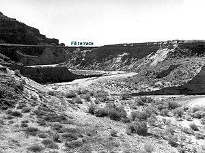
Fluvial terraces are elongated terraces that flank the sides of floodplain
s and fluvial
valley
s all over the world. They consist of a relatively level strip of land, called a “tread,” separated from either an adjacent floodplain, other fluvial terraces, or uplands by distinctly steeper strips of land called “risers.” These terraces lie parallel to and above the river
channel and its floodplain. Because of the manner in which they form, fluvial terraces are underlain by fluvial sediment
s of highly variable thickness.
Fluvial terraces are the remnants of earlier floodplains that existed at a time when either a stream
or river was flowing at a higher elevation before its channel downcut to create a new floodplain at a lower elevation. Changes in elevation can be due to changes in the base level (elevation of the lowest point in the fluvial system, usually the drainage basin
) of the fluvial system, which leads to headward erosion
along the length of either a stream or river, gradually lowering its elevation. For example, downcutting by a river can lead to increased velocity
of a tributary, causing that tributary to erode toward its headwaters. Terraces can also be left behind when the volume of the fluvial flow declines due to changes in climate
, typical of areas which were covered by ice
during periods of glaciation, and their adjacent drainage basins.
 Fill terraces: Fill terraces are the result of an existing valley being filled with alluvium
. The valley may fill with alluvium for many different reasons including: an influx in bed load
due to glaciation or change in stream power
which causes the valley, that was down cut by either a stream or river, to be filled in with material (Easterbrook). The stream or river will continue to deposit material until an equilibrium is reached and it can transport the material rather than deposit it. This equilibrium may last for a very short period, such as, after glaciation, or for a very long time if the conditions do not change. The fill terrace is created when the conditions change again and either a stream or river starts to incise into the material that it deposited in the valley. Once this occurs benches composed completely of alluvium form on the sides of the valley. The upper most benches are the fill terraces. As it continues to cut down through the alluvium the fill terraces are left above the river channel (sometimes 100 m or more). The fill terrace is only the very highest terrace resulting from the depositional episode, if there are multiple terraces below the fill terrace these are called cut terraces.
Cut terraces: Cut terraces, also called "cut-in-fill" terraces, are similar to the fill terraces mentioned above, but they are erosion
al in origin. Once the alluvium deposited in the valley has begun to erode and fill terraces form along the valley walls, cut terraces may also form below the fill terraces. As either a stream or river continues to incise into the material, multiple levels of terraces may form. The uppermost being the fill terraces and the remaining lower terraces are cut terraces.
Nested fill terraces: Nested fill terraces are the result of the valley filling with alluvium, the alluvium being incised, and the valley filling again with material but to a lower level than before. The terrace that results for the second filling is a nested terrace because it has been “nested” into the original alluvium and created a terrace. These terraces are depositional in origin and may be able to be identified by a sudden change in alluvium characteristics such as finer material for example.
Strath terraces: Strath terraces are the result of either a stream or river downcutting
through bedrock. As the it continues to downcut a period of valley widening may occur and expand the valley width. This may occur due to an equilibrium reached in the fluvial system resulting from: slowed or paused uplift, climate change, or a change in the bedrock type. Once downcutting continues the flattened valley bottom composed of bedrock (overlain with a possible thin layer of alluvium) is left above either a stream or river channel. These bedrock terraces are the strath terraces and are erosional in nature.
 Paired and unpaired terraces: Terraces of the same elevation on opposite sides of either a stream or river are called paired terraces. They occur when it downcuts evenly on both sides and terraces on one side of the river correspond in height with those on the other side. Paired terraces are caused by river rejuvenation
. Unpaired terraces occur when either a stream or river encounters material on one side that resists erosion, leaving a single terrace with no corresponding terrace on the resistant side.
Floodplain
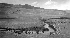
A floodplain, or flood plain, is a flat or nearly flat land adjacent a stream or river that stretches from the banks of its channel to the base of the enclosing valley walls and experiences flooding during periods of high discharge...
s and fluvial
Fluvial
Fluvial is used in geography and Earth science to refer to the processes associated with rivers and streams and the deposits and landforms created by them...
valley
Valley
In geology, a valley or dale is a depression with predominant extent in one direction. A very deep river valley may be called a canyon or gorge.The terms U-shaped and V-shaped are descriptive terms of geography to characterize the form of valleys...
s all over the world. They consist of a relatively level strip of land, called a “tread,” separated from either an adjacent floodplain, other fluvial terraces, or uplands by distinctly steeper strips of land called “risers.” These terraces lie parallel to and above the river
River
A river is a natural watercourse, usually freshwater, flowing towards an ocean, a lake, a sea, or another river. In a few cases, a river simply flows into the ground or dries up completely before reaching another body of water. Small rivers may also be called by several other names, including...
channel and its floodplain. Because of the manner in which they form, fluvial terraces are underlain by fluvial sediment
Sediment
Sediment is naturally occurring material that is broken down by processes of weathering and erosion, and is subsequently transported by the action of fluids such as wind, water, or ice, and/or by the force of gravity acting on the particle itself....
s of highly variable thickness.
Fluvial terraces are the remnants of earlier floodplains that existed at a time when either a stream
Stream
A stream is a body of water with a current, confined within a bed and stream banks. Depending on its locale or certain characteristics, a stream may be referred to as a branch, brook, beck, burn, creek, "crick", gill , kill, lick, rill, river, syke, bayou, rivulet, streamage, wash, run or...
or river was flowing at a higher elevation before its channel downcut to create a new floodplain at a lower elevation. Changes in elevation can be due to changes in the base level (elevation of the lowest point in the fluvial system, usually the drainage basin
Drainage basin
A drainage basin is an extent or an area of land where surface water from rain and melting snow or ice converges to a single point, usually the exit of the basin, where the waters join another waterbody, such as a river, lake, reservoir, estuary, wetland, sea, or ocean...
) of the fluvial system, which leads to headward erosion
Erosion
Erosion is when materials are removed from the surface and changed into something else. It only works by hydraulic actions and transport of solids in the natural environment, and leads to the deposition of these materials elsewhere...
along the length of either a stream or river, gradually lowering its elevation. For example, downcutting by a river can lead to increased velocity
Velocity
In physics, velocity is speed in a given direction. Speed describes only how fast an object is moving, whereas velocity gives both the speed and direction of the object's motion. To have a constant velocity, an object must have a constant speed and motion in a constant direction. Constant ...
of a tributary, causing that tributary to erode toward its headwaters. Terraces can also be left behind when the volume of the fluvial flow declines due to changes in climate
Climate
Climate encompasses the statistics of temperature, humidity, atmospheric pressure, wind, rainfall, atmospheric particle count and other meteorological elemental measurements in a given region over long periods...
, typical of areas which were covered by ice
Ice
Ice is water frozen into the solid state. Usually ice is the phase known as ice Ih, which is the most abundant of the varying solid phases on the Earth's surface. It can appear transparent or opaque bluish-white color, depending on the presence of impurities or air inclusions...
during periods of glaciation, and their adjacent drainage basins.
Types of fluvial terraces
There are two basic types of fluvial terraces, fill terraces and strath terraces. Fill terraces sometimes are further subdivided into in nested fill terraces and cut terraces. Both fill and strath terraces are, at times, described as being either paired or unpaired terraces based upon the relative elevations of the surface of these terraces.Alluvium
Alluvium is loose, unconsolidated soil or sediments, eroded, deposited, and reshaped by water in some form in a non-marine setting. Alluvium is typically made up of a variety of materials, including fine particles of silt and clay and larger particles of sand and gravel...
. The valley may fill with alluvium for many different reasons including: an influx in bed load
Bed load
The term bed load or bedload describes particles in a flowing fluid that are transported along the bed. Bed load is complementary to suspended load and wash load.Bed load moves by rolling, sliding, and/or saltating ....
due to glaciation or change in stream power
Stream power
Stream power is the rate of energy dissipation against the bed and banks of a river or stream per unit downstream length. It is given by the equation:\Omega=\rho g Q S...
which causes the valley, that was down cut by either a stream or river, to be filled in with material (Easterbrook). The stream or river will continue to deposit material until an equilibrium is reached and it can transport the material rather than deposit it. This equilibrium may last for a very short period, such as, after glaciation, or for a very long time if the conditions do not change. The fill terrace is created when the conditions change again and either a stream or river starts to incise into the material that it deposited in the valley. Once this occurs benches composed completely of alluvium form on the sides of the valley. The upper most benches are the fill terraces. As it continues to cut down through the alluvium the fill terraces are left above the river channel (sometimes 100 m or more). The fill terrace is only the very highest terrace resulting from the depositional episode, if there are multiple terraces below the fill terrace these are called cut terraces.
Cut terraces: Cut terraces, also called "cut-in-fill" terraces, are similar to the fill terraces mentioned above, but they are erosion
Erosion
Erosion is when materials are removed from the surface and changed into something else. It only works by hydraulic actions and transport of solids in the natural environment, and leads to the deposition of these materials elsewhere...
al in origin. Once the alluvium deposited in the valley has begun to erode and fill terraces form along the valley walls, cut terraces may also form below the fill terraces. As either a stream or river continues to incise into the material, multiple levels of terraces may form. The uppermost being the fill terraces and the remaining lower terraces are cut terraces.
Nested fill terraces: Nested fill terraces are the result of the valley filling with alluvium, the alluvium being incised, and the valley filling again with material but to a lower level than before. The terrace that results for the second filling is a nested terrace because it has been “nested” into the original alluvium and created a terrace. These terraces are depositional in origin and may be able to be identified by a sudden change in alluvium characteristics such as finer material for example.
Strath terraces: Strath terraces are the result of either a stream or river downcutting
Downcutting
Downcutting, also called erosional downcutting or downward erosion or vertical erosion is a geological process that deepens the channel of a stream or valley by removing material from the stream's bed or the valley's floor. How fast downcutting occurs depends on the stream's base level, which is...
through bedrock. As the it continues to downcut a period of valley widening may occur and expand the valley width. This may occur due to an equilibrium reached in the fluvial system resulting from: slowed or paused uplift, climate change, or a change in the bedrock type. Once downcutting continues the flattened valley bottom composed of bedrock (overlain with a possible thin layer of alluvium) is left above either a stream or river channel. These bedrock terraces are the strath terraces and are erosional in nature.
Rejuvenation (river)
A river is said to be rejuvenated when the base level that it is flowing down to is lowered. This can happen for various reasons.-Signs:Rejuvenated terrains usually have complex landscapes because remnants of older landforms are locally preserved. Parts of floodplains may be preserved as terraces...
. Unpaired terraces occur when either a stream or river encounters material on one side that resists erosion, leaving a single terrace with no corresponding terrace on the resistant side.
Fluvial terrace applications
Fluvial terraces can be used to measure the rate at which either a stream or river is downcutting its valley. Using various dating methods, an age can be determined for the deposition of the terrace. Using the resulting date and the elevation above its current level and approximate average rate of downcutting can be determined.See also
- benchBench (geology)In geomorphology, geography and geology, a bench or benchland is a long, relatively narrow strip of relatively level or gently inclined land that is bounded by distinctly steeper slopes above and below it...
- FloodplainFloodplainA floodplain, or flood plain, is a flat or nearly flat land adjacent a stream or river that stretches from the banks of its channel to the base of the enclosing valley walls and experiences flooding during periods of high discharge...
- LandformLandformA landform or physical feature in the earth sciences and geology sub-fields, comprises a geomorphological unit, and is largely defined by its surface form and location in the landscape, as part of the terrain, and as such, is typically an element of topography...
- Musashino TerraceMusashino TerraceThe Musashino Terrace , also translated as Musashino Platform, is a large platform of land, known as a river terrace, in the Kantō region of Honshū, Japan....
- Terrace (geology)