

U.S. Route 26
Encyclopedia
U.S. Route 26 is an east–west United States highway. It started in Ogallala
, Nebraska
, and gradually grew to reach the West Coast
in Oregon
. When the U.S. highway system was first defined, it was limited to Nebraska and Wyoming
; by the 1950s, it continued into Idaho
and Oregon. The highway's eastern terminus is in Ogallala, Nebraska
at an intersection with Interstate 80
. Its western terminus is south of Seaside, Oregon
at an intersection with U.S. Route 101. Prior to 2004, the route's last 20 miles (32 km) were co-signed with U.S. Route 101 from the highways' junction south of Seaside north to Astoria
where its intersection with U.S. Route 30 was also U.S. 30's western terminus.
Much of the highway follows the path of the historic Oregon Trail
. At its peak, immediately before the establishment of the interstate highway system, US 26 was 1,557 miles (2506 km) in length, and terminated in Astoria, Oregon
.
 Starting at a junction with U.S. Highway 101 near Seaside, Oregon
, U.S. Highway 26 heads southeast through the Coast Range
to Portland
. In the western Portland area, US 26 is a freeway known as the Sunset Highway
. After passing through the Vista Ridge Tunnel, heading into downtown Portland, it intersects with Interstate 405
and runs along the interstate southbound for about a half-mile before exiting onto surface streets at the waterfront, meeting Oregon Route 43 at Macadam Avenue before crossing Interstate 5. After crossing the Willamette River
and meeting at an incomplete interchange with Oregon Route 99E, US26 then heads east on Powell Boulevard where it crosses Interstate 205
and continues east to Sandy on what is known as the Mount Hood Highway No. 26 (see Oregon Routes and Highways), a four-lane divided highway that was supposed to be the Mount Hood Freeway, which was never built just south of Division St.
After passing through Sandy, Highway 26 (known there as the Mount Hood Highway) continues on towards Government Camp and Bennett Pass, where it eventually meets up with Oregon Route 35. The Mount Hood Highway continues north along Oregon Route 35, while Highway 26 heads southeast towards Madras, where it intersects with U.S. Route 97
. It then continues southeast to Prineville, where it meets Oregon Route 126 and heads east through John Day
where it meets U.S. Route 20
in Vale
. The remainder of Highway 26 follows U.S. Route 20
to the Idaho
state line.
, with short multiplexes with U.S. Highway 95 near Parma and Interstate 84
at Caldwell
. At Boise, U.S. 26/U.S. 20 merges with I-84 for about 40 miles until Mountain Home
, where U.S. 20 splits from U.S. 26/I-84. About 41 miles later in Bliss
, U.S. 26 splits from I-84 for 66 miles until again joining U.S. 20 at Carey
, skirting the north edge of Craters of the Moon National Monument. Near Idaho National Engineering Laboratory, U.S. 26 again splits from U.S. 20 to the southeast, proceeding to Blackfoot
, where U.S. 26 joins Interstate 15
for about 20 miles before splitting just south of Idaho Falls toward Alpine, Wyoming
.
 From Alpine, US 26 is co-signed with U.S. Route 89
east and north to Hoback Junction, then co-signed with US 89, U.S. Route 189
, and U.S. Route 191
to Jackson
. US 189 ends in Jackson, and the other three highways continue their concurrency through Grand Teton National Park
up to Moran. US 26 turns east here, concurrent with U.S. Route 287
. At Diversion Dam Junction, US 26 and US 287 separate; US 26 continues southeast to Riverton
, then northeast to Shoshoni
. From Shoshoni to Casper
, US 26 is co-signed with U.S. Highway 20. US 20-26 has a bypass north of Casper, the eastern half of which is concurrent with Interstate 25 and U.S. Route 87
. US 20-26-87 parallels I-85 from Casper to Glenrock
; east of Glenrock US 26 (along with US 20 and US 87) is co-signed on I-25. US 26 follows I-25 to Dwyer Junction, where it turns east to continue along the Old Oregon Trail
. US 26 passes through Guernsey
, Fort Laramie
, Lingle
, and Torrington
before entering Nebraska. U.S. Route 85
is concurrent with US 26 between Lingle and Torrington.
. The largest city US 26 runs through in Nebraska is Scottsbluff
, which is just 22 miles (35 km) from the Wyoming border. US 26 also goes past the Chimney Rock National Historic Site
. US 26 intersects with U.S. Highway 385 in Bridgeport
and then continues to its eastern terminus in Ogallala, Nebraska at Interstate 80
. All told, there are 145 miles (233 km) of US 26 in the state of Nebraska.
. It became WYO 320 in 1938, which was extended southwest to Lander in 1940 when US 287 (which had replaced US 87W) was realigned. The original part of US 320/WYO 320 became part of an extension of US 26 in 1950, and the rest of WYO 320 became part of WYO 789 in 1954.
Ogallala, Nebraska
Ogallala is a city in Keith County, Nebraska, United States. The population was 4,737 at the 2010 census. It is the county seat of Keith County. In the days of the Nebraska Territory, the city was a stop on the Pony Express and later along the transcontinental railroad...
, Nebraska
Nebraska
Nebraska is a state on the Great Plains of the Midwestern United States. The state's capital is Lincoln and its largest city is Omaha, on the Missouri River....
, and gradually grew to reach the West Coast
West Coast of the United States
West Coast or Pacific Coast are terms for the westernmost coastal states of the United States. The term most often refers to the states of California, Oregon, and Washington. Although not part of the contiguous United States, Alaska and Hawaii do border the Pacific Ocean but can't be included in...
in Oregon
Oregon
Oregon is a state in the Pacific Northwest region of the United States. It is located on the Pacific coast, with Washington to the north, California to the south, Nevada on the southeast and Idaho to the east. The Columbia and Snake rivers delineate much of Oregon's northern and eastern...
. When the U.S. highway system was first defined, it was limited to Nebraska and Wyoming
Wyoming
Wyoming is a state in the mountain region of the Western United States. The western two thirds of the state is covered mostly with the mountain ranges and rangelands in the foothills of the Eastern Rocky Mountains, while the eastern third of the state is high elevation prairie known as the High...
; by the 1950s, it continued into Idaho
Idaho
Idaho is a state in the Rocky Mountain area of the United States. The state's largest city and capital is Boise. Residents are called "Idahoans". Idaho was admitted to the Union on July 3, 1890, as the 43rd state....
and Oregon. The highway's eastern terminus is in Ogallala, Nebraska
Ogallala, Nebraska
Ogallala is a city in Keith County, Nebraska, United States. The population was 4,737 at the 2010 census. It is the county seat of Keith County. In the days of the Nebraska Territory, the city was a stop on the Pony Express and later along the transcontinental railroad...
at an intersection with Interstate 80
Interstate 80
Interstate 80 is the second-longest Interstate Highway in the United States, following Interstate 90. It is a transcontinental artery running from downtown San Francisco, California to Teaneck, New Jersey in the New York City Metropolitan Area...
. Its western terminus is south of Seaside, Oregon
Seaside, Oregon
Seaside is a city in Clatsop County, Oregon, United States. The name Seaside is derived from Seaside House, a historic summer resort built in the 1870s by railroad magnate Ben Holladay. The city's population was 6,457 at the 2010 census.-History:...
at an intersection with U.S. Route 101. Prior to 2004, the route's last 20 miles (32 km) were co-signed with U.S. Route 101 from the highways' junction south of Seaside north to Astoria
Astoria, Oregon
Astoria is the county seat of Clatsop County, Oregon, United States. Situated near the mouth of the Columbia River, the city was named after the American investor John Jacob Astor. His American Fur Company founded Fort Astoria at the site in 1811...
where its intersection with U.S. Route 30 was also U.S. 30's western terminus.
Much of the highway follows the path of the historic Oregon Trail
Oregon Trail
The Oregon Trail is a historic east-west wagon route that connected the Missouri River to valleys in Oregon and locations in between.After 1840 steam-powered riverboats and steamboats traversing up and down the Ohio, Mississippi and Missouri rivers sped settlement and development in the flat...
. At its peak, immediately before the establishment of the interstate highway system, US 26 was 1,557 miles (2506 km) in length, and terminated in Astoria, Oregon
Astoria, Oregon
Astoria is the county seat of Clatsop County, Oregon, United States. Situated near the mouth of the Columbia River, the city was named after the American investor John Jacob Astor. His American Fur Company founded Fort Astoria at the site in 1811...
.
Oregon
Seaside, Oregon
Seaside is a city in Clatsop County, Oregon, United States. The name Seaside is derived from Seaside House, a historic summer resort built in the 1870s by railroad magnate Ben Holladay. The city's population was 6,457 at the 2010 census.-History:...
, U.S. Highway 26 heads southeast through the Coast Range
Oregon Coast Range
The Oregon Coast Range, often called simply the Coast Range and sometimes the Pacific Coast Range, is a mountain range, in the Pacific Coast Ranges physiographic region, in the U.S. state of Oregon along the Pacific Ocean...
to Portland
Portland, Oregon
Portland is a city located in the Pacific Northwest, near the confluence of the Willamette and Columbia rivers in the U.S. state of Oregon. As of the 2010 Census, it had a population of 583,776, making it the 29th most populous city in the United States...
. In the western Portland area, US 26 is a freeway known as the Sunset Highway
Sunset Highway (Oregon)
The Sunset Highway No. 47 , in the state of Oregon, is an official designation for the portion of U.S. Route 26 between its western terminus, south of Seaside, and the interchange with Interstate 405 in downtown Portland...
. After passing through the Vista Ridge Tunnel, heading into downtown Portland, it intersects with Interstate 405
Interstate 405 (Oregon)
Interstate 405 is a short Interstate Highway in Portland, Oregon. It forms a loop from Interstate 5 that travels through downtown Portland west of the Willamette River.-Route description:...
and runs along the interstate southbound for about a half-mile before exiting onto surface streets at the waterfront, meeting Oregon Route 43 at Macadam Avenue before crossing Interstate 5. After crossing the Willamette River
Willamette River
The Willamette River is a major tributary of the Columbia River, accounting for 12 to 15 percent of the Columbia's flow. The Willamette's main stem is long, lying entirely in northwestern Oregon in the United States...
and meeting at an incomplete interchange with Oregon Route 99E, US26 then heads east on Powell Boulevard where it crosses Interstate 205
Interstate 205 (Oregon-Washington)
Interstate 205 is a loop route that serves the Portland—Vancouver metropolitan area in the U.S. states of Oregon and Washington. I-205 is officially named the War Veterans Memorial Freeway, and is also known as the East Portland Freeway...
and continues east to Sandy on what is known as the Mount Hood Highway No. 26 (see Oregon Routes and Highways), a four-lane divided highway that was supposed to be the Mount Hood Freeway, which was never built just south of Division St.
After passing through Sandy, Highway 26 (known there as the Mount Hood Highway) continues on towards Government Camp and Bennett Pass, where it eventually meets up with Oregon Route 35. The Mount Hood Highway continues north along Oregon Route 35, while Highway 26 heads southeast towards Madras, where it intersects with U.S. Route 97
U.S. Route 97
U.S. Route 97 is a major north–south United States highway in the western United States. It begins at a junction with Interstate 5 at Weed, California, and travels north, ending in Okanogan County, Washington, at the Canadian Border, across from Osoyoos, British Columbia, becoming British...
. It then continues southeast to Prineville, where it meets Oregon Route 126 and heads east through John Day
John Day, Oregon
John Day is a city located about north of Canyon City in Grant County, Oregon, at the intersection of U.S. Routes 26 and 395. The city was named for the nearby John Day River, which had been named for a Virginian member of the 1811 Astor Expedition, John Day...
where it meets U.S. Route 20
U.S. Route 20
U.S. Route 20 is an east–west United States highway. As the "0" in its route number implies, US 20 is a coast-to-coast route. Spanning , it is the longest road in the United States, and the route sparsely parallels Interstate 90...
in Vale
Vale, Oregon
Vale is a city in Malheur County, Oregon, United States, about west of the Idaho border. It is at the intersection of U.S. Routes 20 and 26, on the Malheur River.Vale was selected as Malheur's county seat in 1955, 68 years after the county was founded...
. The remainder of Highway 26 follows U.S. Route 20
U.S. Route 20
U.S. Route 20 is an east–west United States highway. As the "0" in its route number implies, US 20 is a coast-to-coast route. Spanning , it is the longest road in the United States, and the route sparsely parallels Interstate 90...
to the Idaho
Idaho
Idaho is a state in the Rocky Mountain area of the United States. The state's largest city and capital is Boise. Residents are called "Idahoans". Idaho was admitted to the Union on July 3, 1890, as the 43rd state....
state line.
Idaho
From the Oregon state line, U.S. 26 continues to follow U.S. 20 to BoiseBoise, Idaho
Boise is the capital and most populous city of the U.S. state of Idaho, as well as the county seat of Ada County. Located on the Boise River, it anchors the Boise City-Nampa metropolitan area and is the largest city between Salt Lake City, Utah and Portland, Oregon.As of the 2010 Census Bureau,...
, with short multiplexes with U.S. Highway 95 near Parma and Interstate 84
Interstate 84 (west)
Interstate 84 is an Interstate Highway in the Western United States that runs from Portland, Oregon, to a junction with Interstate 80 near Echo, Utah. The highway originally served as a fork of I-80 to serve the Pacific Northwest, and was originally numbered Interstate 80N.The highway serves and...
at Caldwell
Caldwell, Idaho
Caldwell is a city in and the county seat of Canyon County, Idaho, United States. The U.S. Census Bureau estimated the population to be 43,281, as of July 2009.Caldwell is the home of the College of Idaho. It is considered part of the Boise metropolitan area....
. At Boise, U.S. 26/U.S. 20 merges with I-84 for about 40 miles until Mountain Home
Mountain Home, Idaho
Mountain Home is the largest city and county seat of Elmore County, Idaho. The population was 14,206 at the 2010 census. Mountain Home is the principal city of the Mountain Home, ID Micropolitan Statistical Area, which includes Elmore County....
, where U.S. 20 splits from U.S. 26/I-84. About 41 miles later in Bliss
Bliss, Idaho
Bliss is a city in Gooding County, Idaho, United States. The population was 275 at the 2000 census.-Geography:Bliss is located at .According to the United States Census Bureau, the city has a total area of , all land....
, U.S. 26 splits from I-84 for 66 miles until again joining U.S. 20 at Carey
Carey, Idaho
Carey is a city in Blaine County, Idaho, United States. The population was 513 at the 2000 census. Carey is primarily an agricultural city and is the location of the Blaine County Fairgrounds. Nearby recreational destinations include the Craters of the Moon National Monument, Carey Lake, Silver...
, skirting the north edge of Craters of the Moon National Monument. Near Idaho National Engineering Laboratory, U.S. 26 again splits from U.S. 20 to the southeast, proceeding to Blackfoot
Blackfoot, Idaho
Blackfoot is a city in Bingham County, Idaho, United States. The population was 10,419 at the 2000 census. The city is the county seat of Bingham County. Blackfoot is self-designated the "Potato Capital of the World", because it claims to have the largest potato industry in the world...
, where U.S. 26 joins Interstate 15
Interstate 15
Interstate 15 is the fourth-longest north–south Interstate Highway in the United States, traveling through the states of California, Nevada, Arizona, Utah, Idaho, and Montana from San Diego to the Canadian border...
for about 20 miles before splitting just south of Idaho Falls toward Alpine, Wyoming
Alpine, Wyoming
Alpine is a town in Lincoln County, Wyoming, United States. The population was 550 at the 2000 census.-Geography:Alpine is located at the southern end of the Snake River Canyon where the Snake River enters Palisades Reservoir. The town is also known as Alpine Junction since it marks the point...
.
Wyoming
U.S. Route 89
U.S. Route 89 is a north–south United States Highway with two sections, and one former section. The southern section runs for 848 miles from Flagstaff, Arizona, to the southern entrance of Yellowstone National Park...
east and north to Hoback Junction, then co-signed with US 89, U.S. Route 189
U.S. Route 189
U.S. Route 189 is a spur of U.S. Route 89. It currently runs for 322 miles from Provo, Utah at Interstate 15 to Jackson, Wyoming. The highway was not part of the original 1926 U.S. Highway system. The highway was created in the 1930s, absorbing former U.S. Route 530 and a portion of U.S. Route 30S...
, and U.S. Route 191
U.S. Route 191
U.S. Route 191 is a spur of U.S. Route 91 that has two branches. The southern branch runs for 1,465 miles from Douglas, Arizona on the Mexican border to the southern part of Yellowstone National Park. The northern branch runs for 440 miles from the northern part of Yellowstone National Park to...
to Jackson
Jackson, Wyoming
Jackson is a town located in the Jackson Hole valley of Teton County, Wyoming, United States. The population was 8,647 at the 2000 census. It is the county seat of Teton County....
. US 189 ends in Jackson, and the other three highways continue their concurrency through Grand Teton National Park
Grand Teton National Park
Grand Teton National Park is a United States National Park located in northwestern Wyoming, U.S. The Park consists of approximately and includes the major peaks of the long Teton Range as well as most of the northern sections of the valley known as Jackson Hole. Only south of Yellowstone...
up to Moran. US 26 turns east here, concurrent with U.S. Route 287
U.S. Route 287
U.S. Route 287 is a north–south United States highway. It is long. It serves as the major truck route between the Texas cities of Fort Worth and Amarillo...
. At Diversion Dam Junction, US 26 and US 287 separate; US 26 continues southeast to Riverton
Riverton, Wyoming
Riverton is a city in Fremont County, Wyoming, United States. It is both the largest city in the county and the largest within the historical boundaries of the Wind River Indian Reservation. The city's population was 9,310 at the 2000 census...
, then northeast to Shoshoni
Shoshoni, Wyoming
Shoshoni is a town in Fremont County, Wyoming, United States. The population was 635 at the 2000 census. The town is named for the Shoshone tribe of Native Americans, most of whom live on the nearby Wind River Indian Reservation...
. From Shoshoni to Casper
Casper, Wyoming
Casper is the county seat of Natrona County, Wyoming, United States.. Casper is the second-largest city in Wyoming , according to the 2010 census, with a population of 55,316...
, US 26 is co-signed with U.S. Highway 20. US 20-26 has a bypass north of Casper, the eastern half of which is concurrent with Interstate 25 and U.S. Route 87
U.S. Route 87
U.S. Highway 87 is a north–south United States highway that runs for 1,998 miles from northern Montana to southern Texas. Most of the portion from Billings, Montana, to Raton, New Mexico, is co-signed along Interstates 90 and 25...
. US 20-26-87 parallels I-85 from Casper to Glenrock
Glenrock, Wyoming
Glenrock is a town in Converse County, Wyoming, United States. The population was 2,231 at the 2000 census.Glenrock, known as Deer Creek Station, had its beginning as a mail and stage station along the Oregon Trail. The station served as a relay and eating place and was a vital supply point for...
; east of Glenrock US 26 (along with US 20 and US 87) is co-signed on I-25. US 26 follows I-25 to Dwyer Junction, where it turns east to continue along the Old Oregon Trail
Oregon Trail
The Oregon Trail is a historic east-west wagon route that connected the Missouri River to valleys in Oregon and locations in between.After 1840 steam-powered riverboats and steamboats traversing up and down the Ohio, Mississippi and Missouri rivers sped settlement and development in the flat...
. US 26 passes through Guernsey
Guernsey, Wyoming
Guernsey is a town in Platte County, Wyoming, United States. The population was 1,147 at the 2000 census.-Geography:Guernsey is located at ....
, Fort Laramie
Fort Laramie, Wyoming
Fort Laramie is a town in Goshen County, Wyoming, United States. The population was 243 at the 2000 census. The town is named after historic Fort Laramie, an important stop on the Oregon, California and Mormon trails as well as a staging point for various military excursions...
, Lingle
Lingle, Wyoming
Lingle is a town in Goshen County, Wyoming, United States. The population was 510 at the 2000 census.Former Wyoming Supreme Court Justice Richard V...
, and Torrington
Torrington, Wyoming
Torrington is a city in and the county seat of Goshen County, Wyoming, United States. The population was 5,776 at the 2000 census. Torrington is the home of Eastern Wyoming College....
before entering Nebraska. U.S. Route 85
U.S. Route 85
U.S. Route 85 is a north–south United States highway that runs for in the Mountain - Northern Plains states of the United States. The southern terminus of the route is at the United States-Mexico border in El Paso, Texas, connecting with Mexican Federal Highway 45...
is concurrent with US 26 between Lingle and Torrington.
Nebraska
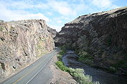
US 26 runs southeastward parallel to the North Platte RiverNorth Platte River
The North Platte River is a major tributary of the Platte River and is approximately long counting its many curves, It travels about distance. Its course lies in the U.S...
. The largest city US 26 runs through in Nebraska is Scottsbluff
Scottsbluff, Nebraska
Scottsbluff is a city in Scotts Bluff County, Nebraska, United States. The population was 15,039 at the 2010 census. Scottsbluff is the largest city in the Nebraska Panhandle, and the 13th largest city in Nebraska....
, which is just 22 miles (35 km) from the Wyoming border. US 26 also goes past the Chimney Rock National Historic Site
Chimney Rock National Historic Site
Chimney Rock is a prominent geological rock formation in Morrill County in western Nebraska. Rising nearly 300 feet above the surrounding North Platte River valley, the peak of Chimney Rock is above sea level. During the middle 19th century it served as a landmark along the Oregon Trail, the...
. US 26 intersects with U.S. Highway 385 in Bridgeport
Bridgeport, Nebraska
Bridgeport is a city in Morrill County, Nebraska, United States. The population was 1,594 at the 2000 census. It is the county seat of Morrill County.-Geography:Bridgeport is located at ....
and then continues to its eastern terminus in Ogallala, Nebraska at Interstate 80
Interstate 80
Interstate 80 is the second-longest Interstate Highway in the United States, following Interstate 90. It is a transcontinental artery running from downtown San Francisco, California to Teaneck, New Jersey in the New York City Metropolitan Area...
. All told, there are 145 miles (233 km) of US 26 in the state of Nebraska.
History
U.S. Highway 320 was part of the initial 1926 system, connecting US 20 at Shoshoni with US 87W at Riverton, WyomingRiverton, Wyoming
Riverton is a city in Fremont County, Wyoming, United States. It is both the largest city in the county and the largest within the historical boundaries of the Wind River Indian Reservation. The city's population was 9,310 at the 2000 census...
. It became WYO 320 in 1938, which was extended southwest to Lander in 1940 when US 287 (which had replaced US 87W) was realigned. The original part of US 320/WYO 320 became part of an extension of US 26 in 1950, and the rest of WYO 320 became part of WYO 789 in 1954.