

Chiapas
Encyclopedia
Chiapas (ˈtʃjapas) officially Estado Libre y Soberano de Chiapas (Free and Sovereign State of Chiapas) is one of the 31 states that, with the Federal District
, comprise the 32 Federal Entities of Mexico
. It is divided in 118 municipalities
and its capital city is Tuxtla Gutierrez
. Other important cites in Chiapas include San Cristóbal de las Casas
, Comitán
, and Tapachula
. Located in Southwestern Mexico
, it is the southernmost State of Mexico. It is bordered by the states of Tabasco
to the north, Veracruz
to the northwest and Oaxaca
to the west. To the east Chiapas borders Guatemala
, and to the south the Pacific Ocean
.
In general, Chiapas has a humid, tropical climate. In the north, in the area bordering Tabasco, near Teapa, rainfall can average more than 3000 mm (118.1 in) per year. In the past, natural vegetation at this region was lowland, tall perennial rainforest
, but this vegetation has been destroyed almost completely to give way to agriculture and ranching. Rainfall decreases moving towards the Pacific Ocean
, but it is still abundant enough to allow the farming of bananas and many other tropical crops near Tapachula
. On the several parallel "sierras" or mountain ranges running along the center of Chiapas, climate can be quite temperate and foggy, allowing the development of cloud forests like those of the Reserva de la Biosfera el Triunfo, home to a handful of Resplendent Quetzal
s and Horned Guan
s.
Chiapas is home to the ancient Maya
n ruins of Palenque
, Yaxchilán
, Bonampak
, Chinkultic
. It is also home to one of the largest indigenous populations in the country with twelve federally recognized ethnicities. Much of the state’s history is centered on the subjugation of these peoples with occasional rebellions. The last of these rebellions was the 1994 Zapatista uprising, which succeeded in obtaining new rights for indigenous people but also divided much of the indigenous peoples of the state.
, Veracruz
and Oaxaca
with the Pacific Ocean
to the south and Guatemala
to the east. It has a territory of 74,415 km2, the eighth largest state in Mexico. The state consists of 118 municipalities organized into nine political regions called Center, Altos, Fronteriza, Frailesca, Norte, Selva, Sierra, Soconusco and Istmo-Costa. There are 18 cities, twelve towns (villas) and 111 pueblos (villages). Major cities include Tuxtla Gutiérrez
, San Cristóbal de las Casas
, Tapachula
, Palenque
, Comitán, and Chiapas de Corzo.
 The state has a complex geography with seven distinct regions according to the Mullerried classification system. These include the Pacific Coast Plains, the Sierra Madre de Chiapas, the Central Depression, the Central Highlands, the Eastern Mountains, the Northern Mountains and the Gulf Coast Plains. The Pacific Coast Plains is a strip of land parallel to the ocean. It is composed mostly of sediment from the mountains that border it on the northern side. It is uniformly flat, and stretches from the Bernal Mountain south to Tonalá
. It has deep salty soils due to its proximity to the sea. It has mostly deciduous rainforest although most has been converted to pasture for cattle and fields for crops. It has numerous estuaries
with mangroves and other aquatic vegetation.
The Sierra Madre de Chiapas
runs parallel to the Pacific coastline of the state, northwest to southeast as a continuation of the Sierra Madre del Sur
. This area has the highest altitudes in Chiapas including the Tacaná Volcano
, which rises 4,093 meters above sea level. Most of these mountains are volcanic in origin although the nucleus is metamorphic rock. It has a wide range of climates but little arable land. It is mostly covered in middle altitude rainforest, high altitude rainforest, and forests of oaks and pines. The mountains partially block rain clouds from the Pacific, a process known as Orographic lift
, which creates a particularly rich coastal region called the Soconusco
. The main commercial center of the sierra is the town of Motozintla
, also near the Guatemalan border.
The Central Depression is in the center of the state. It is an extensive semi flat area bordered by the Sierra Madre de Chiapas, the Central Highlands and the Northern Mountains. Within the depression there are a number of distinct valleys. The climate here can be very hot and humid in the summer, especially due to the large volume of rain received in July and August. The original vegetation was lowland deciduous rainforest with some rainforest of middle altitudes and some oaks above 1500masl.
The Central Highlands, also referred to as Los Altos, are mountains oriented from northwest to southeast with altitudes ranging from twelve to sixteen hundred meters above sea level. The western highlands are displaced faults, while the eastern highlands are mainly folds of sedimentary formations—mainly limestone
, shale
, and sandstone
. These mountains, along the Sierra Madre of Chiapas become the Cuchumatanes where they extend over the border into Guatemala. Its topography is mountainous with many narrow valleys and karst
formations called uvalas or poljés, depending on the size. Most of the rock is limestone
allowing for a number of formations such as caves and sinkholes. There are also some isolated pockets of volcanic rock with the tallest peaks being the Tzontehuitz and Huitepec volcanos. There are no significant surface water systems as they are almost all underground. The original vegetation was forest of oak and pine but these have been heavily damaged. The highlands climate in the Koeppen modified classification
system for Mexico is humid temperate C(m) and subhumid temperate C(w 2 )(w). This climate exhibits a summer rainy season and a dry winter, with possibilities of frost from December to March. The Central Highlands have been the population center of Chiapas since the Conquest. European epidemics were hindered by the tierra fría
climate, allowing the indigenous peoples in the highlands to retain their large numbers.
The Eastern Mountains (Montañas del Oriente) are in the east of the state, formed by various parallel mountain chains mostly made of limestone and sandstone. Its altitude varies from 500 to 1500 masl. This area receives moisture from the Gulf of Mexico
with abundant rainfall and exhuberant vegetation, which creates the Lacandon Jungle
, one of the most important rainforests in Mexico. The Northern Mountains (Montañas del Norte) are in the north of the state. They separate the flatlands of the Gulf Coast Plains from the Central Depression. Its rock is mostly limestone. These mountains also receive large amounts of rainfall with moisture from the Gulf of Mexico giving it a mostly hot and humid climate with rains year round. In the highest elevations around 1800 masl, temperatures are somewhat cooler and do experience a winter. The terrain is rugged with small valleys whose natural vegetation is high altitude rainforest.
The Gulf Coast Plains (Llanura Costera del Golfo) stretch into Chiapas from the state of Tabasco, which gives it the alternate name of the Tabasqueña Plains. These plains are found only in the exteme north of the state. The terrain is flat and prone to flooding during the rainy season as it was built by sediments deposited by rivers and streams heading to the Gulf.
and into Belize
. This area contains as much as 25% of Mexico's total species diversity, most of which has not been researched. It has a predominately hot and humid climate (Am w" i g) with most rain falling from summer to part of fall, with an average of between 2300 and 2600 mm per year. There is a short dry season from March to May. The predominate wild vegetation is perennial high rainforest. The Lacandon comprises a biosphere reserve (Montes Azules); four natural protected areas (Bonampak
, Yaxchilan
, Chan Kin, and Lacantum); and the communal reserve (La Cojolita), which functions as a biological corridor with the area of Petén
in Guatemala. Flowing within the Rainforest is the Usumacinta River
, considered to be one of the largest rivers in Mexico and seventh largest in the world based on volume of water.
During the 20th century, the Lacandon has had a dramatic increase in population and along with it, severe deforestation
. The population of municipalities in this area, Altamirano
, Las Margaritas
, Ocosingo
and Palenque
have risen from 11,000 in 1920 to over 376,000 in 2000. Migrants incude Ch'ol, Tzeltal, Tzotzil, Tojolabal
indigenous peoples along with mestizos, Guatemalan refugees and others. Most of these migrants are peasant farmers, who cut forest to plant crops. However, the soil of this area cannot support annual crop farming for more than three or four harvents. The increase in population and the need to move on to new lands has pitted migrants against each other, the native Lacandon people, and the various ecological reserves for land. It is estimated that only ten percent of the original Lacandon rainforest in Mexico remains, with the rest strip-mined, logged and farmed. It once stretched over a large part of eastern Chiapas but all that remains is along the northern edge of the Guatemalan border. Of this remaining portion, Mexico is losing over five percent each year.
The best preserved portion of the Lacandon is within the Montes Azules Biosphere Reserve. It is centered on what was a commercial logging grant by the Porfirio Díaz
government, which the government later nationalized. However, this nationalization and conversion into a reserve has made it one of the most contested lands in Chiapas, with the already existing ejidos and other settlements within the park along with new arrivals squatting on the land.
region encompasses a coastal plain and a mountain range with elevations of up to 2000 meters above sea levels paralleling the Pacific Coast. The highest peak in Chiapas is the Tacaná Volcano
at 4,800 meters above sea level. In accordance with an 1882 treaty, the dividing line between Mexico and Guatemala goes right over the summit of this volcano. The climate is tropical, with a number of rivers and evergreen forests in the mountains. This is Chiapas’ major coffee producing area, as it has the best soils and climate for coffee.
Before the arrival of the Spanish, this area was the principal source of cocoa seeds in the Aztec empire, which they used as currency, and for the highly prized quetzal
feathers used by the nobility. It would become the first area to produce coffee, introduced by an Italian entrepreneur on the La Chacara farm. Coffee is cultivated on the slopes of these mountains mostly between 600 and 1200 masl. Mexico produces about 4 million sacks of green coffee each year, fifth in the world behind Brazil
, Colombia
, Indonesia
and Vietnam
. Most producers are small with plots of land under five hectares. From November to January, the annual crop is harvested and processed employing thousands of seasonal workers. Lately, a number of coffee haciendas have been developing tourism infrastructure as well.
Chiapas' rainforests are home to thousands of unique animals and plants, some of which cannot be found anywhere else in the world. Natural vegetation varies from lowland to highland tropical forest, pine and oak forests in the highest altitudes and plains area with some grassland. Chiapas is ranked second in forest resources in Mexico with valued woods such as pine, cypress
, Liquidambar, oak
, cedar
, mahogany
and more. The Lacandon Jungle
is one of the last major tropical rainforests in the northern hemisphere with an extension of 600,000 hectares. It contsina about sixty percent of Mexico’s tropical tree species, 3,500 species of plants, 1,157 species of invertebrates and over 500 of vertebrate species. Chiapas has one of the greatest diversities in wildlife in the Americas. There are more than 100 species of amphibians, 700 species of birds, fifty of mammals and just over 200 species of reptiles. In the hot lowlands, there are armadillo
s, monkey
s, pelican
s, wild boar, jaguar
s, crocodile
s, iguana
s and many others. In the temperate regions there are species such as bobcat
s, salamander
s, a large red lizard Abronia lythrochila
, weasel
s, opossums, deer
, ocelot
s and bats. The coastal areas have large quantities of fish, turtles, and crustacean
s, with many species in danger of extinction or endangered as they are endemic only to this area. The total biodiversity of the state is estimated at over 50,000 species of plants and animals. The diversity of species is not limited to the hot lowlands but in the higher altitudes as well with mesophile
forests, oak/pine forests in the Los Altos, Northern Mountains and Sierra Madre and the extensive estuaries
and mangrove
wetlands along the coast.
Chiapas has about thirty percent of Mexico’s fresh water resources. The Sierra Madre divides these into those that flow to the Pacific and those that flow to the Gulf of Mexico. Most of the first are short rivers and streams; most longer ones flowing to the Gulf. Most Pacific side rivers do not drain directly into this ocean but into lagoon
s and estuaries. The two largest rivers are the Grijalva
and the Usumacinta
, with both part of the same system. The Grijalva has four dams built on it the Belisario Dominguez (La Angostura); Manuel Moreno Torres (Chicoasén); Nezahualcóyotl (Malpaso); and Angel Albino Corzo (Peñitas). The Usumacinta divides the state from Guatemala and is the longest river in Central America
. In total, the state has 110,000 hectares of surface waters, 260 km of coastline, control of 96,000 km2 of ocean, 75,230 hectares of estuaries and ten lake systems. Laguna Miramar is a lake in the Montes Azules reserve and the largest in the Lacandon Jungle at 40 km in diameter. The color of its waters vary from indigo
to emerald
green and in ancient times, there were settlements on its islands and its caves on the shoreline. The Catazajá Lake is 28 km north of the city of Palenque
. It is formed by rainwater captured as it makes it way to the Usumacinta River. It contains wildlife such as manatee
s and iguana
s and it is surrounded by rainforest. Fishing on this lake is an ancient tradition and the lake has an annual bass fishing tournament. The Welib Já Waterfall is located on the road between Palenque and Bonampak.
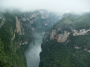
The state has thirty six protected areas at the state and federal levels along with 67 areas protected by various municipalities. The Sumidero Canyon National Park was decreed in 1980 with an extension of 21,789 hectares. It extends over two of the regions of the state, the Central Depression and the Central Highlands over the municipalities of Tuxtla Gutiérrez
, Nuevo Usumacinta, Chiapa de Corzo
and San Fernando
. The canyon
has steep and vertical sides that rise to up to 1000 meters from the river below with mostly tropical rainforest but some areas with xerophile
vegetation such as cactus can be found. The river below is called the Grijalva
, which has cut the canyon over the course of twelve million years. The canyon is emblematic for the state as it is featured in the state seal. The Sumidero Canyon was once the site of an epic battle between the Spainiards and Chiapanecan Indians. Many Chiapanecans chose to throw themselves from the high edges of the canyon rather than be defeated by Spanish forces. Today, the canyon is a popular destination for ecotourism
. Visitors often take boat trips down the river that runs through the canyon and enjoy the area's natural beauty including the many birds and abundant vegetation.
The Montes Azules Integral Biosphere Reserve was decreed in 1978. It is located in the northeast of the state in the Lacandon Jungle
. It covers 331,200 hectares in the municipalities of Maravilla Tenejapa
, Ocosingo
and Las Margaritas
. It conserves highland perennial rainforest. The Jungle is in the Usumacinta River basin east of the Chiapas Highlands. It is recognized by the United Nations Environment Programme
for its global biological and cultural significance. In 1992, the 61,874-hectare Lacantun Reserve, which includes the Classic Maya archeological sites of Yaxchilan
and Bonampak
, was added to the biosphere reserve.
Agua Azul Waterfall Protection Area is in the Northern Mountains in the municipality of Tumbalá
. It covers an area of 2,580 hectares of rainforest and pine –oak forest, centered on the waterfalls it is named after. It is located in an area locally called the "Mountains of Water", as many rivers flow through here on their way to the Gulf of Mexico. The rugged terrain encourages water falls with large pools at the bottom, that the falling water has carved into the sedimentary rock and limestone. Agua Azul is one of the best known in the state. The waters of the Agua Azul River emerge from a cave that forms a natural bridge of thirty meters and five small waterfalls in succession, all with pools of water at the bottom. In addition to Agua Azul, the area has other attractions—such as the Shumuljá River, which contains rapids and waterfalls, the Misol Há Waterfall with a thirty meter drop, the Bolón Ajau Waterfall with a fourteen meter drop, the Gallito Copetón rapids, the Blacquiazules Waterfalls, and a section of calm water called the Agua Clara.
The El Ocote Biosphere Reserve was decreed in 1982 located in the Northern Mountains at the boundary with the Sierra Madre del Sur in the municipalities of Ocozocoautla, Cintalapa
and Tecpatán
. It has a surface area of 101,288.15 hectares and preserves a rainforest area with karst formations. The Lagunas de Montebello National Park was decreed in 1959 and consists of 7371 hectares near the Guatemalan border in the municipalities of La Independencia
and La Trinitaria. It contains two of the most threated ecosystems in Mexico the "cloud rainforest" and the Soconusco
rainforest. The El Triunfo Biosphere Reserve, decreed in 1990, is located in the Sierra Madre de Chiapas
in the municipalities of Acacoyagua, Ángel Albino Corzo
, Monte Cristo de Guerrero, La Concordia
, Mapastepec
, Pijijiapan
, Siltepec
and Villa Corzo
near the Pacific Ocean with 119,177.29 hectares. It conserves areas of tropical rainforest and many freshwater systems endemic to Central America
. It is home to around 400 species of birds including several rare species such as the horned guan
, the quetzal
and the azure-rumped tanager
. The Palenque National Forest
is centered on the archeological site of the same name and was decreed in 1981. It is located in the municipality of Palenque where the Northern Mountains meet the Gulf Coast Plain. It extends over 1,381 hectares of tropical rainforest. The Laguna Bélgica Conservation Zone is located in the north west of the state in the municipality of Ocozocoautla. It covers forty two hectares centered on the Bélgica Lake. The El Zapotal Ecological Center was established in 1980. Nahá – Metzabok is an area in the Lacandon Jungle
whose name means "place of the black lord" in Nahuatl
. It extends oer 617.49 km2 and in 2010, it was included in the World Network of Biosphere Reserves
. Two main communities in the area are called Nahá and Metzabok. They were established in the 1940s, but the oldest communities in the area belong to the Lacandon people. The area has large numbers of wildlife including endangered species such as eagles, quetzals and jaguars.
More migrate out of Chiapas than migrate in, with emigrants leaving for Tabasco
, Oaxaca
, Veracruz
, State of Mexico and the Federal District
primarily.
While Catholics remain the majority, their numbers has dropped as many have converted to Protestant sects in recent decades.
There are a number of people in the state with African features
. These are the descendents of slaves brought to the state in the 16th century. There are also those with predominantly European features who are the descendents of the original Spanish colonizers as well as later immigrants to Mexico. The latter mostly came at the end of the 19th and early 20th century under the Porfirio Díaz
regime to start plantations.
.
The state has about 13.5% of all of Mexico's indigenous population, and it has been ranked among the ten "most indianized" states, with only Campeche
, Oaxaca
, Quintana Roo
and Yucatán
having been ranked above it between 1930 and the present. These indigenous peoples have been historically resistant to assimilation into the broader Mexican society, with it best seen in the retention rates of indigenous languages and the historic demands for autonomy over geographic areas as well as cultural domains. Much of the latter has been prominent since the Zapatista uprising in 1994.
Most of Chiapas' indigenous groups are descended from the Mayans, speaking languages that are closely related to one another, belonging to the Western Maya language group
. The state was part of a large region dominated by the Mayans during the Classic period
. The most numerous of these Mayan groups include the Tzeltal
, Tzotzil, Ch'ol, Zoque, Tojolabal, Lacandon and Mam
, which have traits in common such as syncretic religious practices, and tribal structure based on kinship. The most common Western Maya languages are Tzeltal
and Tzotzil
along with Chontal
, Ch’ol, Tojolabal, Chuj, Kanjobal, Acatec, Jacaltec and Motozintlec.
Twelve of Mexico's officially recognized native peoples live in the state have conserved their language, customs, history dress and traditions to a significant degree. The primary groups include the Tzeltal, Tzotzil, Ch'ol, Tojolabal, Zoque, Chuj
, Kanjobal, Mam
, Jacalteco, Mochó Cakchiquel and Lacandon
. Most indigenous communities are found in the municipalities of the Centro, Altos, Norte and Selva regions, with many having indigenous populations of over fifty percent. These include Bochil
, Sitalá
, Pantepec
, Simojovel
to those with over ninety percent indigenous such as San Juan Cancuc
, Huixtán
, Tenejapa
, Tila
, Oxchuc
, Tapalapa
, Zinacantán
, Mitontic
, Ocotepec
, Chamula
, and Chalchihuitán
. The most numerous indigenous communities are the Tzeltal and Tzotzil peoples, who number about 300,000 each, together accounting for about half of the state's indigenous population. The next most numerous are the Ch’ol with about 150,000 people and the Tojolabal and Zoques, who number about 45,000 each.
Although most indigenous language speakers are bilingual, especially in the younger generations, many of these languages have shown resilience. Four of Chiapas' indigenous languages Tzeltal, Tzotzil, Tojolabal and Chol are high-vitality languages, meaning that a high percentage of these ethnicities speak the language and that there is a high rate of monolingualism in it. It is used in over 80% of homes. Zoque is considered to be of medium-vitality with a rate of bilingualism of over 70% and home use somewhere between 65% and 80%. Maya is considered to be of low-vitality with almost all of its speakers bilingual with Spanish. The most spoken indigenous languages as of 2010 are Tzeltal with 461,236 speakers, Tzotzil with 417,462, Ch’ol with 191,947 and Zoque with 53,839. In total, there are 1,141,499 who speak an indigenous language or 27% of the total population. Of these 14% do not speak Spanish. Studies done between 1930 and 2000 have indicated that Spanish is not dramatically displacing these languages. In raw number, speakers of these languages are increasing, especially among groups with a long history of resistance to Spanish/Mexican domination. Language maintenance has been strongest in areas related to where the Zapatista uprising took plaza such as the municipalities of Altamirano, Chamula, Chanal
, Larráinzar
, Las Margaritas, Ocosingo, Palenque, Sabanilla
, San Cristóbal de Las Casas and Simojovel.
The state's rich indigenous tradition along with its associated political uprisings, especially that of 1994, has great interest from other parts of Mexico and abroad. It has been especially appealing to a variety of academics including many anthropologists, archeologists, historians, psychologists and sociologists. The concept of "mestizo
" or mixed indigenous European heritage became important to Mexico's identity by the time of Independence, but Chiapas has kept its indigenous identity to the present day. Since the 1970s, this has been supported by the Mexican government as it has shifted from cultural policies that favor a "multicultural" identity for the country. One major exception to the separatist, indigenous identity has been the case of the Chiapa people, from whom the state's name comes, who have mostly been assimilated and intermarried into the mestizo population.
Indigenous communities have economies based on traditional agriculture: producing corn and beans for auto consumption and coffee as a cash crop. They also raise a certain amount of livestock. Tourism has provided a number of a these communities with markets for their handcrafts and folk art. San Cristóbal de las Casas and San Juan Chamula maintain a strong indigenous identity. On market day, many indigenous from rural areas come into San Cristóbal to sell and buy mostly items for everyday use such as fruit, vegetables, animals, cloth, and tools. San Juan Chamula is considered to be a center of indigenous culture, especially its elaborate festivals of Carnival
and Day of Saint John. It was common for politicians, especially during Institutional Revolutionary Party
's dominance to visit here during election campaigns and dress in indigenous clothing and carry a walking stick, a traditional sign of power. Relations between the indigenous ethnic groups is complicated. While there have been inter ethnic political activism such as that promoted by the Diocese of Chiapas
in the 1970s and the Zapatista movement
in the 1990s, there has also been inter-indigenous conflict as well. Much of this has been based on religion, pitting those of the traditional Catholic/indigenous beliefs who support the traditional power structure against Protestants, Evangelicals and Word of God Catholics (directly allied with the Diocese) who tend to oppose it. This is particularly significant problem among the Tzeltals and Tzotzils. Starting in the 1970s, traditional leaders in San Juan Chamula began expelling dissidents from their homes and land, amounting to about 20,000 indigenous forced to leave over a thirty year period. It continues to be a serious social problem although authorities downplay it.
Clothing, especially women’s clothing, varies by indigenous group. For example, women in Ocosingo tend to wear a blouse with a round collar embroidered with flowers and a black skirt decorated with ribbons and tied with a cloth belt. The Lacandon people tend to wear a simple white tunic. They also make a ceremonial tunic from bark, decorated with astronomy symbols. In Tenejapa, women wear a huipil
embroidered with Mayan fretwork along with a black wool rebozo
. Men wear short pants, embroidered at the bottom.
. Today, there are about 500,000 Tzeltal Indians in Chiapas. Tzeltal Mayan, part of the Mayan language family, today is spoken by about 375,000 people making it the fourth-largest language group in Mexico. There are two main dialects; highland (or Oxchuc) and lowland (or Bachajonteco) . This language, along with Tzotzil, is from the Tzeltalan subdivision of the Mayan language family. Lexico-statistical studies indicate that these two languages probably became differentiated from one another around 1200 Most children are bilingual in the language and Spanish although many of their grandparents are monolingual Tzeltal speakers.
Each Tzeltal community constitutes a distinct social and cultural unit with its own well-defined lands, wearing apparel, kinship system, politico-religious organization, economic resources, crafts, and other cultural features. Women are distinguished by black skirt with a wool belt and an undyed cotton bloused embroidered with flowers. Their hair is tied with ribbons and covered with a cloth. Most men do not use traditional attire. Agriculture is the basic economic activity of the Tzeltal people. Traditional Mesoamerica
n crops such as maize, beans, squash, and chili pepper
s are the most important, but a variety of other crops, including wheat, manioc, sweet potato
es, cotton, chayote
, some fruits, other vegetables, and coffee.
, and Simojovel. Their language is closely related to Tzeltal and distantly related to Yucatec Mayan and Lacandon. Men dress in short pants tied with a red cotton belt and a shirt that hangs down to their knees. They also wear leather huaraches and a hat decorated with ribbons. The women wear a red or blue skirt a short huipil as a blouse and use a chal or rebozo
to carry babies and bundles. Tzotzil communities are governed by a katinab who is selected for life by the leaders of each neighborhood. The Tzotzils are also known for their continued use of the temazcal
for hygene and medicinal purposes.
. Those Ch’ols who remained in the south are distinguished by the name Chortís
. Chiapas Ch’ols are closely related to the Chontal in Tabasco as well. Choles are found in Tila, Tumbalá, Sabanilla, Palenque, and Salto de Agua
, with an estimated population of about 115,000 people. The Ch’ol language belongs to the Maya family and is related to Tzeltal, Tzotzil, Lacandon, Tojolabal, and Yucatec Mayan. There are three varieties of Chol (spoken in Tila, Tumbalá, and Sabanilla), all mutually intelligible. Over half of speakers are monolingual in the Chol language. Women wear a long navy blue or black skirt with a white blouse heavily embroidered with bright colors and a sash with a red ribbon. The men only occasionally use traditional dress for events such as the feast of the Virgin of Guadalupe. This dress usually includes pants, shirts and huipils made of undyed cotton, with leather huarache
s, a carrying sack and a hat. The fundamental economic activity of the Ch’ols is agriculture. They primarily cultivate corn and beans, as well as sugar cane, rice, coffee, and some fruits. The have Catholic beliefs strongly influenced by native ones. Harvests are celebrated on the Feast of Saint Rose on 30 August.
, which is found in Oaxaca
and Veracruz
. By the time the Spanish arrived, they had been reduced in number and territory. Their ancient capital was Quechula, which was covered with water by the creation of the Malpaso Dam, along with the ruins of Guelegas, which was first buried by an eruption of the Chichonal volcano
. There are still Zoque ruins at Janepaguay, the Ocozocuautla and La Ciénega valleys.
. They live near the ruins of Bonampak
and Yaxchilan
and local lore states that the gods resided here when they lived on Earth. They inhabit about a million hectares of rainforest but from the 16th century to the present, migrants have taken over the area, most of which are indigenous from other areas of Chiapas. This dramatically altered their lifestyle and worldview. Traditional Lacandon shelters are huts made with fonds and wood with an earthen floor, but this has mostly given way to modern structures.
on the Guatemalan border. According to anthropologists, these people are an "urban" ethnicity as they are mostly found in the neighborhoods of the municipal seat. Other communities can be found near the Tacaná volcano
, and in the municipalities of Tuzantán
and Belisario Dominguez. The name "Mochó" comes from a response many gave the Spanish who they could not understand and means "I don't know." This community is in the process of disappearing as their numbers shrink.
, Motozintla, El Porvenir, Cacahoatán
and Amatenango in the southeastern Sierra Madre of Chiapas. The Mame language is one of the most ancient Mayan languages with 5,450 Mame speakers were tallied in Chiapas in the 2000 census. These people first migrated to the border region between Chiapas and Guatemala at the end of the nineteenth century, establishing scattered settlements. In the 1960s, several hundred migrated to the Lacandon rain forest near the confluence of the Santo Domingo and Jataté Rivers. Those who live in Chiapas are referred to localled as the "Mexican Mam (or Mame)" to differientiate them from those in Guatemala. Most live around the Tacaná volcano, which the Mams call "our mother" as it is considered to be the source of the fertility of the area's fields. The masculine deity is the Tajumulco volcano, which is in Guatemala.
, Chuj, Ixil
, Kanjobal, Quiché and Cakchikel to the population. The Kanjobal mainly live along the border between Chiapas and Guatemala, with almost 5,800 speakers of the language tallied in the 2000 census. It is believed that a significant number of these Kanjobal-speakers may have been born in Guatemala and immigrated to Chiapas, maintaining strong cultural ties to the neighboring nation.
and has been translated to mean "sage seed hill" and "water below the hill." After the Spanish arrived, they established two cities called Chiapas de los Indios and Chiapas de los Españoles, with the name of Provincia de Chiapas for the area around the cities. The first coat of arms for the state was created in 1535 as that of the Ciudad Real (San Cristobal de las Casas). The modern coat of arms was created by Chiapas painter Javier Vargas Ballinas.
The oldest archeological remains in the seat are located at the Santa Elena Ranch in Ocozocoautla whose finds include tools and weapons made of stone and bone. It also includes burials. In the pre Classic period
from 1800 BCE to 300 CE, agricultural villages appeared all over the state although hunter gather groups would persist for long after the era.
Recent excavations in the Soconusco
region of the state indicate that the oldest civilization to appear in what is now modern Chiapas is that of the Mokaya
, which were cultivating corn and living in houses as early as 1500 BCE, making them one of the oldest in Mesoamerica. There is speculation that these were the forefathers of the Olmec
, migrating across the Grijalva Valley and onto the coastal plain of the Gulf of Mexico to the north, which was Olmec territory. One of these people's ancient cities is now the archeological site of Chiapa de Corzo
, in which was found the oldest calendar known on a piece of ceramic with a date of 36 BCE. This is three hundred years before the Mayans developed their calendar. The descendents of Mokaya are the Mixtec-Zoque.
During the pre Classic, it is known that most of Chiapas was not Olmec, but had close relations with them, especially the Olmecs of the Isthmus of Tehuantepec. Olmec influenced sculpture can be found in Chiapas and products from the state including amber
, magnetite
and ilmenite
were exported to Olmec lands. The Olmecs came to what is now the northwest of th state looking for amber with one of the main evidences for this called the Simojovel Ax.
Mayan civilization began in the pre Classic period as well but did not come into prominence until the Classic period
(300-900 CE). Development of this culture was agricultural villages during the pre Classic period with city building during the Classic as social stratification became more complex. The Mayans built cities on the Yucatán Peninsula
and west into Guatemala
.
In Chiapas, Mayas sites are concentrated along the state's borders with Tabasco
and Guatemala, near Mayan sites in those entities. Most of this area belongs to the Lacandon Jungle
.
Mayan civilization in the Lacandon is marked by rising exploitation of rainforest resources, rigid social stratification, feverent nationalism and waging war against neighboring peoples. At its height, it had large cities, writing and of sciences such as mathematics and astronomy. Cities were centered on large political and ceremonial structures elaborately decorated with murals and inscriptions. Among these cities are Palenque
, Bonampak
, Yaxchilan
, Chinkultic
, Toniná
and Tenón.
The Mayan civilization had vast trade networks and large markets trading in goods such as animal skins, indigo
, amber
, vanilla
and quetzal
feathers. It is not known what ended the civilization but theories range from over population, natural disasters, disease and loss of natural resources through over exploitation or climate change.
Nearly all Mayan cities collapsed around the same time, 900 CE. From then until 1500 CE, social organization of the region fragmented into much smaller units and social structure became much less complex. There was some influence from the rising powers of central Mexico but two main indigenous groups emerged during this time, the Zoques and the various Mayan descendents. The Chiapans, for whom the state is named, migrated into the center of the state during this time and settled around Chiapa de Corzo, the old Mixe–Zoque stronghold.
There is evidence that the Aztec
s appeared in the center of the state around Chiapa de Corza in the 15th century, but were unable to displace the native Chiapa tribe. However, they had enough influence so that the name of this area and of the state would come from Nahuatl
.
sent tax collectors to the area after Aztec Empire was subdued. The first military incursion was headed by Luis Marín, who arrived in 1523. For three years, Marín was able to subjugate a number of the local peoples, but met with fierce resistance from the Tzotzils in the highlands. The Spanish colonial government then sent a new expedition under Diego de Mazariegos. Mazariegos had more success than his predecessor, but many indigenous preferred to commit suicide rather than submit to the Spanish. One famous example of this is the Battle of Tepetchia, where many jumped to their deaths in the Sumidero Canyon
.
Indigenous resistance was weakened by continual warfare with the Spaniards as well as disease, and by 1530, almost all of the indigenous peoples of the area had been subdued with the exception of the Lacandons in the deep jungles who actively resisted until 1695. However, the main two groups, the Tzotzils and Tzeltals
of the central highlands were subdued enough to establish the first Spanish city, today called San Cristóbal de las Casas
, in 1528. It was one of two settlements initially called Villa Real de Chiapa de los Españoles and the other called Chiapa de los Indios.
Soon after, the encomienda
system was introduced, which reduced most of the indigenous population to serfs and many even as slaves, paid as a form of tribute. The conquistador
s brought previously unknown diseases. This, as well as overwork on plantations, dramatically decreased the indigenous population. The Spanish also established missions, mostly under the Dominicans, with the Diocese of Chiapas
established in 1538 by Pope Paul III
. The Dominican evangelizers became early advocates of the indigenous' plight, with Bartolomé de las Casas
winning a battle with the passing of a law in 1542 for their protection. This order also worked to make sure that communities would keep their indigenous name with a saint’s prefix leading to names such as San Juan Chamula
and San Lorenzo Zinacantán
. He also advocated adapting the teaching of Christianity to indigenous language and culture. The encomienda system that had perpetrated much of the abuse of the indigenous peoples fell away by the end of the 16th century, and was replaced by hacienda
s. However, the use and misuse of Indian labor remained a large part of Chiapas politics into modern times. This treatment and tribute payments would create an undercurrent of resentment in the indigenous population that passed on from generation to generation. One uprising against high tribute payments occurs in the Tzeltal communities in the Los Alto region in 1712. Soon, the Tzoltzils and Ch’ols joined the Tzeltales in rebellion, but within a year, the government was able to extinguish the rebellion.
The Spanish introduced new crops such as sugar cane, wheat, barley
and indigo
as main economic staples along native ones such as corn, cotton, cacao and beans. Livestock such as cattle, horses and sheep were introduced as well. Regions would specialize in certain crops and animals depending on local conditions and for many of these regions, communication and travel were difficult. Most Europeans and their descendents tended to concentrate in cities such as Ciudad Real
, Comitán
, Chiapa
and Tuxtla
. Intermixing of the races was prohibited by colonial law but by the end of the 17th century there was a significant mestizo
population. Added to this was a population of African slaves brought in by the Spanish
in the middle of the 16th century due to the loss of native workforce.
Initially, "Chiapas" referred to the first two cities established by the Spanish in what is now the center of the state and the area surrounding them. Two other regions were also established, the Soconusco
and Tuxtla, all under the regional colonial government of Guatemala
. Chiapas, Soconusco and Tuxla regions were united to the first time as an "intendencia" in 1790 as an administrative region under the name of Chiapas. However, within this intendencia, the division between Chiapas and Soconusco regions would remain strong and have consequences at the end of the colonial period.
but incurred no resistance. The only other insurgent activity was the publication of a newspaper called "El Pararrayos" by Matías de Córdova in San Cristóbal de las Casas.
However, this isolation, along with strong internal divisions in the intendencia would cause political crisis after insurgents captured Mexico City in 1821 to end the Mexican War of Independence
. During this war, a group of influential merchants and ranchers sought the establishment of the Free State of Chiapas. This group became known as the "La Familia Chiapaneca." However, this alliance did not last with the lowlands preferring inclusion among the new republics of Central America
and the highlands annexation to Mexico. In 1821, a number of cities in Chiapas, starting in Comitán declared the state's separation from the Spanish empire. In 1823, Guatemala became part of the United Provinces of Central America, which united to form a federal republic that would last from 1823 to 1839. With the exception of the pro-Mexican Ciudad Real (San Cristóbal) and some others, many Chiapanecan towns and villages favored a Chiapas independent of Mexico and some favored unification with Guatemala. However, the elite in the highland cities pushed for incorporation into Mexico. In 1822, then Emperor Agustín de Iturbide
decreed that Chiapas was part of Mexico. In 1823, the Junta General de Gobierno was held and Chiapas declared independence again. In July 1824, the Soconusco District of southwestern Chiapas split off from Chiapas, announcing that it would join the Central American Federation. In September of the same year, a referendum was held on whether the intendencia would join Central America or Mexico, with many of the elite endorsing union with Mexico. This referendum ended in favor of incorporation with Mexico (allegedly through manipulation of the elite in the highlands), but the Soconusco region maintained a neutral status until 1842, when Oaxacans under General Antonio López de Santa Anna
occupied the area, and declared it reincorporated into Mexico. The elites of the area would not accept this until 1844. Guatemala would not recognize Mexico's annexation of the Soconusco region until 1895 even though a final border between Chiapas and the country was finalized until 1882. The State of Chiapas was officially declared in 1824, with its first constitution in 1826. Ciudad Real was renamed San Cristóbal de las Casas in 1828.
In the decades after the official end of the war, the Chiapas and Soconusco provinces became united with power concentrating into San Cristóbal de las Casas. The state's society evolved into three distinct spheres: indigenous peoples, mestizos from the farms and haciendas and the Spanish colonial cities. Most of the political struggles were between the latter two groups especially over who would control the indigenous labor force. Economically, the state lost one of its main crops, indigo, to synthetic dyes. There was a small experiment with democracy in the form of "open city councils" but it was short lived because voting was heavily rigged.
The Universidad Pontificia y Literaria de Chiapas was founded in 1826, with Mexico's second teacher’s college founded in the state in 1828.
The Mexico-wide struggles between Liberals, who favored federalism and Conservatives, who favored centralized autocratic government
did not lead to any military battles in the state but it strongly affected the local politics. In Chiapas, the Liberal-Conservative division had its own twist. Much of the division between the highland and lowland ruling families was for whom the Indians should work for and for how long as the main shortage was of labor. These families split into Liberals in the lowlands, who wanted further reform and Conservatives in the highlands who still wanted to keep some of the traditional colonial and church privileges. For most of the early and mid 19th century, Conservatives held most of the power and were concentrated in the larges cites of San Cristóbal de las Casas, Chiapa (de Corzo), Tuxtla and Comitán. As Liberals gained the upper hand nationally in the mid-19th century, one Liberal politician Ángel Albino Corzo gained control of the state. Corzo became the primary exponent of Liberal ideas in the southeast of Mexico and defended the Palenque and Pichucalco
areas from annexation by Tabasco. However, Corzo's rule would end in 1875, when he opposed the regime of Porfirio Díaz
.
Liberal land reforms would have negative effects on the state's indigenous population unlike in other areas of the country. Liberal governments expropriated lands that were previously held by the Spanish Crown and Catholic Church in order to sell them into private hands. This was not only motivated by ideology, but also due to the need to raise money. However, many of these lands had been in a kind of "trust" with the local indigenous populations, who worked them. Liberal reforms took away this arrangement and many of these lands fell into the hands of large landholders who when made the local Indian population work for three to five days a week just for the right to continue to cultivate the lands. This requirement caused many to leave and look for employment elsewhere. Most became "free" workers on other farms, but they were often paid only with food and basic necessities from the farm shop. If this was not enough, these workers became indebted to these same shops and then unable to leave.
The opening up of these lands also allowed many whites and mestizos (often called Ladinos in Chiapas) to encroach on what had been exclusively indigenous communities in the state. These communities had had almost no contact with the Ladino world, except for a priest. The new Ladino landowners occupied their acquired lands as well as others, such as shopkeepers, opened up businesses in the center of Indian communities. In 1848, a group of Tzeltals
plotted to kill the new mestizos in their midst, but this plan was discovered, and was punished by th removal of large number of the community’s male members. The changing social order had severe negative effects on the indigenous population with alcoholism spreadings, leading to more debts as it was expensive. The struggles between Conservatives and Liberals nationally disrupted commerce and confused power relations between Indian communities and Ladino authorities. It also resulted in some brief respites for Indians during times when the instability led to uncollected taxes.
One other effect that Liberal land reforms had was the start of coffee plantations, especially in the Soconusco
region. One reason for this push in this area was that Mexico was still working to strengthen its claim on the area against Guatemala’s claims on the region. The land reforms brought colonists from other areas of the country as well as foreigners from England, the United States and France. These forieign immigrants would introduce coffee production to the areas, as well as modern machineray and professional administration of coffee plantations. Eventually, this production of coffee would become the state's most important crop.
Although the Liberals had mostly triumphed in the state and the rest of the country by the 1860s, Conservatives still held considerable power in Chiapas. Liberal politicians sought to solidify their power among the indigenous groups by weakening the Church. The more radical of these even allowed indigenous groups the religious freedoms to return to a number of native rituals and beliefs such as pilgrimages to natural shrines such as mountains and waterfalls.
This culminated in the Chiapas "caste war", which was an uprising the Tzotzils beginning in 1868. The basis of the uprising was the establishment of the "three stones cult" in Tzajahemal. Agustina Gómez Checheb was a girl tending her father’s sheep when three stones fell from the sky. Collecting them, she put them on her father’s altar and soon claimed that the stone communicated with her. Word of this soon spread and the "talking stones" of Tzajahemel soon became a local indigenous pilgrimage site. The cult was taken over by one pilgrim, Pedro Díaz Cuzcat, who also claimed to be able to communicate with the stones, and had knowledge of Catholic ritual, becoming a kind of priest. However, this challenged the traditional Catholic faith and non Indians began to denounce the cult. Stories about the cult include embellishments such as the crucifixion
of a young Indian boy.
This led to the arrest of Checheb and Cuzcat in December 1868. This caused resentment among the Tzotzils. Although the Liberals had earlier supported the cult, Liberal landowners had also lost control of much of their Indian labor and Liberal politicians were having a harder time collecting taxes from indigenous communities. An Indian army gathered at Zontehuitz then attacked various villages and haciendas. By the following June the city of San Cristóbal was surrounded by several thousand Indians, who offered the exchanged of several Ladino captives for their religious leaders and stones. Chiapas governor Dominguéz come to San Cristóbal with about three hundred heavily armed men, who then attacked the Indian force armed only with sticks and machete
s. The indigenous force was quickly dispersed and routed with government troops pursuing pockets of guerrilla resistance in the mountains until 1870. The event effectively returned control of the indigenous workforce back to the highland elite.
The Porfirio Díaz
era at the end of the 19th century and beginning of the 20th was initially thwarted by regional bosses called cacique
s, bolstered by a wave of Spanish and mestizo farners who migrated to the state and added to the elite group of wealthy landowning families. There was some technological progress such as a highway from San Cristóbal to the Oaxaca border and the first telephone line in the 1880s, but Porfirian era economic reforms would not begin until 1891 with Governor Emilio Rabasa
. This governor took on the local and regional caciques and centralized power into the state capital, which he moved from San Cristóbal de las Casas to Tuxtla in 1892. He modernized public administration, transportation and promoted education. Rabasa also introduced telegraph, limited public schooling, sanitation and road construction, including a route from San Cristóbal to Tuxtla then Oaxaca, which signaled the beginning of favoritism of development in the central valley over the highlands. He also changed state policies to favor foreign investment, favored large land mass consolidation for the production of cash crops such as henequen, rubber, guayule, cochineal and coffee. Agricultural production boomed, especially coffee, which induced the construction of port facilities in Tonalá
. The economic expanstion and investment in roads also increased access to tropical commodities such as hardwoods, rubber and chicle
.
These still required cheap and steady labor to be provided by the indigenous population. By the end of the 19th century, the four main indigenous groups, Tzeltals, Tzotzils, Tojolabals and Ch’ols were living in "reducciones" or reservations, isolated from one another. Conditions on the farms of the Porfirian era was serfdom, as bad if not worse than for other indigenous and mestizo populations leading to the Mexican Revolution
. While this coming event would affect the state, Chiapas did not follow the uprisings in other areas that would end the Porfirian era.
, the production of coffee was particularly important but labor intensive. This would lead to a practice called "enganche" (hook) where recruiter would lure workers with advanced pay and other incentives such as alcohol and then trap them with debts for travel and other items to be worked off. This practice would led to a kind of indentured servitude and uprisings in areas of the state, although they never led to large rebel armies as in other parts of Mexico.
A small war broke out between Tuxtla
and San Cristobal in 1911. San Cristóbal, allied with San Juan Chamula, tried to regain the state’s capital but the effort failed. There were three years of peace after that until troops allied with Venustiano Carranza
entered in 1914 taking over the government, with the aim of imposing the Ley de Obreros to address wrongs done to the state’s mostly indigenous workers. Conservatives responded violently months later as they were certain the Carrranza forces would take their lands. This was mostly in the way of guerrilla actions headed by farm owners who called themselves the Mapaches, which continued for six years, until Carranza was assassinated and Álvaro Obregón
became president of Mexico. This allowed the Mapaches to gain political power in the state and effectively stop many of the social reforms happening in other parts of Mexico. However, these Mapaches would continue to fight against socialists and communists in Mexico from 1920 to 1936 to maintain their control over the state. In general, the elite landowners also allied with the nationally dominant Institutional Revolutionary Party
(PRI) so that they could block land reforms in this way as well. The Mapaches were first defeated in 1925 when an alliance of socialists and former Carranza loyalists had Carlos A. Vidal selected as governor, although he was assassinated two years later. The last of the Mapache resistance was over come in the early 1930s by Governor Victorico Grajales, who pursued President Lázaro Cárdenas
' social and economic policies including persecution of the Church. These policies would have some success in redistributing lands and organizing indigenous workers but the state would remain relatively isolated fro the rest of the 20th century.
The territory was reorganized into municipalities in 1916. The current state constitution was written in 1921.
There was political stability from the 1940s to the early 1970s; however, regionalism regained with people thinking of themselves as from their local city or municipality over the state. This regionalism impeded the economy as local authorities restrained outside goods. For this reason, construction of highways and communications were pushed to help with economic development. Most of the work was done around Tuxtla Gutiérrez and Tapachula. This included the Sureste railroad connecting northern municipalities such as Pichucalco, Salto de Agua, Palenque, Catazajá
and La Libertad
. The Cristobal Colon highway linked Tuxtla to the Guatemalan border. Other highways included El Escopetazo to Pichucalco, a highway between San Cristóbal and Palenque with branches to Cuxtepeques and La Frailesca. This helped to integrate the state’s economy, but it also permitted the political rise of communal land owners called ejidatarios.
In the mid-20th century, the state experienced a significant rise in population, which outstripped local resources, especially land in the highland areas. Since the 1930s, many indigenous and mestizos have migrated from the highland areas into the Lacandon Jungle
with the populations of Altamirano, Las Margaritas, Ocosingo and Palenque rising from less thatn 11,000 in 1920 to over 376,000 in 2000. These migrants came to the jungle area to clear forest and grow crops and raise livestock, especially cattle. Economic development in general raised the output of the state, especially in agriculture, but it had the effect of deforesting many areas, especially the Lacandon. Added to this was there was still serf like conditions for many workers and insufficient educational infrastructure. Population continued to increase faster than the economy could absorb There were some attempts to resettle peasant farmers onto non cultivated lands, but they were met with resistance. President Gustavo Díaz Ordaz
awarded a land grant to the town of Venustiano Carranza in 1967, but that land was already being used by cattle-ranchers who refused to leave. The peasants tried to take over the land anyway, but when violence broke out, they were forcibly removed.
These events began to lead to political crises in the 1970s, with more frequent land invasions and takeovers of municipal halls. This was the beginning of a process that would lead to the emergence of the Zapatista movement in the 1990s. Another important factor to this movement would be the role of the Catholic Church from the 1960s to the 1980s. In 1960, Samuel Ruiz
became the bishop of the Diocese of Chiapas, centered in San Cristóbal. He supported and worked with Marist priests and nuns
following an ideology called liberation theology
. In 1974, he organized a state wide "Indian Congress" with representatives from the Tzeltal, Tzotzil, Tojolabal and Ch’ol peoples from 327 communities as well as Marists and the Maoist People's Union. This congress was the first of its kind with the goal of uniting the indigenous peoples politically. These efforts were also supported by leftist organizations from outside Mexico, especially to form unions of ejido
organizations. These unions would later form the base of the EZLN organization. One reason for the Church's efforts to reach out to the indigenous population was that starting in the 1970s, a shift began from traditional Catholic affiliation to Protestant, Evangelical and other Christian sects.
The 1980s saw a large wave of refugees coming into the state from Central America
as a number of these countries, especially Guatemala
, were in the midst of violent political turmoil. The Chiapas/Guatemala border had been relatively porous with people traveling back and forth easily in the 19th and 20th centuries, much like the Mexico/U.S. border around the same time. This is in spite of tensions caused by Mexico's annexation of the Soconusco
region in the 19th century. The border between Mexico and Guatemala had been traditionally poorly guarded, due to diplomatic considerations, lack of resources and pressure from landowners who need cheap labor sources.
The arrival of thousands of refugees from Central American stressed Mexico's relationship with Guatemala, at one point coming close to war as well as a politically destabilized Chiapas. Although Mexico is not a signatory to the UN Convention Relating to the Status of Refugees
, international pressure forced the government to grant official protection to at least some of the refugees. Camps were established in Chiapas and other southern states, and mostly housed Mayan peoples. However, most Central American refugees from that time never received any official status, estimated by church and charity groups at about half a million from El Salvador
alone. The Mexican government resisted direct international intervention in the camps, but eventually relented somewhat because of finances. By 1984, there were 92 camps with 46,000 refugees in Chiapas, concentrated in three areas, mostly near the Guatemalan border. To make matters worse, the Guatemalan army conducted raids into camps on Mexican territories with significant casualties, terrifying the refugees and local populations. From within Mexico, refugees faced threats by local governments who threatened to deport them, legally or not, and local paramilitary groups funded by those worried about the political situation in Central American spilling over into the state. The official government response was to militarize the areas around the camps, which limited international access and migration into Mexico from Central America was restricted. By 1990, it was estimated that there were over 200,000 Guatemalans and half a million from El Salvador, almost all peasant farmers and most under age twenty.
In the 1980s, the politization of the indigenous and rural populations of the state began in the 1960s and 1970s continued. In 1980, several ejido (communal land organizations) joined to form the Union of Ejidal Unions and United Peasants of Chiapas, generally called the Union of Unions or UU. It had a membership of 12,000 families from over 180 communities. By 1988, this organization joined with other to form the ARIC-Union of Unions (ARIC-UU) and took over much of the Lacandon Jungle portion of the state. Most of the members of these organization were from Protestant and Evangelical sects as well as "Word of God" Catholics affliliated with the political movements of the Diocese of Chiapas. What they held in common was indigenous identity vis-à-vis the non-indigenous, using the old 19th century "caste war" word "Ladino" for them.
The adoption of neoliberalism
by the Mexican federal government clashed with the leftist political ideals of these groups, especially as the reforms began to have negative economic effects on poor farmers, especially small-scale indigenous coffee growers. This would coalese into the Zapatista movement in the 1990s. Although the Zapatista movement couched its demands and cast is role in response to contemporary issues, especially in its opposition to neoliberalism, it is one of a long line of peasant and indigenous uprisings that have occurred in the state since the colonial era. This is reflected in its indigenous vs. Ladino character. However, the movement was an economic one as well. Although rich in resources, much of the local population of the state, especially in rural areas, did not benefit from this. In the 1990s, two thirds of the states residents did not have sewage service, only a third had electricity and half did not have potable water. Over half of the schools offered education only to the third grade and most dropped out by the end of first grade. These grievances, which were strongest in the San Cristóbal and Lacandon Jungle areas, were taken up by a small leftist guerrilla band led by a man called only "Subcomandante Marcos
."
This small band, called the Zapatista Army of National Liberation (Ejército Zapatista de Liberación Nacional, EZLN), came to the world’s attention when on January 1, 1994, the day the NAFTA treaty went into effect. On this day, EZLN forces occupied and took over the towns of San Cristobal de las Casas
, Las Margaritas
, Altamirano
, Ocosingo
and three others. They read their proclamation of revolt to the world and then laid siege to a nearby military base, capturing weapons and releasing many prisoners from the jails. This action followed previous protests in the state in opposition to neoliberal economic policies.
Although it has been estimated at having no more than 300 armed guerrilla members, the EZLN paralyzed the Mexican government as it could not afford the political risks of direct confrontation. The major reason for this was that the rebellion caught the attention of the national and world press, as Marcos made full use of the then new Internet to get the groups' message out, putting the spotlight on indigenous issues in Mexico in general. It was also actively supported by opposition press in Mexico City, especially La Jornada
. However, these elements did provoke the rebellion to go national. Many blamed the unrest on infiltration of leftists among the large Central American refugee population in Chiapas, and the rebellion opened up splits in the countryside with those supporting and opposing EZLN. Zapatista sympathizers have included mostly Protestants and Word of God Catholics, versus those "traditionalist" Catholics who practiced a syncretic form of Catholicism and indigenous beliefs. This split had existed in Chiapas since the 1970s, with the latter group supported by the cacique
s and others in the traditional power structure. Protestants and Word of God Catholics (allied directly with the bisphoric in San Cristóbal) tended to oppose traditional power structures.
The reaction of the Bishop Samuel Ruiz
and the Diocese of Chiapas was to offer to mediate between the rebels and authorities. However, because of this diocese’s activism since the 1960s, authorities accused the clergy of being involved with the rebels. There was some ambiguity about the relationship between Ruiz and Marcos and it was a constant feature of news coverage, with many in official circles using such to discredit Ruiz. Eventually, the activities of the Zapatistas began to worry the Roman Catholic Church in general and upstage the diocese’s attempts to re establish itself among Chiapan indigenous communities against Protestant evangelization. This would lead to a breach between the Church and the Zapatistas.
The Zapatista story remained in headlines for a number of years. One reason for this was the December 1997 massacure of forty-five Tzotzil pesants, mostly women and children in the Zapatista controlled village of Acteal
in the Chenhaló municipality just north of San Cristóbal. This allowed many media outlets in Mexico to step up their criticisms of the government. However, the massacre was not done by the government but by other civilians, which shows how the Zapatista movement had divided indigenous groups.
Despite this, the armed conflict was brief, mostly because the Zapatistas did not try to gain traditional political power like many other guerilla movements. Its focus was more on trying to manipulate public opinion in order to obtain concessions from the government. This has linked the Zapatistas to other indigenous and identity-politics movements that arose in the late 20th century. The main concession that the group received was the San Andrés Accords
, also known as the Law on Indian Rights and Culture. The Accords appear to grant certain indigenous zones autonomy, but this is against the Mexican constitution
, so its legitimacy has been questioned. Zapatista declarations since the mid 1990s have called for a new constitution. To the present, the government has not found a solution to this problem. The revolt also pressed the government to institute anti poverty programs such as "Progresa" later called "Oportunidades" and the "Puebla-Panama Plan" aimed to increase trade between southern Mexico and Central America.
As of the late 2000s, the Zapatista movement remains popular in many indigenous communities. The uprising gave indigenous peoples a more active role in the state’s politics. However, it did not solve the economic issues that many peasant farmers face, especially the lack of land to cultivate. This problem has been at crisis proportions since the 1970s and the government's reaction was to encourage peasant farmers, mostly indigenous, to migrate into the sparsely populated Lacandon Jungle, a trend since earlier in the century.
From the 1970s on, some 100,000 people set up homes in this rainforest area, with many being recognized as ejidos, or communal land holding organizations. These migrants included Tzeltals, Tojolabals, Ch’ols and mestizos, mostly farming corn and beans and raising livestock. However, the government changed policies in the late 1980s with establishment of the Montes Azules Biosphere Reserve as much of the Lacandon Jungle had been destroyed or severely damaged. While armed resistance had wound down, the Zapatistas have remained a strong political force, especially around San Cristóbal and the Lacandon Jungle, its traditional bases. Since the Accords, they have shifted focus in gaining autonomy for the communities they control.
Since the 1994 uprising, migration into the Lacandon Jungle has significantly increased including illegal settlements and cutting in the protected biosphere reserve. These actions are supported by the Zapatistas as part of indigenous rights, but it has put them in conflict with international environmental groups and the indigenous inhabitants of the rainforest area, the Lacandons. Environmental groups state that the settlements pose grave risks to what remains of the Lacandon, while the Zapatistas accuse them of being fronts for the government, who want to open the rainforest up to multinational corporations. Added to this is the possibililty that there are significant oil and gas deposits under this area as well.
The Zapatista movement has had some successes. The agricultural sector of the economy now favors ejidos and other commonly owned land. There have been some other gains economically as well. In the last decades of the 20th century, Chiapas' traditional agricultural economy has diversified somewhat with the construction of more roads and better infrastructure by the federal and state governments. At this time, tourism has become important in some areas of the state, especially in San Cristóbal de las Casas and Palenque. Its economy is important to Mexico as a whole as well, producing coffee, corn, cacao, tobacco, sugar, fruit, vegetable and honey for export. It is also a key state for the nation's petrochemical and hydroelectric industries. A significant percentage of PEMEX's drilling and refining is based in Chiapas and Tabasco, and fifty five percent of the nations hydroelectric energy is produced in Chiapas.
However, Chiapas remains the poorest state in Mexico. Ninety-four of its 111 municipalities live on the poverty line. In areas such as Ocosingo, Altamirano and Las Margaritas, the towns where the Zapatistas first came into prominence in 1994, 48% of the adults are illiterate. Eighty percent of the families earn less than $245 USD a month and seventy percent have no electricity. Chiapas is still considered isolated and distant from the rest of Mexico, both culturally and geographically. It has significantly underdeveloped infrastructure compared to the rest of the country and its significant indigenous population with isolationist tendencies keep the state distinct culturally.
Despite being rich in resources, Chiapas, along with Oaxaca
and Guerrero
, lags behind the rest of the country in almost all socioeconomic indicators. , there were 889,420 residential units, with 71% having running water, 77.3% having sewerage, and 93.6% having electricity. Construction of these units is varied from modern construction of block and concrete to those constructed of wood and laminate. Because of it high economic marginalization, more people migrate from Chiapas than migrate to it. Most of its socioeconomic indicators are the lowest in the country including income, education, health and housing. It has a significantly higher percentage of illiteracy then the rest of the country although that situation has improved since the 1970s when over 45% were illiterate and in the 1980s when about 32% were. The tropical climate presents health challenges, with most illnesses related to the gastro-intestinal tract and parasites. As of 2005, the state has 1,138 medical facilities: 1098 outpatient and 40 inpatient. Most are run by IMSS and ISSSTE and other government agencies. The implementation of NAFTA has had negative effects on the economy, often by lowering prices for agricultural products. It has also worked to make the southern states of Mexico poorer in comparison to those in the north with over 90% of the poorest municipalities in the south of the country. As of 2006, 31.8% work in communal services, social services and personal services. 18.4% work in financial services, insurance and real estate, 10.7% work in comerce, restaurants and hotels, 9.8% work in construction, 8.9% in utilities, 7.8% in transportation, 3.4% in industry (excluding handcrafts
), and 8.4% in agriculture.
Although until the 1960s, many indigenous communities were considered by scholars to be autonomous and economically isolated, this was never the case. Economic conditions began forcing many to migrate to work, especially in agriculture for non- indigenous. However, unlike many other migrant workers, most indigenous in Chiapas have remained strongly tied to their home communities. A study as early as the 1970s showed that 77 percent of heads of household migrated outside of the Chamula
municipality as local land did not produce sufficiently to support families. In the 1970s, cuts in the price of corn forced many large landowners to convert their fields into pasture for cattle, displacing many hired laborers as cattle required less work. These agricultural laborers began to work for the government on infrastructure projects financed by oil revenue. It is estimated that in the 1980s to 1990s as many as 100,000 indigenous people moved from the mountain areas into cities in Chiapas, with some moving out of the state to Mexico City
, Cancún
and Villahermosa
in search of employment.
, soybean
s, peanut
s, sesame seeds, coffee, cacao, sugar cane, mango
s, bananas, and palm oil
. These crops take up 95% of the cultivated land int the state and 90% of the agricultural production. Only four percent of fields are irrigated with the rest dependent on rainfall either seasonally or year round. Chiapas ranks second among the Mexican states in the production of cacao, the product used to make chocolate, and is responsible for about 60 percent of Mexico's total coffee output. The production of bananas, cacao and corn make Chiapas Mexico's second largest agricultural producer overall.
Coffee is the state's most important cash crop with a history from the 19th century. The crop was introduced in 1846 by Jeronimo Manchinelli who brought 1,500 seedlings from Guatemala on his farm La Chacara. This was followed by a number of other farms as well. Coffee production intensified during the regime of Porfirio Díaz
and the Europeans who came to own many of the large farms in the area. By 1892, there were 22 coffee farms in the region, among them Nueva Alemania, Hamburgo, Chiripa, Irlanda, Argovia, San Francisco, and Linda Vista in the Soconusco
region. Since then coffee production has grown and diversified to include large plantations, the use and free and forced labor and a significant sector of small producers. While most coffee is grown in the Soconusco, other areas grow it, including the municipalities of Oxchuc
, Pantheló, El Bosque
, Tenejapa
, Chenalhó
, Larráinzar
, and Chalchihuitán
, with around six thousand producers. It also includes organic coffee producers with 18 million tons grown annually 60,000 producers. One third of these producers are indigenous women and other peasant farmers who grow the coffee under the shade of native trees without the use of agro chemicals. Some of this coffee is even grown in environmentally protected areas such as the El Triunfo reserve, where ejidos with 14,000 peple grow the coffee and sell it to cooperativers who sell it to companies such as Starbucks
, but the main market is Europe. Some growers have created cooperatives of their own to cut out the middleman.
Ranching occupies about three million hectares of natural and induced pasture, with about 52% of all pasture induced. Most livestock is done by families using traditional methods. Most important are meat and dairy cattle, followed by pigs and domestic fowl. These three account for 93% of the value of production. Annual milk production in Chiapas totals about 180 million liters per year. The state's cattle production, along with timber from the Lacandon Jungle and energy output gives it a certain amount of economic clouts compared to other states in the region.
Forestry is mostly based on conifers and common tropical species producing 186,858 m3 per year at a value of 54,511,000 pesos. Exploited non-wood speces include the Camedor palm tree for its fronds. The fishing industry is underdeveloped but includes the capture of wild species as well as fish farming. Fish production is generated both from the ocean as well as the many freshwater rivers and lakes. In 2002, 28,582 tons of fish valued at 441.2 million pesos was produced. Species include tuna
, shark, shrimp, mojarra
and crab.
on the Grijalva River the most productive in Mexico. All of the hydroelectric plants are owned and operated by the Federal Electricity Commission (Comisión Federal de Electricidad
, CFE).
Chiapas is rich in petroleum reserves. Oil production began during the 1980s and Chiapas has become the fourth largest producer of crude oil and natural gas among the Mexican states. Many reserves are as of yet untapped, but between 1984 and 1992, PEMEX drilled nineteen oil wells in the Lacandona Jungle. Currently, petroleum reserves are found in the municipalities of Juárez, Ostuacán
, Pichucalco
and Reforma in the north of the state with 116 wells accounting for about 6.5% of the country's oil production. It also provides about a quarter of the country’s natural gas. This production equals 222964 cubic feet (6,313.6 m³) of natural gas and 17,565,000 barrels of oil per year.
Industry is limted to small and micro enterprises and include auto parts, bottling, fruit packing, coffee and chocolate processing, production of lime, bricks and other construction materials, sugar mills, furniture making, textiles, printing and the production of handcrafts. The two largest enterprises is the Comisión Federal de Electricidad
and a Petróleos Mexicanos refinery. Chiapas opened its first assembly plant in 2002, a fact that highlights the historical lack of industry in this area.
. One reason for this is its many indigenous ethnicities who produce traditional items out of identity as well as commercial reasons. One commercial reason is the market for crafts provided by the tourism industry. Another is that most indigenous communities can no longer provide for their own needs through agriculture. The need to generate outside income has led to many indigenous women producing crafts communally, which has not only had economic benefits but also involved them in the political process as well. Unlike many other states, Chiapas has a wide variety of wood resources such as cedar
and mahogany
as well as plant species such as reeds, ixtle and palm. It also has minerals such as obsidian
, amber
, jade
and several types of clay and animals for the production of leather, dyes from various insects used to create the colors associated with the region. Items include various types of handcrafted clothing, dishes, jars, furniture, roof tiles, toys, musical instruments, tools and more.
Chiapas’ most important handcraft is textiles
, most of which is cloth weaved on a backstrap loom. Indigenous girls often learn how to sew and embroider before they learn how to speak Spanish. They are also taught how to make natural dyes from insects, and weaving techniques. Many of the items produced are still for day-to-day use, often dyed in bright colors with intricate embroidery. They include skirts, belts, rebozo
s, blouses, huipil
s and shoulder wraps called chals. Designs are in red, yellow, turquoise blue, purple, pink, green and various pastels and decorated with designs such as flowers, butterflies, and birds, all based on local flora and fauna. Commercially, indigenous textiles are most often found in San Cristóbal de las Casas, San Juan Chamula and Zinacantán. The best textiles are considered to be from Magdalenas, Larráinzar, Venustiano Carranza and Sibaca.
One of the main minerals of the state is amber
, much of which is 25 million years old, with quality comparable to that found in the Dominican Republic
. Chiapan amber has a number of unique qualities, including much that is clear all the way through and some with fossilized insects and plants. Most Chiapan amber is worked into jewelry including pendant
s, rings and necklaces. Colors vary from white to yellow/orange to a deep red, but there are also green and pink tones as well. Since pre-Hispanic times, native peoples have believed amber to have healing and protective qualities. The largest amber mine is in Simojovel, a small village 130 km from Tuxtla Gutiérrez, which produces 95% of Chiapas' amber. Other mines are found in Huitiupán, Totolapa, El Bosque, Pueblo Nuevo Solistahuacán, Pantelhó and San Andrés Duraznal. According to the Museum of Amber in San Cristóbal, almost 300 kg of amber is extracted per month from the state. Prices vary depending on quality and color.
The major center for ceramics in the state is the city of Amatenango del Valle
, with its barro blanco (white clay) pottery. The most traditional ceramic in Amatenango and Aguacatenango is a type of large jar called a cantaro
used to transport water and other liquids. Many pieces created from this clay are ornamental as well as traditional pieces for everyday use such as comals, dishes, storage containers and flowerpots. All pieces here are made by hand using techniques that go back centuries. Other communities that produce ceramics include Chiapa de Corzo
, Tonalá
, Ocuilpa, Suchiapa
and San Cristóbal de las Casas.
Wood crafts in the state center on furniture, brightly painted sculptures and toys. The Tzotzils of San Juan de Chamula are known for their sculptures as well as for their sturdy furniture. Sculptures are made from woods such as cedar
, mahogany
and strawberry tree
. Another town noted for their sculptures is Tecpatán
. The making lacquer
to use in the decoration of wooden and other items goes back to the colonial period. The best known area for this type of work, called "laca" is Chiapa de Corzo, which has a museum dedicated to it. One reason this type of decoration became popular in the state was that it protected items from the constant humidity of the climate. Much of the laca in Chiapa de Corzo is made in the traditional way with natural pigments and sands to cover gourds, dipping spoons, chests, niches and furniture. It is also used to create the Parachicos masks.
Traditional Mexican toys, which have all but disappeared in the rest of Mexico, are still readily found here and include the cajita de la serpiente, yo yos, ball in cup and more. Other wooden items include masks, cooking utensils, and tools. One famous toy is the "muñecos zapatistas" (Zapatista dolls), which are based on the revolutionary group that emerged in the 1990s.
, 55 tianguis
, three wholesale food markets and 173 large vendors of basic staple products. The service sector is the most important to the economy, with mostly commerce, warehousing and tourism.
Tourism brings large numbers of visitors to the state each year. Most of Chiapas' tourism is based on its culture, colonial cities and ecology. The state has a total of 491 ranked hotels with 12,122 rooms. There are also 780 other establishments catering primarily to tourism, such as services and restaurants.
There are three main tourist routes: the Maya Route, the Colonial Route and the Coffee Route. The Maya Route runs along the border with Guatemala
in the Lacandon Jungle
and includes the sites of Palenque
, Bonampak
, Yaxchilan
along with the natural attractions of Agua Azul Waterfalls, Misol-Há Waterfall, and the Catazajá Lake. Palenque is the most important of these sites, and one of the most important tourist destinations in the state. Yaxchilan was a Mayan city along the Usumacinta River
. It developed between 350 and 810 CE. Bonampak is known for its well preserved murals. These Mayan sites have made the state an attraction for international tourism. These sites contain a large number of structures, most of which date back thousands of years, especially to the sixth century. In addition to the sites on the Mayan Route, there are others within the state away from the border such as Toniná
, near the city of Ocosingo
.
The Colonial Route is mostly in the central highlands with a significant number of churches, monasteries and other structures from the colonial period along with some from the 19th century and even into the early 20th. The most important city on this route is San Cristóbal de las Casas
, located in the Los Altos region in the Jovel Valley. The historic center of the city is filled with tiled roofs, patios with flowers, balconies, Baroque
facades along with Neoclassical
and Moorish
designs. It is centered on a main plaza surrounded by the cathedral, the municipal palace, the Portales commercial area and the San Nicolás church. In addition, it has museums dedicated to the state’s indigenous cultures, one to amber and one to jade, both of which have been mined in the state. Other attractions along this route include Comitán de Dominguéz and Chiapa de Corzo
, along with small indigenous communities such as San Juan Chamula
. The state capital of Tuxtla Gutiérrez
does not have many colonial era structures left, but it lies near the area's most famous natural attraction of the Sumidero Canyon
. This canyon is popular with tourists who take boat tours into it on the Grijalva River
to see such features such as caves (La Cueva del Hombre, La Cueva del Silencio) and the Christmas Tree, which is a rock and plant formation on the side of one of the canyon walls created by a seasonal waterfall.
The Coffee Route begins in Tapachula
and follows a mountainous road into the Suconusco regopm. The route passes through Puerto Chiapas, a port with modern infrastructure for shipping exports and receiving international cruises. The route visits a number of coffee plantations, such as Hamburgo, Chiripa, Violetas, Santa Rita, Lindavista, Perú-París, San Antonio Chicarras and Rancho Alegre. These haciendas provide visitors with the opportunity to see how coffee is grown and initially processed on these farms. They also offer a number of ecotourism activities such as mountain climbing, rafting, rappelling and mountain biking. There are also tours into the jungle vegetation and the Tacaná Volcano
. In addition to coffee, the region also produces most of Chiapas’ soybeans, bananas and cacao.
The state has a large number of ecological attractions most of which are connected to water. The main beaches on the coastline include Puerto Arista, Boca del Cielo
, Playa Linda, Playa Aventuras, Playa Azul and Santa Brigida. Others are based on the state's lakes and rivers. Laguna Verde is a lake in the Coapilla municipality. The lake is generally green but its tones constantly change through the day depending on how the sun strikes it. In the early morning and evening hours there can also be blue and ochre tones as well. The El Chiflón Waterfall is part of a ecotourism center located in a valley with reeds, sugarcane, mountains and rainforest. It is formed by the San Vicente River and has pools of water at the botton popular for swimming. The Las Nubes Ecotourism center is located in the Las Margaritas municipality near the Guatemalan border. The area features a number of turquoise blue waterfalls with bridges and lookout points set up to see them up close.
Still others are based on conservation, local culture and other features.The Las Guacamayas Ecotourism Center is located in the Lacandon Jungle
on the edge of the Montes Azules reserve. It is centered on the conservation of the red macaw
, which is in danger of extinction. The Tziscao Ecotourism Center is centered on a lake with various tones. It is located inside the Lagos de Montebello National Park, with kayaking, mountain biking and archery. Lacanjá Chansayab
is located in the interior of the Lacandon Jungle and a major Lacandon people community. It has some activities associated with ecotourism such as mountain biking, hiking and cabins. The Grutas de Rancho Nuevo Ecotourism Center is centered on a set of caves in which appear capricious forms of stalagmite and stalactites. There is also horseback riding as well.
Many of the colonial era buildings area related to Dominicans who came from Seville. This Spanish city had much Arabic influence in its architecture
. This Arabic influence was transferred to form part of the colonial architecture in Chiapas, especially for structures dating from the 16th to 18th centuries. However, there are a number of architectural styles and influences present in Chiapas colonial structures, including colors and patterns from Oaxaca
and Central America
along with indigenous ones from Chiapas.
The main colonial structures are the cathedral and Santo Domingo church of San Cristóbal, the Santo Domingo monastery and La Pila in Chiapa de Corzo. The San Cristóbal cathedral has a Baroque facade that was begun in the 16th century but by the time it was finished in the 17th, it had a mix of Spanish, Arabic, and indigenous influences. It is one of the most elaborately decorated in Mexico.
The churches and former monasteries of Santo Domingo, La Merced and San Francisco have ornamentation similar to that of the cathedral. The main structures in Chiapa de Corzo are the Santo Domingo monastery and the La Pila fountain. Santo Domingo has indigenous decorative details such as double headed eagles as well as a statue of the founding monk. In San Cristóbal, the Diego de Mazariegos house has a Plateresque
facade, while that of Francisco de Montejo, built later in the 18th century has a mix of Baroque and Neoclassical. Art Deco
structures can be found in San Cristóbal and Tapachula in public buildings as well as a number of rural coffee plantations from the Porfirio Díaz
era.
and the caverns of Rancho Nuevo where human remains and offerings were also found. The best known pre Hispanic artwork is the Maya murals of Bonampak, which are the only Mesoamerica
n murals to have been preserved for over 1500 years. In general, Mayan artwork stands out for its precise depiction of faces and its narrative form. Indigenous forms derive from this background and continue into the colonial period with the use of indigenous color schemes in churches and into modern structrures such as the municipal palace in Tapachula
. Since the colonial period, the state has produced a large number of painter and sculptures. Noted 20th century artists include Lázaro Gómez, Ramiro Jiménez Chacón, Héctor Ventura Cruz, Máximo Prado Pozo, and Gabriel Gallegos Ramos.
The two best known poets from the state include Jaime Sabines
and Rosario Castellanos
, both from prominent Chiapan families. The first was a merchant and diplomat and the second was a teacher, diplomat, theatre director and the director of the Instituto Nacional Indigenista. Jaime Sabines is widely regarded as Mexico’s most influential contemporary poet. His work celebrates everyday people in common settings.
. In the pre Hispanic period, indigenous peoples had already been producing music with wooden instruments. The marimba was introduced by African slaves brought to Chiapas by the Spanish. However, it achieved its widespread popularity in the early 20th century due to the formation of the Cuarteto Marimbistico de los Hermanos Gómez in 1918, who popularized the instrument and the popular music they play not only in Chiapas but in various parts of Mexico and into the United States. Along with Cuban Juan Arozamena, they composed the piece "Las chiapanecas" considered to be the unofficial anthem of the state. In the 1940s, they were also featured in a number of Mexican films. Marimbas are constructed in Venustiano Carranza, Chiapas de Corzo and Tuxtla Gutiérrez.
, the basic diet has been based on corn and Chiapas cooking retains strong indigenous influence. One important ingrediatnt is chipilin
, a fragrant and strongly flavored herb and hoja santa
, the large anise-scented leaves used in much of southern Mexican cuisine. Chiapan dishes do not incorporate many chili peppers as part of their dishes. Rather, chili peppers are most often found in the condiments. One reason for that is that a local chili pepper, called the simojovel, is far too hot to use except very sparingly. Chiapan cuisine tends to rely more on slightly sweet seasonings in their main dishes such as cinnamon, plantain
s, prunes and pineapple are often found in meat and poultry dishes.
Tamale
s are a major part of the diet and often include chipilín mixed into the dough and hoja santa, within the tamale itself or used to wrap it. One tamale native to the state is the "picte", a fresh sweet corn tamale. Tamales juacanes are filled with a mixture of black beans, dried shrimp and pumpkin seeds.
Meats are centered on the European introduced beef, pork and chicken as many native game animals are in danger of extinction. Meat dishes are frequently accompanied by vegetables such as squash, chayote
and carrots. Black beans are the favored type. Beef is favored, especially a thin cut called tasajo usually served in a sauce. Pepita con tasajo is a common dish at festivals especially in Chiapa de Corzo. It consists of a squash seed based sauced over reconstituted and shredded dried beef. As a cattle raising area, beef dishes in Palenque are particularly good. Pux-Xaxé is a stew with beef organ meats and mole sauce
made with tomato, chili bolita and corn flour. Tzispolá is a beef broth with chunks of meat, chickpeas, cabbage and various types of chili peppers. Pork dishes include cochito, which is pork in an adobo
sauce. In Chiapa de Corzo, their vesion is cochito horneado, which is a roast suckling pig flavored with adobo. Seafood is a strong component in many dishes along the coast. Turula is dried shrimp with tomatoes. Sausages, ham and other cold cuts are most often made and consumed in the highlands.
In addition to meat dishes, there is chirmol, a cooked tomato sauced flavored with chili pepper, onion and cilantro and zats, butterfly caterpillars from the Altos de Chiapas that are boiled in salted water, then sautéed in lard
and eaten with tortillas, limes, and green chili pepper.
Sopa de pan consists of layers of bread and vegetables covered with a broth seasoned with saffron and other flavorings. A Comitán speciality is hearts of palm salad in vinaigrette
and Palenque is known for many versions of fried plaintains, including filled with black beans or cheese.
Cheese making is important, especially in the municipalities of Ocosingo, Rayon and Pijijiapan. Ocosingo has its own self-named variety, which is shipped to restaurants and gourmet shops in various parts of the country. Regional sweets include crystallized fruit, coconut candies, flan and compote
s. San Cristobal is noted for its sweets, as well as chocolates, coffee and baked goods.
While Chiapas is known for good coffee, there are a number of other local beverages. The oldest is pozol
, originally the name for a fermented corn dough. This dough has its origins in the pre Hispanic period. To make the beverage, the dough is dissolved in water and usually flavored with cocoa and sugar, but sometimes it is left to ferment further. It is then served very cold with lots of ice. Taxcalate is a drink made from a powder of toasted corn, achiote
, cinnamon and sugar prepared with milk or water. Pumbo is a beverage made with pineapple, club soda, vodka, sugar syrup and lots of ice. Posh is a drink distilled from sugar cane.
s. Catholic beliefs were mixed with indigenous ones to form what is now called "traditionalist" Catholic belief. The Diocese of Chiapas
comprises almost the entire state, and centered on San Cristobal de las Casas. It was founded in 1538 by Pope Paul III
to evangelize the area with its most famous bishop of that time Bartolomé de las Casas
. Evangelization focused on grouping indigenous peoples into communities centered on a church. This bishop not only had these people evangelized in their own language, he worked to introduce many of the crafts still practiced today. While still a majority, only fifty-eight percent of Chiapas residents profess the Catholic faith as of 2010, compared to 83% of the rest of the country.
Many indigenous people mix Christianity with Indian beliefs. One particular area where this is strong is the central highlands in small communities such as San Juan Chamula. In one church in San Cristobal, Mayan rites including the sacrifice of animals is permitted inside the church to ask for good health or to "ward off the evil eye."
Starting in the 1970s, there has been a shift away from traditional Catholic affiliation to Protestant, Evangelical and other Christian sects. Presbyterians and Pentecostals attracted a large number of converts, with percentages of Protestants in the state rising from five percent in 1970 to twenty-one percent in 2000. This shift has had a political component as well, with those making the switch tending to identify across ethnic boundaries, especially across indigenous ethnic boundaries and being against the traditional power structure.
To counter this, the Diocese of Chiapas began to actively re-evangelize among the indigenous populations, and working on their behalf politically as well, following an ideology called liberation theology
. Those attracted by this movement call themselves "Word of God" Catholics and identify directly with the Diocese, rather than with local Catholic authorities. Both Protestants and Word of God Catholics tend to oppose traditional cacique leadership and often worked to prohibit the sale of alcohol. The latter had the effect of attracting many women to both movements.
The growing number of Protestants, Evangelicals and Word of God Catholics challenging traditional authority has caused religious strife in a number of indigenous communities. Tensions have been strong, at times, especially in rural areas such as San Juan Chamula. Tension among the groups reached its peak in the 1990s with a large number of people injured during open clashes. In the 1970s, caciques began to expel dissidents from their communities for challenging their power, initially with the use of violence. By 2000, more than 20,000 people had been displaced, but state and federal authorities did not act to stop the expulsions. Today, the situation has quieted but the tension remains, especially in very isolated communities.
friars, knowledge of Maya civilisation largely disappeared after the Spanish Conquest. In the mid-19th century, John Lloyd Stephens
and Frederick Catherwood
traveled though the sites in Chiapas and other Mayan areas and published their writings and illustrations. This led to serious work on the culture including the deciphering of its hieroglyphic writing.
In Chiapas, principle Mayan sites include Palenque
, Toniná
, Bonampak
, Chinkoltic and Tenam Puentes, all or near in the Lacandon Jungle
. They are technically more advanced than earlier Olmec
sites, which can best be seen in the detailed sculping and novel construction techniques, including structures of four stories in height. Mayan sites are not only noted for large numbers of structures, but also for glyphs, other inscriptions, and artwork that has provided a relatively complete history of many of the sites.
Palenque is the most important Mayan and archeological site. Tthough much smaller than the huge sites at Tikal
or Copán
, Palenque contains some of the finest architecture, sculpture and stucco
reliefs the Mayans ever produced. The history of the Palenque site begins in 431 with its height under Pakal I (615-683), Chan-Bahlum II (684-702) and Kan-Xul who reigned between 702 and 721. However, the power of Palenque would be lost by the end of the century. Pakal’s tomb was not discovered inside the Temple of Inscriptions until 1949. Today, Palenque is a World Heritage Site
and one of the best known sites in Mexico.
Yaxchilan flourished in the 8th and 9th centuries. The site contains impressive ruins, with palaces and temples bordering a large plaza upon a terrace above the Usumacinta River. The architectural remains extend across the higher terraces and the hills to the south of the river, overlooking both the river itself and the lowlands beyond. Yaxchilan is known for the large quantity of excellent sculpture at the site, such as the monolithic carved stelae and the narrative stone relief
s carved on lintel
s spanning the temple doorways. Over 120 inscriptions have been identified on the various monuments from the site. The major groups are the Central Acropolis, the West Acropolis and the South Acropolis. The South Acropolis occupies the highest part of the site. The site is aligned with relation to the Usumacinta River, at times causing unconventional orientation of the major structures, such as the two ballcourts
.
The city of Bonampak features some of the finest remaining Maya murals. The realistically rendered paintings depict human sacrifices, musicians and scenes of the royal court. In fact the name means “painted murals.” It is centered on a large plaza and has a stairway that leads to the Acropolis. There are also a number of notable steles.
Toniná is near the city of Ocosingo
with its main features being the Casa de Piedra (House of Stone) and Acropolis. The latter is a series of seven platforms with various temples and steles. This site was a ceremonial center that flourished between 600 and 900 CE.
While the Mayan sites are the best known, there are a number of other important sites in the state, including many older than the Maya civilization. These sites include Tapachula
and Tepactan, Pijijiapan
a nd Izapa
found in the Soconusco
region. These sites contain numerous embankments and foundations that once lay beneath pyramids and other buildings. Some of these buildings have disappeared and others have been covered by jungle for about 3,000 years, unexplored. Pijijiapan and Izapa are on the Pacific coast and were the most important pre Hispanic cities for about 1,000 years, as the most important commercial centers between the Mexican Plateau
and Central America. Sima de las Cotorras is a cave ninety metera deep with a diameter of 160 meters in the municipality of Ocozocoautla. It contains cave paintings depicting warriors, animals and more. It is best known as a breeding area for parrots, thousands of which leave the area at once at sunrise and sunset. The state as its Museo Regional de Antropologia e Historia located in Tuxtla Gutiérrez focusing on the pre Hispanic peoples of the state with a room dedicated to its history from the colonial period.
There are an estimated 1.4 million students in the state from preschool on up. The state has about 61,000 teachers and just over 17,000 centers of educations. Preschool and primary schools are divided into modalities called general, indigenous, private and community educations sponsored by CONAFE. Middle school is divided into technical, telesecundaria (distance education) and classes for working adults. About 98% of the student population of the state is in state schools. Higher levels of education include "professional medio" (vocational training), general high school and technology-focused high school. At this level, 89% of students are in public schools. There are 105 universities and similar institutions with 58 public and 47 private serving over 60,500 students.
The state university is the Universidad Autónoma de Chiapas (UNACH). It was begun when an organization to establish a state level institution was formed in 1965, with the university itself opening its doors ten years later in 1975. The university project was partially supported by UNESCO
in Mexico. It integrated older schools such as the Escuela de Derecho (Law School), which originated in 1679; the Escuela de Ingeniería Civil (School of Civil Engineering), founded in 1966; and the Escuela de Commerico y Administración, which was located in Tuxtla Gutiérrez.
There are thirty six AM radio stations and sixteen FM stations. There are thirty seven local television stations and sixty six repeaters.
Chiapas' main port is just outside the city of Tapachula called the Puerto Chiapas. It faces 3,361 meters of ocean, with 3,060 m2 of warehouse space. Next to it, there is an industrial park that covers 2,340,000 m2. Puerto Chiapas has 60,000 m2 of area with a capacity to receive 1,800 containers as well as refrigerated containers. The port serves the state of Chiapas and northern Guatemala. Puerto Chiapas serves to import and export products across the Pacific to Asia, the United States, Canada and South America
. It also has connections with the Panama Canal
. There is an international airport located eleven km away as well as a railroad terminal ending at the port proper. Over the past five years the port has grown with its newest addition being a terminal for cruise ships with tours to the Izapa site, the Coffee Route, the city of Tapachula, Pozuelos Lake and a Artesanal Chocolate Tour. Principle exports through the port include banana and banana trees, corn, fertilizer and tuna.
. This team made Mexico's primary division in 2002. The team changed its symbol and colors to orange and black in 2010. It participated in the Copa Libertadores de América in 2011.
Mexico City
Mexico City is the Federal District , capital of Mexico and seat of the federal powers of the Mexican Union. It is a federal entity within Mexico which is not part of any one of the 31 Mexican states but belongs to the federation as a whole...
, comprise the 32 Federal Entities of Mexico
Mexico
The United Mexican States , commonly known as Mexico , is a federal constitutional republic in North America. It is bordered on the north by the United States; on the south and west by the Pacific Ocean; on the southeast by Guatemala, Belize, and the Caribbean Sea; and on the east by the Gulf of...
. It is divided in 118 municipalities
Municipalities of Chiapas
The Mexican state of Chiapas is divided into 118 municipalities :...
and its capital city is Tuxtla Gutierrez
Tuxtla Gutiérrez
Tuxtla Gutiérrez is the capital and largest city of the Mexican state of Chiapas. It is considered to be the state’s most modern city, with most of its public buildings dating from the 20th century. One exception to this is the San Marcos Cathedral which began as a Dominican parish church built in...
. Other important cites in Chiapas include San Cristóbal de las Casas
San Cristóbal de las Casas
San Cristóbal de las Casas also known as it's native Tsotsil name, Jovel is a city and municipality located in the Central Highlands region of the Mexican state of Chiapas...
, Comitán
Comitán
Comitán is the fourth-largest city in the Mexican state of Chiapas. It is the seat of government of the municipality of the same name....
, and Tapachula
Tapachula
Tapachula is a town and with a hot, humid climate in the Mexican state of Chiapas. It is located in southern part of the state on the Soconusco coastal plain, near the border with Guatemala, at 14.91° N 92.27° W...
. Located in Southwestern Mexico
Southwestern Mexico
Southwestern Mexico is a region of Mexico, formed by the states of Chiapas, Guerrero and Oaxaca.Because of its population is mostly indigenous people, these states are famous for the deep roots of their traditions, holidays, crafts and great food...
, it is the southernmost State of Mexico. It is bordered by the states of Tabasco
Tabasco
Tabasco officially Estado Libre y Soberano de Tabasco is one of the 31 states which, with the Federal District, comprise the 32 Federal Entities of Mexico. It is divided in 17 municipalities and its capital city is Villahermosa....
to the north, Veracruz
Veracruz
Veracruz, formally Veracruz de Ignacio de la Llave officially Estado Libre y Soberano de Veracruz de Ignacio de la Llave , is one of the 31 states that, along with the Federal District, comprise the 32 federative entities of Mexico. It is divided in 212 municipalities and its capital city is...
to the northwest and Oaxaca
Oaxaca
Oaxaca , , officially Estado Libre y Soberano de Oaxaca is one of the 31 states which, along with the Federal District, comprise the 32 federative entities of Mexico. It is divided into 571 municipalities; of which 418 are governed by the system of customs and traditions...
to the west. To the east Chiapas borders Guatemala
Guatemala
Guatemala is a country in Central America bordered by Mexico to the north and west, the Pacific Ocean to the southwest, Belize to the northeast, the Caribbean to the east, and Honduras and El Salvador to the southeast...
, and to the south the Pacific Ocean
Pacific Ocean
The Pacific Ocean is the largest of the Earth's oceanic divisions. It extends from the Arctic in the north to the Southern Ocean in the south, bounded by Asia and Australia in the west, and the Americas in the east.At 165.2 million square kilometres in area, this largest division of the World...
.
In general, Chiapas has a humid, tropical climate. In the north, in the area bordering Tabasco, near Teapa, rainfall can average more than 3000 mm (118.1 in) per year. In the past, natural vegetation at this region was lowland, tall perennial rainforest
Rainforest
Rainforests are forests characterized by high rainfall, with definitions based on a minimum normal annual rainfall of 1750-2000 mm...
, but this vegetation has been destroyed almost completely to give way to agriculture and ranching. Rainfall decreases moving towards the Pacific Ocean
Pacific Ocean
The Pacific Ocean is the largest of the Earth's oceanic divisions. It extends from the Arctic in the north to the Southern Ocean in the south, bounded by Asia and Australia in the west, and the Americas in the east.At 165.2 million square kilometres in area, this largest division of the World...
, but it is still abundant enough to allow the farming of bananas and many other tropical crops near Tapachula
Tapachula
Tapachula is a town and with a hot, humid climate in the Mexican state of Chiapas. It is located in southern part of the state on the Soconusco coastal plain, near the border with Guatemala, at 14.91° N 92.27° W...
. On the several parallel "sierras" or mountain ranges running along the center of Chiapas, climate can be quite temperate and foggy, allowing the development of cloud forests like those of the Reserva de la Biosfera el Triunfo, home to a handful of Resplendent Quetzal
Resplendent Quetzal
The Resplendent Quetzal, Pharomachrus mocinno, is a bird in the trogon family. It is found from southern Mexico to western Panama . It is well known for its colorful plumage. There are two subspecies, P. m. mocinno and P. m...
s and Horned Guan
Horned Guan
The Horned Guan, Oreophasis derbianus is a large, approximately 85 cm long, turkey-like bird with glossed black upperparts plumage, red legs, white iris, yellow bill and a red horn on top of head. The breast and upper belly are white, and its long tail feathers are black with white band near...
s.
Chiapas is home to the ancient Maya
Maya civilization
The Maya is a Mesoamerican civilization, noted for the only known fully developed written language of the pre-Columbian Americas, as well as for its art, architecture, and mathematical and astronomical systems. Initially established during the Pre-Classic period The Maya is a Mesoamerican...
n ruins of Palenque
Palenque
Palenque was a Maya city state in southern Mexico that flourished in the 7th century. The Palenque ruins date back to 100 BC to its fall around 800 AD...
, Yaxchilán
Yaxchilan
Yaxchilan is an ancient Maya city located on the bank of the Usumacinta River in what is now the state of Chiapas, Mexico. In the Late Classic Period Yaxchilan was one of the most powerful Maya states along the course of the Usumacinta, with Piedras Negras as its major rival...
, Bonampak
Bonampak
Bonampak is an ancient Maya archaeological site in the Mexican state of Chiapas. The site is approximately south of the larger site of Yaxchilan, under which Bonampak was a dependency, and the border with Guatemala...
, Chinkultic
Chinkultic
Chinkultic, sometimes Chincultic, is a moderate-size archeological ruin in the state of Chiapas, Mexico, some 56 km from the small modern city of Comitán. This Pre-Columbian city belongs to the ancient Maya civilization. The city flourished in the Maya Classic Era, from about the 3rd through...
. It is also home to one of the largest indigenous populations in the country with twelve federally recognized ethnicities. Much of the state’s history is centered on the subjugation of these peoples with occasional rebellions. The last of these rebellions was the 1994 Zapatista uprising, which succeeded in obtaining new rights for indigenous people but also divided much of the indigenous peoples of the state.
Political geography
Chiapas is located in the south east of Mexico, bordering the states of TabascoTabasco
Tabasco officially Estado Libre y Soberano de Tabasco is one of the 31 states which, with the Federal District, comprise the 32 Federal Entities of Mexico. It is divided in 17 municipalities and its capital city is Villahermosa....
, Veracruz
Veracruz
Veracruz, formally Veracruz de Ignacio de la Llave officially Estado Libre y Soberano de Veracruz de Ignacio de la Llave , is one of the 31 states that, along with the Federal District, comprise the 32 federative entities of Mexico. It is divided in 212 municipalities and its capital city is...
and Oaxaca
Oaxaca
Oaxaca , , officially Estado Libre y Soberano de Oaxaca is one of the 31 states which, along with the Federal District, comprise the 32 federative entities of Mexico. It is divided into 571 municipalities; of which 418 are governed by the system of customs and traditions...
with the Pacific Ocean
Pacific Ocean
The Pacific Ocean is the largest of the Earth's oceanic divisions. It extends from the Arctic in the north to the Southern Ocean in the south, bounded by Asia and Australia in the west, and the Americas in the east.At 165.2 million square kilometres in area, this largest division of the World...
to the south and Guatemala
Guatemala
Guatemala is a country in Central America bordered by Mexico to the north and west, the Pacific Ocean to the southwest, Belize to the northeast, the Caribbean to the east, and Honduras and El Salvador to the southeast...
to the east. It has a territory of 74,415 km2, the eighth largest state in Mexico. The state consists of 118 municipalities organized into nine political regions called Center, Altos, Fronteriza, Frailesca, Norte, Selva, Sierra, Soconusco and Istmo-Costa. There are 18 cities, twelve towns (villas) and 111 pueblos (villages). Major cities include Tuxtla Gutiérrez
Tuxtla Gutiérrez
Tuxtla Gutiérrez is the capital and largest city of the Mexican state of Chiapas. It is considered to be the state’s most modern city, with most of its public buildings dating from the 20th century. One exception to this is the San Marcos Cathedral which began as a Dominican parish church built in...
, San Cristóbal de las Casas
San Cristóbal de las Casas
San Cristóbal de las Casas also known as it's native Tsotsil name, Jovel is a city and municipality located in the Central Highlands region of the Mexican state of Chiapas...
, Tapachula
Tapachula
Tapachula is a town and with a hot, humid climate in the Mexican state of Chiapas. It is located in southern part of the state on the Soconusco coastal plain, near the border with Guatemala, at 14.91° N 92.27° W...
, Palenque
Palenque, Chiapas
Palenque is a city and municipality located in the north of the state of Chiapas, Mexico. The city was named almost 200 years before the famous nearby Mayan ruins were discovered in the 18th century. The area has a significant indigenous population, mostly of the Ch'ol people, a Mayan descendent...
, Comitán, and Chiapas de Corzo.
Geographical regions
Tonalá, Chiapas
Tonalá is a town and one of the 119 Municipalities of Chiapas, in southern Mexico.As of 2005, the municipality had a total population of 78,438. It covers an area of 1766.2 km²....
. It has deep salty soils due to its proximity to the sea. It has mostly deciduous rainforest although most has been converted to pasture for cattle and fields for crops. It has numerous estuaries
Estuary
An estuary is a partly enclosed coastal body of water with one or more rivers or streams flowing into it, and with a free connection to the open sea....
with mangroves and other aquatic vegetation.
The Sierra Madre de Chiapas
Sierra Madre de Chiapas
Sierra Madre is a mountain range which runs northwest-southeast from the state of Chiapas in Mexico across Guatemala and into El Salvador and Honduras. Most of the volcanoes of Guatemala are a part of this range.A narrow coastal plain lies south the range, between the Sierra Madre and the Pacific...
runs parallel to the Pacific coastline of the state, northwest to southeast as a continuation of the Sierra Madre del Sur
Sierra Madre del Sur
The Sierra Madre del Sur is a mountain range in southern Mexico, extending from southern Michoacán east through Guerrero, to the Istmo de Tehuantepec in eastern Oaxaca.-Geography:...
. This area has the highest altitudes in Chiapas including the Tacaná Volcano
Volcán Tacaná
The Tacaná Volcano is the second highest peak in Central America at . It is located in the Tacaná municipality of the Guatemalan department of San Marcos, and in Cacahoatán Municipality and Unión Juárez Municipality in the Mexican state of Chiapas....
, which rises 4,093 meters above sea level. Most of these mountains are volcanic in origin although the nucleus is metamorphic rock. It has a wide range of climates but little arable land. It is mostly covered in middle altitude rainforest, high altitude rainforest, and forests of oaks and pines. The mountains partially block rain clouds from the Pacific, a process known as Orographic lift
Orographic lift
Orographic lift occurs when an air mass is forced from a low elevation to a higher elevation as it moves over rising terrain. As the air mass gains altitude it quickly cools down adiabatically, which can raise the relative humidity to 100% and create clouds and, under the right conditions,...
, which creates a particularly rich coastal region called the Soconusco
Soconusco
Soconusco is a region of the Mexican state of Chiapas, located in the extreme south of the state and separated from Guatemala by the Suchiate River. It is a region of rich lowlands and foothills. The economic center is Tapachula. Soconusco consists of 16 municipalities.The name comes from the...
. The main commercial center of the sierra is the town of Motozintla
Motozintla
Motozintla is a city and one of the 119 municipalities of Chiapas, in southern Mexico.Motozintla occupies part of Mexico's border with Guatemala and is adjacent to the municipalities of Siltepec , Escuintla and Huixtla , Tuzantán and Tapachula , and Mazapa de Madero and El Porvenir...
, also near the Guatemalan border.
The Central Depression is in the center of the state. It is an extensive semi flat area bordered by the Sierra Madre de Chiapas, the Central Highlands and the Northern Mountains. Within the depression there are a number of distinct valleys. The climate here can be very hot and humid in the summer, especially due to the large volume of rain received in July and August. The original vegetation was lowland deciduous rainforest with some rainforest of middle altitudes and some oaks above 1500masl.
The Central Highlands, also referred to as Los Altos, are mountains oriented from northwest to southeast with altitudes ranging from twelve to sixteen hundred meters above sea level. The western highlands are displaced faults, while the eastern highlands are mainly folds of sedimentary formations—mainly limestone
Limestone
Limestone is a sedimentary rock composed largely of the minerals calcite and aragonite, which are different crystal forms of calcium carbonate . Many limestones are composed from skeletal fragments of marine organisms such as coral or foraminifera....
, shale
Shale
Shale is a fine-grained, clastic sedimentary rock composed of mud that is a mix of flakes of clay minerals and tiny fragments of other minerals, especially quartz and calcite. The ratio of clay to other minerals is variable. Shale is characterized by breaks along thin laminae or parallel layering...
, and sandstone
Sandstone
Sandstone is a sedimentary rock composed mainly of sand-sized minerals or rock grains.Most sandstone is composed of quartz and/or feldspar because these are the most common minerals in the Earth's crust. Like sand, sandstone may be any colour, but the most common colours are tan, brown, yellow,...
. These mountains, along the Sierra Madre of Chiapas become the Cuchumatanes where they extend over the border into Guatemala. Its topography is mountainous with many narrow valleys and karst
KARST
Kilometer-square Area Radio Synthesis Telescope is a Chinese telescope project to which FAST is a forerunner. KARST is a set of large spherical reflectors on karst landforms, which are bowlshaped limestone sinkholes named after the Kras region in Slovenia and Northern Italy. It will consist of...
formations called uvalas or poljés, depending on the size. Most of the rock is limestone
Limestone
Limestone is a sedimentary rock composed largely of the minerals calcite and aragonite, which are different crystal forms of calcium carbonate . Many limestones are composed from skeletal fragments of marine organisms such as coral or foraminifera....
allowing for a number of formations such as caves and sinkholes. There are also some isolated pockets of volcanic rock with the tallest peaks being the Tzontehuitz and Huitepec volcanos. There are no significant surface water systems as they are almost all underground. The original vegetation was forest of oak and pine but these have been heavily damaged. The highlands climate in the Koeppen modified classification
Köppen climate classification
The Köppen climate classification is one of the most widely used climate classification systems. It was first published by Crimea German climatologist Wladimir Köppen in 1884, with several later modifications by Köppen himself, notably in 1918 and 1936...
system for Mexico is humid temperate C(m) and subhumid temperate C(w 2 )(w). This climate exhibits a summer rainy season and a dry winter, with possibilities of frost from December to March. The Central Highlands have been the population center of Chiapas since the Conquest. European epidemics were hindered by the tierra fría
Tierra fría
Tierra fría is a pseudoclimatological term used in parts of Latin America to refer to mountain locations within that cultural realm, where high elevation results in a markedly cooler climate than that encountered in the lowlands at a comparable latitude.To a climatologist, the term is inaccurate,...
climate, allowing the indigenous peoples in the highlands to retain their large numbers.
The Eastern Mountains (Montañas del Oriente) are in the east of the state, formed by various parallel mountain chains mostly made of limestone and sandstone. Its altitude varies from 500 to 1500 masl. This area receives moisture from the Gulf of Mexico
Gulf of Mexico
The Gulf of Mexico is a partially landlocked ocean basin largely surrounded by the North American continent and the island of Cuba. It is bounded on the northeast, north and northwest by the Gulf Coast of the United States, on the southwest and south by Mexico, and on the southeast by Cuba. In...
with abundant rainfall and exhuberant vegetation, which creates the Lacandon Jungle
Lacandon Jungle
The Lacandon Jungle is an area of rainforest which stretches from Chiapas, Mexico into Guatemala and into the southern part of the Yucatán Peninsula. The heart of this rainforest is located in the Montes Azules Biosphere Reserve in Chiapas near the border with Guatemala in the Montañas del Oriente...
, one of the most important rainforests in Mexico. The Northern Mountains (Montañas del Norte) are in the north of the state. They separate the flatlands of the Gulf Coast Plains from the Central Depression. Its rock is mostly limestone. These mountains also receive large amounts of rainfall with moisture from the Gulf of Mexico giving it a mostly hot and humid climate with rains year round. In the highest elevations around 1800 masl, temperatures are somewhat cooler and do experience a winter. The terrain is rugged with small valleys whose natural vegetation is high altitude rainforest.
The Gulf Coast Plains (Llanura Costera del Golfo) stretch into Chiapas from the state of Tabasco, which gives it the alternate name of the Tabasqueña Plains. These plains are found only in the exteme north of the state. The terrain is flat and prone to flooding during the rainy season as it was built by sediments deposited by rivers and streams heading to the Gulf.
Lacandon Jungle
The Lacandon Jungle is situated in north eastern Chiapas, centered on a series of canyonlike valleys called the Cañadas, between smaller mountain ridges oriented from northwest to southeast. The ecosystem covers and area of approximately 1.9 million hectares extending from Chiapas into northern Guatemala and southern Yucatán PeninsulaYucatán Peninsula
The Yucatán Peninsula, in southeastern Mexico, separates the Caribbean Sea from the Gulf of Mexico, with the northern coastline on the Yucatán Channel...
and into Belize
Belize
Belize is a constitutional monarchy and the northernmost country in Central America. Belize has a diverse society, comprising many cultures and languages. Even though Kriol and Spanish are spoken among the population, Belize is the only country in Central America where English is the official...
. This area contains as much as 25% of Mexico's total species diversity, most of which has not been researched. It has a predominately hot and humid climate (Am w" i g) with most rain falling from summer to part of fall, with an average of between 2300 and 2600 mm per year. There is a short dry season from March to May. The predominate wild vegetation is perennial high rainforest. The Lacandon comprises a biosphere reserve (Montes Azules); four natural protected areas (Bonampak
Bonampak
Bonampak is an ancient Maya archaeological site in the Mexican state of Chiapas. The site is approximately south of the larger site of Yaxchilan, under which Bonampak was a dependency, and the border with Guatemala...
, Yaxchilan
Yaxchilan
Yaxchilan is an ancient Maya city located on the bank of the Usumacinta River in what is now the state of Chiapas, Mexico. In the Late Classic Period Yaxchilan was one of the most powerful Maya states along the course of the Usumacinta, with Piedras Negras as its major rival...
, Chan Kin, and Lacantum); and the communal reserve (La Cojolita), which functions as a biological corridor with the area of Petén
Petén Basin
The Petén Basin is a geographical subregion of Mesoamerica, located in the northern portion of the modern-day nation of Guatemala, and essentially contained within the department of El Petén...
in Guatemala. Flowing within the Rainforest is the Usumacinta River
Usumacinta River
The Usumacinta River is a river in southeastern Mexico and northwestern Guatemala. It is formed by the junction of the Pasión River, which arises in the Sierra de Santa Cruz and the Salinas River, also known as the Chixoy, or the Negro, which descends from the Sierra Madre de Guatemala...
, considered to be one of the largest rivers in Mexico and seventh largest in the world based on volume of water.
During the 20th century, the Lacandon has had a dramatic increase in population and along with it, severe deforestation
Deforestation
Deforestation is the removal of a forest or stand of trees where the land is thereafter converted to a nonforest use. Examples of deforestation include conversion of forestland to farms, ranches, or urban use....
. The population of municipalities in this area, Altamirano
Altamirano, Chiapas
Altamirano is a municipality in the Mexican state of Chiapas. The municipality, covering an area of 1120 km2, has a population of 21,948....
, Las Margaritas
Las Margaritas, Chiapas
Las Margaritas is a city, and the surrounding municipality of the same name, in the Mexican state of Chiapas. The municipal seat is located some 25 km to the northeast of Comitán de Domínguez, while the municipality extends to the east as far as the border with Guatemala...
, Ocosingo
Ocosingo
Ocosingo is a city and its surrounding municipality of the same name in the Mexican state of Chiapas. The municipality borders the Usumacinta River along a portion where the river forms the international border with Guatemala. The city had a 2005 census population of 35,065 inhabitants, and serves...
and Palenque
Palenque, Chiapas
Palenque is a city and municipality located in the north of the state of Chiapas, Mexico. The city was named almost 200 years before the famous nearby Mayan ruins were discovered in the 18th century. The area has a significant indigenous population, mostly of the Ch'ol people, a Mayan descendent...
have risen from 11,000 in 1920 to over 376,000 in 2000. Migrants incude Ch'ol, Tzeltal, Tzotzil, Tojolabal
Tojolabal
Tojolabal is an indigenous community in the southern part of the Mexican state of Chiapas. Tojolabales, which belongs to the Mayan group, consists of about 40,000 people concentrated near the city of Las Margaritas. They speak the Tojolabal language....
indigenous peoples along with mestizos, Guatemalan refugees and others. Most of these migrants are peasant farmers, who cut forest to plant crops. However, the soil of this area cannot support annual crop farming for more than three or four harvents. The increase in population and the need to move on to new lands has pitted migrants against each other, the native Lacandon people, and the various ecological reserves for land. It is estimated that only ten percent of the original Lacandon rainforest in Mexico remains, with the rest strip-mined, logged and farmed. It once stretched over a large part of eastern Chiapas but all that remains is along the northern edge of the Guatemalan border. Of this remaining portion, Mexico is losing over five percent each year.
The best preserved portion of the Lacandon is within the Montes Azules Biosphere Reserve. It is centered on what was a commercial logging grant by the Porfirio Díaz
Porfirio Díaz
José de la Cruz Porfirio Díaz Mori was a Mexican-American War volunteer and French intervention hero, an accomplished general and the President of Mexico continuously from 1876 to 1911, with the exception of a brief term in 1876 when he left Juan N...
government, which the government later nationalized. However, this nationalization and conversion into a reserve has made it one of the most contested lands in Chiapas, with the already existing ejidos and other settlements within the park along with new arrivals squatting on the land.
Soconusco
The SoconuscoSoconusco
Soconusco is a region of the Mexican state of Chiapas, located in the extreme south of the state and separated from Guatemala by the Suchiate River. It is a region of rich lowlands and foothills. The economic center is Tapachula. Soconusco consists of 16 municipalities.The name comes from the...
region encompasses a coastal plain and a mountain range with elevations of up to 2000 meters above sea levels paralleling the Pacific Coast. The highest peak in Chiapas is the Tacaná Volcano
Volcán Tacaná
The Tacaná Volcano is the second highest peak in Central America at . It is located in the Tacaná municipality of the Guatemalan department of San Marcos, and in Cacahoatán Municipality and Unión Juárez Municipality in the Mexican state of Chiapas....
at 4,800 meters above sea level. In accordance with an 1882 treaty, the dividing line between Mexico and Guatemala goes right over the summit of this volcano. The climate is tropical, with a number of rivers and evergreen forests in the mountains. This is Chiapas’ major coffee producing area, as it has the best soils and climate for coffee.
Before the arrival of the Spanish, this area was the principal source of cocoa seeds in the Aztec empire, which they used as currency, and for the highly prized quetzal
Quetzal
Quetzals are strikingly colored birds in the trogon family . They are found in forests and woodlands, especially in humid highlands, with the five species from the genus Pharomachrus being exclusively Neotropical, while the single Euptilotis species is almost entirely restricted to western Mexico...
feathers used by the nobility. It would become the first area to produce coffee, introduced by an Italian entrepreneur on the La Chacara farm. Coffee is cultivated on the slopes of these mountains mostly between 600 and 1200 masl. Mexico produces about 4 million sacks of green coffee each year, fifth in the world behind Brazil
Brazil
Brazil , officially the Federative Republic of Brazil , is the largest country in South America. It is the world's fifth largest country, both by geographical area and by population with over 192 million people...
, Colombia
Colombia
Colombia, officially the Republic of Colombia , is a unitary constitutional republic comprising thirty-two departments. The country is located in northwestern South America, bordered to the east by Venezuela and Brazil; to the south by Ecuador and Peru; to the north by the Caribbean Sea; to the...
, Indonesia
Indonesia
Indonesia , officially the Republic of Indonesia , is a country in Southeast Asia and Oceania. Indonesia is an archipelago comprising approximately 13,000 islands. It has 33 provinces with over 238 million people, and is the world's fourth most populous country. Indonesia is a republic, with an...
and Vietnam
Vietnam
Vietnam – sometimes spelled Viet Nam , officially the Socialist Republic of Vietnam – is the easternmost country on the Indochina Peninsula in Southeast Asia. It is bordered by China to the north, Laos to the northwest, Cambodia to the southwest, and the South China Sea –...
. Most producers are small with plots of land under five hectares. From November to January, the annual crop is harvested and processed employing thousands of seasonal workers. Lately, a number of coffee haciendas have been developing tourism infrastructure as well.
Environment and protected areas
Chiapas is located in the tropical belt of the planet, but the climate is moderated in many areas by altitude. For this reason there are hot, semi hot, temperate and even cold climates. There are areas with abundant rainfall year round along with those that receive most of their rain from May to October with a dry season from November to April. The mountains areas affect wind and moisture flow over the state concentrating moisture in certain areas of the state. They also are responsible for some cloud covered rainforest areas in the Sierra Madre.Chiapas' rainforests are home to thousands of unique animals and plants, some of which cannot be found anywhere else in the world. Natural vegetation varies from lowland to highland tropical forest, pine and oak forests in the highest altitudes and plains area with some grassland. Chiapas is ranked second in forest resources in Mexico with valued woods such as pine, cypress
Cypress
Cypress is the name applied to many plants in the cypress family Cupressaceae, which is a conifer of northern temperate regions. Most cypress species are trees, while a few are shrubs...
, Liquidambar, oak
Oak
An oak is a tree or shrub in the genus Quercus , of which about 600 species exist. "Oak" may also appear in the names of species in related genera, notably Lithocarpus...
, cedar
Cedar wood
Cedar wood comes from several different trees that grow in different parts of the world, and may have different uses.* California incense-cedar, from Calocedrus decurrens, is the primary type of wood used for making pencils...
, mahogany
Mahogany
The name mahogany is used when referring to numerous varieties of dark-colored hardwood. It is a native American word originally used for the wood of the species Swietenia mahagoni, known as West Indian or Cuban mahogany....
and more. The Lacandon Jungle
Lacandon Jungle
The Lacandon Jungle is an area of rainforest which stretches from Chiapas, Mexico into Guatemala and into the southern part of the Yucatán Peninsula. The heart of this rainforest is located in the Montes Azules Biosphere Reserve in Chiapas near the border with Guatemala in the Montañas del Oriente...
is one of the last major tropical rainforests in the northern hemisphere with an extension of 600,000 hectares. It contsina about sixty percent of Mexico’s tropical tree species, 3,500 species of plants, 1,157 species of invertebrates and over 500 of vertebrate species. Chiapas has one of the greatest diversities in wildlife in the Americas. There are more than 100 species of amphibians, 700 species of birds, fifty of mammals and just over 200 species of reptiles. In the hot lowlands, there are armadillo
Armadillo
Armadillos are New World placental mammals, known for having a leathery armor shell. Dasypodidae is the only surviving family in the order Cingulata, part of the superorder Xenarthra along with the anteaters and sloths. The word armadillo is Spanish for "little armored one"...
s, monkey
Monkey
A monkey is a primate, either an Old World monkey or a New World monkey. There are about 260 known living species of monkey. Many are arboreal, although there are species that live primarily on the ground, such as baboons. Monkeys are generally considered to be intelligent. Unlike apes, monkeys...
s, pelican
Pelican
A pelican, derived from the Greek word πελεκυς pelekys is a large water bird with a large throat pouch, belonging to the bird family Pelecanidae....
s, wild boar, jaguar
Jaguar
The jaguar is a big cat, a feline in the Panthera genus, and is the only Panthera species found in the Americas. The jaguar is the third-largest feline after the tiger and the lion, and the largest in the Western Hemisphere. The jaguar's present range extends from Southern United States and Mexico...
s, crocodile
Crocodile
A crocodile is any species belonging to the family Crocodylidae . The term can also be used more loosely to include all extant members of the order Crocodilia: i.e...
s, iguana
Iguana
Iguana is a herbivorous genus of lizard native to tropical areas of Central America and the Caribbean. The genus was first described in 1768 by Austrian naturalist Josephus Nicolaus Laurenti in his book Specimen Medicum, Exhibens Synopsin Reptilium Emendatam cum Experimentis circa Venena...
s and many others. In the temperate regions there are species such as bobcat
Bobcat
The bobcat is a North American mammal of the cat family Felidae, appearing during the Irvingtonian stage of around 1.8 million years ago . With twelve recognized subspecies, it ranges from southern Canada to northern Mexico, including most of the continental United States...
s, salamander
Salamander
Salamander is a common name of approximately 500 species of amphibians. They are typically characterized by a superficially lizard-like appearance, with their slender bodies, short noses, and long tails. All known fossils and extinct species fall under the order Caudata, while sometimes the extant...
s, a large red lizard Abronia lythrochila
Abronia lythrochila
Abronia lythrochila is an arboreal alligator lizard described in 1963 by Smith and Alvarez del Toro....
, weasel
Weasel
Weasels are mammals forming the genus Mustela of the Mustelidae family. They are small, active predators, long and slender with short legs....
s, opossums, deer
Deer
Deer are the ruminant mammals forming the family Cervidae. Species in the Cervidae family include white-tailed deer, elk, moose, red deer, reindeer, fallow deer, roe deer and chital. Male deer of all species and female reindeer grow and shed new antlers each year...
, ocelot
Ocelot
The ocelot , pronounced /ˈɒsəˌlɒt/, also known as the dwarf leopard or McKenney's wildcat is a wild cat distributed over South and Central America and Mexico, but has been reported as far north as Texas and in Trinidad, in the Caribbean...
s and bats. The coastal areas have large quantities of fish, turtles, and crustacean
Crustacean
Crustaceans form a very large group of arthropods, usually treated as a subphylum, which includes such familiar animals as crabs, lobsters, crayfish, shrimp, krill and barnacles. The 50,000 described species range in size from Stygotantulus stocki at , to the Japanese spider crab with a leg span...
s, with many species in danger of extinction or endangered as they are endemic only to this area. The total biodiversity of the state is estimated at over 50,000 species of plants and animals. The diversity of species is not limited to the hot lowlands but in the higher altitudes as well with mesophile
Mesophile
A mesophile is an organism that grows best in moderate temperature, neither too hot nor too cold, typically between 25 and 40 °C...
forests, oak/pine forests in the Los Altos, Northern Mountains and Sierra Madre and the extensive estuaries
Estuary
An estuary is a partly enclosed coastal body of water with one or more rivers or streams flowing into it, and with a free connection to the open sea....
and mangrove
Mangrove
Mangroves are various kinds of trees up to medium height and shrubs that grow in saline coastal sediment habitats in the tropics and subtropics – mainly between latitudes N and S...
wetlands along the coast.
Chiapas has about thirty percent of Mexico’s fresh water resources. The Sierra Madre divides these into those that flow to the Pacific and those that flow to the Gulf of Mexico. Most of the first are short rivers and streams; most longer ones flowing to the Gulf. Most Pacific side rivers do not drain directly into this ocean but into lagoon
Lagoon
A lagoon is a body of shallow sea water or brackish water separated from the sea by some form of barrier. The EU's habitat directive defines lagoons as "expanses of shallow coastal salt water, of varying salinity or water volume, wholly or partially separated from the sea by sand banks or shingle,...
s and estuaries. The two largest rivers are the Grijalva
Grijalva River
Grijalva River, formerly known as Tabasco River. is a 480 km long river in southeastern Mexico. It is named after Juan de Grijalva who visited the area in 1518. The river rises in Chiapas highlands and flows from Chiapas to the state of Tabasco through the Sumidero Canyon into the Bay of...
and the Usumacinta
Usumacinta River
The Usumacinta River is a river in southeastern Mexico and northwestern Guatemala. It is formed by the junction of the Pasión River, which arises in the Sierra de Santa Cruz and the Salinas River, also known as the Chixoy, or the Negro, which descends from the Sierra Madre de Guatemala...
, with both part of the same system. The Grijalva has four dams built on it the Belisario Dominguez (La Angostura); Manuel Moreno Torres (Chicoasén); Nezahualcóyotl (Malpaso); and Angel Albino Corzo (Peñitas). The Usumacinta divides the state from Guatemala and is the longest river in Central America
Central America
Central America is the central geographic region of the Americas. It is the southernmost, isthmian portion of the North American continent, which connects with South America on the southeast. When considered part of the unified continental model, it is considered a subcontinent...
. In total, the state has 110,000 hectares of surface waters, 260 km of coastline, control of 96,000 km2 of ocean, 75,230 hectares of estuaries and ten lake systems. Laguna Miramar is a lake in the Montes Azules reserve and the largest in the Lacandon Jungle at 40 km in diameter. The color of its waters vary from indigo
Indigo
Indigo is a color named after the purple dye derived from the plant Indigofera tinctoria and related species. The color is placed on the electromagnetic spectrum between about 420 and 450 nm in wavelength, placing it between blue and violet...
to emerald
Emerald
Emerald is a variety of the mineral beryl colored green by trace amounts of chromium and sometimes vanadium. Beryl has a hardness of 7.5–8 on the 10 point Mohs scale of mineral hardness...
green and in ancient times, there were settlements on its islands and its caves on the shoreline. The Catazajá Lake is 28 km north of the city of Palenque
Palenque, Chiapas
Palenque is a city and municipality located in the north of the state of Chiapas, Mexico. The city was named almost 200 years before the famous nearby Mayan ruins were discovered in the 18th century. The area has a significant indigenous population, mostly of the Ch'ol people, a Mayan descendent...
. It is formed by rainwater captured as it makes it way to the Usumacinta River. It contains wildlife such as manatee
Manatee
Manatees are large, fully aquatic, mostly herbivorous marine mammals sometimes known as sea cows...
s and iguana
Iguana
Iguana is a herbivorous genus of lizard native to tropical areas of Central America and the Caribbean. The genus was first described in 1768 by Austrian naturalist Josephus Nicolaus Laurenti in his book Specimen Medicum, Exhibens Synopsin Reptilium Emendatam cum Experimentis circa Venena...
s and it is surrounded by rainforest. Fishing on this lake is an ancient tradition and the lake has an annual bass fishing tournament. The Welib Já Waterfall is located on the road between Palenque and Bonampak.
The state has thirty six protected areas at the state and federal levels along with 67 areas protected by various municipalities. The Sumidero Canyon National Park was decreed in 1980 with an extension of 21,789 hectares. It extends over two of the regions of the state, the Central Depression and the Central Highlands over the municipalities of Tuxtla Gutiérrez
Tuxtla Gutiérrez
Tuxtla Gutiérrez is the capital and largest city of the Mexican state of Chiapas. It is considered to be the state’s most modern city, with most of its public buildings dating from the 20th century. One exception to this is the San Marcos Cathedral which began as a Dominican parish church built in...
, Nuevo Usumacinta, Chiapa de Corzo
Chiapa de Corzo, Chiapas
Chiapa de Corzo is a small city and situated in the west-central part of the Mexican state of Chiapas. Located in the Grijalva River valley of the Chiapas highlands, Chiapa de Corzo lies some 15 km to the east of the state capital, Tuxtla Gutiérrez...
and San Fernando
San Fernando, Chiapas
San Fernando is a town and one of the 119 Municipalities of Chiapas, in southern Mexico.As of 2005, the municipality had a total population of 26,436. It covers an area of 258.3 km²....
. The canyon
Sumidero Canyon
Sumidero Canyon is a narrow and deep canyon surrounded by a national park located just north of the city of Tuxtla Gutiérrez in the Mexican state of Chiapas. The canyon’s creation began around the same time as the Grand Canyon in the U.S. state of Arizona, by a crack in the area’s crust and...
has steep and vertical sides that rise to up to 1000 meters from the river below with mostly tropical rainforest but some areas with xerophile
Xerophile
Xerophiles are extremophilic organisms that can grow and reproduce in conditions with a low availability of water, also known as water activity. Water activity is a measure of the amount of water within a substrate that an organism can use to support sexual growth. Xerophiles are often said to...
vegetation such as cactus can be found. The river below is called the Grijalva
Grijalva River
Grijalva River, formerly known as Tabasco River. is a 480 km long river in southeastern Mexico. It is named after Juan de Grijalva who visited the area in 1518. The river rises in Chiapas highlands and flows from Chiapas to the state of Tabasco through the Sumidero Canyon into the Bay of...
, which has cut the canyon over the course of twelve million years. The canyon is emblematic for the state as it is featured in the state seal. The Sumidero Canyon was once the site of an epic battle between the Spainiards and Chiapanecan Indians. Many Chiapanecans chose to throw themselves from the high edges of the canyon rather than be defeated by Spanish forces. Today, the canyon is a popular destination for ecotourism
Ecotourism
Ecotourism is a form of tourism visiting fragile, pristine, and usually protected areas, intended as a low impact and often small scale alternative to standard commercial tourism...
. Visitors often take boat trips down the river that runs through the canyon and enjoy the area's natural beauty including the many birds and abundant vegetation.
The Montes Azules Integral Biosphere Reserve was decreed in 1978. It is located in the northeast of the state in the Lacandon Jungle
Lacandon Jungle
The Lacandon Jungle is an area of rainforest which stretches from Chiapas, Mexico into Guatemala and into the southern part of the Yucatán Peninsula. The heart of this rainforest is located in the Montes Azules Biosphere Reserve in Chiapas near the border with Guatemala in the Montañas del Oriente...
. It covers 331,200 hectares in the municipalities of Maravilla Tenejapa
Maravilla Tenejapa
Maravilla Tenejapa is a town and one of the 119 Municipalities of Chiapas, in southern Mexico.As of 2005, the municipality had a total population of 10,526. It covers an area of 411.32 km²....
, Ocosingo
Ocosingo
Ocosingo is a city and its surrounding municipality of the same name in the Mexican state of Chiapas. The municipality borders the Usumacinta River along a portion where the river forms the international border with Guatemala. The city had a 2005 census population of 35,065 inhabitants, and serves...
and Las Margaritas
Las Margaritas, Chiapas
Las Margaritas is a city, and the surrounding municipality of the same name, in the Mexican state of Chiapas. The municipal seat is located some 25 km to the northeast of Comitán de Domínguez, while the municipality extends to the east as far as the border with Guatemala...
. It conserves highland perennial rainforest. The Jungle is in the Usumacinta River basin east of the Chiapas Highlands. It is recognized by the United Nations Environment Programme
United Nations Environment Programme
The United Nations Environment Programme coordinates United Nations environmental activities, assisting developing countries in implementing environmentally sound policies and practices. It was founded as a result of the United Nations Conference on the Human Environment in June 1972 and has its...
for its global biological and cultural significance. In 1992, the 61,874-hectare Lacantun Reserve, which includes the Classic Maya archeological sites of Yaxchilan
Yaxchilan
Yaxchilan is an ancient Maya city located on the bank of the Usumacinta River in what is now the state of Chiapas, Mexico. In the Late Classic Period Yaxchilan was one of the most powerful Maya states along the course of the Usumacinta, with Piedras Negras as its major rival...
and Bonampak
Bonampak
Bonampak is an ancient Maya archaeological site in the Mexican state of Chiapas. The site is approximately south of the larger site of Yaxchilan, under which Bonampak was a dependency, and the border with Guatemala...
, was added to the biosphere reserve.
Agua Azul Waterfall Protection Area is in the Northern Mountains in the municipality of Tumbalá
Tumbalá
Tumbalá is a town and one of the 119 Municipalities of Chiapas, in southern Mexico. As of 2005, the municipality had a population of 26,866 . It covers an area of 109.3 km²....
. It covers an area of 2,580 hectares of rainforest and pine –oak forest, centered on the waterfalls it is named after. It is located in an area locally called the "Mountains of Water", as many rivers flow through here on their way to the Gulf of Mexico. The rugged terrain encourages water falls with large pools at the bottom, that the falling water has carved into the sedimentary rock and limestone. Agua Azul is one of the best known in the state. The waters of the Agua Azul River emerge from a cave that forms a natural bridge of thirty meters and five small waterfalls in succession, all with pools of water at the bottom. In addition to Agua Azul, the area has other attractions—such as the Shumuljá River, which contains rapids and waterfalls, the Misol Há Waterfall with a thirty meter drop, the Bolón Ajau Waterfall with a fourteen meter drop, the Gallito Copetón rapids, the Blacquiazules Waterfalls, and a section of calm water called the Agua Clara.
The El Ocote Biosphere Reserve was decreed in 1982 located in the Northern Mountains at the boundary with the Sierra Madre del Sur in the municipalities of Ocozocoautla, Cintalapa
Cintalapa
Cintalapa is a town and one of the 119 Municipalities of Chiapas, in southern Mexico.As of 2005, the municipality had a total population of 64,013. It covers an area of 2404.6 km²....
and Tecpatán
Tecpatán
Tecpatán is a town and one of the 119 Municipalities of Chiapas, in southern Mexico.As of 2005, the municipality had a total population of 38,383. It covers an area of 770.1 km²....
. It has a surface area of 101,288.15 hectares and preserves a rainforest area with karst formations. The Lagunas de Montebello National Park was decreed in 1959 and consists of 7371 hectares near the Guatemalan border in the municipalities of La Independencia
La Independencia, Chiapas
La Independencia is a town and one of the 119 Municipalities of Chiapas, in southern Mexico.As of 2005, the municipality had a total population of 32,245. It covers an area of 1704.1 km²....
and La Trinitaria. It contains two of the most threated ecosystems in Mexico the "cloud rainforest" and the Soconusco
Soconusco
Soconusco is a region of the Mexican state of Chiapas, located in the extreme south of the state and separated from Guatemala by the Suchiate River. It is a region of rich lowlands and foothills. The economic center is Tapachula. Soconusco consists of 16 municipalities.The name comes from the...
rainforest. The El Triunfo Biosphere Reserve, decreed in 1990, is located in the Sierra Madre de Chiapas
Sierra Madre de Chiapas
Sierra Madre is a mountain range which runs northwest-southeast from the state of Chiapas in Mexico across Guatemala and into El Salvador and Honduras. Most of the volcanoes of Guatemala are a part of this range.A narrow coastal plain lies south the range, between the Sierra Madre and the Pacific...
in the municipalities of Acacoyagua, Ángel Albino Corzo
Angel Albino Corzo
Ángel Albino Corzo is one of the 119 municipalities of Chiapas, in southern Mexico.Its municipal seat is the town of Jaltenango de la Paz.As of 2005, the municipality had a total population of 21,848. It covers an area of 1748.81 km²....
, Monte Cristo de Guerrero, La Concordia
La Concordia, Chiapas
La Concordia is a town and one of the 119 Municipalities of Chiapas, in southern Mexico.As of 2005, the municipality had a total population of 39,770. It covers an area of 1112.9 km²....
, Mapastepec
Mapastepec
Mapastepec' Raccoon means in the "Hill of the Raccoon." It is located in the southern state of Chiapas, Mexico, falls within the region VII, known as the region Soconusco. This municipality is part of the biosphere reserve of triumph and the crossroads-History:Mapastepec was founded as a people...
, Pijijiapan
Pijijiapan
Pijijiapan is a town and municipality in the Mexican state of Chiapas, on the coast of the Pacific Ocean about midway between the border with the state of Oaxaca and the international frontier with Guatemala. Pijijiapan reported a 2005 census population of 46,949 persons. It has a land area of...
, Siltepec
Siltepec
San Lucas is a town and one of the 119 Municipalities of Chiapas, in southern Mexico.As of 2005, the municipality had a total population of 32,457. It covers an area of ....
and Villa Corzo
Villa Corzo
Villa Corzo is a town and one of the 119 municipalities of Chiapas, in southern Mexico.The only urban area is the Villa Corzo City ....
near the Pacific Ocean with 119,177.29 hectares. It conserves areas of tropical rainforest and many freshwater systems endemic to Central America
Central America
Central America is the central geographic region of the Americas. It is the southernmost, isthmian portion of the North American continent, which connects with South America on the southeast. When considered part of the unified continental model, it is considered a subcontinent...
. It is home to around 400 species of birds including several rare species such as the horned guan
Horned Guan
The Horned Guan, Oreophasis derbianus is a large, approximately 85 cm long, turkey-like bird with glossed black upperparts plumage, red legs, white iris, yellow bill and a red horn on top of head. The breast and upper belly are white, and its long tail feathers are black with white band near...
, the quetzal
Quetzal
Quetzals are strikingly colored birds in the trogon family . They are found in forests and woodlands, especially in humid highlands, with the five species from the genus Pharomachrus being exclusively Neotropical, while the single Euptilotis species is almost entirely restricted to western Mexico...
and the azure-rumped tanager
Azure-rumped Tanager
The Azure-rumped Tanager, Tangara cabanisi is a Middle American bird of the family Thraupidae. It is a local resident in humid broadleaf forests and adjacent plantations of the Pacific slope of western Guatemala and southern Chiapas, Mexico...
. The Palenque National Forest
Palenque
Palenque was a Maya city state in southern Mexico that flourished in the 7th century. The Palenque ruins date back to 100 BC to its fall around 800 AD...
is centered on the archeological site of the same name and was decreed in 1981. It is located in the municipality of Palenque where the Northern Mountains meet the Gulf Coast Plain. It extends over 1,381 hectares of tropical rainforest. The Laguna Bélgica Conservation Zone is located in the north west of the state in the municipality of Ocozocoautla. It covers forty two hectares centered on the Bélgica Lake. The El Zapotal Ecological Center was established in 1980. Nahá – Metzabok is an area in the Lacandon Jungle
Lacandon Jungle
The Lacandon Jungle is an area of rainforest which stretches from Chiapas, Mexico into Guatemala and into the southern part of the Yucatán Peninsula. The heart of this rainforest is located in the Montes Azules Biosphere Reserve in Chiapas near the border with Guatemala in the Montañas del Oriente...
whose name means "place of the black lord" in Nahuatl
Nahuatl
Nahuatl is thought to mean "a good, clear sound" This language name has several spellings, among them náhuatl , Naoatl, Nauatl, Nahuatl, Nawatl. In a back formation from the name of the language, the ethnic group of Nahuatl speakers are called Nahua...
. It extends oer 617.49 km2 and in 2010, it was included in the World Network of Biosphere Reserves
World Network of Biosphere Reserves
The UNESCO World Network of Biosphere Reserves covers internationally-designated protected areas, known as biosphere reserves, that are meant to demonstrate a balanced relationship between man and nature The UNESCO World Network of Biosphere Reserves covers internationally-designated protected...
. Two main communities in the area are called Nahá and Metzabok. They were established in the 1940s, but the oldest communities in the area belong to the Lacandon people. The area has large numbers of wildlife including endangered species such as eagles, quetzals and jaguars.
General statistics
As of 2010, the population is 4,796,580, the eighth most populous state in Mexico. The 20th century saw large population growth in Chiapas. From fewer than one million inhabitants in 1940, the state had about two million in 1980, and over 4 million in 2005. Overcrowded land in the highlands was relieved when the rainforest to the east was subject to land reform. Cattle ranchers, loggers, and subsistence farmers migrated to the rain forest area. The population of the Lacandon was only one thousand people in 1950, but by the mid-1990s this had increased to 200 thousand. As of 2010, 78% lives in urban communities with 22% in rural communities. While birthrates are still high in the state, they have come down in recent decades from 7.4 per woman in 1950. However, these rates still mean significant population growth in raw numbers. About half of the state's population is under age 20, with an average age of 19. In 2005, there were 924,967 households, 81% headed by men and the rest by women. Most households were nuclear families (70.7%) with 22.1% consisting of extended families.More migrate out of Chiapas than migrate in, with emigrants leaving for Tabasco
Tabasco
Tabasco officially Estado Libre y Soberano de Tabasco is one of the 31 states which, with the Federal District, comprise the 32 Federal Entities of Mexico. It is divided in 17 municipalities and its capital city is Villahermosa....
, Oaxaca
Oaxaca
Oaxaca , , officially Estado Libre y Soberano de Oaxaca is one of the 31 states which, along with the Federal District, comprise the 32 federative entities of Mexico. It is divided into 571 municipalities; of which 418 are governed by the system of customs and traditions...
, Veracruz
Veracruz
Veracruz, formally Veracruz de Ignacio de la Llave officially Estado Libre y Soberano de Veracruz de Ignacio de la Llave , is one of the 31 states that, along with the Federal District, comprise the 32 federative entities of Mexico. It is divided in 212 municipalities and its capital city is...
, State of Mexico and the Federal District
Mexico City
Mexico City is the Federal District , capital of Mexico and seat of the federal powers of the Mexican Union. It is a federal entity within Mexico which is not part of any one of the 31 Mexican states but belongs to the federation as a whole...
primarily.
While Catholics remain the majority, their numbers has dropped as many have converted to Protestant sects in recent decades.
There are a number of people in the state with African features
Afro-Mexican
People of African descent in Mexico is a term mainly used outside of Mexico to identify Mexicans of predominantly African ancestry. Now largely assimilated into the general population, Afro Mexicans historically have been located in certain communities, most notably in two coastal areas of Guerrero...
. These are the descendents of slaves brought to the state in the 16th century. There are also those with predominantly European features who are the descendents of the original Spanish colonizers as well as later immigrants to Mexico. The latter mostly came at the end of the 19th and early 20th century under the Porfirio Díaz
Porfirio Díaz
José de la Cruz Porfirio Díaz Mori was a Mexican-American War volunteer and French intervention hero, an accomplished general and the President of Mexico continuously from 1876 to 1911, with the exception of a brief term in 1876 when he left Juan N...
regime to start plantations.
Numbers and influence
Over the history of Chiapas, there have been three main indigenous groups: the Mixes-Zoques, the Mayas and the Chiapa . Today, there are an estimated fifty six linguistic groups. As of the 2005 Census, there were 957,255 people who spoke an indigenous language out of a total population of about 3.5 million. Of this one million, one third do not speak Spanish. Out of Chiapas' 111 municipios, ninety-nine have significant indigenous populations. Twenty two municipalities have indigenous populations over 90 percent, and 36 municipalities have native populations exceeding 50 percent. However, despite population growth in indigenous villages, the percentage of indigenous to non indigenous continues to fall with less than 35% indigenous. Indian populations are concentrated in a few areas, with the largest concentration of indigenous-language-speaking individuals is living in five of Chiapas's nine economic regions: Los Altos, Selva, Norte, Fronteriza, and Sierra. The remaining four regions, Centro, Frailesca, Soconusco, and Costa, have populations that are considered to be dominantly mestizoMestizo
Mestizo is a term traditionally used in Latin America, Philippines and Spain for people of mixed European and Native American heritage or descent...
.
The state has about 13.5% of all of Mexico's indigenous population, and it has been ranked among the ten "most indianized" states, with only Campeche
Campeche
Campeche is one of the 31 states which, with the Federal District, comprise the 32 Federal Entities of Mexico. Located in Southeast Mexico, it is bordered by the states of Yucatán to the north east, Quintana Roo to the east, and Tabasco to the south west...
, Oaxaca
Oaxaca
Oaxaca , , officially Estado Libre y Soberano de Oaxaca is one of the 31 states which, along with the Federal District, comprise the 32 federative entities of Mexico. It is divided into 571 municipalities; of which 418 are governed by the system of customs and traditions...
, Quintana Roo
Quintana Roo
Quintana Roo officially Estado Libre y Soberano de Quintana Roo is one of the 31 states which, with the Federal District, comprise the 32 Federal Entities of Mexico. It is divided in 10 municipalities and its capital city is Chetumal....
and Yucatán
Yucatán
Yucatán officially Estado Libre y Soberano de Yucatán is one of the 31 states which, with the Federal District, comprise the 32 Federal Entities of Mexico. It is divided in 106 municipalities and its capital city is Mérida....
having been ranked above it between 1930 and the present. These indigenous peoples have been historically resistant to assimilation into the broader Mexican society, with it best seen in the retention rates of indigenous languages and the historic demands for autonomy over geographic areas as well as cultural domains. Much of the latter has been prominent since the Zapatista uprising in 1994.
Most of Chiapas' indigenous groups are descended from the Mayans, speaking languages that are closely related to one another, belonging to the Western Maya language group
Mayan languages
The Mayan languages form a language family spoken in Mesoamerica and northern Central America. Mayan languages are spoken by at least 6 million indigenous Maya, primarily in Guatemala, Mexico, Belize and Honduras...
. The state was part of a large region dominated by the Mayans during the Classic period
Mesoamerican chronology
Mesoamerican chronology divides the history of pre-Columbian Mesoamerica into several periods: the Paleo-Indian , the Archaic , the Preclassic , the Classic , and the Postclassic...
. The most numerous of these Mayan groups include the Tzeltal
Tzeltal people
The Tzeltal people are the largest indigenous group mostly located in the highlands or Los Altos region of the Mexican state of Chiapas. They are one of many Mayan ethnic groups and they speak a a language which belongs to the Tzeltalan subgroup of Mayan languages...
, Tzotzil, Ch'ol, Zoque, Tojolabal, Lacandon and Mam
Mam people
The Mam are a Native American people in the western highlands of Guatemala and in south-western Mexico.Most Mam live in Guatemala, in the departments of Huehuetenango, San Marcos, and Quetzaltenango...
, which have traits in common such as syncretic religious practices, and tribal structure based on kinship. The most common Western Maya languages are Tzeltal
Tzeltal language
- External links :*...
and Tzotzil
Tzotzil language
Tzotzil is a Maya language spoken by the indigenous Tzotzil Maya people in the Mexican state of Chiapas. According to an INEGI 2005 census, there are 329,937 speakers of Tzotzil in Mexico, making it the 6th most spoken indigenous language in the country...
along with Chontal
Chontal Maya language
Yoko ochoco, also known as Chontal Maya, and Acalan, is a Maya language of the Cholan family spoken by the Chontal Maya people of the Mexican state of Tabasco. There are at least three dialects, identified as Tamulté de las Sábanas Chontal, Buena Vista Chontal, and Miramar...
, Ch’ol, Tojolabal, Chuj, Kanjobal, Acatec, Jacaltec and Motozintlec.
Twelve of Mexico's officially recognized native peoples live in the state have conserved their language, customs, history dress and traditions to a significant degree. The primary groups include the Tzeltal, Tzotzil, Ch'ol, Tojolabal, Zoque, Chuj
Chuj language
Chuj is one of the Mayan languages spoken by around 40,000 people in Guatemala and 10,000 in Mexico. Chuj together with the languages of Tojolab'al, Mocho', Akateko, Q'anjob'al and Popti' form the western branch of the Mayan family of languages. Chuj created its own branch about 21 centuries ago...
, Kanjobal, Mam
Mam language
Mam is a Mayan language with almost 480,000 speakers as of 2002, spoken in the Mexican state of Chiapas and the Guatemalan departments of Quetzaltenango, Huehuetenango and San Marcos....
, Jacalteco, Mochó Cakchiquel and Lacandon
Lacandon language
Lacandon is a Mayan language spoken by approximately 1000 Lacandon people in the state of Chiapas in Mexico. Native Lacandon speakers refer to their language as Jach t’aan or Hach t'an. A portion of the Lacandon people also speak Tzeltal, Chol, and Spanish....
. Most indigenous communities are found in the municipalities of the Centro, Altos, Norte and Selva regions, with many having indigenous populations of over fifty percent. These include Bochil
Bochil
Bochil is a town and one of the 119 municipalities of Chiapas, in southern Mexico.As of 2005, the municipality had a total population of 22,722.It covers an area of 372.7 km²....
, Sitalá
Sitalá
Sitalá is a town and one of the 119 Municipalities of Chiapas, in southern Mexico.As of 2005, the municipality had a total population of 7,959. It covers an area of 178.9 km²....
, Pantepec
Pantepec
Pantepec is a town and one of the 119 Municipalities of Chiapas, in southern Mexico.As of 2005, the municipality had a total population of 8,566 . It covers an area of 47.2 km²....
, Simojovel
Simojovel
Simojovel is one of the 119 municipalities of Chiapas, in southern Mexico.As of 2005, the municipality had a total population of 31,615. It covers an area of 446.99 km².The municipal seat is the town of Simojovel de Allende.- Economía :...
to those with over ninety percent indigenous such as San Juan Cancuc
San Juan Cancuc
San Juan Cancuc is a town and one of the 119 Municipalities of Chiapas, in southern Mexico.As of 2005, the municipality had a total population of 20,688. It covers an area of 233.5 km²....
, Huixtán
Huixtán
Huixtán is a town and one of the 119 Municipalities of Chiapas, in southern Mexico.As of 2005, the municipality had a total population of 18,630. It covers an area of 181.3 km²....
, Tenejapa
Tenejapa
Tenejapa is a town and one of the 119 Municipalities of Chiapas, in southern Mexico.As of 2005, the municipality had a total population of 33,161. It covers an area of 99.4 km²....
, Tila
Tila, Chiapas
Tila is a town and one of the 119 Municipalities of Chiapas, in southern Mexico.As of 2005, the municipality had a total population of 58,153. It covers an area of 705.5 km².-Foundation:Tila was founded in 1564 by Fray Pedro Lorenzo de la Nada...
, Oxchuc
Oxchuc
Oxchuc is a town and one of the 119 Municipalities of Chiapas, in southern Mexico.As of 2005, the municipality had a total population of 33,780. It covers an area of 72 km²....
, Tapalapa
Tapalapa
Tapalapa is a town and one of the 119 Municipalities of Chiapas, in southern Mexico.As of 2005, the municipality had a total population of 3,639. It covers an area of 32.3 km²....
, Zinacantán
Zinacantan
San Lorenzo Zinacantán is a municipio in the southern part of the Central Chiapas highlands in the Mexican state of Chiapas. About 98% of its population are Tzotzil Maya, an indigenous people with linguistic and cultural ties to other highland Maya peoples.Zinacantán literally means "land of bats"...
, Mitontic
Mitontic
Mitontic is a town and one of the 119 Municipalities of Chiapas, in southern Mexico.In 2005, the municipality had a total population of 7,602. It covers an area of 82 km²....
, Ocotepec
Ocotepec, Chiapas
Ocotepec is a town and one of the 119 Municipalities of Chiapas, in southern Mexico.As of 2005, the municipality had a total population of 9,271. It covers an area of 59.6 km²....
, Chamula
Chamula
San Juan Chamula is a municipio and township in the Mexican state of Chiapas, with over 50,000 inhabitants. It is situated some 10 km from San Cristóbal de las Casas....
, and Chalchihuitán
Chalchihuitán
Chalchihuitán is a town and one of the 119 Municipalities of Chiapas, in southern Mexico.As of 2005, the municipality had a total population of 12,256. It covers an area of 74.5 km²....
. The most numerous indigenous communities are the Tzeltal and Tzotzil peoples, who number about 300,000 each, together accounting for about half of the state's indigenous population. The next most numerous are the Ch’ol with about 150,000 people and the Tojolabal and Zoques, who number about 45,000 each.
Although most indigenous language speakers are bilingual, especially in the younger generations, many of these languages have shown resilience. Four of Chiapas' indigenous languages Tzeltal, Tzotzil, Tojolabal and Chol are high-vitality languages, meaning that a high percentage of these ethnicities speak the language and that there is a high rate of monolingualism in it. It is used in over 80% of homes. Zoque is considered to be of medium-vitality with a rate of bilingualism of over 70% and home use somewhere between 65% and 80%. Maya is considered to be of low-vitality with almost all of its speakers bilingual with Spanish. The most spoken indigenous languages as of 2010 are Tzeltal with 461,236 speakers, Tzotzil with 417,462, Ch’ol with 191,947 and Zoque with 53,839. In total, there are 1,141,499 who speak an indigenous language or 27% of the total population. Of these 14% do not speak Spanish. Studies done between 1930 and 2000 have indicated that Spanish is not dramatically displacing these languages. In raw number, speakers of these languages are increasing, especially among groups with a long history of resistance to Spanish/Mexican domination. Language maintenance has been strongest in areas related to where the Zapatista uprising took plaza such as the municipalities of Altamirano, Chamula, Chanal
Chanal
Chanal is a town and one of the 119 Municipalities of Chiapas, in southern Mexico.As of 2005, the municipality had a total population of 7,568 . It covers an area of 295.6 km²....
, Larráinzar
Larráinzar
Larráinzar is one of the 119 municipalities of Chiapas, in southern Mexico. The municipal seat is the town of San Andrés Larráinzar.As of 2005, the municipality had a total population of 16,538.It covers an area of 171.04 km²....
, Las Margaritas, Ocosingo, Palenque, Sabanilla
Sabanilla
Sabanilla is a town and one of the 119 Municipalities of Chiapas, in southern Mexico.As of 2005, the municipality had a total population of 21,156. It covers an area of 171.4 km².-History:...
, San Cristóbal de Las Casas and Simojovel.
The state's rich indigenous tradition along with its associated political uprisings, especially that of 1994, has great interest from other parts of Mexico and abroad. It has been especially appealing to a variety of academics including many anthropologists, archeologists, historians, psychologists and sociologists. The concept of "mestizo
Mestizo
Mestizo is a term traditionally used in Latin America, Philippines and Spain for people of mixed European and Native American heritage or descent...
" or mixed indigenous European heritage became important to Mexico's identity by the time of Independence, but Chiapas has kept its indigenous identity to the present day. Since the 1970s, this has been supported by the Mexican government as it has shifted from cultural policies that favor a "multicultural" identity for the country. One major exception to the separatist, indigenous identity has been the case of the Chiapa people, from whom the state's name comes, who have mostly been assimilated and intermarried into the mestizo population.
Indigenous communities have economies based on traditional agriculture: producing corn and beans for auto consumption and coffee as a cash crop. They also raise a certain amount of livestock. Tourism has provided a number of a these communities with markets for their handcrafts and folk art. San Cristóbal de las Casas and San Juan Chamula maintain a strong indigenous identity. On market day, many indigenous from rural areas come into San Cristóbal to sell and buy mostly items for everyday use such as fruit, vegetables, animals, cloth, and tools. San Juan Chamula is considered to be a center of indigenous culture, especially its elaborate festivals of Carnival
Carnival
Carnaval is a festive season which occurs immediately before Lent; the main events are usually during February. Carnaval typically involves a public celebration or parade combining some elements of a circus, mask and public street party...
and Day of Saint John. It was common for politicians, especially during Institutional Revolutionary Party
Institutional Revolutionary Party
The Institutional Revolutionary Party is a Mexican political party that held power in the country—under a succession of names—for more than 70 years. The PRI is a member of the Socialist International, as is the rival Party of the Democratic Revolution , making Mexico one of the few...
's dominance to visit here during election campaigns and dress in indigenous clothing and carry a walking stick, a traditional sign of power. Relations between the indigenous ethnic groups is complicated. While there have been inter ethnic political activism such as that promoted by the Diocese of Chiapas
Roman Catholic Diocese of San Cristóbal de Las Casas
The Roman Catholic Diocese of San Cristóbal de Las Casas is a suffragan diocese of the Archdiocese of Tuxtla Gutiérrez. the bishop was Felipe Arizmendi Esquivel and the auxiliary bishop Enrique Díaz Díaz.-Ordinaries:*Juan de Arteaga y Avendaño *Bartolomé de las Casas, O.P...
in the 1970s and the Zapatista movement
Zapatista Army of National Liberation
The Zapatista Army of National Liberation is a revolutionary leftist group based in Chiapas, the southernmost state of Mexico....
in the 1990s, there has also been inter-indigenous conflict as well. Much of this has been based on religion, pitting those of the traditional Catholic/indigenous beliefs who support the traditional power structure against Protestants, Evangelicals and Word of God Catholics (directly allied with the Diocese) who tend to oppose it. This is particularly significant problem among the Tzeltals and Tzotzils. Starting in the 1970s, traditional leaders in San Juan Chamula began expelling dissidents from their homes and land, amounting to about 20,000 indigenous forced to leave over a thirty year period. It continues to be a serious social problem although authorities downplay it.
Clothing, especially women’s clothing, varies by indigenous group. For example, women in Ocosingo tend to wear a blouse with a round collar embroidered with flowers and a black skirt decorated with ribbons and tied with a cloth belt. The Lacandon people tend to wear a simple white tunic. They also make a ceremonial tunic from bark, decorated with astronomy symbols. In Tenejapa, women wear a huipil
Huipíl
A huipil is a form of Maya textile and tunic or blouse worn by indigenous Mayan, Zapotec, and other women in central to southern Mexico, Guatemala, Belize, El Salvador, and western Honduras, in the northern part of Central America. Some are also worn by men, particularly in Guatemala...
embroidered with Mayan fretwork along with a black wool rebozo
Rebozo
A rebozo is a woman's garment used in Mexico. Rectangular in shape, rebozos vary in size from 1.5 to upwards of three metres, and can be made of cotton, wool, silk, or articela. They can be worn as scarves or shawls, and women often use them to carry children and take products to the market. It is...
. Men wear short pants, embroidered at the bottom.
Tzeltals
The Tzeltals call themselves Winik atel, which means "working men." This is the largest ethnicity in the state, mostly living southeast of San Cristóbal with the largest number in AmatenangoAmatenango del Valle
Amatenango del Valle is a town and one of the 119 municipalities of Chiapas, in southern Mexico.As of 2005, the municipality had a total population of 6,559, with 3,351 in the municipal seat.It covers an area of 236 km².-History:...
. Today, there are about 500,000 Tzeltal Indians in Chiapas. Tzeltal Mayan, part of the Mayan language family, today is spoken by about 375,000 people making it the fourth-largest language group in Mexico. There are two main dialects; highland (or Oxchuc) and lowland (or Bachajonteco) . This language, along with Tzotzil, is from the Tzeltalan subdivision of the Mayan language family. Lexico-statistical studies indicate that these two languages probably became differentiated from one another around 1200 Most children are bilingual in the language and Spanish although many of their grandparents are monolingual Tzeltal speakers.
Each Tzeltal community constitutes a distinct social and cultural unit with its own well-defined lands, wearing apparel, kinship system, politico-religious organization, economic resources, crafts, and other cultural features. Women are distinguished by black skirt with a wool belt and an undyed cotton bloused embroidered with flowers. Their hair is tied with ribbons and covered with a cloth. Most men do not use traditional attire. Agriculture is the basic economic activity of the Tzeltal people. Traditional Mesoamerica
Mesoamerica
Mesoamerica is a region and culture area in the Americas, extending approximately from central Mexico to Belize, Guatemala, El Salvador, Honduras, Nicaragua, and Costa Rica, within which a number of pre-Columbian societies flourished before the Spanish colonization of the Americas in the 15th and...
n crops such as maize, beans, squash, and chili pepper
Chili pepper
Chili pepper is the fruit of plants from the genus Capsicum, members of the nightshade family, Solanaceae. The term in British English and in Australia, New Zealand, India, Malaysia and other Asian countries is just chilli without pepper.Chili peppers originated in the Americas...
s are the most important, but a variety of other crops, including wheat, manioc, sweet potato
Sweet potato
The sweet potato is a dicotyledonous plant that belongs to the family Convolvulaceae. Its large, starchy, sweet-tasting, tuberous roots are an important root vegetable. The young leaves and shoots are sometimes eaten as greens. Of the approximately 50 genera and more than 1,000 species of...
es, cotton, chayote
Chayote
The chayote , also known as christophene, vegetable pear, mirliton, pear squash, christophine , chouchoute , choko , starprecianté, citrayota, citrayote , chuchu , chow chow , cho cho , sayote ,...
, some fruits, other vegetables, and coffee.
Tzotzils
Tzotzil speakers number just slightly less than theTzeltals at 226,000, although those of the ethnicity are probably higher. Tzotzils are found in the highlands or Los Altos and spread out towards the northeast near the border with Tabasco. However, Tzotzil communities can be found in almost every municipality of the state. They are concentrated in Chamula, Zinacantán, ChenalhóChenalhó
Chenalhó is a town and one of the 119 municipalities of Chiapas, in southern Mexico.As of 2005, the municipality had a total population of 27,331. It covers an area of 113 km².The Acteal Massacre of 22 December 1997 occurred in the municipality of Chenalhó....
, and Simojovel. Their language is closely related to Tzeltal and distantly related to Yucatec Mayan and Lacandon. Men dress in short pants tied with a red cotton belt and a shirt that hangs down to their knees. They also wear leather huaraches and a hat decorated with ribbons. The women wear a red or blue skirt a short huipil as a blouse and use a chal or rebozo
Rebozo
A rebozo is a woman's garment used in Mexico. Rectangular in shape, rebozos vary in size from 1.5 to upwards of three metres, and can be made of cotton, wool, silk, or articela. They can be worn as scarves or shawls, and women often use them to carry children and take products to the market. It is...
to carry babies and bundles. Tzotzil communities are governed by a katinab who is selected for life by the leaders of each neighborhood. The Tzotzils are also known for their continued use of the temazcal
Temazcal
A temazcal is a type of sweat lodge which originated with pre-Hispanic Indigenous peoples in Mesoamerica. The word temazcal comes from the Nahuatl word temazcalli , or possibly from the Aztec teme and calli . Temazcal in English is also written as temezcal, temascal, or temescal...
for hygene and medicinal purposes.
Ch’ols
The Ch’ols of Chiapas migrated to the northwest of the state starting about 2,000 years ago, when they were concentrated in Guatemala and HondurasHonduras
Honduras is a republic in Central America. It was previously known as Spanish Honduras to differentiate it from British Honduras, which became the modern-day state of Belize...
. Those Ch’ols who remained in the south are distinguished by the name Chortís
Ch'orti' people
The Ch'orti' people are one of the indigenous Maya peoples, who primarily reside in communities and towns of southeastern Guatemala, northwestern Honduras, and northern El Salvador. Their indigenous language, also known as Ch'orti', is a survival of Classic Choltian, the language of the...
. Chiapas Ch’ols are closely related to the Chontal in Tabasco as well. Choles are found in Tila, Tumbalá, Sabanilla, Palenque, and Salto de Agua
Salto de Agua
Salto de Agua is a town and one of the 119 Municipalities of Chiapas, in southern Mexico.As of 2005, the municipality had a total population of 49,300. It covers an area of 1289.2 km²....
, with an estimated population of about 115,000 people. The Ch’ol language belongs to the Maya family and is related to Tzeltal, Tzotzil, Lacandon, Tojolabal, and Yucatec Mayan. There are three varieties of Chol (spoken in Tila, Tumbalá, and Sabanilla), all mutually intelligible. Over half of speakers are monolingual in the Chol language. Women wear a long navy blue or black skirt with a white blouse heavily embroidered with bright colors and a sash with a red ribbon. The men only occasionally use traditional dress for events such as the feast of the Virgin of Guadalupe. This dress usually includes pants, shirts and huipils made of undyed cotton, with leather huarache
Huarache (shoe)
Huaraches are a type of Mexican sandal.Huaraches are pre-Columbian in origin, and are made from woven leather. The leather is traditionally hand-woven. The name "Huarache" is derived from the P'urhépecha language term kwarachi...
s, a carrying sack and a hat. The fundamental economic activity of the Ch’ols is agriculture. They primarily cultivate corn and beans, as well as sugar cane, rice, coffee, and some fruits. The have Catholic beliefs strongly influenced by native ones. Harvests are celebrated on the Feast of Saint Rose on 30 August.
Tojolabals
The Totolabals are estimated at 35,000 in the highlands. According to oral tradition, the Tojolabales came north from Guatemala. The largest community is Ingeniero González de León in the La Cañada region, an hour outside the municipal seat of Las Margaritas. Tojolabales are also found in Comitán, Trinitaria, Altamirano and La Independencia. This area is filled with rolling hills with a temperate and moist climate. There are fast moving rivers and jungle vegetation. Tojolabal is related to Kanjobal, but also to Tzeltal and Tzotzil. However, most of the youngest of this ethnicity speak Spanish. Women dress traditionally since childhood with brightly colored skirts decorated with lace or ribbons and a blouse decorated with small ribbons and they cover their heads with kerchiefs. They embroider many of their own clothes but do not sell them. Married women arrange their hair in two braids and single women wear it loose decorated with ribbons. Men no longer wear traditional garb daily as it is considered too expensive to make.Zoques
The Zoques are found in 3,000 square kilometers the center and west of the state scattered among hundreds of communities. These were one of the first native peoples of Chiapas, with archeological ruins tied to them dating back as far as 3500 BCE. Their language is not Mayan but rather relted to MixeMixe languages
The Mixe languages are languages of the Mixean branch of the Mixe–Zoquean language family indigenous to southern Mexico. According to a 1995 classification, there are seven of them...
, which is found in Oaxaca
Oaxaca
Oaxaca , , officially Estado Libre y Soberano de Oaxaca is one of the 31 states which, along with the Federal District, comprise the 32 federative entities of Mexico. It is divided into 571 municipalities; of which 418 are governed by the system of customs and traditions...
and Veracruz
Veracruz
Veracruz, formally Veracruz de Ignacio de la Llave officially Estado Libre y Soberano de Veracruz de Ignacio de la Llave , is one of the 31 states that, along with the Federal District, comprise the 32 federative entities of Mexico. It is divided in 212 municipalities and its capital city is...
. By the time the Spanish arrived, they had been reduced in number and territory. Their ancient capital was Quechula, which was covered with water by the creation of the Malpaso Dam, along with the ruins of Guelegas, which was first buried by an eruption of the Chichonal volcano
El Chichón
El Chichón, also known as El Chichonal is an active volcano in Francisco León Municipality in northwestern Chiapas, Mexico. Its only recorded eruptive activity was on March 29, April 3 and April 4, 1982 , when it produced a one km-wide caldera that then filled with an acidic crater lake...
. There are still Zoque ruins at Janepaguay, the Ocozocuautla and La Ciénega valleys.
Lacandons
The Lacandons are one of the smallest native indigenous groups of the state with a population estimated between 600 and 1000. They are mostly located in the communities of Lacanjá, Chansayab and Mensabak in the Lacandon JungleLacandon Jungle
The Lacandon Jungle is an area of rainforest which stretches from Chiapas, Mexico into Guatemala and into the southern part of the Yucatán Peninsula. The heart of this rainforest is located in the Montes Azules Biosphere Reserve in Chiapas near the border with Guatemala in the Montañas del Oriente...
. They live near the ruins of Bonampak
Bonampak
Bonampak is an ancient Maya archaeological site in the Mexican state of Chiapas. The site is approximately south of the larger site of Yaxchilan, under which Bonampak was a dependency, and the border with Guatemala...
and Yaxchilan
Yaxchilan
Yaxchilan is an ancient Maya city located on the bank of the Usumacinta River in what is now the state of Chiapas, Mexico. In the Late Classic Period Yaxchilan was one of the most powerful Maya states along the course of the Usumacinta, with Piedras Negras as its major rival...
and local lore states that the gods resided here when they lived on Earth. They inhabit about a million hectares of rainforest but from the 16th century to the present, migrants have taken over the area, most of which are indigenous from other areas of Chiapas. This dramatically altered their lifestyle and worldview. Traditional Lacandon shelters are huts made with fonds and wood with an earthen floor, but this has mostly given way to modern structures.
Mochós
The Mochós or Motozintlecos are concentrated in the municipality of MotozintlaMotozintla
Motozintla is a city and one of the 119 municipalities of Chiapas, in southern Mexico.Motozintla occupies part of Mexico's border with Guatemala and is adjacent to the municipalities of Siltepec , Escuintla and Huixtla , Tuzantán and Tapachula , and Mazapa de Madero and El Porvenir...
on the Guatemalan border. According to anthropologists, these people are an "urban" ethnicity as they are mostly found in the neighborhoods of the municipal seat. Other communities can be found near the Tacaná volcano
Volcán Tacaná
The Tacaná Volcano is the second highest peak in Central America at . It is located in the Tacaná municipality of the Guatemalan department of San Marcos, and in Cacahoatán Municipality and Unión Juárez Municipality in the Mexican state of Chiapas....
, and in the municipalities of Tuzantán
Tuzantán
Tuzantán is a town and one of the 119 Municipalities of Chiapas, in southern Mexico.As of 2005, the municipality had a total population of 23,180. It covers an area of 64.6 km²....
and Belisario Dominguez. The name "Mochó" comes from a response many gave the Spanish who they could not understand and means "I don't know." This community is in the process of disappearing as their numbers shrink.
Mams
The Mams are a Mayan ethnicity that numbers about 20,000 found in thirty municipalities, especially TapachulaTapachula
Tapachula is a town and with a hot, humid climate in the Mexican state of Chiapas. It is located in southern part of the state on the Soconusco coastal plain, near the border with Guatemala, at 14.91° N 92.27° W...
, Motozintla, El Porvenir, Cacahoatán
Cacahoatán
Cacahoatán is a town and one of the 119 Municipalities of Chiapas, in southern Mexico.As of 2005, the municipality had a total population of 39,033. It covers an area of 173.9 km²....
and Amatenango in the southeastern Sierra Madre of Chiapas. The Mame language is one of the most ancient Mayan languages with 5,450 Mame speakers were tallied in Chiapas in the 2000 census. These people first migrated to the border region between Chiapas and Guatemala at the end of the nineteenth century, establishing scattered settlements. In the 1960s, several hundred migrated to the Lacandon rain forest near the confluence of the Santo Domingo and Jataté Rivers. Those who live in Chiapas are referred to localled as the "Mexican Mam (or Mame)" to differientiate them from those in Guatemala. Most live around the Tacaná volcano, which the Mams call "our mother" as it is considered to be the source of the fertility of the area's fields. The masculine deity is the Tajumulco volcano, which is in Guatemala.
Guatemalan migrant groups
In the last decades of the 20th century, Chiapas received a large number of indigenous refugees, especially from Guatemala, many of whom remain in the state. These have added ethnicities such as the KekchiQ'eqchi' people
Q'eqchi are one of the Maya peoples in Guatemala and Belize, whose indigenous language is also called Q'eqchi'....
, Chuj, Ixil
Ixil people
Ixil is the name of a Mayan people in Guatemala. The Ixil live in three municipalities in the Cuchumatanes mountains in the northern part of the department El Quiché...
, Kanjobal, Quiché and Cakchikel to the population. The Kanjobal mainly live along the border between Chiapas and Guatemala, with almost 5,800 speakers of the language tallied in the 2000 census. It is believed that a significant number of these Kanjobal-speakers may have been born in Guatemala and immigrated to Chiapas, maintaining strong cultural ties to the neighboring nation.
History
The official name of the state is Chiapas. The name derives from "Chiapan" or "Tepechiapan" the name of an indigenous population. The term is from NahuatlNahuatl
Nahuatl is thought to mean "a good, clear sound" This language name has several spellings, among them náhuatl , Naoatl, Nauatl, Nahuatl, Nawatl. In a back formation from the name of the language, the ethnic group of Nahuatl speakers are called Nahua...
and has been translated to mean "sage seed hill" and "water below the hill." After the Spanish arrived, they established two cities called Chiapas de los Indios and Chiapas de los Españoles, with the name of Provincia de Chiapas for the area around the cities. The first coat of arms for the state was created in 1535 as that of the Ciudad Real (San Cristobal de las Casas). The modern coat of arms was created by Chiapas painter Javier Vargas Ballinas.
Pre-Columbian
Hunter gatherers began to occupy the central valley of the state around 7000 BCE, but little is known about their lives.The oldest archeological remains in the seat are located at the Santa Elena Ranch in Ocozocoautla whose finds include tools and weapons made of stone and bone. It also includes burials. In the pre Classic period
Mesoamerican chronology
Mesoamerican chronology divides the history of pre-Columbian Mesoamerica into several periods: the Paleo-Indian , the Archaic , the Preclassic , the Classic , and the Postclassic...
from 1800 BCE to 300 CE, agricultural villages appeared all over the state although hunter gather groups would persist for long after the era.
Recent excavations in the Soconusco
Soconusco
Soconusco is a region of the Mexican state of Chiapas, located in the extreme south of the state and separated from Guatemala by the Suchiate River. It is a region of rich lowlands and foothills. The economic center is Tapachula. Soconusco consists of 16 municipalities.The name comes from the...
region of the state indicate that the oldest civilization to appear in what is now modern Chiapas is that of the Mokaya
Mokaya
Mokaya is the term used to describe pre-Olmec cultures of the Soconusco region in Mexico and parts of the Pacific coast of western Guatemala, an archaeological culture that developed a number of Mesoamerica’s earliest-known sedentary settlements...
, which were cultivating corn and living in houses as early as 1500 BCE, making them one of the oldest in Mesoamerica. There is speculation that these were the forefathers of the Olmec
Olmec
The Olmec were the first major Pre-Columbian civilization in Mexico. They lived in the tropical lowlands of south-central Mexico, in the modern-day states of Veracruz and Tabasco....
, migrating across the Grijalva Valley and onto the coastal plain of the Gulf of Mexico to the north, which was Olmec territory. One of these people's ancient cities is now the archeological site of Chiapa de Corzo
Chiapa de Corzo (Mesoamerican site)
Chiapa de Corzo is an archaeological site of pre-Columbian Mesoamerica, located in the Central Depression of Chiapas of present-day Mexico. It rose to prominence during the Middle Formative period, becoming a regional center or capital that controlled trade along the Grijalva River. By then, its...
, in which was found the oldest calendar known on a piece of ceramic with a date of 36 BCE. This is three hundred years before the Mayans developed their calendar. The descendents of Mokaya are the Mixtec-Zoque.
During the pre Classic, it is known that most of Chiapas was not Olmec, but had close relations with them, especially the Olmecs of the Isthmus of Tehuantepec. Olmec influenced sculpture can be found in Chiapas and products from the state including amber
Amber
Amber is fossilized tree resin , which has been appreciated for its color and natural beauty since Neolithic times. Amber is used as an ingredient in perfumes, as a healing agent in folk medicine, and as jewelry. There are five classes of amber, defined on the basis of their chemical constituents...
, magnetite
Magnetite
Magnetite is a ferrimagnetic mineral with chemical formula Fe3O4, one of several iron oxides and a member of the spinel group. The chemical IUPAC name is iron oxide and the common chemical name is ferrous-ferric oxide. The formula for magnetite may also be written as FeO·Fe2O3, which is one part...
and ilmenite
Ilmenite
Ilmenite is a weakly magnetic titanium-iron oxide mineral which is iron-black or steel-gray. It is a crystalline iron titanium oxide . It crystallizes in the trigonal system, and it has the same crystal structure as corundum and hematite....
were exported to Olmec lands. The Olmecs came to what is now the northwest of th state looking for amber with one of the main evidences for this called the Simojovel Ax.
Mayan civilization began in the pre Classic period as well but did not come into prominence until the Classic period
Mesoamerican chronology
Mesoamerican chronology divides the history of pre-Columbian Mesoamerica into several periods: the Paleo-Indian , the Archaic , the Preclassic , the Classic , and the Postclassic...
(300-900 CE). Development of this culture was agricultural villages during the pre Classic period with city building during the Classic as social stratification became more complex. The Mayans built cities on the Yucatán Peninsula
Yucatán Peninsula
The Yucatán Peninsula, in southeastern Mexico, separates the Caribbean Sea from the Gulf of Mexico, with the northern coastline on the Yucatán Channel...
and west into Guatemala
Guatemala
Guatemala is a country in Central America bordered by Mexico to the north and west, the Pacific Ocean to the southwest, Belize to the northeast, the Caribbean to the east, and Honduras and El Salvador to the southeast...
.
In Chiapas, Mayas sites are concentrated along the state's borders with Tabasco
Tabasco
Tabasco officially Estado Libre y Soberano de Tabasco is one of the 31 states which, with the Federal District, comprise the 32 Federal Entities of Mexico. It is divided in 17 municipalities and its capital city is Villahermosa....
and Guatemala, near Mayan sites in those entities. Most of this area belongs to the Lacandon Jungle
Lacandon Jungle
The Lacandon Jungle is an area of rainforest which stretches from Chiapas, Mexico into Guatemala and into the southern part of the Yucatán Peninsula. The heart of this rainforest is located in the Montes Azules Biosphere Reserve in Chiapas near the border with Guatemala in the Montañas del Oriente...
.
Mayan civilization in the Lacandon is marked by rising exploitation of rainforest resources, rigid social stratification, feverent nationalism and waging war against neighboring peoples. At its height, it had large cities, writing and of sciences such as mathematics and astronomy. Cities were centered on large political and ceremonial structures elaborately decorated with murals and inscriptions. Among these cities are Palenque
Palenque
Palenque was a Maya city state in southern Mexico that flourished in the 7th century. The Palenque ruins date back to 100 BC to its fall around 800 AD...
, Bonampak
Bonampak
Bonampak is an ancient Maya archaeological site in the Mexican state of Chiapas. The site is approximately south of the larger site of Yaxchilan, under which Bonampak was a dependency, and the border with Guatemala...
, Yaxchilan
Yaxchilan
Yaxchilan is an ancient Maya city located on the bank of the Usumacinta River in what is now the state of Chiapas, Mexico. In the Late Classic Period Yaxchilan was one of the most powerful Maya states along the course of the Usumacinta, with Piedras Negras as its major rival...
, Chinkultic
Chinkultic
Chinkultic, sometimes Chincultic, is a moderate-size archeological ruin in the state of Chiapas, Mexico, some 56 km from the small modern city of Comitán. This Pre-Columbian city belongs to the ancient Maya civilization. The city flourished in the Maya Classic Era, from about the 3rd through...
, Toniná
Tonina
Tonina is a pre-Columbian archaeological site and ruined city of the Maya civilization located in what is now the Mexican state of Chiapas, some 13 km east of the town of Ocosingo....
and Tenón.
The Mayan civilization had vast trade networks and large markets trading in goods such as animal skins, indigo
Indigo
Indigo is a color named after the purple dye derived from the plant Indigofera tinctoria and related species. The color is placed on the electromagnetic spectrum between about 420 and 450 nm in wavelength, placing it between blue and violet...
, amber
Amber
Amber is fossilized tree resin , which has been appreciated for its color and natural beauty since Neolithic times. Amber is used as an ingredient in perfumes, as a healing agent in folk medicine, and as jewelry. There are five classes of amber, defined on the basis of their chemical constituents...
, vanilla
Vanilla
Vanilla is a flavoring derived from orchids of the genus Vanilla, primarily from the Mexican species, Flat-leaved Vanilla . The word vanilla derives from the Spanish word "", little pod...
and quetzal
Quetzal
Quetzals are strikingly colored birds in the trogon family . They are found in forests and woodlands, especially in humid highlands, with the five species from the genus Pharomachrus being exclusively Neotropical, while the single Euptilotis species is almost entirely restricted to western Mexico...
feathers. It is not known what ended the civilization but theories range from over population, natural disasters, disease and loss of natural resources through over exploitation or climate change.
Nearly all Mayan cities collapsed around the same time, 900 CE. From then until 1500 CE, social organization of the region fragmented into much smaller units and social structure became much less complex. There was some influence from the rising powers of central Mexico but two main indigenous groups emerged during this time, the Zoques and the various Mayan descendents. The Chiapans, for whom the state is named, migrated into the center of the state during this time and settled around Chiapa de Corzo, the old Mixe–Zoque stronghold.
There is evidence that the Aztec
Aztec
The Aztec people were certain ethnic groups of central Mexico, particularly those groups who spoke the Nahuatl language and who dominated large parts of Mesoamerica in the 14th, 15th and 16th centuries, a period referred to as the late post-classic period in Mesoamerican chronology.Aztec is the...
s appeared in the center of the state around Chiapa de Corza in the 15th century, but were unable to displace the native Chiapa tribe. However, they had enough influence so that the name of this area and of the state would come from Nahuatl
Nahuatl
Nahuatl is thought to mean "a good, clear sound" This language name has several spellings, among them náhuatl , Naoatl, Nauatl, Nahuatl, Nawatl. In a back formation from the name of the language, the ethnic group of Nahuatl speakers are called Nahua...
.
Colonial period
When the Spanish arrived in the 16th century, the found the indigenous peoples divided into Mayan and non-Mayan, with the latter dominated by the Zoques and Chiapa. The first contact between Spaniards and the people of Chiapas came in 1522, when Hernán CortésHernán Cortés
Hernán Cortés de Monroy y Pizarro, 1st Marquis of the Valley of Oaxaca was a Spanish Conquistador who led an expedition that caused the fall of the Aztec Empire and brought large portions of mainland Mexico under the rule of the King of Castile in the early 16th century...
sent tax collectors to the area after Aztec Empire was subdued. The first military incursion was headed by Luis Marín, who arrived in 1523. For three years, Marín was able to subjugate a number of the local peoples, but met with fierce resistance from the Tzotzils in the highlands. The Spanish colonial government then sent a new expedition under Diego de Mazariegos. Mazariegos had more success than his predecessor, but many indigenous preferred to commit suicide rather than submit to the Spanish. One famous example of this is the Battle of Tepetchia, where many jumped to their deaths in the Sumidero Canyon
Sumidero Canyon
Sumidero Canyon is a narrow and deep canyon surrounded by a national park located just north of the city of Tuxtla Gutiérrez in the Mexican state of Chiapas. The canyon’s creation began around the same time as the Grand Canyon in the U.S. state of Arizona, by a crack in the area’s crust and...
.
Indigenous resistance was weakened by continual warfare with the Spaniards as well as disease, and by 1530, almost all of the indigenous peoples of the area had been subdued with the exception of the Lacandons in the deep jungles who actively resisted until 1695. However, the main two groups, the Tzotzils and Tzeltals
Tzeltal people
The Tzeltal people are the largest indigenous group mostly located in the highlands or Los Altos region of the Mexican state of Chiapas. They are one of many Mayan ethnic groups and they speak a a language which belongs to the Tzeltalan subgroup of Mayan languages...
of the central highlands were subdued enough to establish the first Spanish city, today called San Cristóbal de las Casas
San Cristóbal de las Casas
San Cristóbal de las Casas also known as it's native Tsotsil name, Jovel is a city and municipality located in the Central Highlands region of the Mexican state of Chiapas...
, in 1528. It was one of two settlements initially called Villa Real de Chiapa de los Españoles and the other called Chiapa de los Indios.
Soon after, the encomienda
Encomienda
The encomienda was a system that was employed mainly by the Spanish crown during the colonization of the Americas to regulate Native American labor....
system was introduced, which reduced most of the indigenous population to serfs and many even as slaves, paid as a form of tribute. The conquistador
Conquistador
Conquistadors were Spanish soldiers, explorers, and adventurers who brought much of the Americas under the control of Spain in the 15th to 16th centuries, following Europe's discovery of the New World by Christopher Columbus in 1492...
s brought previously unknown diseases. This, as well as overwork on plantations, dramatically decreased the indigenous population. The Spanish also established missions, mostly under the Dominicans, with the Diocese of Chiapas
Roman Catholic Diocese of San Cristóbal de Las Casas
The Roman Catholic Diocese of San Cristóbal de Las Casas is a suffragan diocese of the Archdiocese of Tuxtla Gutiérrez. the bishop was Felipe Arizmendi Esquivel and the auxiliary bishop Enrique Díaz Díaz.-Ordinaries:*Juan de Arteaga y Avendaño *Bartolomé de las Casas, O.P...
established in 1538 by Pope Paul III
Pope Paul III
Pope Paul III , born Alessandro Farnese, was Pope of the Roman Catholic Church from 1534 to his death in 1549. He came to the papal throne in an era following the sack of Rome in 1527 and rife with uncertainties in the Catholic Church following the Protestant Reformation...
. The Dominican evangelizers became early advocates of the indigenous' plight, with Bartolomé de las Casas
Bartolomé de Las Casas
Bartolomé de las Casas O.P. was a 16th-century Spanish historian, social reformer and Dominican friar. He became the first resident Bishop of Chiapas, and the first officially appointed "Protector of the Indians"...
winning a battle with the passing of a law in 1542 for their protection. This order also worked to make sure that communities would keep their indigenous name with a saint’s prefix leading to names such as San Juan Chamula
Chamula
San Juan Chamula is a municipio and township in the Mexican state of Chiapas, with over 50,000 inhabitants. It is situated some 10 km from San Cristóbal de las Casas....
and San Lorenzo Zinacantán
Zinacantan
San Lorenzo Zinacantán is a municipio in the southern part of the Central Chiapas highlands in the Mexican state of Chiapas. About 98% of its population are Tzotzil Maya, an indigenous people with linguistic and cultural ties to other highland Maya peoples.Zinacantán literally means "land of bats"...
. He also advocated adapting the teaching of Christianity to indigenous language and culture. The encomienda system that had perpetrated much of the abuse of the indigenous peoples fell away by the end of the 16th century, and was replaced by hacienda
Hacienda
Hacienda is a Spanish word for an estate. Some haciendas were plantations, mines, or even business factories. Many haciendas combined these productive activities...
s. However, the use and misuse of Indian labor remained a large part of Chiapas politics into modern times. This treatment and tribute payments would create an undercurrent of resentment in the indigenous population that passed on from generation to generation. One uprising against high tribute payments occurs in the Tzeltal communities in the Los Alto region in 1712. Soon, the Tzoltzils and Ch’ols joined the Tzeltales in rebellion, but within a year, the government was able to extinguish the rebellion.
The Spanish introduced new crops such as sugar cane, wheat, barley
Barley
Barley is a major cereal grain, a member of the grass family. It serves as a major animal fodder, as a base malt for beer and certain distilled beverages, and as a component of various health foods...
and indigo
Indigo
Indigo is a color named after the purple dye derived from the plant Indigofera tinctoria and related species. The color is placed on the electromagnetic spectrum between about 420 and 450 nm in wavelength, placing it between blue and violet...
as main economic staples along native ones such as corn, cotton, cacao and beans. Livestock such as cattle, horses and sheep were introduced as well. Regions would specialize in certain crops and animals depending on local conditions and for many of these regions, communication and travel were difficult. Most Europeans and their descendents tended to concentrate in cities such as Ciudad Real
San Cristóbal de las Casas
San Cristóbal de las Casas also known as it's native Tsotsil name, Jovel is a city and municipality located in the Central Highlands region of the Mexican state of Chiapas...
, Comitán
Comitán
Comitán is the fourth-largest city in the Mexican state of Chiapas. It is the seat of government of the municipality of the same name....
, Chiapa
Chiapa de Corzo, Chiapas
Chiapa de Corzo is a small city and situated in the west-central part of the Mexican state of Chiapas. Located in the Grijalva River valley of the Chiapas highlands, Chiapa de Corzo lies some 15 km to the east of the state capital, Tuxtla Gutiérrez...
and Tuxtla
Tuxtla Gutiérrez
Tuxtla Gutiérrez is the capital and largest city of the Mexican state of Chiapas. It is considered to be the state’s most modern city, with most of its public buildings dating from the 20th century. One exception to this is the San Marcos Cathedral which began as a Dominican parish church built in...
. Intermixing of the races was prohibited by colonial law but by the end of the 17th century there was a significant mestizo
Mestizo
Mestizo is a term traditionally used in Latin America, Philippines and Spain for people of mixed European and Native American heritage or descent...
population. Added to this was a population of African slaves brought in by the Spanish
Afro-Mexican
People of African descent in Mexico is a term mainly used outside of Mexico to identify Mexicans of predominantly African ancestry. Now largely assimilated into the general population, Afro Mexicans historically have been located in certain communities, most notably in two coastal areas of Guerrero...
in the middle of the 16th century due to the loss of native workforce.
Initially, "Chiapas" referred to the first two cities established by the Spanish in what is now the center of the state and the area surrounding them. Two other regions were also established, the Soconusco
Soconusco
Soconusco is a region of the Mexican state of Chiapas, located in the extreme south of the state and separated from Guatemala by the Suchiate River. It is a region of rich lowlands and foothills. The economic center is Tapachula. Soconusco consists of 16 municipalities.The name comes from the...
and Tuxtla, all under the regional colonial government of Guatemala
Captaincy General of Guatemala
The Captaincy General of Guatemala , also known as the Kingdom of Guatemala , was an administrative division in Spanish America which covered much of Central America, including what are now the nations of Costa Rica, Nicaragua, Honduras, El Salvador and Guatemala, and the Mexican state of Chiapas...
. Chiapas, Soconusco and Tuxla regions were united to the first time as an "intendencia" in 1790 as an administrative region under the name of Chiapas. However, within this intendencia, the division between Chiapas and Soconusco regions would remain strong and have consequences at the end of the colonial period.
19th century
Since the colonial period, Chiapas had been relatively isolated from colonial authorities in Mexico City and regional authorities in Guatemala. One reason for this was the rugged terrain but the other was that much of Chiapas was not attractive to the Spanish for its lack of mineral wealth or large areas of arable land. This isolation spared it from battles related to Independence. José María Morelos y Pavón did enter the city of TonaláTonalá, Chiapas
Tonalá is a town and one of the 119 Municipalities of Chiapas, in southern Mexico.As of 2005, the municipality had a total population of 78,438. It covers an area of 1766.2 km²....
but incurred no resistance. The only other insurgent activity was the publication of a newspaper called "El Pararrayos" by Matías de Córdova in San Cristóbal de las Casas.
However, this isolation, along with strong internal divisions in the intendencia would cause political crisis after insurgents captured Mexico City in 1821 to end the Mexican War of Independence
Mexican War of Independence
The Mexican War of Independence was an armed conflict between the people of Mexico and the Spanish colonial authorities which started on 16 September 1810. The movement, which became known as the Mexican War of Independence, was led by Mexican-born Spaniards, Mestizos and Amerindians who sought...
. During this war, a group of influential merchants and ranchers sought the establishment of the Free State of Chiapas. This group became known as the "La Familia Chiapaneca." However, this alliance did not last with the lowlands preferring inclusion among the new republics of Central America
Central America
Central America is the central geographic region of the Americas. It is the southernmost, isthmian portion of the North American continent, which connects with South America on the southeast. When considered part of the unified continental model, it is considered a subcontinent...
and the highlands annexation to Mexico. In 1821, a number of cities in Chiapas, starting in Comitán declared the state's separation from the Spanish empire. In 1823, Guatemala became part of the United Provinces of Central America, which united to form a federal republic that would last from 1823 to 1839. With the exception of the pro-Mexican Ciudad Real (San Cristóbal) and some others, many Chiapanecan towns and villages favored a Chiapas independent of Mexico and some favored unification with Guatemala. However, the elite in the highland cities pushed for incorporation into Mexico. In 1822, then Emperor Agustín de Iturbide
Agustín de Iturbide
Agustín Cosme Damián de Iturbide y Aramburu , also known as Augustine I of Mexico, was a Mexican army general who built a successful political and military coalition that was able to march into Mexico City on 27 September 1821, decisively ending the Mexican War of Independence...
decreed that Chiapas was part of Mexico. In 1823, the Junta General de Gobierno was held and Chiapas declared independence again. In July 1824, the Soconusco District of southwestern Chiapas split off from Chiapas, announcing that it would join the Central American Federation. In September of the same year, a referendum was held on whether the intendencia would join Central America or Mexico, with many of the elite endorsing union with Mexico. This referendum ended in favor of incorporation with Mexico (allegedly through manipulation of the elite in the highlands), but the Soconusco region maintained a neutral status until 1842, when Oaxacans under General Antonio López de Santa Anna
Antonio López de Santa Anna
Antonio de Padua María Severino López de Santa Anna y Pérez de Lebrón , often known as Santa Anna or López de Santa Anna, known as "the Napoleon of the West," was a Mexican political leader, general, and president who greatly influenced early Mexican and Spanish politics and government...
occupied the area, and declared it reincorporated into Mexico. The elites of the area would not accept this until 1844. Guatemala would not recognize Mexico's annexation of the Soconusco region until 1895 even though a final border between Chiapas and the country was finalized until 1882. The State of Chiapas was officially declared in 1824, with its first constitution in 1826. Ciudad Real was renamed San Cristóbal de las Casas in 1828.
In the decades after the official end of the war, the Chiapas and Soconusco provinces became united with power concentrating into San Cristóbal de las Casas. The state's society evolved into three distinct spheres: indigenous peoples, mestizos from the farms and haciendas and the Spanish colonial cities. Most of the political struggles were between the latter two groups especially over who would control the indigenous labor force. Economically, the state lost one of its main crops, indigo, to synthetic dyes. There was a small experiment with democracy in the form of "open city councils" but it was short lived because voting was heavily rigged.
The Universidad Pontificia y Literaria de Chiapas was founded in 1826, with Mexico's second teacher’s college founded in the state in 1828.
The Mexico-wide struggles between Liberals, who favored federalism and Conservatives, who favored centralized autocratic government
Reform War
The Reform War in Mexico is one of the episodes of the long struggle between Liberal and Conservative forces that dominated the country’s history in the 19th century. The Liberals wanted a federalist government, limiting traditional Catholic Church and military influence in the country...
did not lead to any military battles in the state but it strongly affected the local politics. In Chiapas, the Liberal-Conservative division had its own twist. Much of the division between the highland and lowland ruling families was for whom the Indians should work for and for how long as the main shortage was of labor. These families split into Liberals in the lowlands, who wanted further reform and Conservatives in the highlands who still wanted to keep some of the traditional colonial and church privileges. For most of the early and mid 19th century, Conservatives held most of the power and were concentrated in the larges cites of San Cristóbal de las Casas, Chiapa (de Corzo), Tuxtla and Comitán. As Liberals gained the upper hand nationally in the mid-19th century, one Liberal politician Ángel Albino Corzo gained control of the state. Corzo became the primary exponent of Liberal ideas in the southeast of Mexico and defended the Palenque and Pichucalco
Pichucalco
Pichucalco is a town and one of the 119 municipalities of Chiapas, in southern Mexico.As of 2005, the municipality had a total population of 29,357.It covers an area of 1,078.1 km²....
areas from annexation by Tabasco. However, Corzo's rule would end in 1875, when he opposed the regime of Porfirio Díaz
Porfirio Díaz
José de la Cruz Porfirio Díaz Mori was a Mexican-American War volunteer and French intervention hero, an accomplished general and the President of Mexico continuously from 1876 to 1911, with the exception of a brief term in 1876 when he left Juan N...
.
Liberal land reforms would have negative effects on the state's indigenous population unlike in other areas of the country. Liberal governments expropriated lands that were previously held by the Spanish Crown and Catholic Church in order to sell them into private hands. This was not only motivated by ideology, but also due to the need to raise money. However, many of these lands had been in a kind of "trust" with the local indigenous populations, who worked them. Liberal reforms took away this arrangement and many of these lands fell into the hands of large landholders who when made the local Indian population work for three to five days a week just for the right to continue to cultivate the lands. This requirement caused many to leave and look for employment elsewhere. Most became "free" workers on other farms, but they were often paid only with food and basic necessities from the farm shop. If this was not enough, these workers became indebted to these same shops and then unable to leave.
The opening up of these lands also allowed many whites and mestizos (often called Ladinos in Chiapas) to encroach on what had been exclusively indigenous communities in the state. These communities had had almost no contact with the Ladino world, except for a priest. The new Ladino landowners occupied their acquired lands as well as others, such as shopkeepers, opened up businesses in the center of Indian communities. In 1848, a group of Tzeltals
Tzeltal people
The Tzeltal people are the largest indigenous group mostly located in the highlands or Los Altos region of the Mexican state of Chiapas. They are one of many Mayan ethnic groups and they speak a a language which belongs to the Tzeltalan subgroup of Mayan languages...
plotted to kill the new mestizos in their midst, but this plan was discovered, and was punished by th removal of large number of the community’s male members. The changing social order had severe negative effects on the indigenous population with alcoholism spreadings, leading to more debts as it was expensive. The struggles between Conservatives and Liberals nationally disrupted commerce and confused power relations between Indian communities and Ladino authorities. It also resulted in some brief respites for Indians during times when the instability led to uncollected taxes.
One other effect that Liberal land reforms had was the start of coffee plantations, especially in the Soconusco
Soconusco
Soconusco is a region of the Mexican state of Chiapas, located in the extreme south of the state and separated from Guatemala by the Suchiate River. It is a region of rich lowlands and foothills. The economic center is Tapachula. Soconusco consists of 16 municipalities.The name comes from the...
region. One reason for this push in this area was that Mexico was still working to strengthen its claim on the area against Guatemala’s claims on the region. The land reforms brought colonists from other areas of the country as well as foreigners from England, the United States and France. These forieign immigrants would introduce coffee production to the areas, as well as modern machineray and professional administration of coffee plantations. Eventually, this production of coffee would become the state's most important crop.
Although the Liberals had mostly triumphed in the state and the rest of the country by the 1860s, Conservatives still held considerable power in Chiapas. Liberal politicians sought to solidify their power among the indigenous groups by weakening the Church. The more radical of these even allowed indigenous groups the religious freedoms to return to a number of native rituals and beliefs such as pilgrimages to natural shrines such as mountains and waterfalls.
This culminated in the Chiapas "caste war", which was an uprising the Tzotzils beginning in 1868. The basis of the uprising was the establishment of the "three stones cult" in Tzajahemal. Agustina Gómez Checheb was a girl tending her father’s sheep when three stones fell from the sky. Collecting them, she put them on her father’s altar and soon claimed that the stone communicated with her. Word of this soon spread and the "talking stones" of Tzajahemel soon became a local indigenous pilgrimage site. The cult was taken over by one pilgrim, Pedro Díaz Cuzcat, who also claimed to be able to communicate with the stones, and had knowledge of Catholic ritual, becoming a kind of priest. However, this challenged the traditional Catholic faith and non Indians began to denounce the cult. Stories about the cult include embellishments such as the crucifixion
Crucifixion
Crucifixion is an ancient method of painful execution in which the condemned person is tied or nailed to a large wooden cross and left to hang until dead...
of a young Indian boy.
This led to the arrest of Checheb and Cuzcat in December 1868. This caused resentment among the Tzotzils. Although the Liberals had earlier supported the cult, Liberal landowners had also lost control of much of their Indian labor and Liberal politicians were having a harder time collecting taxes from indigenous communities. An Indian army gathered at Zontehuitz then attacked various villages and haciendas. By the following June the city of San Cristóbal was surrounded by several thousand Indians, who offered the exchanged of several Ladino captives for their religious leaders and stones. Chiapas governor Dominguéz come to San Cristóbal with about three hundred heavily armed men, who then attacked the Indian force armed only with sticks and machete
Machete
The machete is a large cleaver-like cutting tool. The blade is typically long and usually under thick. In the English language, an equivalent term is matchet, though it is less commonly known...
s. The indigenous force was quickly dispersed and routed with government troops pursuing pockets of guerrilla resistance in the mountains until 1870. The event effectively returned control of the indigenous workforce back to the highland elite.
The Porfirio Díaz
Porfirio Díaz
José de la Cruz Porfirio Díaz Mori was a Mexican-American War volunteer and French intervention hero, an accomplished general and the President of Mexico continuously from 1876 to 1911, with the exception of a brief term in 1876 when he left Juan N...
era at the end of the 19th century and beginning of the 20th was initially thwarted by regional bosses called cacique
Cacique
Cacique is a title derived from the Taíno word for the pre-Columbian chiefs or leaders of tribes in the Bahamas, Greater Antilles, and the northern Lesser Antilles...
s, bolstered by a wave of Spanish and mestizo farners who migrated to the state and added to the elite group of wealthy landowning families. There was some technological progress such as a highway from San Cristóbal to the Oaxaca border and the first telephone line in the 1880s, but Porfirian era economic reforms would not begin until 1891 with Governor Emilio Rabasa
Emilio Rabasa
José Emilio Rabasa Estebanell was a prominent 19th century Mexican writer, diplomat and liberal politician. He wrote extensively on Constitutional Law, served as Governor of Chiapas, as state congressman, chaired several Mexican Academies and co-founded El Universal; an influential newspaper in...
. This governor took on the local and regional caciques and centralized power into the state capital, which he moved from San Cristóbal de las Casas to Tuxtla in 1892. He modernized public administration, transportation and promoted education. Rabasa also introduced telegraph, limited public schooling, sanitation and road construction, including a route from San Cristóbal to Tuxtla then Oaxaca, which signaled the beginning of favoritism of development in the central valley over the highlands. He also changed state policies to favor foreign investment, favored large land mass consolidation for the production of cash crops such as henequen, rubber, guayule, cochineal and coffee. Agricultural production boomed, especially coffee, which induced the construction of port facilities in Tonalá
Tonalá, Chiapas
Tonalá is a town and one of the 119 Municipalities of Chiapas, in southern Mexico.As of 2005, the municipality had a total population of 78,438. It covers an area of 1766.2 km²....
. The economic expanstion and investment in roads also increased access to tropical commodities such as hardwoods, rubber and chicle
Chicle
Manilkara chicle is a tropical evergreen tree native to Mexico and Central America. The tree ranges from Veracruz in Mexico south to Atlántico in Colombia...
.
These still required cheap and steady labor to be provided by the indigenous population. By the end of the 19th century, the four main indigenous groups, Tzeltals, Tzotzils, Tojolabals and Ch’ols were living in "reducciones" or reservations, isolated from one another. Conditions on the farms of the Porfirian era was serfdom, as bad if not worse than for other indigenous and mestizo populations leading to the Mexican Revolution
Mexican Revolution
The Mexican Revolution was a major armed struggle that started in 1910, with an uprising led by Francisco I. Madero against longtime autocrat Porfirio Díaz. The Revolution was characterized by several socialist, liberal, anarchist, populist, and agrarianist movements. Over time the Revolution...
. While this coming event would affect the state, Chiapas did not follow the uprisings in other areas that would end the Porfirian era.
20th century to the present
In the early 20th century and into the Mexican RevolutionMexican Revolution
The Mexican Revolution was a major armed struggle that started in 1910, with an uprising led by Francisco I. Madero against longtime autocrat Porfirio Díaz. The Revolution was characterized by several socialist, liberal, anarchist, populist, and agrarianist movements. Over time the Revolution...
, the production of coffee was particularly important but labor intensive. This would lead to a practice called "enganche" (hook) where recruiter would lure workers with advanced pay and other incentives such as alcohol and then trap them with debts for travel and other items to be worked off. This practice would led to a kind of indentured servitude and uprisings in areas of the state, although they never led to large rebel armies as in other parts of Mexico.
A small war broke out between Tuxtla
Tuxtla Gutiérrez
Tuxtla Gutiérrez is the capital and largest city of the Mexican state of Chiapas. It is considered to be the state’s most modern city, with most of its public buildings dating from the 20th century. One exception to this is the San Marcos Cathedral which began as a Dominican parish church built in...
and San Cristobal in 1911. San Cristóbal, allied with San Juan Chamula, tried to regain the state’s capital but the effort failed. There were three years of peace after that until troops allied with Venustiano Carranza
Venustiano Carranza
Venustiano Carranza de la Garza, was one of the leaders of the Mexican Revolution. He ultimately became President of Mexico following the overthrow of the dictatorial Huerta regime in the summer of 1914 and during his administration the current constitution of Mexico was drafted...
entered in 1914 taking over the government, with the aim of imposing the Ley de Obreros to address wrongs done to the state’s mostly indigenous workers. Conservatives responded violently months later as they were certain the Carrranza forces would take their lands. This was mostly in the way of guerrilla actions headed by farm owners who called themselves the Mapaches, which continued for six years, until Carranza was assassinated and Álvaro Obregón
Álvaro Obregón
General Álvaro Obregón Salido was the President of Mexico from 1920 to 1924. He was assassinated in 1928, shortly after winning election to another presidential term....
became president of Mexico. This allowed the Mapaches to gain political power in the state and effectively stop many of the social reforms happening in other parts of Mexico. However, these Mapaches would continue to fight against socialists and communists in Mexico from 1920 to 1936 to maintain their control over the state. In general, the elite landowners also allied with the nationally dominant Institutional Revolutionary Party
Institutional Revolutionary Party
The Institutional Revolutionary Party is a Mexican political party that held power in the country—under a succession of names—for more than 70 years. The PRI is a member of the Socialist International, as is the rival Party of the Democratic Revolution , making Mexico one of the few...
(PRI) so that they could block land reforms in this way as well. The Mapaches were first defeated in 1925 when an alliance of socialists and former Carranza loyalists had Carlos A. Vidal selected as governor, although he was assassinated two years later. The last of the Mapache resistance was over come in the early 1930s by Governor Victorico Grajales, who pursued President Lázaro Cárdenas
Lázaro Cárdenas
Lázaro Cárdenas del Río was President of Mexico from 1934 to 1940.-Early life:Lázaro Cárdenas was born on May 21, 1895 in a lower-middle class family in the village of Jiquilpan, Michoacán. He supported his family from age 16 after the death of his father...
' social and economic policies including persecution of the Church. These policies would have some success in redistributing lands and organizing indigenous workers but the state would remain relatively isolated fro the rest of the 20th century.
The territory was reorganized into municipalities in 1916. The current state constitution was written in 1921.
There was political stability from the 1940s to the early 1970s; however, regionalism regained with people thinking of themselves as from their local city or municipality over the state. This regionalism impeded the economy as local authorities restrained outside goods. For this reason, construction of highways and communications were pushed to help with economic development. Most of the work was done around Tuxtla Gutiérrez and Tapachula. This included the Sureste railroad connecting northern municipalities such as Pichucalco, Salto de Agua, Palenque, Catazajá
Catazajá
Catazajá is a town and one of the 119 Municipalities of Chiapas, in southern Mexico.As of 2005, the municipality had a total population of 15,709. It covers an area of 621 km²....
and La Libertad
La Libertad, Chiapas
La Libertad is a town and one of the 119 municipalities of Chiapas, in southern Mexico.As of 2005, the municipality had a total population of 5,288....
. The Cristobal Colon highway linked Tuxtla to the Guatemalan border. Other highways included El Escopetazo to Pichucalco, a highway between San Cristóbal and Palenque with branches to Cuxtepeques and La Frailesca. This helped to integrate the state’s economy, but it also permitted the political rise of communal land owners called ejidatarios.
In the mid-20th century, the state experienced a significant rise in population, which outstripped local resources, especially land in the highland areas. Since the 1930s, many indigenous and mestizos have migrated from the highland areas into the Lacandon Jungle
Lacandon Jungle
The Lacandon Jungle is an area of rainforest which stretches from Chiapas, Mexico into Guatemala and into the southern part of the Yucatán Peninsula. The heart of this rainforest is located in the Montes Azules Biosphere Reserve in Chiapas near the border with Guatemala in the Montañas del Oriente...
with the populations of Altamirano, Las Margaritas, Ocosingo and Palenque rising from less thatn 11,000 in 1920 to over 376,000 in 2000. These migrants came to the jungle area to clear forest and grow crops and raise livestock, especially cattle. Economic development in general raised the output of the state, especially in agriculture, but it had the effect of deforesting many areas, especially the Lacandon. Added to this was there was still serf like conditions for many workers and insufficient educational infrastructure. Population continued to increase faster than the economy could absorb There were some attempts to resettle peasant farmers onto non cultivated lands, but they were met with resistance. President Gustavo Díaz Ordaz
Gustavo Díaz Ordaz
Gustavo Díaz Ordaz Bolaños served as the President of Mexico from 1964 to 1970.- Political career :Díaz Ordaz was born in San Andrés Chalchícomula . His father, Ramón Díaz Ordaz Redonet, worked as an accountant, while his mother, Sabina Bolaños Cacho de Díaz Ordaz, worked as a school teacher...
awarded a land grant to the town of Venustiano Carranza in 1967, but that land was already being used by cattle-ranchers who refused to leave. The peasants tried to take over the land anyway, but when violence broke out, they were forcibly removed.
These events began to lead to political crises in the 1970s, with more frequent land invasions and takeovers of municipal halls. This was the beginning of a process that would lead to the emergence of the Zapatista movement in the 1990s. Another important factor to this movement would be the role of the Catholic Church from the 1960s to the 1980s. In 1960, Samuel Ruiz
Samuel Ruiz
Samuel Ruiz García was a Mexican Roman Catholic prelate who served as bishop of the Diocese of San Cristóbal de las Casas, Chiapas, from 1959 until 2000. This zone in Mexico is characterized by its poverty and its indigenous population...
became the bishop of the Diocese of Chiapas, centered in San Cristóbal. He supported and worked with Marist priests and nuns
Marist Brothers
The Marist Brothers, or Little Brothers of Mary, are a Catholic religious order of brothers and affiliated lay people. The order was founded in France, at La Valla-en-Gier near Lyon in 1817 by Saint Marcellin Champagnat, a young French priest of the Society of Mary...
following an ideology called liberation theology
Liberation theology
Liberation theology is a Christian movement in political theology which interprets the teachings of Jesus Christ in terms of a liberation from unjust economic, political, or social conditions...
. In 1974, he organized a state wide "Indian Congress" with representatives from the Tzeltal, Tzotzil, Tojolabal and Ch’ol peoples from 327 communities as well as Marists and the Maoist People's Union. This congress was the first of its kind with the goal of uniting the indigenous peoples politically. These efforts were also supported by leftist organizations from outside Mexico, especially to form unions of ejido
Ejido
The ejido system is a process whereby the government promotes the use of communal land shared by the people of the community. This use of community land was a common practice during the time of Aztec rule in Mexico...
organizations. These unions would later form the base of the EZLN organization. One reason for the Church's efforts to reach out to the indigenous population was that starting in the 1970s, a shift began from traditional Catholic affiliation to Protestant, Evangelical and other Christian sects.
The 1980s saw a large wave of refugees coming into the state from Central America
Central America
Central America is the central geographic region of the Americas. It is the southernmost, isthmian portion of the North American continent, which connects with South America on the southeast. When considered part of the unified continental model, it is considered a subcontinent...
as a number of these countries, especially Guatemala
Guatemala
Guatemala is a country in Central America bordered by Mexico to the north and west, the Pacific Ocean to the southwest, Belize to the northeast, the Caribbean to the east, and Honduras and El Salvador to the southeast...
, were in the midst of violent political turmoil. The Chiapas/Guatemala border had been relatively porous with people traveling back and forth easily in the 19th and 20th centuries, much like the Mexico/U.S. border around the same time. This is in spite of tensions caused by Mexico's annexation of the Soconusco
Soconusco
Soconusco is a region of the Mexican state of Chiapas, located in the extreme south of the state and separated from Guatemala by the Suchiate River. It is a region of rich lowlands and foothills. The economic center is Tapachula. Soconusco consists of 16 municipalities.The name comes from the...
region in the 19th century. The border between Mexico and Guatemala had been traditionally poorly guarded, due to diplomatic considerations, lack of resources and pressure from landowners who need cheap labor sources.
The arrival of thousands of refugees from Central American stressed Mexico's relationship with Guatemala, at one point coming close to war as well as a politically destabilized Chiapas. Although Mexico is not a signatory to the UN Convention Relating to the Status of Refugees
Convention Relating to the Status of Refugees
The United Nations Convention Relating to the Status of Refugees is an international convention that defines who is a refugee, and sets out the rights of individuals who are granted asylum and the responsibilities of nations that grant asylum. The Convention also sets out which people do not...
, international pressure forced the government to grant official protection to at least some of the refugees. Camps were established in Chiapas and other southern states, and mostly housed Mayan peoples. However, most Central American refugees from that time never received any official status, estimated by church and charity groups at about half a million from El Salvador
El Salvador
El Salvador or simply Salvador is the smallest and the most densely populated country in Central America. The country's capital city and largest city is San Salvador; Santa Ana and San Miguel are also important cultural and commercial centers in the country and in all of Central America...
alone. The Mexican government resisted direct international intervention in the camps, but eventually relented somewhat because of finances. By 1984, there were 92 camps with 46,000 refugees in Chiapas, concentrated in three areas, mostly near the Guatemalan border. To make matters worse, the Guatemalan army conducted raids into camps on Mexican territories with significant casualties, terrifying the refugees and local populations. From within Mexico, refugees faced threats by local governments who threatened to deport them, legally or not, and local paramilitary groups funded by those worried about the political situation in Central American spilling over into the state. The official government response was to militarize the areas around the camps, which limited international access and migration into Mexico from Central America was restricted. By 1990, it was estimated that there were over 200,000 Guatemalans and half a million from El Salvador, almost all peasant farmers and most under age twenty.
In the 1980s, the politization of the indigenous and rural populations of the state began in the 1960s and 1970s continued. In 1980, several ejido (communal land organizations) joined to form the Union of Ejidal Unions and United Peasants of Chiapas, generally called the Union of Unions or UU. It had a membership of 12,000 families from over 180 communities. By 1988, this organization joined with other to form the ARIC-Union of Unions (ARIC-UU) and took over much of the Lacandon Jungle portion of the state. Most of the members of these organization were from Protestant and Evangelical sects as well as "Word of God" Catholics affliliated with the political movements of the Diocese of Chiapas. What they held in common was indigenous identity vis-à-vis the non-indigenous, using the old 19th century "caste war" word "Ladino" for them.
The adoption of neoliberalism
Neoliberalism
Neoliberalism is a market-driven approach to economic and social policy based on neoclassical theories of economics that emphasizes the efficiency of private enterprise, liberalized trade and relatively open markets, and therefore seeks to maximize the role of the private sector in determining the...
by the Mexican federal government clashed with the leftist political ideals of these groups, especially as the reforms began to have negative economic effects on poor farmers, especially small-scale indigenous coffee growers. This would coalese into the Zapatista movement in the 1990s. Although the Zapatista movement couched its demands and cast is role in response to contemporary issues, especially in its opposition to neoliberalism, it is one of a long line of peasant and indigenous uprisings that have occurred in the state since the colonial era. This is reflected in its indigenous vs. Ladino character. However, the movement was an economic one as well. Although rich in resources, much of the local population of the state, especially in rural areas, did not benefit from this. In the 1990s, two thirds of the states residents did not have sewage service, only a third had electricity and half did not have potable water. Over half of the schools offered education only to the third grade and most dropped out by the end of first grade. These grievances, which were strongest in the San Cristóbal and Lacandon Jungle areas, were taken up by a small leftist guerrilla band led by a man called only "Subcomandante Marcos
Subcomandante Marcos
Subcomandante Marcos is the spokesperson for the Zapatista Army of National Liberation , a Mexican rebel movement. In January 1994, he led an army of Mayan farmers into the eastern parts of the Mexican state of Chiapas protesting against the Mexican government's treatment of indigenous...
."
This small band, called the Zapatista Army of National Liberation (Ejército Zapatista de Liberación Nacional, EZLN), came to the world’s attention when on January 1, 1994, the day the NAFTA treaty went into effect. On this day, EZLN forces occupied and took over the towns of San Cristobal de las Casas
San Cristóbal de las Casas
San Cristóbal de las Casas also known as it's native Tsotsil name, Jovel is a city and municipality located in the Central Highlands region of the Mexican state of Chiapas...
, Las Margaritas
Las Margaritas, Chiapas
Las Margaritas is a city, and the surrounding municipality of the same name, in the Mexican state of Chiapas. The municipal seat is located some 25 km to the northeast of Comitán de Domínguez, while the municipality extends to the east as far as the border with Guatemala...
, Altamirano
Altamirano, Chiapas
Altamirano is a municipality in the Mexican state of Chiapas. The municipality, covering an area of 1120 km2, has a population of 21,948....
, Ocosingo
Ocosingo
Ocosingo is a city and its surrounding municipality of the same name in the Mexican state of Chiapas. The municipality borders the Usumacinta River along a portion where the river forms the international border with Guatemala. The city had a 2005 census population of 35,065 inhabitants, and serves...
and three others. They read their proclamation of revolt to the world and then laid siege to a nearby military base, capturing weapons and releasing many prisoners from the jails. This action followed previous protests in the state in opposition to neoliberal economic policies.
Although it has been estimated at having no more than 300 armed guerrilla members, the EZLN paralyzed the Mexican government as it could not afford the political risks of direct confrontation. The major reason for this was that the rebellion caught the attention of the national and world press, as Marcos made full use of the then new Internet to get the groups' message out, putting the spotlight on indigenous issues in Mexico in general. It was also actively supported by opposition press in Mexico City, especially La Jornada
La Jornada
La Jornada is one of Mexico City's leading daily newspapers. It was established in 1984 by Carlos Payán Velver. The current editor is Carmen Lira Saade...
. However, these elements did provoke the rebellion to go national. Many blamed the unrest on infiltration of leftists among the large Central American refugee population in Chiapas, and the rebellion opened up splits in the countryside with those supporting and opposing EZLN. Zapatista sympathizers have included mostly Protestants and Word of God Catholics, versus those "traditionalist" Catholics who practiced a syncretic form of Catholicism and indigenous beliefs. This split had existed in Chiapas since the 1970s, with the latter group supported by the cacique
Cacique
Cacique is a title derived from the Taíno word for the pre-Columbian chiefs or leaders of tribes in the Bahamas, Greater Antilles, and the northern Lesser Antilles...
s and others in the traditional power structure. Protestants and Word of God Catholics (allied directly with the bisphoric in San Cristóbal) tended to oppose traditional power structures.
The reaction of the Bishop Samuel Ruiz
Samuel Ruiz
Samuel Ruiz García was a Mexican Roman Catholic prelate who served as bishop of the Diocese of San Cristóbal de las Casas, Chiapas, from 1959 until 2000. This zone in Mexico is characterized by its poverty and its indigenous population...
and the Diocese of Chiapas was to offer to mediate between the rebels and authorities. However, because of this diocese’s activism since the 1960s, authorities accused the clergy of being involved with the rebels. There was some ambiguity about the relationship between Ruiz and Marcos and it was a constant feature of news coverage, with many in official circles using such to discredit Ruiz. Eventually, the activities of the Zapatistas began to worry the Roman Catholic Church in general and upstage the diocese’s attempts to re establish itself among Chiapan indigenous communities against Protestant evangelization. This would lead to a breach between the Church and the Zapatistas.
The Zapatista story remained in headlines for a number of years. One reason for this was the December 1997 massacure of forty-five Tzotzil pesants, mostly women and children in the Zapatista controlled village of Acteal
Acteal
Acteal is a small village in the municipality of Chenalhó, in the Mexican state of Chiapas, about 20 km north of San Cristóbal de las Casas. It became known internationally at the end of 1997 for the massacre of 45 indigenous people....
in the Chenhaló municipality just north of San Cristóbal. This allowed many media outlets in Mexico to step up their criticisms of the government. However, the massacre was not done by the government but by other civilians, which shows how the Zapatista movement had divided indigenous groups.
Despite this, the armed conflict was brief, mostly because the Zapatistas did not try to gain traditional political power like many other guerilla movements. Its focus was more on trying to manipulate public opinion in order to obtain concessions from the government. This has linked the Zapatistas to other indigenous and identity-politics movements that arose in the late 20th century. The main concession that the group received was the San Andrés Accords
San Andrés Accords
The San Andrés Accords are agreements reached between the Zapatista Army of National Liberation and the Mexican government, at that time headed by President Ernesto Zedillo. The accords were signed on February 16, 1996, in San Andrés Larráinzar, Chiapas, and granted autonomy, recognition, and...
, also known as the Law on Indian Rights and Culture. The Accords appear to grant certain indigenous zones autonomy, but this is against the Mexican constitution
Constitution of Mexico
The Political Constitution of the United Mexican States is the current constitution of Mexico. It was drafted in Santiago de Querétaro, in the State of Querétaro, by a constitutional convention, during the Mexican Revolution. It was approved by the Constitutional Congress on February 5, 1917...
, so its legitimacy has been questioned. Zapatista declarations since the mid 1990s have called for a new constitution. To the present, the government has not found a solution to this problem. The revolt also pressed the government to institute anti poverty programs such as "Progresa" later called "Oportunidades" and the "Puebla-Panama Plan" aimed to increase trade between southern Mexico and Central America.
As of the late 2000s, the Zapatista movement remains popular in many indigenous communities. The uprising gave indigenous peoples a more active role in the state’s politics. However, it did not solve the economic issues that many peasant farmers face, especially the lack of land to cultivate. This problem has been at crisis proportions since the 1970s and the government's reaction was to encourage peasant farmers, mostly indigenous, to migrate into the sparsely populated Lacandon Jungle, a trend since earlier in the century.
From the 1970s on, some 100,000 people set up homes in this rainforest area, with many being recognized as ejidos, or communal land holding organizations. These migrants included Tzeltals, Tojolabals, Ch’ols and mestizos, mostly farming corn and beans and raising livestock. However, the government changed policies in the late 1980s with establishment of the Montes Azules Biosphere Reserve as much of the Lacandon Jungle had been destroyed or severely damaged. While armed resistance had wound down, the Zapatistas have remained a strong political force, especially around San Cristóbal and the Lacandon Jungle, its traditional bases. Since the Accords, they have shifted focus in gaining autonomy for the communities they control.
Since the 1994 uprising, migration into the Lacandon Jungle has significantly increased including illegal settlements and cutting in the protected biosphere reserve. These actions are supported by the Zapatistas as part of indigenous rights, but it has put them in conflict with international environmental groups and the indigenous inhabitants of the rainforest area, the Lacandons. Environmental groups state that the settlements pose grave risks to what remains of the Lacandon, while the Zapatistas accuse them of being fronts for the government, who want to open the rainforest up to multinational corporations. Added to this is the possibililty that there are significant oil and gas deposits under this area as well.
The Zapatista movement has had some successes. The agricultural sector of the economy now favors ejidos and other commonly owned land. There have been some other gains economically as well. In the last decades of the 20th century, Chiapas' traditional agricultural economy has diversified somewhat with the construction of more roads and better infrastructure by the federal and state governments. At this time, tourism has become important in some areas of the state, especially in San Cristóbal de las Casas and Palenque. Its economy is important to Mexico as a whole as well, producing coffee, corn, cacao, tobacco, sugar, fruit, vegetable and honey for export. It is also a key state for the nation's petrochemical and hydroelectric industries. A significant percentage of PEMEX's drilling and refining is based in Chiapas and Tabasco, and fifty five percent of the nations hydroelectric energy is produced in Chiapas.
However, Chiapas remains the poorest state in Mexico. Ninety-four of its 111 municipalities live on the poverty line. In areas such as Ocosingo, Altamirano and Las Margaritas, the towns where the Zapatistas first came into prominence in 1994, 48% of the adults are illiterate. Eighty percent of the families earn less than $245 USD a month and seventy percent have no electricity. Chiapas is still considered isolated and distant from the rest of Mexico, both culturally and geographically. It has significantly underdeveloped infrastructure compared to the rest of the country and its significant indigenous population with isolationist tendencies keep the state distinct culturally.
Socioeconomic indicators
Chiapas accounts for 1.73% of the Mexico's GDP. The primary sector produces 15.2% of the states GDP. The secondary sector 21.8%, mostly energy production and the rest by commerce, services and tourism. The percentage of the GDP by commerce is services is rising while that of agriculture is falling. The state is divided into nine economic regions. These regions were established in the 1980s in order to facilitate statewide economic planning. Many of these regions are based on state and federal highway systems. These include Centro, Altos, Fronteriza, Frailesca, Norte, Selva, Sierra, Soconusco and Istmo-Costa.Despite being rich in resources, Chiapas, along with Oaxaca
Oaxaca
Oaxaca , , officially Estado Libre y Soberano de Oaxaca is one of the 31 states which, along with the Federal District, comprise the 32 federative entities of Mexico. It is divided into 571 municipalities; of which 418 are governed by the system of customs and traditions...
and Guerrero
Guerrero
Guerrero officially Estado Libre y Soberano de Guerrero is one of the 31 states which, with the Federal District, comprise the 32 Federal Entities of Mexico. It is divided in 81 municipalities and its capital city is Chilpancingo....
, lags behind the rest of the country in almost all socioeconomic indicators. , there were 889,420 residential units, with 71% having running water, 77.3% having sewerage, and 93.6% having electricity. Construction of these units is varied from modern construction of block and concrete to those constructed of wood and laminate. Because of it high economic marginalization, more people migrate from Chiapas than migrate to it. Most of its socioeconomic indicators are the lowest in the country including income, education, health and housing. It has a significantly higher percentage of illiteracy then the rest of the country although that situation has improved since the 1970s when over 45% were illiterate and in the 1980s when about 32% were. The tropical climate presents health challenges, with most illnesses related to the gastro-intestinal tract and parasites. As of 2005, the state has 1,138 medical facilities: 1098 outpatient and 40 inpatient. Most are run by IMSS and ISSSTE and other government agencies. The implementation of NAFTA has had negative effects on the economy, often by lowering prices for agricultural products. It has also worked to make the southern states of Mexico poorer in comparison to those in the north with over 90% of the poorest municipalities in the south of the country. As of 2006, 31.8% work in communal services, social services and personal services. 18.4% work in financial services, insurance and real estate, 10.7% work in comerce, restaurants and hotels, 9.8% work in construction, 8.9% in utilities, 7.8% in transportation, 3.4% in industry (excluding handcrafts
Mexican handcrafts and folk art
Mexican handcrafts and folk art is a complex collection of items made with various materials and intended for utilitarian, decorative or other purposes. Some of the items produced by hand in this country include ceramics, wall hangings, vases, furniture, textiles and much more...
), and 8.4% in agriculture.
Although until the 1960s, many indigenous communities were considered by scholars to be autonomous and economically isolated, this was never the case. Economic conditions began forcing many to migrate to work, especially in agriculture for non- indigenous. However, unlike many other migrant workers, most indigenous in Chiapas have remained strongly tied to their home communities. A study as early as the 1970s showed that 77 percent of heads of household migrated outside of the Chamula
Chamula
San Juan Chamula is a municipio and township in the Mexican state of Chiapas, with over 50,000 inhabitants. It is situated some 10 km from San Cristóbal de las Casas....
municipality as local land did not produce sufficiently to support families. In the 1970s, cuts in the price of corn forced many large landowners to convert their fields into pasture for cattle, displacing many hired laborers as cattle required less work. These agricultural laborers began to work for the government on infrastructure projects financed by oil revenue. It is estimated that in the 1980s to 1990s as many as 100,000 indigenous people moved from the mountain areas into cities in Chiapas, with some moving out of the state to Mexico City
Mexico City
Mexico City is the Federal District , capital of Mexico and seat of the federal powers of the Mexican Union. It is a federal entity within Mexico which is not part of any one of the 31 Mexican states but belongs to the federation as a whole...
, Cancún
Cancún
Cancún is a city of international tourism development certified by the UNWTO . Located on the northeast coast of Quintana Roo in southern Mexico, more than 1,700 km from Mexico City, the Project began operations in 1974 as Integrally Planned Center, a pioneer of FONATUR Cancún is a city of...
and Villahermosa
Villahermosa
Like most of the Tabasco, Villahermosa has a tropical climate. The city specifically features a tropical monsoon climate. Temperatures during spring and summer seasons reach upwards of 40°C , with humidity levels hovering around 30% during the same period...
in search of employment.
Agriculture, livestock, forestry and fishing
Agriculture, livestock, forestry and fishing employ over 53% of the state’s population; however, its productivity is considered to be low. Agriculture includes both seasonal and perennial plants. Major crops include corn, beans, sorghumSorghum
Sorghum is a genus of numerous species of grasses, one of which is raised for grain and many of which are used as fodder plants either cultivated or as part of pasture. The plants are cultivated in warmer climates worldwide. Species are native to tropical and subtropical regions of all continents...
, soybean
Soybean
The soybean or soya bean is a species of legume native to East Asia, widely grown for its edible bean which has numerous uses...
s, peanut
Peanut
The peanut, or groundnut , is a species in the legume or "bean" family , so it is not a nut. The peanut was probably first cultivated in the valleys of Peru. It is an annual herbaceous plant growing tall...
s, sesame seeds, coffee, cacao, sugar cane, mango
Mango
The mango is a fleshy stone fruit belonging to the genus Mangifera, consisting of numerous tropical fruiting trees in the flowering plant family Anacardiaceae. The mango is native to India from where it spread all over the world. It is also the most cultivated fruit of the tropical world. While...
s, bananas, and palm oil
Palm oil
Palm oil, coconut oil and palm kernel oil are edible plant oils derived from the fruits of palm trees. Palm oil is extracted from the pulp of the fruit of the oil palm Elaeis guineensis; palm kernel oil is derived from the kernel of the oil palm and coconut oil is derived from the kernel of the...
. These crops take up 95% of the cultivated land int the state and 90% of the agricultural production. Only four percent of fields are irrigated with the rest dependent on rainfall either seasonally or year round. Chiapas ranks second among the Mexican states in the production of cacao, the product used to make chocolate, and is responsible for about 60 percent of Mexico's total coffee output. The production of bananas, cacao and corn make Chiapas Mexico's second largest agricultural producer overall.
Coffee is the state's most important cash crop with a history from the 19th century. The crop was introduced in 1846 by Jeronimo Manchinelli who brought 1,500 seedlings from Guatemala on his farm La Chacara. This was followed by a number of other farms as well. Coffee production intensified during the regime of Porfirio Díaz
Porfirio Díaz
José de la Cruz Porfirio Díaz Mori was a Mexican-American War volunteer and French intervention hero, an accomplished general and the President of Mexico continuously from 1876 to 1911, with the exception of a brief term in 1876 when he left Juan N...
and the Europeans who came to own many of the large farms in the area. By 1892, there were 22 coffee farms in the region, among them Nueva Alemania, Hamburgo, Chiripa, Irlanda, Argovia, San Francisco, and Linda Vista in the Soconusco
Soconusco
Soconusco is a region of the Mexican state of Chiapas, located in the extreme south of the state and separated from Guatemala by the Suchiate River. It is a region of rich lowlands and foothills. The economic center is Tapachula. Soconusco consists of 16 municipalities.The name comes from the...
region. Since then coffee production has grown and diversified to include large plantations, the use and free and forced labor and a significant sector of small producers. While most coffee is grown in the Soconusco, other areas grow it, including the municipalities of Oxchuc
Oxchuc
Oxchuc is a town and one of the 119 Municipalities of Chiapas, in southern Mexico.As of 2005, the municipality had a total population of 33,780. It covers an area of 72 km²....
, Pantheló, El Bosque
El Bosque, Chiapas
El Bosque is a town and one of the 119 Municipalities of Chiapas, in southern Mexico.As of 2005, the municipality had a total population of 14,993. It covers an area of 241 km²....
, Tenejapa
Tenejapa
Tenejapa is a town and one of the 119 Municipalities of Chiapas, in southern Mexico.As of 2005, the municipality had a total population of 33,161. It covers an area of 99.4 km²....
, Chenalhó
Chenalhó
Chenalhó is a town and one of the 119 municipalities of Chiapas, in southern Mexico.As of 2005, the municipality had a total population of 27,331. It covers an area of 113 km².The Acteal Massacre of 22 December 1997 occurred in the municipality of Chenalhó....
, Larráinzar
Larráinzar
Larráinzar is one of the 119 municipalities of Chiapas, in southern Mexico. The municipal seat is the town of San Andrés Larráinzar.As of 2005, the municipality had a total population of 16,538.It covers an area of 171.04 km²....
, and Chalchihuitán
Chalchihuitán
Chalchihuitán is a town and one of the 119 Municipalities of Chiapas, in southern Mexico.As of 2005, the municipality had a total population of 12,256. It covers an area of 74.5 km²....
, with around six thousand producers. It also includes organic coffee producers with 18 million tons grown annually 60,000 producers. One third of these producers are indigenous women and other peasant farmers who grow the coffee under the shade of native trees without the use of agro chemicals. Some of this coffee is even grown in environmentally protected areas such as the El Triunfo reserve, where ejidos with 14,000 peple grow the coffee and sell it to cooperativers who sell it to companies such as Starbucks
Starbucks
Starbucks Corporation is an international coffee and coffeehouse chain based in Seattle, Washington. Starbucks is the largest coffeehouse company in the world, with 17,009 stores in 55 countries, including over 11,000 in the United States, over 1,000 in Canada, over 700 in the United Kingdom, and...
, but the main market is Europe. Some growers have created cooperatives of their own to cut out the middleman.
Ranching occupies about three million hectares of natural and induced pasture, with about 52% of all pasture induced. Most livestock is done by families using traditional methods. Most important are meat and dairy cattle, followed by pigs and domestic fowl. These three account for 93% of the value of production. Annual milk production in Chiapas totals about 180 million liters per year. The state's cattle production, along with timber from the Lacandon Jungle and energy output gives it a certain amount of economic clouts compared to other states in the region.
Forestry is mostly based on conifers and common tropical species producing 186,858 m3 per year at a value of 54,511,000 pesos. Exploited non-wood speces include the Camedor palm tree for its fronds. The fishing industry is underdeveloped but includes the capture of wild species as well as fish farming. Fish production is generated both from the ocean as well as the many freshwater rivers and lakes. In 2002, 28,582 tons of fish valued at 441.2 million pesos was produced. Species include tuna
Tuna
Tuna is a salt water fish from the family Scombridae, mostly in the genus Thunnus. Tuna are fast swimmers, and some species are capable of speeds of . Unlike most fish, which have white flesh, the muscle tissue of tuna ranges from pink to dark red. The red coloration derives from myoglobin, an...
, shark, shrimp, mojarra
Mojarra
The mojarras are a family, Gerreidae, of fishes in the order Perciformes. It has seven genera.Mojarras are a common prey and bait fish in many parts of the Caribbean including the South American Coast and Caribbean islands. These species tend to be difficult to identify in the field and often...
and crab.
Industry and energy
The state's abundant rivers and streams have been dammed to provide about fifty five percent of the country's hydroelectric energy. Much of this is sent to other states accounting for over six percent of all of Mexico's energy output. Main power stations are located at Malpaso, La Angostura, Chicoasén and Peñitas, which produce about eight percent of Mexico's hydroelectric energy. Manuel Moreno Torres plantChicoasén Dam
The Chicoasén Dam is an embankment dam and hydroelectric power station on the Grijalva River near Chicoasén in Chiapas, Mexico. The dam's power plant, known as "Manuel Moreno Torres" contains 5 x 300 MW, 3 x 310 MW Francis turbine-generators. Torres was Comisión Federal de Electricidad's Director...
on the Grijalva River the most productive in Mexico. All of the hydroelectric plants are owned and operated by the Federal Electricity Commission (Comisión Federal de Electricidad
Comisión Federal de Electricidad
The Comisión Federal de Electricidad is the Mexican state-owned electric widely known as CFE. It is the dominant electric company and the second most powerful state-owned company in Mexico after Pemex. The Mexican constitution states that the government is responsible for the control and...
, CFE).
Chiapas is rich in petroleum reserves. Oil production began during the 1980s and Chiapas has become the fourth largest producer of crude oil and natural gas among the Mexican states. Many reserves are as of yet untapped, but between 1984 and 1992, PEMEX drilled nineteen oil wells in the Lacandona Jungle. Currently, petroleum reserves are found in the municipalities of Juárez, Ostuacán
Ostuacán
Ostuacán is a town and one of the 119 Municipalities of Chiapas, in southern Mexico.As of 2005, the municipality had a total population of 17,026 . It covers an area of 946.4 km²....
, Pichucalco
Pichucalco
Pichucalco is a town and one of the 119 municipalities of Chiapas, in southern Mexico.As of 2005, the municipality had a total population of 29,357.It covers an area of 1,078.1 km²....
and Reforma in the north of the state with 116 wells accounting for about 6.5% of the country's oil production. It also provides about a quarter of the country’s natural gas. This production equals 222964 cubic feet (6,313.6 m³) of natural gas and 17,565,000 barrels of oil per year.
Industry is limted to small and micro enterprises and include auto parts, bottling, fruit packing, coffee and chocolate processing, production of lime, bricks and other construction materials, sugar mills, furniture making, textiles, printing and the production of handcrafts. The two largest enterprises is the Comisión Federal de Electricidad
Comisión Federal de Electricidad
The Comisión Federal de Electricidad is the Mexican state-owned electric widely known as CFE. It is the dominant electric company and the second most powerful state-owned company in Mexico after Pemex. The Mexican constitution states that the government is responsible for the control and...
and a Petróleos Mexicanos refinery. Chiapas opened its first assembly plant in 2002, a fact that highlights the historical lack of industry in this area.
Handcrafts
Chiapas is one of the states that produces a wide variety of handcrafts and folk art in MexicoMexican handcrafts and folk art
Mexican handcrafts and folk art is a complex collection of items made with various materials and intended for utilitarian, decorative or other purposes. Some of the items produced by hand in this country include ceramics, wall hangings, vases, furniture, textiles and much more...
. One reason for this is its many indigenous ethnicities who produce traditional items out of identity as well as commercial reasons. One commercial reason is the market for crafts provided by the tourism industry. Another is that most indigenous communities can no longer provide for their own needs through agriculture. The need to generate outside income has led to many indigenous women producing crafts communally, which has not only had economic benefits but also involved them in the political process as well. Unlike many other states, Chiapas has a wide variety of wood resources such as cedar
Cedar wood
Cedar wood comes from several different trees that grow in different parts of the world, and may have different uses.* California incense-cedar, from Calocedrus decurrens, is the primary type of wood used for making pencils...
and mahogany
Mahogany
The name mahogany is used when referring to numerous varieties of dark-colored hardwood. It is a native American word originally used for the wood of the species Swietenia mahagoni, known as West Indian or Cuban mahogany....
as well as plant species such as reeds, ixtle and palm. It also has minerals such as obsidian
Obsidian
Obsidian is a naturally occurring volcanic glass formed as an extrusive igneous rock.It is produced when felsic lava extruded from a volcano cools rapidly with minimum crystal growth...
, amber
Amber
Amber is fossilized tree resin , which has been appreciated for its color and natural beauty since Neolithic times. Amber is used as an ingredient in perfumes, as a healing agent in folk medicine, and as jewelry. There are five classes of amber, defined on the basis of their chemical constituents...
, jade
Jade
Jade is an ornamental stone.The term jade is applied to two different metamorphic rocks that are made up of different silicate minerals:...
and several types of clay and animals for the production of leather, dyes from various insects used to create the colors associated with the region. Items include various types of handcrafted clothing, dishes, jars, furniture, roof tiles, toys, musical instruments, tools and more.
Chiapas’ most important handcraft is textiles
Textiles of Mexico
Textiles of Mexico have a long history. The making of fibers, cloth and other textile goods has existed in the country since at least 1400 BCE. Fibers used during the pre-Hispanic period included those from the yucca, palm and maguey plants as well as the use of cotton in the hot lowlands of the...
, most of which is cloth weaved on a backstrap loom. Indigenous girls often learn how to sew and embroider before they learn how to speak Spanish. They are also taught how to make natural dyes from insects, and weaving techniques. Many of the items produced are still for day-to-day use, often dyed in bright colors with intricate embroidery. They include skirts, belts, rebozo
Rebozo
A rebozo is a woman's garment used in Mexico. Rectangular in shape, rebozos vary in size from 1.5 to upwards of three metres, and can be made of cotton, wool, silk, or articela. They can be worn as scarves or shawls, and women often use them to carry children and take products to the market. It is...
s, blouses, huipil
Huipíl
A huipil is a form of Maya textile and tunic or blouse worn by indigenous Mayan, Zapotec, and other women in central to southern Mexico, Guatemala, Belize, El Salvador, and western Honduras, in the northern part of Central America. Some are also worn by men, particularly in Guatemala...
s and shoulder wraps called chals. Designs are in red, yellow, turquoise blue, purple, pink, green and various pastels and decorated with designs such as flowers, butterflies, and birds, all based on local flora and fauna. Commercially, indigenous textiles are most often found in San Cristóbal de las Casas, San Juan Chamula and Zinacantán. The best textiles are considered to be from Magdalenas, Larráinzar, Venustiano Carranza and Sibaca.
One of the main minerals of the state is amber
Amber
Amber is fossilized tree resin , which has been appreciated for its color and natural beauty since Neolithic times. Amber is used as an ingredient in perfumes, as a healing agent in folk medicine, and as jewelry. There are five classes of amber, defined on the basis of their chemical constituents...
, much of which is 25 million years old, with quality comparable to that found in the Dominican Republic
Dominican Republic
The Dominican Republic is a nation on the island of La Hispaniola, part of the Greater Antilles archipelago in the Caribbean region. The western third of the island is occupied by the nation of Haiti, making Hispaniola one of two Caribbean islands that are shared by two countries...
. Chiapan amber has a number of unique qualities, including much that is clear all the way through and some with fossilized insects and plants. Most Chiapan amber is worked into jewelry including pendant
Pendant
A pendant is a loose-hanging piece of jewellery, generally attached by a small loop to a necklace, when the ensemble may be known as a "pendant necklace". A pendant earring is an earring with a piece hanging down. In modern French "pendant" is the gerund form of “hanging”...
s, rings and necklaces. Colors vary from white to yellow/orange to a deep red, but there are also green and pink tones as well. Since pre-Hispanic times, native peoples have believed amber to have healing and protective qualities. The largest amber mine is in Simojovel, a small village 130 km from Tuxtla Gutiérrez, which produces 95% of Chiapas' amber. Other mines are found in Huitiupán, Totolapa, El Bosque, Pueblo Nuevo Solistahuacán, Pantelhó and San Andrés Duraznal. According to the Museum of Amber in San Cristóbal, almost 300 kg of amber is extracted per month from the state. Prices vary depending on quality and color.
The major center for ceramics in the state is the city of Amatenango del Valle
Amatenango del Valle
Amatenango del Valle is a town and one of the 119 municipalities of Chiapas, in southern Mexico.As of 2005, the municipality had a total population of 6,559, with 3,351 in the municipal seat.It covers an area of 236 km².-History:...
, with its barro blanco (white clay) pottery. The most traditional ceramic in Amatenango and Aguacatenango is a type of large jar called a cantaro
Cantaro
The cantaro is a percussion instrument. It is a clay pot that is struck in its outer surface or mouth with a hand, creating different effects. Water can be used to pitch the instrument to a desired sound....
used to transport water and other liquids. Many pieces created from this clay are ornamental as well as traditional pieces for everyday use such as comals, dishes, storage containers and flowerpots. All pieces here are made by hand using techniques that go back centuries. Other communities that produce ceramics include Chiapa de Corzo
Chiapa de Corzo, Chiapas
Chiapa de Corzo is a small city and situated in the west-central part of the Mexican state of Chiapas. Located in the Grijalva River valley of the Chiapas highlands, Chiapa de Corzo lies some 15 km to the east of the state capital, Tuxtla Gutiérrez...
, Tonalá
Tonalá, Chiapas
Tonalá is a town and one of the 119 Municipalities of Chiapas, in southern Mexico.As of 2005, the municipality had a total population of 78,438. It covers an area of 1766.2 km²....
, Ocuilpa, Suchiapa
Suchiapa
Suchiapa is a town and one of the 119 Municipalities of Chiapas, in southern Mexico.As of 2005, the municipality had a total population of 15,890. It covers an area of 355.2 km²....
and San Cristóbal de las Casas.
Wood crafts in the state center on furniture, brightly painted sculptures and toys. The Tzotzils of San Juan de Chamula are known for their sculptures as well as for their sturdy furniture. Sculptures are made from woods such as cedar
Cedar wood
Cedar wood comes from several different trees that grow in different parts of the world, and may have different uses.* California incense-cedar, from Calocedrus decurrens, is the primary type of wood used for making pencils...
, mahogany
Mahogany
The name mahogany is used when referring to numerous varieties of dark-colored hardwood. It is a native American word originally used for the wood of the species Swietenia mahagoni, known as West Indian or Cuban mahogany....
and strawberry tree
Strawberry Tree
Arbutus unedo, commonly called Strawberry Tree, Apple of Cain, or Cane Apple, is an evergreen shrub or small tree in the family Ericaceae, native to the Mediterranean region and western Europe north to western France and Ireland...
. Another town noted for their sculptures is Tecpatán
Tecpatán
Tecpatán is a town and one of the 119 Municipalities of Chiapas, in southern Mexico.As of 2005, the municipality had a total population of 38,383. It covers an area of 770.1 km²....
. The making lacquer
Lacquer
In a general sense, lacquer is a somewhat imprecise term for a clear or coloured varnish that dries by solvent evaporation and often a curing process as well that produces a hard, durable finish, in any sheen level from ultra matte to high gloss and that can be further polished as required...
to use in the decoration of wooden and other items goes back to the colonial period. The best known area for this type of work, called "laca" is Chiapa de Corzo, which has a museum dedicated to it. One reason this type of decoration became popular in the state was that it protected items from the constant humidity of the climate. Much of the laca in Chiapa de Corzo is made in the traditional way with natural pigments and sands to cover gourds, dipping spoons, chests, niches and furniture. It is also used to create the Parachicos masks.
Traditional Mexican toys, which have all but disappeared in the rest of Mexico, are still readily found here and include the cajita de la serpiente, yo yos, ball in cup and more. Other wooden items include masks, cooking utensils, and tools. One famous toy is the "muñecos zapatistas" (Zapatista dolls), which are based on the revolutionary group that emerged in the 1990s.
Tourism and general commerce/services
Ninety four percent of the state's commercial outlets are small retail stores with about 6% wholesalers. There are 111 municipal marketsTraditional fixed markets in Mexico
Traditional fixed markets in Mexico go by a variety of names such as "mercados públicos" , "mercados municipales" or even more often simply "mercados"...
, 55 tianguis
Tianguis
A tianguis is an open air market or bazaar that is traditionally held on certain market days in a town or city neighborhood in Mexico and Central America. This bazaar tradition has its roots well into the pre-Hispanic period and continues in many cases essentially unchanged into the present day....
, three wholesale food markets and 173 large vendors of basic staple products. The service sector is the most important to the economy, with mostly commerce, warehousing and tourism.
Tourism brings large numbers of visitors to the state each year. Most of Chiapas' tourism is based on its culture, colonial cities and ecology. The state has a total of 491 ranked hotels with 12,122 rooms. There are also 780 other establishments catering primarily to tourism, such as services and restaurants.
There are three main tourist routes: the Maya Route, the Colonial Route and the Coffee Route. The Maya Route runs along the border with Guatemala
Guatemala
Guatemala is a country in Central America bordered by Mexico to the north and west, the Pacific Ocean to the southwest, Belize to the northeast, the Caribbean to the east, and Honduras and El Salvador to the southeast...
in the Lacandon Jungle
Lacandon Jungle
The Lacandon Jungle is an area of rainforest which stretches from Chiapas, Mexico into Guatemala and into the southern part of the Yucatán Peninsula. The heart of this rainforest is located in the Montes Azules Biosphere Reserve in Chiapas near the border with Guatemala in the Montañas del Oriente...
and includes the sites of Palenque
Palenque
Palenque was a Maya city state in southern Mexico that flourished in the 7th century. The Palenque ruins date back to 100 BC to its fall around 800 AD...
, Bonampak
Bonampak
Bonampak is an ancient Maya archaeological site in the Mexican state of Chiapas. The site is approximately south of the larger site of Yaxchilan, under which Bonampak was a dependency, and the border with Guatemala...
, Yaxchilan
Yaxchilan
Yaxchilan is an ancient Maya city located on the bank of the Usumacinta River in what is now the state of Chiapas, Mexico. In the Late Classic Period Yaxchilan was one of the most powerful Maya states along the course of the Usumacinta, with Piedras Negras as its major rival...
along with the natural attractions of Agua Azul Waterfalls, Misol-Há Waterfall, and the Catazajá Lake. Palenque is the most important of these sites, and one of the most important tourist destinations in the state. Yaxchilan was a Mayan city along the Usumacinta River
Usumacinta River
The Usumacinta River is a river in southeastern Mexico and northwestern Guatemala. It is formed by the junction of the Pasión River, which arises in the Sierra de Santa Cruz and the Salinas River, also known as the Chixoy, or the Negro, which descends from the Sierra Madre de Guatemala...
. It developed between 350 and 810 CE. Bonampak is known for its well preserved murals. These Mayan sites have made the state an attraction for international tourism. These sites contain a large number of structures, most of which date back thousands of years, especially to the sixth century. In addition to the sites on the Mayan Route, there are others within the state away from the border such as Toniná
Tonina
Tonina is a pre-Columbian archaeological site and ruined city of the Maya civilization located in what is now the Mexican state of Chiapas, some 13 km east of the town of Ocosingo....
, near the city of Ocosingo
Ocosingo
Ocosingo is a city and its surrounding municipality of the same name in the Mexican state of Chiapas. The municipality borders the Usumacinta River along a portion where the river forms the international border with Guatemala. The city had a 2005 census population of 35,065 inhabitants, and serves...
.
The Colonial Route is mostly in the central highlands with a significant number of churches, monasteries and other structures from the colonial period along with some from the 19th century and even into the early 20th. The most important city on this route is San Cristóbal de las Casas
San Cristóbal de las Casas
San Cristóbal de las Casas also known as it's native Tsotsil name, Jovel is a city and municipality located in the Central Highlands region of the Mexican state of Chiapas...
, located in the Los Altos region in the Jovel Valley. The historic center of the city is filled with tiled roofs, patios with flowers, balconies, Baroque
Baroque architecture
Baroque architecture is a term used to describe the building style of the Baroque era, begun in late sixteenth century Italy, that took the Roman vocabulary of Renaissance architecture and used it in a new rhetorical and theatrical fashion, often to express the triumph of the Catholic Church and...
facades along with Neoclassical
Neoclassical architecture
Neoclassical architecture was an architectural style produced by the neoclassical movement that began in the mid-18th century, manifested both in its details as a reaction against the Rococo style of naturalistic ornament, and in its architectural formulas as an outgrowth of some classicizing...
and Moorish
Moorish architecture
Moorish architecture is the western term used to describe the articulated Berber-Islamic architecture of North Africa and Al-Andalus.-Characteristic elements:...
designs. It is centered on a main plaza surrounded by the cathedral, the municipal palace, the Portales commercial area and the San Nicolás church. In addition, it has museums dedicated to the state’s indigenous cultures, one to amber and one to jade, both of which have been mined in the state. Other attractions along this route include Comitán de Dominguéz and Chiapa de Corzo
Chiapa de Corzo (Mesoamerican site)
Chiapa de Corzo is an archaeological site of pre-Columbian Mesoamerica, located in the Central Depression of Chiapas of present-day Mexico. It rose to prominence during the Middle Formative period, becoming a regional center or capital that controlled trade along the Grijalva River. By then, its...
, along with small indigenous communities such as San Juan Chamula
Chamula
San Juan Chamula is a municipio and township in the Mexican state of Chiapas, with over 50,000 inhabitants. It is situated some 10 km from San Cristóbal de las Casas....
. The state capital of Tuxtla Gutiérrez
Tuxtla Gutiérrez
Tuxtla Gutiérrez is the capital and largest city of the Mexican state of Chiapas. It is considered to be the state’s most modern city, with most of its public buildings dating from the 20th century. One exception to this is the San Marcos Cathedral which began as a Dominican parish church built in...
does not have many colonial era structures left, but it lies near the area's most famous natural attraction of the Sumidero Canyon
Sumidero Canyon
Sumidero Canyon is a narrow and deep canyon surrounded by a national park located just north of the city of Tuxtla Gutiérrez in the Mexican state of Chiapas. The canyon’s creation began around the same time as the Grand Canyon in the U.S. state of Arizona, by a crack in the area’s crust and...
. This canyon is popular with tourists who take boat tours into it on the Grijalva River
Grijalva River
Grijalva River, formerly known as Tabasco River. is a 480 km long river in southeastern Mexico. It is named after Juan de Grijalva who visited the area in 1518. The river rises in Chiapas highlands and flows from Chiapas to the state of Tabasco through the Sumidero Canyon into the Bay of...
to see such features such as caves (La Cueva del Hombre, La Cueva del Silencio) and the Christmas Tree, which is a rock and plant formation on the side of one of the canyon walls created by a seasonal waterfall.
The Coffee Route begins in Tapachula
Tapachula
Tapachula is a town and with a hot, humid climate in the Mexican state of Chiapas. It is located in southern part of the state on the Soconusco coastal plain, near the border with Guatemala, at 14.91° N 92.27° W...
and follows a mountainous road into the Suconusco regopm. The route passes through Puerto Chiapas, a port with modern infrastructure for shipping exports and receiving international cruises. The route visits a number of coffee plantations, such as Hamburgo, Chiripa, Violetas, Santa Rita, Lindavista, Perú-París, San Antonio Chicarras and Rancho Alegre. These haciendas provide visitors with the opportunity to see how coffee is grown and initially processed on these farms. They also offer a number of ecotourism activities such as mountain climbing, rafting, rappelling and mountain biking. There are also tours into the jungle vegetation and the Tacaná Volcano
Volcán Tacaná
The Tacaná Volcano is the second highest peak in Central America at . It is located in the Tacaná municipality of the Guatemalan department of San Marcos, and in Cacahoatán Municipality and Unión Juárez Municipality in the Mexican state of Chiapas....
. In addition to coffee, the region also produces most of Chiapas’ soybeans, bananas and cacao.
The state has a large number of ecological attractions most of which are connected to water. The main beaches on the coastline include Puerto Arista, Boca del Cielo
Boca del Cielo
Boca del Cielo is a town located in Tonalá municipality, Chiapas state, Mexico.It has a hot sub-humid climate with abundant rains in summer; average temperature of 27°C.- Tourist services:...
, Playa Linda, Playa Aventuras, Playa Azul and Santa Brigida. Others are based on the state's lakes and rivers. Laguna Verde is a lake in the Coapilla municipality. The lake is generally green but its tones constantly change through the day depending on how the sun strikes it. In the early morning and evening hours there can also be blue and ochre tones as well. The El Chiflón Waterfall is part of a ecotourism center located in a valley with reeds, sugarcane, mountains and rainforest. It is formed by the San Vicente River and has pools of water at the botton popular for swimming. The Las Nubes Ecotourism center is located in the Las Margaritas municipality near the Guatemalan border. The area features a number of turquoise blue waterfalls with bridges and lookout points set up to see them up close.
Still others are based on conservation, local culture and other features.The Las Guacamayas Ecotourism Center is located in the Lacandon Jungle
Lacandon Jungle
The Lacandon Jungle is an area of rainforest which stretches from Chiapas, Mexico into Guatemala and into the southern part of the Yucatán Peninsula. The heart of this rainforest is located in the Montes Azules Biosphere Reserve in Chiapas near the border with Guatemala in the Montañas del Oriente...
on the edge of the Montes Azules reserve. It is centered on the conservation of the red macaw
Macaw
Macaws are small to large, often colourful New World parrots. Of the many different Psittacidae genera, six are classified as macaws: Ara, Anodorhynchus, Cyanopsitta, Primolius, Orthopsittaca, and Diopsittaca...
, which is in danger of extinction. The Tziscao Ecotourism Center is centered on a lake with various tones. It is located inside the Lagos de Montebello National Park, with kayaking, mountain biking and archery. Lacanjá Chansayab
Lacanja Chansayab
Lacanja Chansayab is a village in the Mexican state of Chiapas. It is a tourist attraction that is close to Lacanja ruins and the waterfall at the Río Cedro....
is located in the interior of the Lacandon Jungle and a major Lacandon people community. It has some activities associated with ecotourism such as mountain biking, hiking and cabins. The Grutas de Rancho Nuevo Ecotourism Center is centered on a set of caves in which appear capricious forms of stalagmite and stalactites. There is also horseback riding as well.
Architecture
Architecture in the state begins with the archeological sites of the Mayans and other groups who established color schemes and other details that echo in later structures. After the Spanish subdued the area, the building of Spanish style cities began, especially in the highland areas.Many of the colonial era buildings area related to Dominicans who came from Seville. This Spanish city had much Arabic influence in its architecture
Moorish architecture
Moorish architecture is the western term used to describe the articulated Berber-Islamic architecture of North Africa and Al-Andalus.-Characteristic elements:...
. This Arabic influence was transferred to form part of the colonial architecture in Chiapas, especially for structures dating from the 16th to 18th centuries. However, there are a number of architectural styles and influences present in Chiapas colonial structures, including colors and patterns from Oaxaca
Oaxaca
Oaxaca , , officially Estado Libre y Soberano de Oaxaca is one of the 31 states which, along with the Federal District, comprise the 32 federative entities of Mexico. It is divided into 571 municipalities; of which 418 are governed by the system of customs and traditions...
and Central America
Central America
Central America is the central geographic region of the Americas. It is the southernmost, isthmian portion of the North American continent, which connects with South America on the southeast. When considered part of the unified continental model, it is considered a subcontinent...
along with indigenous ones from Chiapas.
The main colonial structures are the cathedral and Santo Domingo church of San Cristóbal, the Santo Domingo monastery and La Pila in Chiapa de Corzo. The San Cristóbal cathedral has a Baroque facade that was begun in the 16th century but by the time it was finished in the 17th, it had a mix of Spanish, Arabic, and indigenous influences. It is one of the most elaborately decorated in Mexico.
The churches and former monasteries of Santo Domingo, La Merced and San Francisco have ornamentation similar to that of the cathedral. The main structures in Chiapa de Corzo are the Santo Domingo monastery and the La Pila fountain. Santo Domingo has indigenous decorative details such as double headed eagles as well as a statue of the founding monk. In San Cristóbal, the Diego de Mazariegos house has a Plateresque
Plateresque
Plateresque, meaning "in the manner of a silversmith" , was an artistic movement, especially architectural, traditionally held to be exclusive to Spain and its territories, which appeared between the late Gothic and early Renaissance in the late 15th century, and spread over the next two centuries...
facade, while that of Francisco de Montejo, built later in the 18th century has a mix of Baroque and Neoclassical. Art Deco
Art Deco
Art deco , or deco, is an eclectic artistic and design style that began in Paris in the 1920s and flourished internationally throughout the 1930s, into the World War II era. The style influenced all areas of design, including architecture and interior design, industrial design, fashion and...
structures can be found in San Cristóbal and Tapachula in public buildings as well as a number of rural coffee plantations from the Porfirio Díaz
Porfirio Díaz
José de la Cruz Porfirio Díaz Mori was a Mexican-American War volunteer and French intervention hero, an accomplished general and the President of Mexico continuously from 1876 to 1911, with the exception of a brief term in 1876 when he left Juan N...
era.
Art and literature
Art in Chiapas is based on the use of color and has strong indigenous influence. This dates back to cave paintings such as those found in La Sima de las Cotorras near Tuxtla GutiérrezTuxtla Gutiérrez
Tuxtla Gutiérrez is the capital and largest city of the Mexican state of Chiapas. It is considered to be the state’s most modern city, with most of its public buildings dating from the 20th century. One exception to this is the San Marcos Cathedral which began as a Dominican parish church built in...
and the caverns of Rancho Nuevo where human remains and offerings were also found. The best known pre Hispanic artwork is the Maya murals of Bonampak, which are the only Mesoamerica
Mesoamerica
Mesoamerica is a region and culture area in the Americas, extending approximately from central Mexico to Belize, Guatemala, El Salvador, Honduras, Nicaragua, and Costa Rica, within which a number of pre-Columbian societies flourished before the Spanish colonization of the Americas in the 15th and...
n murals to have been preserved for over 1500 years. In general, Mayan artwork stands out for its precise depiction of faces and its narrative form. Indigenous forms derive from this background and continue into the colonial period with the use of indigenous color schemes in churches and into modern structrures such as the municipal palace in Tapachula
Tapachula
Tapachula is a town and with a hot, humid climate in the Mexican state of Chiapas. It is located in southern part of the state on the Soconusco coastal plain, near the border with Guatemala, at 14.91° N 92.27° W...
. Since the colonial period, the state has produced a large number of painter and sculptures. Noted 20th century artists include Lázaro Gómez, Ramiro Jiménez Chacón, Héctor Ventura Cruz, Máximo Prado Pozo, and Gabriel Gallegos Ramos.
The two best known poets from the state include Jaime Sabines
Jaime Sabines
Jaime Sabines Gutiérrez was a Mexican contemporary poet. Known as “the sniper of Literature” as he formed part of a group that transformed literature into reality, he wrote ten volumes of poetry, and his work has been translated into more than twelve languages...
and Rosario Castellanos
Rosario Castellanos
Rosario Castellanos was a Mexican poet and author. Along with the other members of the Generation of 1950 , she was one of Mexico's most important literary voices in the last century...
, both from prominent Chiapan families. The first was a merchant and diplomat and the second was a teacher, diplomat, theatre director and the director of the Instituto Nacional Indigenista. Jaime Sabines is widely regarded as Mexico’s most influential contemporary poet. His work celebrates everyday people in common settings.
Music
The most important instrument in the state is the marimbaMarimba
The marimba is a musical instrument in the percussion family. It consists of a set of wooden keys or bars with resonators. The bars are struck with mallets to produce musical tones. The keys are arranged as those of a piano, with the accidentals raised vertically and overlapping the natural keys ...
. In the pre Hispanic period, indigenous peoples had already been producing music with wooden instruments. The marimba was introduced by African slaves brought to Chiapas by the Spanish. However, it achieved its widespread popularity in the early 20th century due to the formation of the Cuarteto Marimbistico de los Hermanos Gómez in 1918, who popularized the instrument and the popular music they play not only in Chiapas but in various parts of Mexico and into the United States. Along with Cuban Juan Arozamena, they composed the piece "Las chiapanecas" considered to be the unofficial anthem of the state. In the 1940s, they were also featured in a number of Mexican films. Marimbas are constructed in Venustiano Carranza, Chiapas de Corzo and Tuxtla Gutiérrez.
Cuisine
Like the rest of MesoamericaMesoamerica
Mesoamerica is a region and culture area in the Americas, extending approximately from central Mexico to Belize, Guatemala, El Salvador, Honduras, Nicaragua, and Costa Rica, within which a number of pre-Columbian societies flourished before the Spanish colonization of the Americas in the 15th and...
, the basic diet has been based on corn and Chiapas cooking retains strong indigenous influence. One important ingrediatnt is chipilin
Crotalaria
Crotalaria is a genus of herbaceous plants and woody shrubs in the Family Fabaceae commonly known as rattlepods. Some 600 or more species of Crotalaria are described worldwide, mostly from the tropics; at least 500 species are known from Africa. Some species of Crotalaria are grown as ornamentals...
, a fragrant and strongly flavored herb and hoja santa
Hoja santa
Hoja santa is an aromatic herb with a heart-shaped, velvety leaf which grows in tropic Mesoamerica. The name hoja santa means "sacred leaf" in Spanish...
, the large anise-scented leaves used in much of southern Mexican cuisine. Chiapan dishes do not incorporate many chili peppers as part of their dishes. Rather, chili peppers are most often found in the condiments. One reason for that is that a local chili pepper, called the simojovel, is far too hot to use except very sparingly. Chiapan cuisine tends to rely more on slightly sweet seasonings in their main dishes such as cinnamon, plantain
Plantain
Plantain is the common name for herbaceous plants of the genus Musa. The fruit they produce is generally used for cooking, in contrast to the soft, sweet banana...
s, prunes and pineapple are often found in meat and poultry dishes.
Tamale
Tamale
A tamale — or more correctly tamal — is a traditional Latin American dish made of masa , which is steamed or boiled in a leaf wrapper. The wrapping is discarded before eating...
s are a major part of the diet and often include chipilín mixed into the dough and hoja santa, within the tamale itself or used to wrap it. One tamale native to the state is the "picte", a fresh sweet corn tamale. Tamales juacanes are filled with a mixture of black beans, dried shrimp and pumpkin seeds.
Meats are centered on the European introduced beef, pork and chicken as many native game animals are in danger of extinction. Meat dishes are frequently accompanied by vegetables such as squash, chayote
Chayote
The chayote , also known as christophene, vegetable pear, mirliton, pear squash, christophine , chouchoute , choko , starprecianté, citrayota, citrayote , chuchu , chow chow , cho cho , sayote ,...
and carrots. Black beans are the favored type. Beef is favored, especially a thin cut called tasajo usually served in a sauce. Pepita con tasajo is a common dish at festivals especially in Chiapa de Corzo. It consists of a squash seed based sauced over reconstituted and shredded dried beef. As a cattle raising area, beef dishes in Palenque are particularly good. Pux-Xaxé is a stew with beef organ meats and mole sauce
Mole (sauce)
Mole is the generic name for a number of sauces used in Mexican cuisine, as well as for dishes based on these sauces...
made with tomato, chili bolita and corn flour. Tzispolá is a beef broth with chunks of meat, chickpeas, cabbage and various types of chili peppers. Pork dishes include cochito, which is pork in an adobo
Adobo
Adobo is the immersion of raw food into a preparation, in the form of a stock , of different components, including paprika , oregano, salt, garlic, and vinegar — mixed according to the place of origin and the food with which it is intended to be used—primarily to preserve and enhance the flavor of...
sauce. In Chiapa de Corzo, their vesion is cochito horneado, which is a roast suckling pig flavored with adobo. Seafood is a strong component in many dishes along the coast. Turula is dried shrimp with tomatoes. Sausages, ham and other cold cuts are most often made and consumed in the highlands.
In addition to meat dishes, there is chirmol, a cooked tomato sauced flavored with chili pepper, onion and cilantro and zats, butterfly caterpillars from the Altos de Chiapas that are boiled in salted water, then sautéed in lard
Lard
Lard is pig fat in both its rendered and unrendered forms. Lard was commonly used in many cuisines as a cooking fat or shortening, or as a spread similar to butter. Its use in contemporary cuisine has diminished because of health concerns posed by its saturated-fat content and its often negative...
and eaten with tortillas, limes, and green chili pepper.
Sopa de pan consists of layers of bread and vegetables covered with a broth seasoned with saffron and other flavorings. A Comitán speciality is hearts of palm salad in vinaigrette
Vinaigrette
The word vinaigrette or vinegarette can refer to:*Vinaigrette, the salad dressing or sauce...
and Palenque is known for many versions of fried plaintains, including filled with black beans or cheese.
Cheese making is important, especially in the municipalities of Ocosingo, Rayon and Pijijiapan. Ocosingo has its own self-named variety, which is shipped to restaurants and gourmet shops in various parts of the country. Regional sweets include crystallized fruit, coconut candies, flan and compote
Compote
Compote is a dessert originating from 17th century France made of whole or pieces of fruit in sugar syrup. Whole fruits are immersed in water and with sugar and spices added to the dish, over gentle heat. The syrup may be seasoned with vanilla, lemon or orange peel, cinnamon sticks or powder,...
s. San Cristobal is noted for its sweets, as well as chocolates, coffee and baked goods.
While Chiapas is known for good coffee, there are a number of other local beverages. The oldest is pozol
Pozol
Pozol is a name for both the fermented corn dough and the drink made from it, which has its origins in Pre-Columbian Mexico. To the drink, other ingredients besides corn dough and water, such as cocoa, may be added...
, originally the name for a fermented corn dough. This dough has its origins in the pre Hispanic period. To make the beverage, the dough is dissolved in water and usually flavored with cocoa and sugar, but sometimes it is left to ferment further. It is then served very cold with lots of ice. Taxcalate is a drink made from a powder of toasted corn, achiote
Achiote
Achiote is a shrub or small tree from the tropical region of the Americas. The name derives from the Nahuatl word for the shrub, achiotl. It is also known as Aploppas, and its original Tupi name urucu. It is cultivated there and in Southeast Asia, where it was introduced by the Spanish in the...
, cinnamon and sugar prepared with milk or water. Pumbo is a beverage made with pineapple, club soda, vodka, sugar syrup and lots of ice. Posh is a drink distilled from sugar cane.
Religion
Like in the rest of Mexico, Christianity was imposed on the native population by the Spanish conquistadorConquistador
Conquistadors were Spanish soldiers, explorers, and adventurers who brought much of the Americas under the control of Spain in the 15th to 16th centuries, following Europe's discovery of the New World by Christopher Columbus in 1492...
s. Catholic beliefs were mixed with indigenous ones to form what is now called "traditionalist" Catholic belief. The Diocese of Chiapas
Roman Catholic Diocese of San Cristóbal de Las Casas
The Roman Catholic Diocese of San Cristóbal de Las Casas is a suffragan diocese of the Archdiocese of Tuxtla Gutiérrez. the bishop was Felipe Arizmendi Esquivel and the auxiliary bishop Enrique Díaz Díaz.-Ordinaries:*Juan de Arteaga y Avendaño *Bartolomé de las Casas, O.P...
comprises almost the entire state, and centered on San Cristobal de las Casas. It was founded in 1538 by Pope Paul III
Pope Paul III
Pope Paul III , born Alessandro Farnese, was Pope of the Roman Catholic Church from 1534 to his death in 1549. He came to the papal throne in an era following the sack of Rome in 1527 and rife with uncertainties in the Catholic Church following the Protestant Reformation...
to evangelize the area with its most famous bishop of that time Bartolomé de las Casas
Bartolomé de Las Casas
Bartolomé de las Casas O.P. was a 16th-century Spanish historian, social reformer and Dominican friar. He became the first resident Bishop of Chiapas, and the first officially appointed "Protector of the Indians"...
. Evangelization focused on grouping indigenous peoples into communities centered on a church. This bishop not only had these people evangelized in their own language, he worked to introduce many of the crafts still practiced today. While still a majority, only fifty-eight percent of Chiapas residents profess the Catholic faith as of 2010, compared to 83% of the rest of the country.
Many indigenous people mix Christianity with Indian beliefs. One particular area where this is strong is the central highlands in small communities such as San Juan Chamula. In one church in San Cristobal, Mayan rites including the sacrifice of animals is permitted inside the church to ask for good health or to "ward off the evil eye."
Starting in the 1970s, there has been a shift away from traditional Catholic affiliation to Protestant, Evangelical and other Christian sects. Presbyterians and Pentecostals attracted a large number of converts, with percentages of Protestants in the state rising from five percent in 1970 to twenty-one percent in 2000. This shift has had a political component as well, with those making the switch tending to identify across ethnic boundaries, especially across indigenous ethnic boundaries and being against the traditional power structure.
To counter this, the Diocese of Chiapas began to actively re-evangelize among the indigenous populations, and working on their behalf politically as well, following an ideology called liberation theology
Liberation theology
Liberation theology is a Christian movement in political theology which interprets the teachings of Jesus Christ in terms of a liberation from unjust economic, political, or social conditions...
. Those attracted by this movement call themselves "Word of God" Catholics and identify directly with the Diocese, rather than with local Catholic authorities. Both Protestants and Word of God Catholics tend to oppose traditional cacique leadership and often worked to prohibit the sale of alcohol. The latter had the effect of attracting many women to both movements.
The growing number of Protestants, Evangelicals and Word of God Catholics challenging traditional authority has caused religious strife in a number of indigenous communities. Tensions have been strong, at times, especially in rural areas such as San Juan Chamula. Tension among the groups reached its peak in the 1990s with a large number of people injured during open clashes. In the 1970s, caciques began to expel dissidents from their communities for challenging their power, initially with the use of violence. By 2000, more than 20,000 people had been displaced, but state and federal authorities did not act to stop the expulsions. Today, the situation has quieted but the tension remains, especially in very isolated communities.
Archeology
The largest and best known archeological sites in Chiapas belong to the Mayan civilization. Apart from a few works by FranciscanFranciscan
Most Franciscans are members of Roman Catholic religious orders founded by Saint Francis of Assisi. Besides Roman Catholic communities, there are also Old Catholic, Anglican, Lutheran, ecumenical and Non-denominational Franciscan communities....
friars, knowledge of Maya civilisation largely disappeared after the Spanish Conquest. In the mid-19th century, John Lloyd Stephens
John Lloyd Stephens
John Lloyd Stephens was an American explorer, writer, and diplomat. Stephens was a pivotal figure in the rediscovery of Maya civilization throughout Middle America and in the planning of the Panama railroad....
and Frederick Catherwood
Frederick Catherwood
Frederick Catherwood was an English artist and architect, best remembered for his meticulously detailed drawings of the ruins of the Maya civilization. He explored Mesoamerica in the mid 19th century with writer John Lloyd Stephens...
traveled though the sites in Chiapas and other Mayan areas and published their writings and illustrations. This led to serious work on the culture including the deciphering of its hieroglyphic writing.
In Chiapas, principle Mayan sites include Palenque
Palenque
Palenque was a Maya city state in southern Mexico that flourished in the 7th century. The Palenque ruins date back to 100 BC to its fall around 800 AD...
, Toniná
Tonina
Tonina is a pre-Columbian archaeological site and ruined city of the Maya civilization located in what is now the Mexican state of Chiapas, some 13 km east of the town of Ocosingo....
, Bonampak
Bonampak
Bonampak is an ancient Maya archaeological site in the Mexican state of Chiapas. The site is approximately south of the larger site of Yaxchilan, under which Bonampak was a dependency, and the border with Guatemala...
, Chinkoltic and Tenam Puentes, all or near in the Lacandon Jungle
Lacandon Jungle
The Lacandon Jungle is an area of rainforest which stretches from Chiapas, Mexico into Guatemala and into the southern part of the Yucatán Peninsula. The heart of this rainforest is located in the Montes Azules Biosphere Reserve in Chiapas near the border with Guatemala in the Montañas del Oriente...
. They are technically more advanced than earlier Olmec
Olmec
The Olmec were the first major Pre-Columbian civilization in Mexico. They lived in the tropical lowlands of south-central Mexico, in the modern-day states of Veracruz and Tabasco....
sites, which can best be seen in the detailed sculping and novel construction techniques, including structures of four stories in height. Mayan sites are not only noted for large numbers of structures, but also for glyphs, other inscriptions, and artwork that has provided a relatively complete history of many of the sites.
Palenque is the most important Mayan and archeological site. Tthough much smaller than the huge sites at Tikal
Tikal
Tikal is one of the largest archaeological sites and urban centres of the pre-Columbian Maya civilization. It is located in the archaeological region of the Petén Basin in what is now northern Guatemala...
or Copán
Copán
Copán is an archaeological site of the Maya civilization located in the Copán Department of western Honduras, not far from the border with Guatemala. It was the capital city of a major Classic period kingdom from the 5th to 9th centuries AD...
, Palenque contains some of the finest architecture, sculpture and stucco
Stucco
Stucco or render is a material made of an aggregate, a binder, and water. Stucco is applied wet and hardens to a very dense solid. It is used as decorative coating for walls and ceilings and as a sculptural and artistic material in architecture...
reliefs the Mayans ever produced. The history of the Palenque site begins in 431 with its height under Pakal I (615-683), Chan-Bahlum II (684-702) and Kan-Xul who reigned between 702 and 721. However, the power of Palenque would be lost by the end of the century. Pakal’s tomb was not discovered inside the Temple of Inscriptions until 1949. Today, Palenque is a World Heritage Site
World Heritage Site
A UNESCO World Heritage Site is a place that is listed by the UNESCO as of special cultural or physical significance...
and one of the best known sites in Mexico.
Yaxchilan flourished in the 8th and 9th centuries. The site contains impressive ruins, with palaces and temples bordering a large plaza upon a terrace above the Usumacinta River. The architectural remains extend across the higher terraces and the hills to the south of the river, overlooking both the river itself and the lowlands beyond. Yaxchilan is known for the large quantity of excellent sculpture at the site, such as the monolithic carved stelae and the narrative stone relief
Relief
Relief is a sculptural technique. The term relief is from the Latin verb levo, to raise. To create a sculpture in relief is thus to give the impression that the sculpted material has been raised above the background plane...
s carved on lintel
Lintel (architecture)
A lintel can be a load-bearing building component, a decorative architectural element, or a combined ornamented structural item. It is often found over portals, doors, and windows.-Structural uses:...
s spanning the temple doorways. Over 120 inscriptions have been identified on the various monuments from the site. The major groups are the Central Acropolis, the West Acropolis and the South Acropolis. The South Acropolis occupies the highest part of the site. The site is aligned with relation to the Usumacinta River, at times causing unconventional orientation of the major structures, such as the two ballcourts
Mesoamerican ballcourt
A Mesoamerican ballcourt is a large masonry structure of a type used in Mesoamerica for over 2,700 years to play the Mesoamerican ballgame, particularly the hip-ball version of the ballgame. Over 1,300 ballcourts have been identified, 60% in the last 20 years alone...
.
The city of Bonampak features some of the finest remaining Maya murals. The realistically rendered paintings depict human sacrifices, musicians and scenes of the royal court. In fact the name means “painted murals.” It is centered on a large plaza and has a stairway that leads to the Acropolis. There are also a number of notable steles.
Toniná is near the city of Ocosingo
Ocosingo
Ocosingo is a city and its surrounding municipality of the same name in the Mexican state of Chiapas. The municipality borders the Usumacinta River along a portion where the river forms the international border with Guatemala. The city had a 2005 census population of 35,065 inhabitants, and serves...
with its main features being the Casa de Piedra (House of Stone) and Acropolis. The latter is a series of seven platforms with various temples and steles. This site was a ceremonial center that flourished between 600 and 900 CE.
While the Mayan sites are the best known, there are a number of other important sites in the state, including many older than the Maya civilization. These sites include Tapachula
Tapachula
Tapachula is a town and with a hot, humid climate in the Mexican state of Chiapas. It is located in southern part of the state on the Soconusco coastal plain, near the border with Guatemala, at 14.91° N 92.27° W...
and Tepactan, Pijijiapan
Pijijiapan
Pijijiapan is a town and municipality in the Mexican state of Chiapas, on the coast of the Pacific Ocean about midway between the border with the state of Oaxaca and the international frontier with Guatemala. Pijijiapan reported a 2005 census population of 46,949 persons. It has a land area of...
a nd Izapa
Izapa
Izapa is a very large pre-Columbian archaeological site located in the Mexican state of Chiapas; it was occupied during the Late Formative period. The site is situated on the Izapa River, a tributary of the Suchiate River, near the base of the Tacaná volcano), the fourth largest mountain in...
found in the Soconusco
Soconusco
Soconusco is a region of the Mexican state of Chiapas, located in the extreme south of the state and separated from Guatemala by the Suchiate River. It is a region of rich lowlands and foothills. The economic center is Tapachula. Soconusco consists of 16 municipalities.The name comes from the...
region. These sites contain numerous embankments and foundations that once lay beneath pyramids and other buildings. Some of these buildings have disappeared and others have been covered by jungle for about 3,000 years, unexplored. Pijijiapan and Izapa are on the Pacific coast and were the most important pre Hispanic cities for about 1,000 years, as the most important commercial centers between the Mexican Plateau
Mexican Plateau
The Central Mexican Plateau, also known as the Mexican Altiplano or Altiplanicie Mexicana, is a large arid-to-semiarid plateau that occupies much of northern and central Mexico...
and Central America. Sima de las Cotorras is a cave ninety metera deep with a diameter of 160 meters in the municipality of Ocozocoautla. It contains cave paintings depicting warriors, animals and more. It is best known as a breeding area for parrots, thousands of which leave the area at once at sunrise and sunset. The state as its Museo Regional de Antropologia e Historia located in Tuxtla Gutiérrez focusing on the pre Hispanic peoples of the state with a room dedicated to its history from the colonial period.
Education
The average number of years of schooling is 6.7, which is the beginning of middle school, compared to the Mexico average of 8.6. 16.5% have no schooling at all, 59.6% have only primary school/secondary school, 13.7% finish high school or technical school and 9.8 go to university. Eighteen out of every 100 people cannot read or write, compared to 8/10 nationally. Most of Chiapas’ illiterate population are indigenous women, who are often prevented from going to school. School absenteeism and dropout rates are highest among indigenous girls.There are an estimated 1.4 million students in the state from preschool on up. The state has about 61,000 teachers and just over 17,000 centers of educations. Preschool and primary schools are divided into modalities called general, indigenous, private and community educations sponsored by CONAFE. Middle school is divided into technical, telesecundaria (distance education) and classes for working adults. About 98% of the student population of the state is in state schools. Higher levels of education include "professional medio" (vocational training), general high school and technology-focused high school. At this level, 89% of students are in public schools. There are 105 universities and similar institutions with 58 public and 47 private serving over 60,500 students.
The state university is the Universidad Autónoma de Chiapas (UNACH). It was begun when an organization to establish a state level institution was formed in 1965, with the university itself opening its doors ten years later in 1975. The university project was partially supported by UNESCO
UNESCO
The United Nations Educational, Scientific and Cultural Organization is a specialized agency of the United Nations...
in Mexico. It integrated older schools such as the Escuela de Derecho (Law School), which originated in 1679; the Escuela de Ingeniería Civil (School of Civil Engineering), founded in 1966; and the Escuela de Commerico y Administración, which was located in Tuxtla Gutiérrez.
Infrastructure
The state has approximately 22,517 km of highway with 10,857 federally maintained and 11,660 maintained by the state. Almost all of these kilometers are paved. Major highways include the Las Choapas-Raudales-Ocozocoautla, which links the state to Oaxaca, Veracruz, Puebla and Mexico City. Major airports include Llano San Juan in Ocozocoautla, Francisco Sarabia in Tuxtla Gutiérrez and Corazón de María in San Cristóbal. These are used for domestic flights with the airports in Palenque and Tapachula providing international service into Guatemala. There are 22 other airfields in twelve other municipalities. Rail lines extend over 547.8 km. There are two major lines: one in the north of the state tha t links the center and southeast of the country, and the Costa Panamericana route, which runs from Oaxaca to the Guatemalan border.There are thirty six AM radio stations and sixteen FM stations. There are thirty seven local television stations and sixty six repeaters.
Chiapas' main port is just outside the city of Tapachula called the Puerto Chiapas. It faces 3,361 meters of ocean, with 3,060 m2 of warehouse space. Next to it, there is an industrial park that covers 2,340,000 m2. Puerto Chiapas has 60,000 m2 of area with a capacity to receive 1,800 containers as well as refrigerated containers. The port serves the state of Chiapas and northern Guatemala. Puerto Chiapas serves to import and export products across the Pacific to Asia, the United States, Canada and South America
South America
South America is a continent situated in the Western Hemisphere, mostly in the Southern Hemisphere, with a relatively small portion in the Northern Hemisphere. The continent is also considered a subcontinent of the Americas. It is bordered on the west by the Pacific Ocean and on the north and east...
. It also has connections with the Panama Canal
Panama Canal
The Panama Canal is a ship canal in Panama that joins the Atlantic Ocean and the Pacific Ocean and is a key conduit for international maritime trade. Built from 1904 to 1914, the canal has seen annual traffic rise from about 1,000 ships early on to 14,702 vessels measuring a total of 309.6...
. There is an international airport located eleven km away as well as a railroad terminal ending at the port proper. Over the past five years the port has grown with its newest addition being a terminal for cruise ships with tours to the Izapa site, the Coffee Route, the city of Tapachula, Pozuelos Lake and a Artesanal Chocolate Tour. Principle exports through the port include banana and banana trees, corn, fertilizer and tuna.
Sports
The state has a professional soccer team called the JaguarsJaguares de Chiapas
The Club de Fútbol Jaguares de Chiapas, is a Mexican football club now based in Tuxtla Gutiérrez, in the state of Chiapas. They currently play in Primera División de México...
. This team made Mexico's primary division in 2002. The team changed its symbol and colors to orange and black in 2010. It participated in the Copa Libertadores de América in 2011.