

Mesocyclone
Encyclopedia

Vortex
A vortex is a spinning, often turbulent,flow of fluid. Any spiral motion with closed streamlines is vortex flow. The motion of the fluid swirling rapidly around a center is called a vortex...
of air, approximately 2 to 10 miles in diameter (the mesoscale of meteorology
Mesoscale meteorology
Mesoscale meteorology is the study of weather systems smaller than synoptic scale systems but larger than microscale and storm-scale cumulus systems. Horizontal dimensions generally range from around 5 kilometers to several hundred kilometers...
), within a convective
Convection
Convection is the movement of molecules within fluids and rheids. It cannot take place in solids, since neither bulk current flows nor significant diffusion can take place in solids....
storm
Storm
A storm is any disturbed state of an astronomical body's atmosphere, especially affecting its surface, and strongly implying severe weather...
.
That is, it is air that rises and rotates around a vertical axis, usually in the same direction as low pressure systems in a given hemisphere. They are most often cyclonic, that is, associated with a localized low-pressure region within a severe thunderstorm. Such storms can feature strong surface winds and severe hail
Hail
Hail is a form of solid precipitation. It consists of balls or irregular lumps of ice, each of which is referred to as a hail stone. Hail stones on Earth consist mostly of water ice and measure between and in diameter, with the larger stones coming from severe thunderstorms...
. Mesocyclones often occur together with updrafts in supercell
Supercell
A supercell is a thunderstorm that is characterized by the presence of a mesocyclone: a deep, continuously-rotating updraft. For this reason, these storms are sometimes referred to as rotating thunderstorms...
s, where tornado
Tornado
A tornado is a violent, dangerous, rotating column of air that is in contact with both the surface of the earth and a cumulonimbus cloud or, in rare cases, the base of a cumulus cloud. They are often referred to as a twister or a cyclone, although the word cyclone is used in meteorology in a wider...
es may form. Mesocyclones are believed to form when strong changes of wind speed and/or direction with height ("wind shear
Wind shear
Wind shear, sometimes referred to as windshear or wind gradient, is a difference in wind speed and direction over a relatively short distance in the atmosphere...
") sets parts of the lower part of the atmosphere spinning in invisible tube-like rolls. The convective updraft of a thunderstorm is then thought to draw up this spinning air, tilting the rolls' orientation upward (from parallel to the ground to perpendicular) and causing the entire updraft to rotate as a vertical column. Mesocyclones are normally relatively localized: they lie between the synoptic scale
Synoptic scale meteorology
The synoptic scale in meteorology is a horizontal length scale of the order of 1000 kilometres or more. This corresponds to a horizontal scale typical of mid-latitude depressions...
(hundreds of kilometers) and small scale (hundreds of meters). Radar imagery is used to identify these features. Mesoscale convective system
Mesoscale Convective System
A mesoscale convective system is a complex of thunderstorms that becomes organized on a scale larger than the individual thunderstorms but smaller than extratropical cyclones, and normally persists for several hours or more...
s (MCS) can develop mesoscale convective vortex
Mesoscale convective vortex
A mesoscale convective vortex is a low-pressure center within an mesoscale convective system that pulls winds into a circling pattern, or vortex. With a core only 30 to wide and 1 to deep, an MCV is often overlooked in standard weather analysis. But an MCV can take on a life of its own,...
es which can spur later development of either another MCS or a tropical cyclone
Tropical cyclone
A tropical cyclone is a storm system characterized by a large low-pressure center and numerous thunderstorms that produce strong winds and heavy rain. Tropical cyclones strengthen when water evaporated from the ocean is released as the saturated air rises, resulting in condensation of water vapor...
.
Identification
The best way to detect and verify the presence of a mesocyclone is by DopplerDoppler effect
The Doppler effect , named after Austrian physicist Christian Doppler who proposed it in 1842 in Prague, is the change in frequency of a wave for an observer moving relative to the source of the wave. It is commonly heard when a vehicle sounding a siren or horn approaches, passes, and recedes from...
weather radar
Weather radar
Weather radar, also called weather surveillance radar and Doppler weather radar, is a type of radar used to locate precipitation, calculate its motion, estimate its type . Modern weather radars are mostly pulse-Doppler radars, capable of detecting the motion of rain droplets in addition to the...
. Nearby high values of opposite sign within velocity data are how they are detected. Thus the word mesocyclone is associated with weather radar terminology. Mesocyclones are most often identified in the right-rear flank of supercell
Supercell
A supercell is a thunderstorm that is characterized by the presence of a mesocyclone: a deep, continuously-rotating updraft. For this reason, these storms are sometimes referred to as rotating thunderstorms...
thunderstorm
Thunderstorm
A thunderstorm, also known as an electrical storm, a lightning storm, thundershower or simply a storm is a form of weather characterized by the presence of lightning and its acoustic effect on the Earth's atmosphere known as thunder. The meteorologically assigned cloud type associated with the...
s and squall line
Squall line
A squall line is a line of severe thunderstorms that can form along or ahead of a cold front. In the early 20th century, the term was used as a synonym for cold front. It contains heavy precipitation, hail, frequent lightning, strong straight-line winds, and possibly tornadoes and waterspouts....
s, and may be distinguished by a hook echo
Hook echo
The hook echo is one of the classical hallmarks of tornado-producing supercell thunderstorms as seen on a weather radar. The echo is produced by rain, hail, or even debris being wrapped around the supercell...
rotation signature on a weather radar map. Visual cues such as a rotating wall cloud
Wall cloud
A wall cloud is a large, lowering, and rotating base of a cumulonimbus cloud that potentially forms tornadoes. It is typically beneath the rain-free base portion of a deep cumulus cloud , and indicates the area of primary and strongest updraft which condenses into cloud at altitudes lower than...
or tornado
Tornado
A tornado is a violent, dangerous, rotating column of air that is in contact with both the surface of the earth and a cumulonimbus cloud or, in rare cases, the base of a cumulus cloud. They are often referred to as a twister or a cyclone, although the word cyclone is used in meteorology in a wider...
may also hint at the presence of a mesocyclone. This is why the term has entered into wider usage in connection with rotating features in severe storms.
Formation
Mesocyclones are believed to form when strong changes of wind speed and/or direction with height ("wind shearWind shear
Wind shear, sometimes referred to as windshear or wind gradient, is a difference in wind speed and direction over a relatively short distance in the atmosphere...
") sets parts of the lower part of the atmosphere spinning in invisible tube-like rolls. The convective updraft of a thunderstorm is then thought to tilt upwards the layer of spinning air (from parallel to the ground to perpendicular) and causing the entire updraft to rotate as a vertical column.
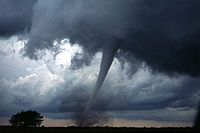
As the updraft rotates, it may form a wall cloud, a spinning layer of clouds descending from the mesocyclone. The wall cloud tends to form closer to the center of the mesocyclone. As it descends, a funnel-shaped cloud may form at its center. This is the first stage of tornado formation.
Tornado formation
The first explanation states that for tornadoes to begin to develop, two conditions must be first satisfied. One, an invisible horizontal spinning effect must be first formed upon the Earth's surface. This is usually formed by sudden changes occurred in wind direction or speed, known as wind shear
Wind shear
Wind shear, sometimes referred to as windshear or wind gradient, is a difference in wind speed and direction over a relatively short distance in the atmosphere...
. Second, a thundercloud, or occasionally a cumulus cloud, must be present. During a thunderstorm, the updrafts presented are occasionally powerful enough to lift the horizontal spinning row of air upwards, turning it into a vertical air column. This vertical air column then becomes the basic structure for the tornado. Tornadoes that form in this way are often classified as weak tornadoes and [generally] last for less than 10 minutes.
The second method of formation occurs during the occurrence of a supercell
Supercell
A supercell is a thunderstorm that is characterized by the presence of a mesocyclone: a deep, continuously-rotating updraft. For this reason, these storms are sometimes referred to as rotating thunderstorms...
thunderstorm. This type of tornado forms by the updrafts present in the supercell thunderstorm. When winds occurring during this phenomenon increase and intensify, the force released can cause the updrafts to rotate. This rotating updraft is known as a mesocyclone. For a tornado to form in this manner, a downdraft called the rear-flank downdraft enters the center of the mesocyclone from the back. Cold air, being denser than warm air is able to penetrate through the updraft. The combination of the updraft and downdraft completes the development of a tornado. Tornadoes that form in this method are often classified as violent and are capable of lasting for more than one hour.
Mesoscale convective vortex
A mesoscale convective vortexMesoscale convective vortex
A mesoscale convective vortex is a low-pressure center within an mesoscale convective system that pulls winds into a circling pattern, or vortex. With a core only 30 to wide and 1 to deep, an MCV is often overlooked in standard weather analysis. But an MCV can take on a life of its own,...
(MCV), also known as a mesoscale vorticity center or Neddy eddy, is a mesocyclone within an mesoscale convective system
Mesoscale Convective System
A mesoscale convective system is a complex of thunderstorms that becomes organized on a scale larger than the individual thunderstorms but smaller than extratropical cyclones, and normally persists for several hours or more...
(MCS) that pulls winds into a circling pattern, or vortex, at the mid levels of the troposphere
Troposphere
The troposphere is the lowest portion of Earth's atmosphere. It contains approximately 80% of the atmosphere's mass and 99% of its water vapor and aerosols....
and is normally associated with anticyclonic outflow aloft. With a core only 30 to 60 miles wide and 1 to 3 miles deep, an MCV is often overlooked in standard weather map
Weather map
A weather map displays various meteorological features across a particular area at a particular point in time. Such maps have been in use since the mid-19th century and are used for research and weather forecasting purposes. Maps using isotherms show temperature gradients, which can help locate...
s. MCVs can persist for up to 2 days after its parent mesoscale convective system has dissipated. The orphaned MCV can become the seed of the next thunderstorm outbreak. An MCV that moves into tropical waters, such as the Gulf of Mexico, can serve as the nucleus for a tropical storm or hurricane. MCVs can produce very large wind storms; sometimes winds can reach over 100 mph. The May 2009 Southern Midwest Derecho
May 2009 Southern Midwest derecho
The May 2009 Southern Midwest Derecho was an extreme progressive derecho and mesoscale convective vortex event that struck Southeastern Kansas, Southern Missouri, and Southwestern Illinois on May 8, 2009. Thirty-nine tornadoes, including two of EF3 strength on the Enhanced Fujita Scale, were...
was an extreme progressive derecho and mesoscale convective vortex event that struck Southeastern Kansas, Southern Missouri, and Southwestern Illinois on May 8, 2009.