
Maryland Route 495
Encyclopedia
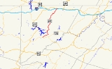
Maryland Route 495 is a state highway
in the U.S. state
of Maryland
. Known for most of its length as Bittinger Road, the state highway runs 23.02 miles (37 km) from MD 135
in Altamont
north to U.S. Route 40 Alternate (US 40 Alt) in Grantsville
. MD 495 passes through rural areas of central Garrett County
, connecting Bittinger
with the northern and southern parts of the county. The state highway also provides an alternate route to US 219
between Interstate 68
(I-68) and resorts around Deep Creek Lake
. MD 495 was constructed from both ends starting in the mid 1930s. By the late 1940s, the state highway was complete except for a 5 miles (8 km) gap south of Bittinger; this game was filled in the mid 1950s. The southern terminus of MD 495 was extended to Altamont in 1956.
, MD 495 crosses Meadow Mountain. The state highway passes Rock Lodge Road before heading through the unincorporated village of Bittinger
. Near Jennings
, MD 495 descends into the valley of the South Branch of the Casselman River
between the old alignment, Baker Road, and a brick factory. The state highway crosses the North Branch of the river at the community of Casselman and follows the Casselman River north, crossing Spiker Run and Shade Run. MD 495 leaves the river valley, ascending a hill and reaching a diamond interchange
with I-68 (National Freeway), which is concurrent with US 40
and US 219. The state highway enters the town of Grantsville, where its name is Yoder Street, and meets its northern terminus at US 40 Alternate (Main Street).
and 4 miles (6.4 km) as part of a Works Progress Administration
project—to Rock Lodge Road in Bittinger in 1940.
The first segment of highway from the south end was completed between MD 38
(now MD 135) in Altamont east to Painters School Road near Swanton by 1933. This southern segment was extended east to Swanton and north to near Upper Green Glade Road in 1935; the Altamont–Swanton segment became part of MD 135, while the section north from Swanton was designated MD 537. The southern section was extended north to North Glade Road in 1936. MD 537 was redesignated as a second section of MD 495 by 1946. The highway was extended north to Glendale Road in 1948. Three changes occurred around 1956. MD 495 was relocated between Casselman and Jennings. The gap between Glendale Road and Rock Lodge Road was closed with the completion of MD 495 over Meadow Mountain. MD 135 was moved to its present alignment atop Backbone Mountain and MD 495 was extended west from Swanton to its present southern terminus at Altamont.
.
{| class=wikitable
!Location
!Mile
!Destinations
!Notes
|-
|Altamont
|0.00
|
|Southern terminus
|-
|Swanton
|3.26
|Swanton Road east – Bloomington
|Old alignment of MD 135; MD 495 turns north onto Bittinger Road
|-
|rowspan=2|Grantsville
|22.72
|, Morgantown
|I-68 Exit 19
|-
|23.02
|
|Northern terminus
State highway
State highway, state road or state route can refer to one of three related concepts, two of them related to a state or provincial government in a country that is divided into states or provinces :#A...
in the U.S. state
U.S. state
A U.S. state is any one of the 50 federated states of the United States of America that share sovereignty with the federal government. Because of this shared sovereignty, an American is a citizen both of the federal entity and of his or her state of domicile. Four states use the official title of...
of Maryland
Maryland
Maryland is a U.S. state located in the Mid Atlantic region of the United States, bordering Virginia, West Virginia, and the District of Columbia to its south and west; Pennsylvania to its north; and Delaware to its east...
. Known for most of its length as Bittinger Road, the state highway runs 23.02 miles (37 km) from MD 135
Maryland Route 135
Maryland Route 135 is a state highway in the U.S. state of Maryland. Known for most of its length as Maryland Highway, the state highway runs from U.S. Route 219 in Oakland in Garrett County east to US 220 in McCoole in Allegany County...
in Altamont
Altamont, Maryland
Altamont is an unincorporated community in Garrett County, Maryland, United States. Altamont sits on the Eastern Continental Divide between the watershed of Crabtree Creek, which flows into the Savage River and eventually into the Atlantic Ocean, and the watershed of the Little Youghiogheny River,...
north to U.S. Route 40 Alternate (US 40 Alt) in Grantsville
Grantsville, Maryland
Grantsville is a town in Garrett County, Maryland, United States. The population was 619 at the 2000 census.-History:Grantsville, 1/2 mile west of the Casselman River, began as a small Amish and Mennonite settlement, called Tomlinson's or Little Crossing, along Braddock rd., which wound westward...
. MD 495 passes through rural areas of central Garrett County
Garrett County, Maryland
Garrett County is the westernmost county of the U.S. state of Maryland. Created from Allegany County, Maryland in 1872 it was the last Maryland county to be formed. It was named for John Work Garrett , railroad executive, industrialist, and financier. Garrett served as president of the Baltimore...
, connecting Bittinger
Bittinger, Maryland
Bittinger is an unincorporated community in northeastern Garrett County, Maryland, United States, on the western edge of the Savage River State Forest. It lies along Maryland Route 495 northeast of the city of Oakland, the county seat of Garrett County. Its elevation is 2,690 feet . ...
with the northern and southern parts of the county. The state highway also provides an alternate route to US 219
U.S. Route 219 in Maryland
U.S. Route 219 is a part of the U.S. Highway System that runs from Rich Creek, Virginia to West Seneca, New York. In the U.S. state of Maryland, the federal highway runs from the West Virginia state line near Red House to the Pennsylvania state line near Grantsville...
between Interstate 68
Interstate 68
Interstate 68 is a Interstate highway in the U.S. states of West Virginia and Maryland, connecting in Morgantown to in Hancock. is also Corridor E of the Appalachian Development Highway System. From 1965 until the freeway's construction was completed in 1991, it was designated as...
(I-68) and resorts around Deep Creek Lake
Deep Creek Lake
Deep Creek Lake is the largest inland body of water in the state of Maryland. It covers approximately and has of shoreline. Like all lakes in Maryland, it is man-made. The lake is home to a wide variety of freshwater fish and aquatic birds. The Wisp ski resort is located nearby...
. MD 495 was constructed from both ends starting in the mid 1930s. By the late 1940s, the state highway was complete except for a 5 miles (8 km) gap south of Bittinger; this game was filled in the mid 1950s. The southern terminus of MD 495 was extended to Altamont in 1956.
Route description
MD 495 begins at an intersection with MD 135 (Maryland Highway) in Altamont. The state highway heads northeast as two-lane Swanton Road through the valley of the North Branch of Crabtree Creek. MD 495 crosses the creek a few times before the highway enters the village of Swanton. At the intersection with Swanton Road, the state highway turns north onto Bittinger Road, crosses the creek for the last time, and leaves Swanton. MD 495 crosses Hickory Ridge and enters the watershed of Deep Creek Lake. The state highway crosses several streams that flow into the lake, including Green Glade Run and North Glade Run, and intersects several roads that serve the east side of the lake, including Glendale Road, which heads west to US 219 at Thayerville. After New Germany Road splits to the northeast toward New Germany State ParkNew Germany State Park
New Germany State Park is a Maryland state park contained within Savage River State Forest. The park features boat launch, boat rental, cabins, cross country skiing, camp fire programs, camp sites, snack bar, dump station, fishing, flat water canoeing, hiking trail, historic interest, picnic table...
, MD 495 crosses Meadow Mountain. The state highway passes Rock Lodge Road before heading through the unincorporated village of Bittinger
Bittinger, Maryland
Bittinger is an unincorporated community in northeastern Garrett County, Maryland, United States, on the western edge of the Savage River State Forest. It lies along Maryland Route 495 northeast of the city of Oakland, the county seat of Garrett County. Its elevation is 2,690 feet . ...
. Near Jennings
Jennings, Garrett County, Maryland
Jennings is an unincorporated community in Garrett County, Maryland, United States....
, MD 495 descends into the valley of the South Branch of the Casselman River
Casselman River
The Casselman River is a tributary of the Youghiogheny River in western Maryland and Pennsylvania in the United States.The Casselman River rises atop the plateau of western Maryland and then follows a great arc across the Laurel Highlands of Somerset County, Pennsylvania to the appropriately named...
between the old alignment, Baker Road, and a brick factory. The state highway crosses the North Branch of the river at the community of Casselman and follows the Casselman River north, crossing Spiker Run and Shade Run. MD 495 leaves the river valley, ascending a hill and reaching a diamond interchange
Diamond interchange
A diamond interchange is a common type of road junction, used where a freeway crosses a minor road. The freeway itself is grade-separated from the minor road, one crossing the other over a bridge...
with I-68 (National Freeway), which is concurrent with US 40
U.S. Route 40 in Maryland
U.S. Route 40 in the U.S. state of Maryland runs from western Maryland to Cecil County in the state's northeastern corner. With a total length of over , it is the longest numbered highway in Maryland. Almost half of the road overlaps with Interstate 68 or Interstate 70, while the old alignment...
and US 219. The state highway enters the town of Grantsville, where its name is Yoder Street, and meets its northern terminus at US 40 Alternate (Main Street).
History
The first section of MD 495 was constructed for 2.6 miles (4.2 km) between US 40 in Grantsville and Fire Clay Road in Casselman in 1933. The state highway was extended south 1.1 miles (1.8 km) to Jennings Road near Jennings in 1938. MD 495 was extended south in two sections—1.6 miles (2.6 km) by the Maryland State Roads CommissionMaryland State Highway Administration
The Maryland State Highway Administration is the state agency responsible for maintaining Maryland numbered highways outside of Baltimore City...
and 4 miles (6.4 km) as part of a Works Progress Administration
Works Progress Administration
The Works Progress Administration was the largest and most ambitious New Deal agency, employing millions of unskilled workers to carry out public works projects, including the construction of public buildings and roads, and operated large arts, drama, media, and literacy projects...
project—to Rock Lodge Road in Bittinger in 1940.
The first segment of highway from the south end was completed between MD 38
Maryland Route 38
Maryland Route 38 is a state highway in the U.S. state of Maryland. Known as Kitzmiller Road, the state highway runs from the West Virginia state line at the Potomac River in Kitzmiller, where the highway continues south as West Virginia Route 42 , north to MD 135 on top of Backbone Mountain...
(now MD 135) in Altamont east to Painters School Road near Swanton by 1933. This southern segment was extended east to Swanton and north to near Upper Green Glade Road in 1935; the Altamont–Swanton segment became part of MD 135, while the section north from Swanton was designated MD 537. The southern section was extended north to North Glade Road in 1936. MD 537 was redesignated as a second section of MD 495 by 1946. The highway was extended north to Glendale Road in 1948. Three changes occurred around 1956. MD 495 was relocated between Casselman and Jennings. The gap between Glendale Road and Rock Lodge Road was closed with the completion of MD 495 over Meadow Mountain. MD 135 was moved to its present alignment atop Backbone Mountain and MD 495 was extended west from Swanton to its present southern terminus at Altamont.
Junction list
The entire route is in Garrett CountyGarrett County, Maryland
Garrett County is the westernmost county of the U.S. state of Maryland. Created from Allegany County, Maryland in 1872 it was the last Maryland county to be formed. It was named for John Work Garrett , railroad executive, industrialist, and financier. Garrett served as president of the Baltimore...
.
{| class=wikitable
!Location
!Mile
!Destinations
!Notes
|-
|Altamont
Altamont, Maryland
Altamont is an unincorporated community in Garrett County, Maryland, United States. Altamont sits on the Eastern Continental Divide between the watershed of Crabtree Creek, which flows into the Savage River and eventually into the Atlantic Ocean, and the watershed of the Little Youghiogheny River,...
|0.00
|
|Southern terminus
|-
|Swanton
Swanton, Maryland
Swanton is an unincorporated town in Garrett County, Maryland. Swanton is close to several recreation areas like Deep Creek Lake State Park.Anderson Chapel was listed on the National Register of Historic Places in 1984.-Demographics:...
|3.26
|Swanton Road east – Bloomington
Bloomington, Maryland
Bloomington is an unincorporated town at the confluence of the North Branch Potomac River and Savage River in southeastern Garrett County, Maryland...
|Old alignment of MD 135; MD 495 turns north onto Bittinger Road
|-
|rowspan=2|Grantsville
Grantsville, Maryland
Grantsville is a town in Garrett County, Maryland, United States. The population was 619 at the 2000 census.-History:Grantsville, 1/2 mile west of the Casselman River, began as a small Amish and Mennonite settlement, called Tomlinson's or Little Crossing, along Braddock rd., which wound westward...
|22.72
|, Morgantown
Morgantown, West Virginia
Morgantown is a city in Monongalia County, West Virginia. It is the county seat of Monongalia County. Placed along the banks of the Monongahela River, Morgantown is the largest city in North-Central West Virginia, and the base of the Morgantown metropolitan area...
|I-68 Exit 19
|-
|23.02
|
|Northern terminus