

Timeline of the 1995 Atlantic hurricane season
Encyclopedia
Landfall (meteorology)
Landfall is the event of a tropical cyclone or a waterspout coming onto land after being over water. When a waterspout makes landfall it is reclassified as a tornado, which can then cause damage inland...
, extratropical transitions, as well as dissipation during the 1995 Atlantic hurricane season
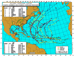
1995 Atlantic hurricane season
The 1995 Atlantic hurricane season was the third most active Atlantic hurricane season on record. It officially began on June 1, 1995, and lasted until November 30, 1995. These dates conventionally delimit the period of each year when most tropical cyclones form in the north Atlantic ocean...
. The season officially began on June 1, 1995, and ended on November 30, and no storms formed off-season. The timeline includes information which was not operationally released, meaning that information from post-storm reviews by the National Hurricane Center
National Hurricane Center
The National Hurricane Center , located at Florida International University in Miami, Florida, is the division of the National Weather Service responsible for tracking and predicting weather systems within the tropics between the Prime Meridian and the 140th meridian west poleward to the 30th...
, such as information on a storm that was not operationally warned on, have been included.
Hurricane Allison was the first storm of the season to form on June 2. The storm affected Cuba as a tropical storm, and later affected the United States before dissipating. Hurricane Luis formed on August 27. Hurricane Luis would eventually strike the Leeward Islands
Leeward Islands
The Leeward Islands are a group of islands in the West Indies. They are the northern islands of the Lesser Antilles chain. As a group they start east of Puerto Rico and reach southward to Dominica. They are situated where the northeastern Caribbean Sea meets the western Atlantic Ocean...
; Sint Maarten/Saint Martin
Saint Martin
Saint Martin is an island in the northeast Caribbean, approximately east of Puerto Rico. The 87 km2 island is divided roughly 60/40 between France and the Kingdom of the Netherlands ; however, the Dutch side has the larger population. It is one of the smallest sea islands divided between...
was particularly affected. Only 5% of the boats that took shelter in the lagoon in the island were not sunk or thrown ashore. Luis caused over $2.5 billion in damage.
During the year, a total of 21 tropical depressions, 19 tropical storms, 11 hurricanes and four major hurricanes formed. The most intense hurricane, Opal
Hurricane Opal
Hurricane Opal was a Category 4 hurricane that formed in the Gulf of Mexico in September 1995.Opal was the ninth hurricane and the strongest of the abnormally active 1995 Atlantic hurricane season...
, has the lowest pressure for a category 4 hurricane that did not reach category 5 status. Even though the season is the second most active hurricane season since naming of hurricanes began in 1950
1950 Atlantic hurricane season
The 1950 Atlantic hurricane season was the first year in which tropical cyclones were given official names in the Atlantic basin. Names were taken from the Joint Army/Navy Phonetic Alphabet, with the first named storm being designated "Able", the second "Baker", and so on. It was an active season...
, there were no category 5 hurricanes.
June

- The 1995 Atlantic hurricane season1995 Atlantic hurricane seasonThe 1995 Atlantic hurricane season was the third most active Atlantic hurricane season on record. It officially began on June 1, 1995, and lasted until November 30, 1995. These dates conventionally delimit the period of each year when most tropical cyclones form in the north Atlantic ocean...
begins.
June 3
- 0000 UTC (8:00 p.m. EDT June 2) – Tropical Depression One forms 230 miles (370 km) east of Belize City, Belize.
- 1200 UTC (7:00 a.m. CDT) – Tropical Depression One strengthens into a tropical storm and is named Allison.
June 4
- 1200 UTC (7:00 a.m. CDT) – Tropical Storm Allison strengthens into the first hurricane of the season and reaches its peak intensity of 75 mph (120 km/h).
June 5
- 0600 UTC (1:00 a.m. CDT) – Hurricane Allison weakens into a tropical storm.
- 1400 UTC (10:00 a.m. EDT) – Tropical Storm Allison makes landfall near Alligator Point, Florida, United StatesAlligator Point, FloridaAlligator Point is an unincorporated community in Franklin County, Florida, United States. It is located along US 98, south of Bald Point State Park. , on the Gulf of Mexico. Alligator Point is a small beach community made up of mostly beach homes and the...
with winds of 70 mph (110 km/h). - 1500 UTC (11:00 a.m. EDT) – Tropical Storm Allison makes landfall near Saint Marks, Florida, United States with winds of 65 mph (105 km/h).
June 6
- 0000 UTC (7:00 a.m. EDT June 5) – Tropical Storm Allison weakens into a tropical depression.
- 0600 UTC (1:00 a.m. EDT) – Tropical Depression Allison becomes extratropical over southern Georgia, United States.
July
- 1800 UTC (2:00 p.m. EDT) – Tropical Depression Two forms 300 miles (480 km) west of Cape Hatteras, North Carolina, United StatesCape HatterasCape Hatteras is a cape on the coast of North Carolina. It is the point that protrudes the farthest to the southeast along the northeast-to-southwest line of the Atlantic coast of North America...
.
July 7
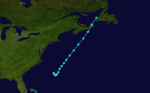
- 0600 UTC (2:00 a.m. EDT) – Tropical Depression Two strengthens into a tropical storm and is named Barry.
- 1800 UTC (2:00 p.m. EDT) – Tropical Storm Barry reaches its peak intensity of 70 mph (110 km/h).
July 9
- 2130 UTC (5:30 p.m. EDT) – Tropical Storm Barry makes landfall on Hart Island, Nova Scotia, Canada with winds of 60 mph (95 km/h).
- 2200 UTC (6:00 p.m. EDT) – Tropical Storm Barry makes landfall on Cape Breton Island, Nova Scotia, Canada with winds of 50 mph (80 km/h).
July 10
- 0600 UTC (2:00 a.m. EDT) – Tropical Storm Barry becomes extratropical 445 miles (715 km) northwest of Eastport, Maine, United StatesEastport, MaineEastport is a small city in Washington County, Maine, United States. The population was 1,640 at the 2000 census. The principal island is Moose Island, which is connected to the mainland by causeway...
.
July 12
- 0000 UTC (8:00 p.m. EDT July 11) – Tropical Depression Three forms 440 miles (710 km) west of Guadelope.
July 14
- 0000 UTC (8:00 p.m. EDT July 13) – Tropical Depression Three strengthens into a tropical storm and is named Chantal.
July 17
- 0000 UTC (8:00 p.m. EDT July 16) – Tropical Storm Chantal reaches its peak intensity of 70 mph (110 km/h).
July 20
- 1800 UTC (2:00 p.m. EDT) – Tropical Storm Chantal becomes extratropical 1965 miles (3160 km) east of Dublin, Ireland.
July 28
- 1800 UTC (1:00 p.m. CDT) – Tropical Depression Four forms 300 miles (480 km) southeast of New Orleans, Louisiana, United States.
July 30
- 1800 UTC (1:00 p.m. CDT) – Tropical Depression Four strengthens into a tropical storm and is named Dean.
July 31
- 0000 UTC (7:00 p.m. CDT July 30) – Tropical Storm Dean reaches its peak intensity of 45 mph (70 km/h).
- 0000 UTC - Tropical Storm Erin forms over the Bahamas.
- 0200 UTC (9:00 p.m. CDT July 30) – Tropical Storm Dean makes landfall near Freeport, Texas, United StatesFreeport, TexasFreeport is a city in Brazoria County, Texas within the Houston–Sugar Land–Baytown metropolitan area and is situated in Southeast Texas. As of the 2000 U.S...
with winds of 40 mph (70 km/h). - 0600 UTC (1:00 a.m. CDT) – Tropical Storm Dean weakens into a tropical depression.
August

- 0000 UTC - Tropical Storm Erin becomes a hurricane.
August 2
- 0615 UTC - Hurricane Erin makes landfall on Vero Beach, FloridaVero Beach, FloridaVero Beach is a city in Indian River County, Florida, USA. According to the U.S. Census Bureau's 2006 estimates, the city had a population of 16,939. It is the county seat of Indian River County...
with winds of 85 miles per hour. - 1200 UTC - Hurricane Erin weakens into a tropical storm.
August 3
- 0000 UTC - Tropical Storm Erin regains hurricane strength.
- 0000 UTC (7:00 p.m. CDT August 2) – Tropical Depression Dean dissipates over northern Texas, United StatesTexasTexas is the second largest U.S. state by both area and population, and the largest state by area in the contiguous United States.The name, based on the Caddo word "Tejas" meaning "friends" or "allies", was applied by the Spanish to the Caddo themselves and to the region of their settlement in...
. - 1330 UTC - Hurricane Erin becomes a category 2 hurricane and makes landfall near Fort Walton Beach, FloridaFort Walton Beach, FloridaFort Walton Beach is a city in southern Okaloosa County, Florida, United States. As of 2005, the population estimate for Fort Walton Beach was 19,992, and as of 2010, the population estimate for Fort Walton Beach is 19,507 recorded by the U.S. Census Bureau...
with winds of 100 miles per hour. - 1600 UTC - Hurricane Erin weakens to a category 1 hurricane and makes landfall near Pensacola Beach, FloridaPensacola Beach, FloridaPensacola Beach is an unincorporated community located on Santa Rosa Island, a barrier island, in Escambia County, Florida, United States. It is situated south of Pensacola, and Gulf Breeze connected via bridges spanning to the Fairpoint Peninsula and then to the island, on the Gulf of Mexico...
with winds of 85 miles per hour.
August 4
- 0000 UTC - Hurricane Erin weakens into a tropical storm.
- 1200 UTC - Tropical Storm Erin weakens into a tropical depression.
August 5
- 1800 UTC - Tropical Depression Six forms from the southern part of the low that became Hurricane ErinHurricane Erin (1995)Hurricane Erin was the fifth named tropical cyclone and the second hurricane of the unusually active 1995 Atlantic hurricane season. Erin began as a tropical wave off the west coast of Africa on July 22, and crossed the Atlantic ocean without ever developing. On July 31, the last day of the month,...
.
August 6
- 1200 UTC - Tropical Depression Erin merges with a front.
- 2300 UTC - Tropical Depression Six makes landfall near Cabo Rojo, Mexico with winds of 35 miles per hour.
August 7
- 1800 UTC - Tropical Depression Six dissipates over MexicoMexicoThe United Mexican States , commonly known as Mexico , is a federal constitutional republic in North America. It is bordered on the north by the United States; on the south and west by the Pacific Ocean; on the southeast by Guatemala, Belize, and the Caribbean Sea; and on the east by the Gulf of...
.
August 8
- 0000 UTC - Tropical Depression Seven forms southwest of the Cape Verde Islands.
- 1800 UTC - Tropical Depression Seven strengthens into Tropical Storm Felix.

- 1800 UTC - Tropical Depression Eight forms in the western Gulf of MexicoGulf of MexicoThe Gulf of Mexico is a partially landlocked ocean basin largely surrounded by the North American continent and the island of Cuba. It is bounded on the northeast, north and northwest by the Gulf Coast of the United States, on the southwest and south by Mexico, and on the southeast by Cuba. In...
.
August 10
- 1200 UTC - Tropical Depression Eight strengthens into Tropical Storm Gabrielle.
August 11
- 0000 UTC - Tropical Storm Felix reaches hurricane strength.
- 1800 UTC - Hurricane Felix reaches category 2 strength.
- 2000 UTC - Tropical Storm Gabrielle makes landfall south of La Pesca, Mexico with winds of 70 miles per hour.

- 0000 UTC - Hurricane Felix becomes the season's first major hurricane.
- 0000 UTC - Tropical Storm Gabrielle rapidly dissipates over the mountains of MexicoMexicoThe United Mexican States , commonly known as Mexico , is a federal constitutional republic in North America. It is bordered on the north by the United States; on the south and west by the Pacific Ocean; on the southeast by Guatemala, Belize, and the Caribbean Sea; and on the east by the Gulf of...
. - 1200 UTC - Hurricane Felix reaches category 4 strength.
August 13
- 0600 UTC - Hurricane Felix weakens into a category 3 hurricane.
- 1800 UTC - Hurricane Felix weakens into a category 2 hurricane.
August 14
- 0600 UTC - Hurricane Felix weakens into a category 1 hurricane.
August 20
- 0600 UTC - Hurricane Felix weakens into a tropical storm.
August 22
- 0000 UTC - Tropical Depression Nine forms.
- 0600 UTC - Tropical Depression Nine strengthens into Tropical Storm Humberto.
- 1200 UTC - Tropical Depression Ten forms east of Tropical Depression Nine.
- 1800 UTC - Tropical Depression Ten strengthens into Tropical Storm Iris.
- 1800 UTC - Tropical Depression Eleven forms.
- 1800 UTC - Tropical Storm Felix becomes extratropical.
August 23
- 0600 UTC - Tropical Storm Humberto strengthens into a hurricane.
- 1200 UTC - Tropical Depression Eleven strengthens into Tropical Storm Jerry.
- 1800 UTC - Tropical Storm Iris strengthens into a hurricane.
- 1800 UTC - Tropical Storm Jerry makes landfall near Jupiter, FloridaJupiter, FloridaJupiter is a town located in Palm Beach County, Florida. As of the 2000 census, the town had a total population of 39,328. The estimate population for 2009 is 50,606. As of 2006, the population had grown to 50,028, according to the University of Florida, Bureau of Economic and Business Research....
with winds of 35 miles per hour.
- 0600 UTC - Hurricane Humberto reaches category 2 strength.
- 1200 UTC - Tropical Storm Jerry weakens into a tropical depression.
- 1800 UTC - Hurricane Iris weakens into a tropical storm.
August 26
During the Day, Tropical Storm Iris makes direct hits, but no landfalls on some Caribbean Islands.
- 1200 UTC - Tropical Depression Twelve forms.
- 1800 UTC - Hurricane Humberto weakens into a category 1 hurricane.
August 27
- 1200 UTC - Tropical Depression Thirteen forms.
- 1800 UTC - Tropical Storm Iris makes its first landfall on Montserrat, Antigua with winds of 60 miles per hour.
- 2300 UTC - Tropical Storm Iris makes its second, and last landfall on BarbudaBarbudaBarbuda is an island in the Eastern Caribbean, and forms part of the state of Antigua and Barbuda. It has a population of about 1,500, most of whom live in the town of Codrington.-Location:...
with wind of 65 miles per hour.
August 28
- 0600 UTC - Tropical Depression Twelve strengthens into Tropical Storm Karen.
- 0600 UTC - Tropical Depression Jerry is absorbed by a trough.
- 1800 UTC - Tropical Storm Iris regains hurricane strength.
August 29
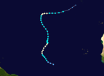
- 0000 UTC - Tropical Depression Thirteen strengthens into Tropical Storm Luis.
August 30
- 1800 UTC - Tropical Storm Luis becomes a hurricane.
August 31
- 1200 UTC - Hurricane Luis strengthens into a category 2 hurricane.
- 1800 UTC - Hurricane Iris strengthens into a category 2 hurricane.
- 1800 UTC - Hurricane Humberto weakens into a tropical storm.
September

- 0000 UTC - Hurricane Luis becomes a major hurricane.
- 0600 UTC - Tropical Storm Humberto is absorbed by an extratropical cyclone in the north Atlantic.
- 1200 UTC - Hurricane Luis becomes a category 4 hurricane.
September 2
- 1200 UTC - Hurricane Iris weakens into a category 1 hurricane.
- 1200 UTC - Tropical Storm Karen weakens into a tropical depression.
September 3
- 0600 UTC - Tropical Depression Karen is absorbed by Tropical Storm Iris.
September 4
- 0600 UTC - Hurricane Iris weakens into a tropical storm.
- 1200 UTC - Tropical Storm Iris becomes extratropical.
September 7
- 1200 UTC - Hurricane Luis weakens into a category 3 hurricane.
September 9
- 0000 UTC - Hurricane Luis weakens into a category 2 hurricane.
- 1200 UTC - Tropical Depression Fourteen forms.
September 10
- 1200 UTC - Hurricane Luis weakens into a category 1 hurricane.
September 11
- 1200 UTC - Hurricane Luis becomes extratropical.
- 1800 UTC - Tropical Depression Fifteen forms.
September 13
- 0000 UTC - Tropical Depression Fifteen strengthens into Tropical Storm Marilyn.
- 1800 UTC - Tropical Depression Fourteen dissipates.
September 14
- 0000 UTC - Tropical Storm Marilyn strengthens into a hurricane.
September 15
- 1800 UTC - Hurricane Marilyn strengthens into a category 2 hurricane.
September 16
- 1800 UTC - Hurricane Marilyn strengthens into a major hurricane.

- 0600 UTC - Hurricane Marilyn weakens into a category 2 hurricane.
September 18
- 1800 UTC - Hurricane Marilyn weakens into a category 1 hurricane.
September 21
- 1800 UTC - Hurricane Marilyn weakens into a tropical storm.
September 22
- 0600 UTC - Tropical Storm Marilyn becomes extratropical.
September 26
- 1800 UTC - Tropical Depression Sixteen forms
- 1200 UTC - Tropical Depression Sixteen strengthens into Tropical Storm Noel.
- 1800 UTC - Tropical Depression Seventeen forms in the Gulf of MexicoGulf of MexicoThe Gulf of Mexico is a partially landlocked ocean basin largely surrounded by the North American continent and the island of Cuba. It is bounded on the northeast, north and northwest by the Gulf Coast of the United States, on the southwest and south by Mexico, and on the southeast by Cuba. In...
September 29
- 1800 UTC - Tropical Storm Noel strengthens into a hurricane.
September 30
- 1200 UTC - Tropical Depression Seventeen strengthens into Tropical Storm Opal.
- 1200 UTC - Hurricane Noel weakens into a tropical storm.
October
October 2- 1200 UTC - Tropical Storm Opal becomes a hurricane.
October 3
- 1800 UTC - Hurricane Opal strengthens into a category 2 hurricane.
October 4
- 0000 UTC - Hurricane Opal becomes a major hurricane.
- 1200 UTC - Hurricane Opal strengthens into a Category 4 hurricane and reaches its peak intensity with winds of 150 mph (240 km/h) and a minimum pressure of 916 mbarBar (unit)The bar is a unit of pressure equal to 100 kilopascals, and roughly equal to the atmospheric pressure on Earth at sea level. Other units derived from the bar are the megabar , kilobar , decibar , centibar , and millibar...
(hPaPascal (unit)The pascal is the SI derived unit of pressure, internal pressure, stress, Young's modulus and tensile strength, named after the French mathematician, physicist, inventor, writer, and philosopher Blaise Pascal. It is a measure of force per unit area, defined as one newton per square metre...
; 27.06 inHg), making it both the strongest storm of the season and, at the time, the strongest Category 4, in terms of pressure, on record. - 1800 UTC - Tropical Depression Eighteen forms.
- 1800 UTC - Hurricane Opal weakens into a category 3 hurricane.
- 2200 UTC - Hurricane Opal makes landfall at Pensacola Beach, FloridaPensacola Beach, FloridaPensacola Beach is an unincorporated community located on Santa Rosa Island, a barrier island, in Escambia County, Florida, United States. It is situated south of Pensacola, and Gulf Breeze connected via bridges spanning to the Fairpoint Peninsula and then to the island, on the Gulf of Mexico...
with winds of 115 miles per hour.

- 0000 UTC - Tropical Storm Noel re-strengthens into a hurricane.
- 0000 UTC - Hurricane Opal weakens quickly to category 1 strength.
- 0600 UTC - Hurricane Opal weakens into a tropical storm.
- 1200 UTC - Tropical Depression Eighteen strengthens into Tropical Storm Pablo.
- 1200 UTC - Tropical Storm Opal weakens into a tropical depression.
- 1800 UTC - Tropical Depression Opal becomes extratropical.
October 6
- 0000 UTC - Hurricane Noel again loses hurricane status.
October 7
- 0600 UTC - Tropical Storm Noel becomes extratropical.
- 1800 UTC - Tropical Depression Nineteen forms.
October 8
- 1200 UTC - Tropical Storm Pablo weakens into a tropical depression due to wind shear.
- 1800 UTC - Tropical Depression Pablo dissipates.
October 9
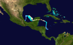
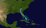
- 0000 UTC - Tropical Depression Nineteen strengthens into Tropical Storm Roxanne.
October 10
- 0600 UTC - Tropical Storm Roxanne strengthens into Hurricane Roxanne.
- 1800 UTC - Hurricane Roxanne reaches category 2 strength.
October 11
- 0000 UTC - Hurricane Roxanne becomes the final major hurricane of the season.
- 0200 UTC - Hurricane Roxanne makes landfall near Tolum, Mexico with winds of 115 miles per hour.
- 0600 UTC - Hurricane Roxanne weakens into a category 2 hurricane.
- 1200 UTC - Hurricane Roxanne weakens into a category 1 hurricane.
October 12
- 1200 UTC - Hurricane Roxanne weakens into a tropical storm.
October 14
- 1200 UTC - Tropical Storm Roxanne re-strengthens into a hurricane.
October 17
- 0600 UTC - Hurricane Roxanne again loses hurricane strength.
October 19
- 0000 UTC - Tropical Storm Roxanne weakens into a tropical depression.
October 20
.jpg)
- 1200 UTC - Tropical Depression Twenty forms.
October 21
- 0000 UTC - Tropical Depression Twenty strengthens into Tropical Storm Sebastien.
- 0000 UTC - Tropical Depression Roxanne dissipates.
October 24
- 0000 UTC - Tropical Storm Sebastien weakens into a tropical depression.
October 24
- 0000 UTC - Tropical Depression Sebastien dissipates.
October 27
- 0000 UTC - A tropical depression forms.
- 1200 UTC - The tropical depression strengthens into Tropical Storm Tanya.
October 29
- 1200 UTC - Tropical Storm Tanya becomes the season's final hurricane.
November
November 1- 1200 UTC - Hurricane Tanya weakens into a tropical storm.
November 2
- 0000 UTC - Tropical Storm Tanya becomes extratropical.
November 30
- The 1995 Atlantic hurricane season officially ends.
See also
- 1995 Atlantic hurricane season1995 Atlantic hurricane seasonThe 1995 Atlantic hurricane season was the third most active Atlantic hurricane season on record. It officially began on June 1, 1995, and lasted until November 30, 1995. These dates conventionally delimit the period of each year when most tropical cyclones form in the north Atlantic ocean...
- List of Atlantic hurricanes
- List of United States hurricanes
- List of wettest tropical cyclones by country