
Maryland Route 425
Encyclopedia
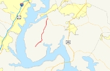
Maryland Route 425 is a state highway
in the U.S. state
of Maryland
. The state highway runs 11.77 miles (18.9 km) from MD 6
near Nanjemoy
north to MD 224
in Mason Springs. MD 425 connects Nanjemoy and Ironsides
with Pisgah
and Mason Springs in western Charles County
. The state highway was built as two different routes in the early 1930s: MD 425 from Mason Springs to south of Pisgah, and MD 491 near Nanjemoy. MD 425 and MD 491 were extended to MD 6 in Ironsides in 1950, with MD 425 assuming MD 491 in 1956.
. At Durham Church Road, MD 425 makes a 90-degree turn to the north and intersects MD 6 again in the village of Ironsides. The state highway continues north as Mason Springs Road, crossing Jane Berrys Run. MD 425 intersects Bicknell Road and Poorhouse Road in the hamlet of Pisgah and passes the historic home Araby
before reaching the highway's northern terminus at MD 224 (Chicamuxen Road) in Mason Springs.
.
{| class=wikitable
!Location
!Mile
!Destinations
!Notes
|-
|Nanjemoy
|0.00
|
|Southern terminus
|-
|Ironsides
|4.81
|
|
|-
|Pisgah
|8.66
|Bicknell Road west / Poorhouse Road east – Marbury
, Port Tobacco
|Former MD 484
|-
|Mason Springs
|11.77
|
|Northern terminus
State highway
State highway, state road or state route can refer to one of three related concepts, two of them related to a state or provincial government in a country that is divided into states or provinces :#A...
in the U.S. state
U.S. state
A U.S. state is any one of the 50 federated states of the United States of America that share sovereignty with the federal government. Because of this shared sovereignty, an American is a citizen both of the federal entity and of his or her state of domicile. Four states use the official title of...
of Maryland
Maryland
Maryland is a U.S. state located in the Mid Atlantic region of the United States, bordering Virginia, West Virginia, and the District of Columbia to its south and west; Pennsylvania to its north; and Delaware to its east...
. The state highway runs 11.77 miles (18.9 km) from MD 6
Maryland Route 6
Maryland Route 6 is a state highway in the U.S. state of Maryland. The state highway runs from a dead end at the Potomac River in Riverside east to MD 235 in Oraville. MD 6 connects several small communities in southern Charles County and northern St. Mary's County with U.S. Route 301 in La...
near Nanjemoy
Nanjemoy, Maryland
Nanjemoy is a settlement along Maryland Route 6 in southwestern Charles County, Maryland, United States, and the surrounding large rural area more or less bounded by Nanjemoy Creek to the east and north, and the Potomac River to the south and west. It and the creek draw their names from a Native...
north to MD 224
Maryland Route 224
Maryland Route 224 is a state highway in the U.S. state of Maryland. The state highway runs from MD 6 in Riverside north to MD 227 in Pomonkey. MD 224 is one of the main highways of southwestern Charles County, connecting several villages, state parks, and preserves along the Potomac River and...
in Mason Springs. MD 425 connects Nanjemoy and Ironsides
Ironsides, Maryland
Ironsides is an unincorporated community or "post village" in Charles County, Maryland, United States with zip code 20643. The Post Office was established in 1897 and remained open until at least 1976. Today Ironsides area residents have Indian Head or Nanjemoy addresses...
with Pisgah
Pisgah, Maryland
Pisgah is an unincorporated community in Charles County, Maryland, United States....
and Mason Springs in western Charles County
Charles County, Maryland
Charles County is a county in the south central portion of the U.S. state of Maryland.As of 2010, the population was 146,551. Its county seat is La Plata. This county was named for Charles Calvert , third Baron Baltimore....
. The state highway was built as two different routes in the early 1930s: MD 425 from Mason Springs to south of Pisgah, and MD 491 near Nanjemoy. MD 425 and MD 491 were extended to MD 6 in Ironsides in 1950, with MD 425 assuming MD 491 in 1956.
Route description
MD 425 begins at an intersection with MD 6 (Port Tobacco Road) south of the community of Nanjemoy and north of the hamlet of Grayton. The state highway heads northeast as two-lane Ironsides Road through a forested area, passing Baptist Church Road and crosses a branch of Hill Top Fork of Nanjemoy CreekNanjemoy Creek
Nanjemoy Creek is a tidal tributary of the Potomac River in Charles County, Maryland, USA, located between Cedar Point Neck and Tayloe Neck.The Nature Conservancy established its Nanjemoy Creek Preserve in 1978, which protects more than in the watershed...
. At Durham Church Road, MD 425 makes a 90-degree turn to the north and intersects MD 6 again in the village of Ironsides. The state highway continues north as Mason Springs Road, crossing Jane Berrys Run. MD 425 intersects Bicknell Road and Poorhouse Road in the hamlet of Pisgah and passes the historic home Araby
Araby (Mason's Springs, Maryland)
Araby is a historic home located near Mason Springs, Charles County, Maryland. It was the home of William and Sarah Eilbeck, whose daughter Anne married George Mason. George Washington recorded many visits to Araby. It is a mid-18th century house that was extensively altered in the mid 19th century...
before reaching the highway's northern terminus at MD 224 (Chicamuxen Road) in Mason Springs.
History
The first section of MD 425 was constructed as a gravel road south 2 miles (3.2 km) from Mason Springs in 1930. The highway was extended south another 2 miles (3.2 km) through Pisgah in 1933. Also in 1933, 1 miles (1.6 km) of gravel road was constructed from the Nanjemoy end. This segment was originally designated MD 491. MD 425 was extended with another 2 miles (3.2 km) section in 1934. The courses of MD 425 and MD 491 remained the same until 1950 when MD 425 was extended south to Ironsides and MD 491 was extended north to Ironsides. MD 425 was extended south to Nanjemoy, assuming MD 491's entire course, in 1956.Junction list
The entire route is in Charles CountyCharles County, Maryland
Charles County is a county in the south central portion of the U.S. state of Maryland.As of 2010, the population was 146,551. Its county seat is La Plata. This county was named for Charles Calvert , third Baron Baltimore....
.
{| class=wikitable
!Location
!Mile
!Destinations
!Notes
|-
|Nanjemoy
Nanjemoy, Maryland
Nanjemoy is a settlement along Maryland Route 6 in southwestern Charles County, Maryland, United States, and the surrounding large rural area more or less bounded by Nanjemoy Creek to the east and north, and the Potomac River to the south and west. It and the creek draw their names from a Native...
|0.00
|
|Southern terminus
|-
|Ironsides
Ironsides, Maryland
Ironsides is an unincorporated community or "post village" in Charles County, Maryland, United States with zip code 20643. The Post Office was established in 1897 and remained open until at least 1976. Today Ironsides area residents have Indian Head or Nanjemoy addresses...
|4.81
|
|
|-
|Pisgah
Pisgah, Maryland
Pisgah is an unincorporated community in Charles County, Maryland, United States....
|8.66
|Bicknell Road west / Poorhouse Road east – Marbury
Marbury, Maryland
Marbury is an unincorporated community in Charles County, Maryland. It has been designated the zip code of 20658.It is 6.3 miles from Indian Head on Maryland Route 224....
, Port Tobacco
|Former MD 484
|-
|Mason Springs
|11.77
|
|Northern terminus