
Geography of Israel
Encyclopedia
 |
|
| Relief map of Israel | |
| Area | |
| Total | 20,700 km2 |
| Water | 430 km2 |
| Latitude | 31°30' N |
| Longitude | 34°45'W |
| Borders | |
| Egypt | 266 km |
| Gaza Strip | 51 km |
| Jordan | 238 km |
| Lebanon | 79 km |
| Syria | 76 km |
| West Bank | 307 km |
| Coastlines | 273 km |
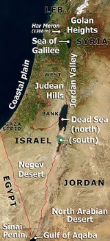
The geography of Israel is very diverse, with desert
Desert
A desert is a landscape or region that receives an extremely low amount of precipitation, less than enough to support growth of most plants. Most deserts have an average annual precipitation of less than...
conditions in the south, and snow-capped mountains in the north. Israel
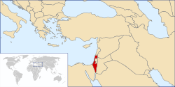
Israel
The State of Israel is a parliamentary republic located in the Middle East, along the eastern shore of the Mediterranean Sea...
is located at 31°30′N 34°45′E at the eastern end of the Mediterranean Sea
Mediterranean Sea
The Mediterranean Sea is a sea connected to the Atlantic Ocean surrounded by the Mediterranean region and almost completely enclosed by land: on the north by Anatolia and Europe, on the south by North Africa, and on the east by the Levant...
in western Asia. It is bounded to the north by Lebanon
Lebanon
Lebanon , officially the Republic of LebanonRepublic of Lebanon is the most common term used by Lebanese government agencies. The term Lebanese Republic, a literal translation of the official Arabic and French names that is not used in today's world. Arabic is the most common language spoken among...
, the northeast by Syria
Syria
Syria , officially the Syrian Arab Republic , is a country in Western Asia, bordering Lebanon and the Mediterranean Sea to the West, Turkey to the north, Iraq to the east, Jordan to the south, and Israel to the southwest....
, the east by Jordan
Jordan
Jordan , officially the Hashemite Kingdom of Jordan , Al-Mamlaka al-Urduniyya al-Hashemiyya) is a kingdom on the East Bank of the River Jordan. The country borders Saudi Arabia to the east and south-east, Iraq to the north-east, Syria to the north and the West Bank and Israel to the west, sharing...
and the West Bank
West Bank
The West Bank ) of the Jordan River is the landlocked geographical eastern part of the Palestinian territories located in Western Asia. To the west, north, and south, the West Bank shares borders with the state of Israel. To the east, across the Jordan River, lies the Hashemite Kingdom of Jordan...
, and to the southwest by Egypt
Egypt
Egypt , officially the Arab Republic of Egypt, Arabic: , is a country mainly in North Africa, with the Sinai Peninsula forming a land bridge in Southwest Asia. Egypt is thus a transcontinental country, and a major power in Africa, the Mediterranean Basin, the Middle East and the Muslim world...
, with this border also being the border between Asia and Africa. To the west of Israel is the Mediterranean Sea
Mediterranean Sea
The Mediterranean Sea is a sea connected to the Atlantic Ocean surrounded by the Mediterranean region and almost completely enclosed by land: on the north by Anatolia and Europe, on the south by North Africa, and on the east by the Levant...
, which makes up the majority of Israel's 273 kilometres (170 mi) coastline and the Gaza strip
Gaza Strip
thumb|Gaza city skylineThe Gaza Strip lies on the Eastern coast of the Mediterranean Sea. The Strip borders Egypt on the southwest and Israel on the south, east and north. It is about long, and between 6 and 12 kilometres wide, with a total area of...
. Israel has a small coastline on the Red Sea
Red Sea
The Red Sea is a seawater inlet of the Indian Ocean, lying between Africa and Asia. The connection to the ocean is in the south through the Bab el Mandeb strait and the Gulf of Aden. In the north, there is the Sinai Peninsula, the Gulf of Aqaba, and the Gulf of Suez...
in the south.
Israel's area is approximately 20700 square kilometres (7,992 sq mi), which includes 445 square kilometres (172 sq mi) of inland water. Israel stretches 424 kilometres (263 mi) from north to south, and its width ranges from 114 kilometres (71 mi) to, at its narrowest point, 15 kilometres (9.3 mi). Israel also partially controls the West Bank
West Bank
The West Bank ) of the Jordan River is the landlocked geographical eastern part of the Palestinian territories located in Western Asia. To the west, north, and south, the West Bank shares borders with the state of Israel. To the east, across the Jordan River, lies the Hashemite Kingdom of Jordan...
, 5879 square kilometres (2,270 sq mi), East Jerusalem
East Jerusalem
East Jerusalem or Eastern Jerusalem refer to the parts of Jerusalem captured and annexed by Jordan in the 1948 Arab-Israeli War and then captured and annexed by Israel in the 1967 Six-Day War...
, 70 square kilometres (27 sq mi) and the Golan Heights, 1150 square kilometres (444 sq mi). Geographical features in these territories will be noted as such.
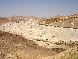
The south of Israel is dominated by the Negev
Negev
The Negev is a desert and semidesert region of southern Israel. The Arabs, including the native Bedouin population of the region, refer to the desert as al-Naqab. The origin of the word Neghebh is from the Hebrew root denoting 'dry'...
desert covering some 12000 square kilometres (4,633 sq mi), more than half of the country's total land area. The north of the Negev contains the Judean Desert
Judean desert
The Judaean Desert is a desert in Israel and the West Bank that lies east of Jerusalem and descends to the Dead Sea. It stretches from the northeastern Negev to the east of Beit El, and is marked by terraces with escarpments. It ends in a steep escarpment dropping to the Dead Sea and the Jordan...
, which, at its border with Jordan, contains the Dead Sea
Dead Sea
The Dead Sea , also called the Salt Sea, is a salt lake bordering Jordan to the east and Israel and the West Bank to the west. Its surface and shores are below sea level, the lowest elevation on the Earth's surface. The Dead Sea is deep, the deepest hypersaline lake in the world...
which, at -417 m is the lowest point on Earth. The inland area of central Israel is dominated by the Judean Hills of the West Bank, whilst the central and northern coastline consists of the flat and fertile Israeli coastal plain
Israeli Coastal Plain
The Israeli coastal plain is the narrow coastal plain along Israel's Mediterranean Sea coast which houses 70% of the country's population. The plain extends north to south and is divided into a number of areas; the Plain of Zebulun , Hof HaCarmel , the Sharon plain , and the Plain of Judea The...
. Inland, the northern region contains the Mount Carmel
Mount Carmel
Mount Carmel ; , Kármēlos; , Kurmul or جبل مار إلياس Jabal Mar Elyas 'Mount Saint Elias') is a coastal mountain range in northern Israel stretching from the Mediterranean Sea towards the southeast. Archaeologists have discovered ancient wine and oil presses at various locations on Mt. Carmel...
mountain range, which is followed inland by the fertile Jezreel Valley
Jezreel Valley
-Etymology:The Jezreel Valley takes its name from the ancient city of Jezreel which was located on a low hill overlooking the southern edge of the valley, though some scholars think that the name of the city originates from the name of the clan which founded it, and whose existence is mentioned in...
, and then the hilly Galilee
Galilee
Galilee , is a large region in northern Israel which overlaps with much of the administrative North District of the country. Traditionally divided into Upper Galilee , Lower Galilee , and Western Galilee , extending from Dan to the north, at the base of Mount Hermon, along Mount Lebanon to the...
region. The Sea of Galilee
Sea of Galilee
The Sea of Galilee, also Kinneret, Lake of Gennesaret, or Lake Tiberias , is the largest freshwater lake in Israel, and it is approximately in circumference, about long, and wide. The lake has a total area of , and a maximum depth of approximately 43 m...
is located beyond this, and is bordered to the east by the Golan Heights, which contains the highest point under Israel's control, a peak in the Mount Hermon
Mount Hermon
Mount Hermon is a mountain cluster in the Anti-Lebanon mountain range. Its summit straddles the border between Syria and Lebanon and, at 2,814 m above sea level, is the highest point in Syria. On the top there is “Hermon Hotel”, in the buffer zone between Syria and Israeli-occupied...
massif
Massif
In geology, a massif is a section of a planet's crust that is demarcated by faults or flexures. In the movement of the crust, a massif tends to retain its internal structure while being displaced as a whole...
, at 2224 metres (7,297 ft). The highest point in Israel's internationally recognized territory is Mount Meron at 1208 metres (3,963 ft).
Location and boundaries
Israel is bounded to the west by the Mediterranean Sea, and to the south, the Red Sea
Red Sea
The Red Sea is a seawater inlet of the Indian Ocean, lying between Africa and Asia. The connection to the ocean is in the south through the Bab el Mandeb strait and the Gulf of Aden. In the north, there is the Sinai Peninsula, the Gulf of Aqaba, and the Gulf of Suez...
. To the south-west is the Sinai Peninsula
Sinai Peninsula
The Sinai Peninsula or Sinai is a triangular peninsula in Egypt about in area. It is situated between the Mediterranean Sea to the north, and the Red Sea to the south, and is the only part of Egyptian territory located in Asia as opposed to Africa, effectively serving as a land bridge between two...
whilst the Syrian Desert
Syrian Desert
The Syrian Desert , also known as the Syro-Arabian desert is a combination of steppe and true desert that is located in the northern Arabian Peninsula covering 200,000 square miles . also the desert is very rocky and flat...
is beyond Israel's frontier with Jordan to the east. The southernmost settlement in Israel is the city
City council (Israel)
A City council is the official designation of a city within Israel's system of local government.City council status may be granted by the Interior Minister to a municipality, usually a local council, whose population surpasses 20,000 and whose character is urban, defined as having areas zoned for...
of Eilat whilst the northern-most is the local council
Local council (Israel)
Local councils are one of the three types of local government found in Israel, with the other two being cities and regional councils. As of 2003, there were 144 local councils in Israel, these being settlements which pass a minimum threshold enough to justify their operations as independent...
of Metula
Metula
Metula is a town in the Northern District of Israel. Metula is located between the sites of the Biblical cities of Dan, Abel Bet Maacah, and Ijon, bordering Lebanon.-Early history:...
. The territorial waters
Territorial waters
Territorial waters, or a territorial sea, as defined by the 1982 United Nations Convention on the Law of the Sea, is a belt of coastal waters extending at most from the baseline of a coastal state...
of Israel extend into the sea to a distance of twelve nautical miles measured from the appropriate baseline.
The territory of Israel can be defined in a number of ways as a result of a complex and unresolved political situation (see table below). For example, whilst the Israel Central Bureau of Statistics
Israel Central Bureau of Statistics
The Israel Central Bureau of Statistics , abbreviated CBS, is an Israeli government office established in 1949 to carry out research and publish statistical data on all aspects of Israeli life, including population, society, economy, industry, education and physical infrastructure.It is headed by a...
defines the area of Israel to include the annexed East Jerusalem
East Jerusalem
East Jerusalem or Eastern Jerusalem refer to the parts of Jerusalem captured and annexed by Jordan in the 1948 Arab-Israeli War and then captured and annexed by Israel in the 1967 Six-Day War...
and Golan Heights and to exclude the militarily controlled regions of the West Bank
West Bank
The West Bank ) of the Jordan River is the landlocked geographical eastern part of the Palestinian territories located in Western Asia. To the west, north, and south, the West Bank shares borders with the state of Israel. To the east, across the Jordan River, lies the Hashemite Kingdom of Jordan...
and Gaza Strip
Gaza Strip
thumb|Gaza city skylineThe Gaza Strip lies on the Eastern coast of the Mediterranean Sea. The Strip borders Egypt on the southwest and Israel on the south, east and north. It is about long, and between 6 and 12 kilometres wide, with a total area of...
, it defines the population of Israel to also include Israeli settlers living in the West Bank
West Bank
The West Bank ) of the Jordan River is the landlocked geographical eastern part of the Palestinian territories located in Western Asia. To the west, north, and south, the West Bank shares borders with the state of Israel. To the east, across the Jordan River, lies the Hashemite Kingdom of Jordan...
. The situation is further complicated by the Israeli West Bank barrier
Israeli West Bank barrier
The Israeli West Bank barrier is a separation barrier being constructed by the State of Israel along and within the West Bank. Upon completion, the barrier’s total length will be approximately...
, which has separated certain parts of the occupied West Bank
West Bank
The West Bank ) of the Jordan River is the landlocked geographical eastern part of the Palestinian territories located in Western Asia. To the west, north, and south, the West Bank shares borders with the state of Israel. To the east, across the Jordan River, lies the Hashemite Kingdom of Jordan...
such that they have become contiguous with sovereign Israel.
| Population (thousands) | Area (km2) | ||||||
|---|---|---|---|---|---|---|---|
| Name | Status Description | Israeli Citizens (Including Jews Jews The Jews , also known as the Jewish people, are a nation and ethnoreligious group originating in the Israelites or Hebrews of the Ancient Near East. The Jewish ethnicity, nationality, and religion are strongly interrelated, as Judaism is the traditional faith of the Jewish nation... and Arabs) |
Cumulative Total | Non-Israeli Palestinians Palestinian people The Palestinian people, also referred to as Palestinians or Palestinian Arabs , are an Arabic-speaking people with origins in Palestine. Despite various wars and exoduses, roughly one third of the world's Palestinian population continues to reside in the area encompassing the West Bank, the Gaza... |
Cumulative Total | Area | Cumulative Total |
| Israel (Green Line) Green Line (Israel) Green Line refers to the demarcation lines set out in the 1949 Armistice Agreements between Israel and its neighbours after the 1948 Arab-Israeli War... |
Area sovereign to Israel since 1948 | 6,674 | 6,674 | 0 | 0 | 20,582 | 20,582 |
| East Jerusalem East Jerusalem East Jerusalem or Eastern Jerusalem refer to the parts of Jerusalem captured and annexed by Jordan in the 1948 Arab-Israeli War and then captured and annexed by Israel in the 1967 Six-Day War... |
Occupied since 1967, subject to Israeli law Israeli law Israeli law is a mixed legal system reflecting the diverse history of the territory of the State of Israel throughout the last hundred years , as well as the legal systems of its major religious communities... since 1980 (see Jerusalem Law Jerusalem Law The Jerusalem Law is a common name of Basic Law: Jerusalem, Capital of Israel passed by the Knesset on July 30, 1980 .It began as a private member's bill proposed by Geula Cohen, whose original text stated that "the integrity and unity of greater Jerusalem in its boundaries after the Six-Day War... ) |
455 | 7,129 | 225 (double counted) | 225 | 336 | 20,918 |
| Golan Heights | Occupied since 1967, subject to Israeli law Israeli law Israeli law is a mixed legal system reflecting the diverse history of the territory of the State of Israel throughout the last hundred years , as well as the legal systems of its major religious communities... since 1981 (see Golan Heights Law Golan Heights Law The Golan Heights Law is the Israeli law which applies Israel's government and laws to the Golan Heights. It was ratified by the Knesset on December 14, 1981. The law was condemned internationally and determined null and void by United Nations Security Council Resolution 497.The law was passed... ) |
42 | 7,172 | n.a. | n.a. (Syrians) | 1,154 | 22,072 |
| Seam Zone Seam Zone Seam Zone is a term used to refer to a land area in the West Bank located east of the Green Line and west of Israel's separation barrier, populated largely by Israelis in settlements such as Alfei Menashe, Ariel, Beit Arye, Modi'in Illit, Giv'at Ze'ev, Ma'ale Adumim, Beitar Illit and Efrat.As of... (West Bank West Bank The West Bank ) of the Jordan River is the landlocked geographical eastern part of the Palestinian territories located in Western Asia. To the west, north, and south, the West Bank shares borders with the state of Israel. To the east, across the Jordan River, lies the Hashemite Kingdom of Jordan... ) |
Area between the Green Line Green Line (Israel) Green Line refers to the demarcation lines set out in the 1949 Armistice Agreements between Israel and its neighbours after the 1948 Arab-Israeli War... and the Israeli West Bank barrier Israeli West Bank barrier The Israeli West Bank barrier is a separation barrier being constructed by the State of Israel along and within the West Bank. Upon completion, the barrier’s total length will be approximately... . Occupied in 1967 |
188 | 7,359 | 35 | 260 | 200 | 22,272 |
| Other Israeli Settlements and IDF Israel Defense Forces The Israel Defense Forces , commonly known in Israel by the Hebrew acronym Tzahal , are the military forces of the State of Israel. They consist of the ground forces, air force and navy. It is the sole military wing of the Israeli security forces, and has no civilian jurisdiction within Israel... Military Areas (West Bank West Bank The West Bank ) of the Jordan River is the landlocked geographical eastern part of the Palestinian territories located in Western Asia. To the west, north, and south, the West Bank shares borders with the state of Israel. To the east, across the Jordan River, lies the Hashemite Kingdom of Jordan... Area C) |
Other Israeli settlements (not in East Jerusalem East Jerusalem East Jerusalem or Eastern Jerusalem refer to the parts of Jerusalem captured and annexed by Jordan in the 1948 Arab-Israeli War and then captured and annexed by Israel in the 1967 Six-Day War... or the Seam Zone Seam Zone Seam Zone is a term used to refer to a land area in the West Bank located east of the Green Line and west of Israel's separation barrier, populated largely by Israelis in settlements such as Alfei Menashe, Ariel, Beit Arye, Modi'in Illit, Giv'at Ze'ev, Ma'ale Adumim, Beitar Illit and Efrat.As of... ) and areas in the West Bank West Bank The West Bank ) of the Jordan River is the landlocked geographical eastern part of the Palestinian territories located in Western Asia. To the west, north, and south, the West Bank shares borders with the state of Israel. To the east, across the Jordan River, lies the Hashemite Kingdom of Jordan... directly controlled by the IDF Israel Defense Forces The Israel Defense Forces , commonly known in Israel by the Hebrew acronym Tzahal , are the military forces of the State of Israel. They consist of the ground forces, air force and navy. It is the sole military wing of the Israeli security forces, and has no civilian jurisdiction within Israel... . Occupied in 1967 |
57 | 7,473 | 115 | 375 | 2,961 | 25,233 |
| Palestinian Palestinian National Authority The Palestinian Authority is the administrative organization established to govern parts of the West Bank and Gaza Strip... civil control (West Bank West Bank The West Bank ) of the Jordan River is the landlocked geographical eastern part of the Palestinian territories located in Western Asia. To the west, north, and south, the West Bank shares borders with the state of Israel. To the east, across the Jordan River, lies the Hashemite Kingdom of Jordan... Areas A+B) |
Palestinian National Authority Palestinian National Authority The Palestinian Authority is the administrative organization established to govern parts of the West Bank and Gaza Strip... civil controlled area. Subject to "joint" military control with the IDF Israel Defense Forces The Israel Defense Forces , commonly known in Israel by the Hebrew acronym Tzahal , are the military forces of the State of Israel. They consist of the ground forces, air force and navy. It is the sole military wing of the Israeli security forces, and has no civilian jurisdiction within Israel... . Occupied in 1967 |
0 | 7,473 | 2,311 | 2,686 | 2,143 | 27,376 |
| Gaza Strip Gaza Strip thumb|Gaza city skylineThe Gaza Strip lies on the Eastern coast of the Mediterranean Sea. The Strip borders Egypt on the southwest and Israel on the south, east and north. It is about long, and between 6 and 12 kilometres wide, with a total area of... |
Palestinian Palestinian National Authority The Palestinian Authority is the administrative organization established to govern parts of the West Bank and Gaza Strip... governed area. Israel Israel The State of Israel is a parliamentary republic located in the Middle East, along the eastern shore of the Mediterranean Sea... controls airspace, maritime border and 80% of land border. Occupied in 1967, unilaterally disengaged Israel's unilateral disengagement plan Israel's unilateral disengagement plan , also known as the "Disengagement plan", "Gaza expulsion plan", and "Hitnatkut", was a proposal by Israeli Prime Minister Ariel Sharon, adopted by the government on June 6, 2004 and enacted in August 2005, to evict all Israelis from the Gaza Strip and from... in 2005, declared a foreign entity in 2007. |
0 | 7,473 | 1,552 | 4,238 | 360 | 27,736 |
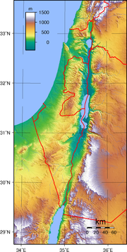
Physiographic regions
Israel is divided into four physiographic regions: the Mediterranean coastal plainIsraeli Coastal Plain
The Israeli coastal plain is the narrow coastal plain along Israel's Mediterranean Sea coast which houses 70% of the country's population. The plain extends north to south and is divided into a number of areas; the Plain of Zebulun , Hof HaCarmel , the Sharon plain , and the Plain of Judea The...
, the Central Hills, the Jordan Rift Valley
Jordan Rift Valley
The Jordan Rift Valley is an elongated depression located in modern-day Israel, Jordan and the Palestinian territories. This geographic region includes the Jordan River, Jordan Valley, Hula Valley, Lake Tiberias and the Dead Sea, the lowest land elevation on Earth...
and the Negev Desert
Negev
The Negev is a desert and semidesert region of southern Israel. The Arabs, including the native Bedouin population of the region, refer to the desert as al-Naqab. The origin of the word Neghebh is from the Hebrew root denoting 'dry'...
.
Coastal plain
The Israeli Coastal PlainIsraeli Coastal Plain
The Israeli coastal plain is the narrow coastal plain along Israel's Mediterranean Sea coast which houses 70% of the country's population. The plain extends north to south and is divided into a number of areas; the Plain of Zebulun , Hof HaCarmel , the Sharon plain , and the Plain of Judea The...
stretches from the Lebanese border in the north to Gaza
Gaza
Gaza , also referred to as Gaza City, is a Palestinian city in the Gaza Strip, with a population of about 450,000, making it the largest city in the Palestinian territories.Inhabited since at least the 15th century BC,...
in the south, interrupted only by Cape Carmel at Haifa Bay. It is about 40 kilometres (25 mi) wide at Gaza and narrows toward the north to about 5 kilometres (3.1 mi) at the Lebanese border. The region is fertile and humid
Humidity
Humidity is a term for the amount of water vapor in the air, and can refer to any one of several measurements of humidity. Formally, humid air is not "moist air" but a mixture of water vapor and other constituents of air, and humidity is defined in terms of the water content of this mixture,...
(historically malaria
Malaria
Malaria is a mosquito-borne infectious disease of humans and other animals caused by eukaryotic protists of the genus Plasmodium. The disease results from the multiplication of Plasmodium parasites within red blood cells, causing symptoms that typically include fever and headache, in severe cases...
l) and is known for its citrus
Citrus
Citrus is a common term and genus of flowering plants in the rue family, Rutaceae. Citrus is believed to have originated in the part of Southeast Asia bordered by Northeastern India, Myanmar and the Yunnan province of China...
orchard
Orchard
An orchard is an intentional planting of trees or shrubs that is maintained for food production. Orchards comprise fruit or nut-producing trees which are grown for commercial production. Orchards are also sometimes a feature of large gardens, where they serve an aesthetic as well as a productive...
s and viticulture
Wine
Wine is an alcoholic beverage, made of fermented fruit juice, usually from grapes. The natural chemical balance of grapes lets them ferment without the addition of sugars, acids, enzymes, or other nutrients. Grape wine is produced by fermenting crushed grapes using various types of yeast. Yeast...
. The plain is traversed by several short streams. From north to south these are: the Kishon, the Hadera, the Alexander, the Poleg, and the Yarkon. All of these streams were badly polluted, but in the last ten years much work is being done to clean them up. Today the Kishon, Alexander and Yarkon again flow year round, and also have parks along their banks.
The region is sub-divided into five sub-regions. The Western Galilee stretches from Rosh HaNikra
Rosh Hanikra (kibbutz)
Rosh HaNikra is a kibbutz in northern Israel. Located on the Mediterranean coast near the Rosh HaNikra grottoes and the border with Lebanon, it falls under the jurisdiction of Mateh Asher Regional Council...
in the far north, down to Israel's third-largest city, Haifa
Haifa
Haifa is the largest city in northern Israel, and the third-largest city in the country, with a population of over 268,000. Another 300,000 people live in towns directly adjacent to the city including the cities of the Krayot, as well as, Tirat Carmel, Daliyat al-Karmel and Nesher...
. It is a fertile region containing with a coastline with many small islands off of it. South of Haifa is the Hof HaCarmel region which runs to the town of Zikhron Ya'aqov
Zikhron Ya'aqov
Zikhron Ya'akov is a town in Israel, south of Haifa, and part of the Haifa District. It is located at the southern end of the Carmel mountain range overlooking the Mediterranean Sea, near the coastal highway...
. The Sharon plain is the next stage down the Coastal Plain, running from Zikhron Ya'aqov
Zikhron Ya'aqov
Zikhron Ya'akov is a town in Israel, south of Haifa, and part of the Haifa District. It is located at the southern end of the Carmel mountain range overlooking the Mediterranean Sea, near the coastal highway...
to Tel Aviv
Tel Aviv
Tel Aviv , officially Tel Aviv-Yafo , is the second most populous city in Israel, with a population of 404,400 on a land area of . The city is located on the Israeli Mediterranean coastline in west-central Israel. It is the largest and most populous city in the metropolitan area of Gush Dan, with...
's Yarkon River. This area is Israel's most densely populated. South of this, running to Nahal Shikma, is the Central Coastal Plain. The southern region of the Coastal Plain is the Southern Coastal Plain (also known as the Shephelah
Shephelah
The Shephelah is a designation usually applied to the region in south-central Israel of 10-15 km of low hills between the central Mount Hebron and the coastal plains of Philistia within the area of the Judea, at an altitude of 120-450 metres above sea level. The area is fertile, and a temperate...
, Plain of Judea
Judea
Judea or Judæa was the name of the mountainous southern part of the historic Land of Israel from the 8th century BCE to the 2nd century CE, when Roman Judea was renamed Syria Palaestina following the Jewish Bar Kokhba revolt.-Etymology:The...
, and Western Negev
Negev
The Negev is a desert and semidesert region of southern Israel. The Arabs, including the native Bedouin population of the region, refer to the desert as al-Naqab. The origin of the word Neghebh is from the Hebrew root denoting 'dry'...
) and extends south to the Gaza Strip
Gaza Strip
thumb|Gaza city skylineThe Gaza Strip lies on the Eastern coast of the Mediterranean Sea. The Strip borders Egypt on the southwest and Israel on the south, east and north. It is about long, and between 6 and 12 kilometres wide, with a total area of...
. It is divided into two. The Besor region, a savanna
Savanna
A savanna, or savannah, is a grassland ecosystem characterized by the trees being sufficiently small or widely spaced so that the canopy does not close. The open canopy allows sufficient light to reach the ground to support an unbroken herbaceous layer consisting primarily of C4 grasses.Some...
-type area with a relatively large number of communities, in the north, and the Agur-Halutsa region in the south which is very sparsely populated.
Central hills

Highland (geography)
The term highland or upland is used to denote any mountainous region or elevated mountainous plateau. Generally speaking, the term upland tends to be used for ranges of hills, typically up to 500-600m, and highland for ranges of low mountains.The Scottish Highlands refers to the mountainous...
region. In the north of this region lie the mountains and hills of Upper Galilee and Lower Galilee
Galilee
Galilee , is a large region in northern Israel which overlaps with much of the administrative North District of the country. Traditionally divided into Upper Galilee , Lower Galilee , and Western Galilee , extending from Dan to the north, at the base of Mount Hermon, along Mount Lebanon to the...
which are generally 500 metres (1,640 ft) to 700 metres (2,297 ft) in height although reach a maximum height of 1208 metres (3,963 ft) at Mount Meron. South of the Galilee, in the West Bank
West Bank
The West Bank ) of the Jordan River is the landlocked geographical eastern part of the Palestinian territories located in Western Asia. To the west, north, and south, the West Bank shares borders with the state of Israel. To the east, across the Jordan River, lies the Hashemite Kingdom of Jordan...
, are the Samaria
Samaria
Samaria, or the Shomron is a term used for a mountainous region roughly corresponding to the northern part of the West Bank.- Etymology :...
n Hills with numerous small, fertile valleys rarely reaching the height of 800 metres (2,625 ft). South of Jerusalem, also mainly within the West Bank, are the Judean Hills, including Mount Hebron
Mount Hebron
Mount Hebron is a geographic region and geologic formation in the southern West Bank, with its western foothills extending into Israel. The area was in biblical times a center of the Israelite and Hasmonean kingdoms. The region lends its name to the Mount Hebron Regional Council....
. The central highlands average 610 metres (2,001 ft) in height and reach their highest elevation at Har Meron
Har Meron
Mount Meron is a mountain in Israel above sea level. It is the highest mountain in Israel within the Green Line or the second highest point when including the Israeli-annexed part of the Golan Heights, which encompass the southern slopes of Mount Hermon...
, at 1208 metres (3,963 ft), in Galilee near Safed
Safed
Safed , is a city in the Northern District of Israel. Located at an elevation of , Safed is the highest city in the Galilee and of Israel. Due to its high elevation, Safed experiences warm summers and cold, often snowy, winters...
. Several valleys cut across the highlands roughly from east to west; the largest is the Jezreel Valley
Jezreel Valley
-Etymology:The Jezreel Valley takes its name from the ancient city of Jezreel which was located on a low hill overlooking the southern edge of the valley, though some scholars think that the name of the city originates from the name of the clan which founded it, and whose existence is mentioned in...
(also known as the Plain of Esdraelon), which stretches 48 kilometres (30 mi) from Haifa
Haifa
Haifa is the largest city in northern Israel, and the third-largest city in the country, with a population of over 268,000. Another 300,000 people live in towns directly adjacent to the city including the cities of the Krayot, as well as, Tirat Carmel, Daliyat al-Karmel and Nesher...
southeast to the valley of the Jordan River, and is 19 kilometres (12 mi) across at its widest point.
Jordan Rift Valley
Jordan Rift Valley
The Jordan Rift Valley is an elongated depression located in modern-day Israel, Jordan and the Palestinian territories. This geographic region includes the Jordan River, Jordan Valley, Hula Valley, Lake Tiberias and the Dead Sea, the lowest land elevation on Earth...
, which is a small part of the 6500 kilometres (4,039 mi)-long Syrian-East African Rift
Great Rift Valley
The Great Rift Valley is a name given in the late 19th century by British explorer John Walter Gregory to the continuous geographic trench, approximately in length, that runs from northern Syria in Southwest Asia to central Mozambique in South East Africa...
. In Israel the Rift Valley is dominated by the Jordan River, the Sea of Galilee
Sea of Galilee
The Sea of Galilee, also Kinneret, Lake of Gennesaret, or Lake Tiberias , is the largest freshwater lake in Israel, and it is approximately in circumference, about long, and wide. The lake has a total area of , and a maximum depth of approximately 43 m...
(an important freshwater source also known as Lake Tiberias and Lake Kinneret), and the Dead Sea
Dead Sea
The Dead Sea , also called the Salt Sea, is a salt lake bordering Jordan to the east and Israel and the West Bank to the west. Its surface and shores are below sea level, the lowest elevation on the Earth's surface. The Dead Sea is deep, the deepest hypersaline lake in the world...
. The Jordan, Israel's largest river (322 kilometres (200 mi)), originates in the Dan
Dan River (Israel)
The Dan River is the largest tributary of the Jordan river, whose source is located at the base of Mount Hermon. The river is so named after the Israelite city of Dan, which was captured by the Tribe of Dan during the Judges period. The tribe of Dan conquered the city, then named Laish and then...
, Baniyas
Baniyas
Baniyas is a city of northwestern Syria, located at the foot of the hill of Qalaat el-Marqab , 55 km to the south of Latakia and 35 km north of Tartous , and a Catholic titular see under the Latin name of Balanea, which is presently vacant.It is famous for its orchards...
, and Hasbani rivers near Mount Hermon in the Anti-Lebanon Mountains
Anti-Lebanon
The Anti-Lebanon mountains is the Western name for the Eastern Lebanon Mountain Range , which are a southwest-northeast-trending mountain range between Syria and Lebanon. Its Western name comes from the Greek word for ‘opposite’. The majority of the mountain range lies in Syria. The border between...
and flows south through the drained Hula Basin
Hulah Valley
The Hula Valley is an agricultural region in northern Israel with abundant fresh water. It is a major stopover for birds migrating along the Syrian-African Rift Valley between Africa, Europe, and Asia. The marshland around Lake Hula, a breeding grounds for malaria, was drained in the 1950s...
into the freshwater
Freshwater
Fresh water is naturally occurring water on the Earth's surface in ice sheets, ice caps, glaciers, bogs, ponds, lakes, rivers and streams, and underground as groundwater in aquifers and underground streams. Fresh water is generally characterized by having low concentrations of dissolved salts and...
Lake Tiberias. Lake Tiberias is 165 square kilometres (64 sq mi) in size and, depending on the season and rainfall, is at about 213 metres (699 ft) below sea level. With a water capacity estimated at 3 cubic kilometre (0.71973827581286 cu mi), it serves as the principal reservoir of the National Water Carrier (also known as the Kinneret-Negev Conduit). The Jordan River continues its course from the southern end of Lake Tiberias (forming the boundary between the West Bank
West Bank
The West Bank ) of the Jordan River is the landlocked geographical eastern part of the Palestinian territories located in Western Asia. To the west, north, and south, the West Bank shares borders with the state of Israel. To the east, across the Jordan River, lies the Hashemite Kingdom of Jordan...
and Jordan) to its terminus in the highly saline Dead Sea
Dead Sea
The Dead Sea , also called the Salt Sea, is a salt lake bordering Jordan to the east and Israel and the West Bank to the west. Its surface and shores are below sea level, the lowest elevation on the Earth's surface. The Dead Sea is deep, the deepest hypersaline lake in the world...
. The Dead Sea is 1020 square kilometres (394 sq mi) in size and, at 420 metres (1,378 ft) below sea level, is the lowest surface point on the earth. South of the Dead Sea, the Rift Valley continues in the Nahal HaArava
Arabah
The Arabah , also known as Aravah, is a section of the Great Rift Valley running in a north-south orientation between the southern end of the Sea of Galilee down to the Dead Sea and continuing further south where it ends at the Gulf of Aqaba. It includes most of the border between Israel to the...
(Wadi al Arabah), which has no permanent water flow, for 170 kilometres (106 mi) to the Gulf of Eilat.
Negev Desert
Negev
The Negev is a desert and semidesert region of southern Israel. The Arabs, including the native Bedouin population of the region, refer to the desert as al-Naqab. The origin of the word Neghebh is from the Hebrew root denoting 'dry'...
Desert comprises approximately 12000 square kilometres (4,633 sq mi), more than half of Israel's total land area. Geographically it is an extension of the Sinai Desert
Sinai Peninsula
The Sinai Peninsula or Sinai is a triangular peninsula in Egypt about in area. It is situated between the Mediterranean Sea to the north, and the Red Sea to the south, and is the only part of Egyptian territory located in Asia as opposed to Africa, effectively serving as a land bridge between two...
, forming a rough triangle with its base in the north near Beersheba
Beersheba
Beersheba is the largest city in the Negev desert of southern Israel. Often referred to as the "Capital of the Negev", it is the seventh-largest city in Israel with a population of 194,300....
, the Dead Sea, and the southern Judean Hills
Judean Mountains
The Judaean Mountains, ;, also Judaean Hills and Hebron Hills is a mountain range in Israel and the West Bank where Jerusalem and several other biblical cities are located. The mountains reach a height of 1,000 m.-Geography:...
, and it has its apex in the southern tip of the country at Eilat. Topographically, it parallels the other regions of the country, with lowlands in the west, hills in the central portion, and the Arabah valley as its eastern border.
Unique to the Negev region are the craterlike makhtesh
Makhtesh
A makhtesh is a geological landform considered unique to the Negev desert of Israel and the Sinai Peninsula. Although commonly known as "craters" , these formations are more accurately described as erosion cirques...
im cirques; Makhtesh Ramon
Makhtesh Ramon
Makhtesh Ramon is a geological feature of Israel's Negev desert. Located at the peak of Mount Negev, some 85 km south of the city of Beersheba, the landform is not actually an impact crater from a meteor, but rather is the world's largest makhtesh. The crater is 40 km long, 2-10 km wide and 500...
, Makhtesh Gadol
Makhtesh Gadol
HaMakhtesh HaGadol is a makhtesh, a geological erosional landform of Israel's Negev desert.A makhtesh has steep walls of resistant rock surrounding a deep closed valley. One of five makhteshim in Israel and seven in the world, HaMakhtesh HaGadol is the second largest, being exceptional in that it...
and Makhtesh Katan
Makhtesh Katan
HaMakhtesh HaKatan is a makhtesh, a geological erosional landform of Israel's Negev desert. One of five makhteshim in Israel, and seven in the world, it is the third largest in Israel at 5 km by 7 km. It was charted in 1942 by Jewish explorers....
. The Negev is also sub-divided into five different ecological regions: northern, western and central Negev, the high plateau and the Arabah Valley. The northern Negev receives 300 millimetres (11.8 in) of rain annually and has fairly fertile soils. The western Negev receives 250 millimetres (9.8 in) of rain per year, with light and partially sandy soils. The central Negev has an annual precipitation of 200 millimetres (7.9 in) and is characterized by impervious soil, allowing minimum penetration of water with greater soil erosion and water runoff. This can result in rare flash floods during heavy rains as water runs across the surface of the impervious desert soil. The high plateau area of Ramat HaNegev stands between 370 metres (1,214 ft) and 520 metres (1,706 ft) above sea level with extreme temperatures in summer and winter. The area gets 100 millimetres (3.9 in) of rain each year, with inferior and partially salty soils. The Arabah Valley along the Jordanian border stretches 180 kilometres (112 mi) from Eilat in the south to the tip of the Dead Sea in the north and is very arid with barely 50 millimetres (1.97 in) of rain annually.
Geology
Dead Sea
The Dead Sea , also called the Salt Sea, is a salt lake bordering Jordan to the east and Israel and the West Bank to the west. Its surface and shores are below sea level, the lowest elevation on the Earth's surface. The Dead Sea is deep, the deepest hypersaline lake in the world...
graben
Graben
In geology, a graben is a depressed block of land bordered by parallel faults. Graben is German for ditch. Graben is used for both the singular and plural....
which is a pull apart basin
Pull Apart Basin
250px|thumb|[[Cami Lake]] in [[Tierra del Fuego]] develops on a [[Patagonian Ice Sheet|glacially]] excavated pull apart basin along the [[Magallanes-Fagnano Fault]], hence its elongated form...
on the Dead Sea Transform
Dead Sea Transform
The Dead Sea Transform fault system, also sometimes referred to as the Dead Sea Rift, is a geologic fault which runs from the Maras Triple Junction to the northern end of the Red Sea Rift...
fault
Transform fault
A transform fault or transform boundary, also known as conservative plate boundary since these faults neither create nor destroy lithosphere, is a type of fault whose relative motion is predominantly horizontal in either sinistral or dextral direction. Furthermore, transform faults end abruptly...
.
The numerous limestone
Limestone
Limestone is a sedimentary rock composed largely of the minerals calcite and aragonite, which are different crystal forms of calcium carbonate . Many limestones are composed from skeletal fragments of marine organisms such as coral or foraminifera....
and sandstone
Sandstone
Sandstone is a sedimentary rock composed mainly of sand-sized minerals or rock grains.Most sandstone is composed of quartz and/or feldspar because these are the most common minerals in the Earth's crust. Like sand, sandstone may be any colour, but the most common colours are tan, brown, yellow,...
layers of the Israeli mountains serve as aquifer
Aquifer
An aquifer is a wet underground layer of water-bearing permeable rock or unconsolidated materials from which groundwater can be usefully extracted using a water well. The study of water flow in aquifers and the characterization of aquifers is called hydrogeology...
s through which water flows from the west flank to the east. Several springs have formed along the Dead Sea, each an oasis
Oasis
In geography, an oasis or cienega is an isolated area of vegetation in a desert, typically surrounding a spring or similar water source...
, most notably the oases at Ein Gedi
Ein Gedi
Ein Gedi is an oasis in Israel, located west of the Dead Sea, near Masada and the caves of Qumran.-Etymology:The name En-gedi is composed of two Hebrew words: ein means spring and gdi means goat-kid. En Gedi thus means "Kid spring."...
and Ein Bokek
Ein Bokek
Ein Bokek is a hotel and resort district on the Israeli shore of the Dead Sea, near Neve Zohar. It is under the jurisdiction of the Tamar Regional Council....
(Neve Zohar
Neve Zohar
Neve Zohar is a communal village in the South District of Israel, and the capital of the Tamar Regional Council. It is located on the junction of Highway 31 and Highway 90 , on the shores of the Dead Sea and 23 km from Arad by road...
) where settlements have developed. Israel also has a number of areas of karst topography
Karst topography
Karst topography is a geologic formation shaped by the dissolution of a layer or layers of soluble bedrock, usually carbonate rock such as limestone or dolomite, but has also been documented for weathering resistant rocks like quartzite given the right conditions.Due to subterranean drainage, there...
. Caves in the region have been used for thousands of years as shelter, storage rooms, barns and as places of public gatherings.
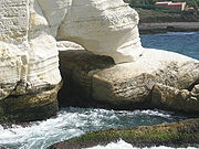
The far northern coastline of the country has some chalk
Chalk
Chalk is a soft, white, porous sedimentary rock, a form of limestone composed of the mineral calcite. Calcite is calcium carbonate or CaCO3. It forms under reasonably deep marine conditions from the gradual accumulation of minute calcite plates shed from micro-organisms called coccolithophores....
landscapes best seen at Rosh HaNikra
Rosh HaNikra grottoes
Rosh HaNikra is a geologic formation in Israel, located on the coast of the Mediterranean Sea, in the Western Galilee. It is a white chalk cliff face which opens up into spectacular grottos....
, a chalk cliff into which a series of grotto
Grotto
A grotto is any type of natural or artificial cave that is associated with modern, historic or prehistoric use by humans. When it is not an artificial garden feature, a grotto is often a small cave near water and often flooded or liable to flood at high tide...
es have been eroded.
Rivers and lakes
Israel's longest and most famous river is the 320 kilometres (199 mi) long River Jordan, which rises on the southern slopes of Mount Hermon in the Anti-Lebanon mountains. The river flows south through the freshwater Sea of GalileeSea of Galilee
The Sea of Galilee, also Kinneret, Lake of Gennesaret, or Lake Tiberias , is the largest freshwater lake in Israel, and it is approximately in circumference, about long, and wide. The lake has a total area of , and a maximum depth of approximately 43 m...
, and from there forms the boundary with the Kingdom of Jordan for much of its route, eventually emptying into the Dead Sea
Dead Sea
The Dead Sea , also called the Salt Sea, is a salt lake bordering Jordan to the east and Israel and the West Bank to the west. Its surface and shores are below sea level, the lowest elevation on the Earth's surface. The Dead Sea is deep, the deepest hypersaline lake in the world...
. The northern tributaries to the Jordan are the Dan
Dan River
The Dan River flows in the U.S. states of North Carolina and Virginia. It originates in Patrick County, Virginia, and crosses the state border into Stokes County, North Carolina. It then flows into Rockingham County. From there it goes back into Virginia. It reenters North Carolina near the...
, Banias, and Hasbani
Hasbani River
The Hasbani River , also known as Snir Stream within Israel, is a tributary of the Jordan river.The Hasbani River derives most of its discharge from two springs in Lebanon, the Wazzani and the Haqzbieh, the latter being a group of springs on the uppermost Hasbani...
. Only the Dan is within undisputed Israel; the Hasbani flows from Lebanon
Lebanon
Lebanon , officially the Republic of LebanonRepublic of Lebanon is the most common term used by Lebanese government agencies. The term Lebanese Republic, a literal translation of the official Arabic and French names that is not used in today's world. Arabic is the most common language spoken among...
and the Banias from territory which Israel captured from Syria in the Six-Day War
Six-Day War
The Six-Day War , also known as the June War, 1967 Arab-Israeli War, or Third Arab-Israeli War, was fought between June 5 and 10, 1967, by Israel and the neighboring states of Egypt , Jordan, and Syria...
in 1967.
Israel's largest and most notable freshwater
Freshwater
Fresh water is naturally occurring water on the Earth's surface in ice sheets, ice caps, glaciers, bogs, ponds, lakes, rivers and streams, and underground as groundwater in aquifers and underground streams. Fresh water is generally characterized by having low concentrations of dissolved salts and...
lake is the Sea of Galilee
Sea of Galilee
The Sea of Galilee, also Kinneret, Lake of Gennesaret, or Lake Tiberias , is the largest freshwater lake in Israel, and it is approximately in circumference, about long, and wide. The lake has a total area of , and a maximum depth of approximately 43 m...
(also known as the Kinneret and Lake Tiberias), a pear-shaped lake located in the north-east of the country. The lake is 23 kilometres (14 mi) from north to south, with a maximum width of 13 kilometres (8 mi) in the north. The lake reaches depths of 46 metres (151 ft) and covers 166 square kilometres (64 sq mi). The Sea of Galilee lies 207 metres (679 ft) below sea level. In a previous geological epoch
Series (stratigraphy)
Series are subdivisions of rock layers made based on the age of the rock and corresponding to the dating system unit called an epoch, both being formally defined international conventions of the geological timescale. A series is therefore a sequence of rock depositions defining a...
the lake was part of a large inland sea which extended from the Hula
Hula
Hula is a dance form accompanied by chant or song . It was developed in the Hawaiian Islands by the Polynesians who originally settled there. The hula dramatizes or portrays the words of the oli or mele in a visual dance form....
marshes in northern Israel to 64 kilometres (40 mi) south of the Dead Sea. The bed of the lake forms part of the Great Rift Valley
Great Rift Valley
The Great Rift Valley is a name given in the late 19th century by British explorer John Walter Gregory to the continuous geographic trench, approximately in length, that runs from northern Syria in Southwest Asia to central Mozambique in South East Africa...
.
South of the Sea of Galilee lies the saltwater
Seawater
Seawater is water from a sea or ocean. On average, seawater in the world's oceans has a salinity of about 3.5% . This means that every kilogram of seawater has approximately of dissolved salts . The average density of seawater at the ocean surface is 1.025 g/ml...
Dead Sea
Dead Sea
The Dead Sea , also called the Salt Sea, is a salt lake bordering Jordan to the east and Israel and the West Bank to the west. Its surface and shores are below sea level, the lowest elevation on the Earth's surface. The Dead Sea is deep, the deepest hypersaline lake in the world...
which forms the border between Israel and Jordan and is 418 metres (1,371 ft) below sea level, making it the lowest water surface on Earth. The Dead Sea is 67 kilometres (42 mi) long with a maximum width of 16 kilometres (10 mi) and also makes up part of the Rift Valley. A peninsula juts out into the lake from the eastern shore, south of which the lake is shallow, less than 6 metres (19.7 ft) deep. To the north is the lake's greatest depth.
There are no navigable, artificial waterways in Israel, although the National Water Carrier, a conduit for drinking water, may be considered to be an artificial waterway. The idea of a channel
Dead Sea canal
The Mediterranean-Dead Sea canal is a proposed project to dig a canal from the Mediterranean Sea to the Dead Sea, taking advantage of the 400-metre difference in water level between the seas. It is not to be confused with the Red Sea-Dead Sea Canal . The project could correct the drop in the level...
connecting the Mediterranean and Dead Seas or the Red and Dead Seas has been discussed.
Selected elevations
The following are selected elevations of notable locations, from highest to lowest:| Location | Region | Elevation (feet) | Elevation (meters) |
|---|---|---|---|
| Mount Hermon Mount Hermon Mount Hermon is a mountain cluster in the Anti-Lebanon mountain range. Its summit straddles the border between Syria and Lebanon and, at 2,814 m above sea level, is the highest point in Syria. On the top there is “Hermon Hotel”, in the buffer zone between Syria and Israeli-occupied... |
Israeli occupied Golan Heights | 7,336 ft. | 2,236 m. |
| Mount Meron | Upper Galilee | 3,964 ft. | 1,208 m. |
| Mount Ramon Mount Ramon Mount Ramon is a mountain in the Negev desert in Israel, near the Egyptian border and west of the well-known Ramon Crater. Its elevation is above sea level and it is the summit of the Negev Mountains.It is the highest mountain in southern Israel.... |
Negev | 3,396 ft. | 1,035 m. |
| Mount of Olives Mount of Olives The Mount of Olives is a mountain ridge in East Jerusalem with three peaks running from north to south. The highest, at-Tur, rises to 818 meters . It is named for the olive groves that once covered its slopes... |
Israeli occupied East Jerusalem | 2,739 ft. | 835 m. |
| Mount Tabor Mount Tabor -Places:*Mount Tabor, a hill in Israel near Nazareth believed by many to be the site of the Transfiguration of ChristIn the United States:*Mount Tabor, Indiana, an unincorporated community... |
Lower Galilee | 1,930 ft. | 588 m. |
| Mount Carmel Mount Carmel Mount Carmel ; , Kármēlos; , Kurmul or جبل مار إلياس Jabal Mar Elyas 'Mount Saint Elias') is a coastal mountain range in northern Israel stretching from the Mediterranean Sea towards the southeast. Archaeologists have discovered ancient wine and oil presses at various locations on Mt. Carmel... |
Haifa | 1,792 ft. | 546 m. |
| Dead Sea Dead Sea The Dead Sea , also called the Salt Sea, is a salt lake bordering Jordan to the east and Israel and the West Bank to the west. Its surface and shores are below sea level, the lowest elevation on the Earth's surface. The Dead Sea is deep, the deepest hypersaline lake in the world... |
Judean Desert | – 1,368 ft. | – 417 m. |
Climate

Mediterranean climate
A Mediterranean climate is the climate typical of most of the lands in the Mediterranean Basin, and is a particular variety of subtropical climate...
with long, hot, rainless summers and relatively short, cool, rainy winters (Köppen climate classification
Köppen climate classification
The Köppen climate classification is one of the most widely used climate classification systems. It was first published by Crimea German climatologist Wladimir Köppen in 1884, with several later modifications by Köppen himself, notably in 1918 and 1936...
Csa). The climate is as such due to Israel's location between the subtropical
Subtropics
The subtropics are the geographical and climatical zone of the Earth immediately north and south of the tropical zone, which is bounded by the Tropic of Cancer and the Tropic of Capricorn, at latitudes 23.5°N and 23.5°S...
aridity of the Sahara
Sahara
The Sahara is the world's second largest desert, after Antarctica. At over , it covers most of Northern Africa, making it almost as large as Europe or the United States. The Sahara stretches from the Red Sea, including parts of the Mediterranean coasts, to the outskirts of the Atlantic Ocean...
and the Arabian deserts, and the subtropical humidity of the Levant
Levant
The Levant or ) is the geographic region and culture zone of the "eastern Mediterranean littoral between Anatolia and Egypt" . The Levant includes most of modern Lebanon, Syria, Jordan, Israel, the Palestinian territories, and sometimes parts of Turkey and Iraq, and corresponds roughly to the...
and Eastern Mediterranean. The climate conditions are highly variable within the state and modified locally by altitude, latitude, and the proximity to the Mediterranean.
On average, January is the coldest month with average temperatures ranging from 6 to 15 °C (42.8 to 59 F), and July and August are the hottest months at 22 to 33 °C (71.6 to 91.4 F), on average across the country. Summers are very humid along the Mediterranean coast but dry in the central highlands, the Rift Valley, and the Negev
Negev
The Negev is a desert and semidesert region of southern Israel. The Arabs, including the native Bedouin population of the region, refer to the desert as al-Naqab. The origin of the word Neghebh is from the Hebrew root denoting 'dry'...
Desert. In Eilat, a desert city, summer daytime-temperatures are often the highest in the state, at times reaching 44 to 46 °C (111.2 to 114.8 F). More than 70% of the average rainfall in Israel falls between November and March; June through September are usually rainless. Rainfall is unevenly distributed, significantly lower in the south of the country. In the extreme south, rainfall averages near 30 millimetres (1.18 in) annually; in the north, average annual rainfall exceeds 900 millimetres (35.4 in). Rainfall varies from season to season and from year to year, particularly in the Negev Desert. Precipitation is often concentrated in violent storms, causing erosion
Erosion
Erosion is when materials are removed from the surface and changed into something else. It only works by hydraulic actions and transport of solids in the natural environment, and leads to the deposition of these materials elsewhere...
and flash floods. In winter, precipitation often takes the form of snow at the higher elevations of the central highlands, including Jerusalem. Mount Hermon has seasonal snow which covers all three of its peaks for most of the year in winter and spring. In rare occasions, snow gets to the northern mountain peaks and only in extremely rare occasions even to the coast. The areas of the country most cultivated are those receiving more than 300 millimetres (11.8 in) of rainfall annually, making approximately one-third of the country cultivable.
Thunderstorms and hail are common throughout the rainy season and waterspouts occasionally hit the Mediterranean coast, capable of causing only minor damage. However, supercell thunderstorms and a true F2 tornado
Tornado
A tornado is a violent, dangerous, rotating column of air that is in contact with both the surface of the earth and a cumulonimbus cloud or, in rare cases, the base of a cumulus cloud. They are often referred to as a twister or a cyclone, although the word cyclone is used in meteorology in a wider...
hit the Western Galilee in April 2006, causing significant damage and 75 injuries.
Recently, Israel sees heat waves frequently. 2010 was the hottest year in the history of Israel with absolute record high in several places in August. The heat became stronger from August when temperatures were considerably above the average. October and November were also dry, and November was almost rainless when it was supposed to be rainy.
Climate charts of different locations in Israel
Natural resources
Unlike much of the Middle East which is rich in the lucrative natural resource of oil, Israel has limited natural resources. These include copper, phosphates, bromideBromide
A bromide is a chemical compound containing bromide ion, that is bromine atom with effective charge of −1. The class name can include ionic compounds such as caesium bromide or covalent compounds such as sulfur dibromide.-Natural occurrence:...
, potash
Potash
Potash is the common name for various mined and manufactured salts that contain potassium in water-soluble form. In some rare cases, potash can be formed with traces of organic materials such as plant remains, and this was the major historical source for it before the industrial era...
, clay
Clay
Clay is a general term including many combinations of one or more clay minerals with traces of metal oxides and organic matter. Geologic clay deposits are mostly composed of phyllosilicate minerals containing variable amounts of water trapped in the mineral structure.- Formation :Clay minerals...
, sand
Sand
Sand is a naturally occurring granular material composed of finely divided rock and mineral particles.The composition of sand is highly variable, depending on the local rock sources and conditions, but the most common constituent of sand in inland continental settings and non-tropical coastal...
, sulfur
Sulfur
Sulfur or sulphur is the chemical element with atomic number 16. In the periodic table it is represented by the symbol S. It is an abundant, multivalent non-metal. Under normal conditions, sulfur atoms form cyclic octatomic molecules with chemical formula S8. Elemental sulfur is a bright yellow...
, asphalt
Asphalt
Asphalt or , also known as bitumen, is a sticky, black and highly viscous liquid or semi-solid that is present in most crude petroleums and in some natural deposits, it is a substance classed as a pitch...
, and manganese
Manganese
Manganese is a chemical element, designated by the symbol Mn. It has the atomic number 25. It is found as a free element in nature , and in many minerals...
. Small amounts of natural gas and crude oil are present, often too little to merit commercial extraction. In 2009, significant reserves of natural gas were discovered at the Tamar 1 offshore drilling
Tamar gas field
The Tamar gas field is a natural gas field in the Mediterranean Sea off the coast of Israel, discovered in 2009. The gas field is located roughly west of Haifa in waters deep.-History:...
site, 90 kilometers west of Haifa. It is the largest natural gas reserve ever discovered in Israel.
Environmental concerns
Israel has a large number of environmental concerns ranging from natural hazards to man-made issues both resulting from ancient times to modern development. Natural hazards facing the country include sandstormsDust storm
A dust / sand storm is a meteorological phenomenon common in arid and semi-arid regions. Dust storms arise when a gust front or other strong wind blows loose sand and dirt from a dry surface. Particles are transported by saltation and suspension, causing soil to move from one place and deposition...
which sometimes occur during spring in the desert south, droughts which are usually concentrated in summer months, flash flood
Flash flood
A flash flood is a rapid flooding of geomorphic low-lying areas—washes, rivers, dry lakes and basins. It may be caused by heavy rain associated with a storm, hurricane, or tropical storm or meltwater from ice or snow flowing over ice sheets or snowfields...
s which create great danger in the deserts due to their lack of notice, and regular earthquakes, most of which are small, although there is a constant risk due to Israel's location along the Jordan Rift Valley
Jordan Rift Valley
The Jordan Rift Valley is an elongated depression located in modern-day Israel, Jordan and the Palestinian territories. This geographic region includes the Jordan River, Jordan Valley, Hula Valley, Lake Tiberias and the Dead Sea, the lowest land elevation on Earth...
. Current environmental concerns include the lack of arable land
Arable land
In geography and agriculture, arable land is land that can be used for growing crops. It includes all land under temporary crops , temporary meadows for mowing or pasture, land under market and kitchen gardens and land temporarily fallow...
and natural fresh water resources. Whilst measures have been taken to irrigate and grow in the desert, the amount of water needed here poses issues. Desertification
Desertification
Desertification is the degradation of land in drylands. Caused by a variety of factors, such as climate change and human activities, desertification is one of the most significant global environmental problems.-Definitions:...
is also a risk possible on the desert fringe, whilst air pollution from industrial and vehicle emissions and groundwater pollution
Water pollution
Water pollution is the contamination of water bodies . Water pollution occurs when pollutants are discharged directly or indirectly into water bodies without adequate treatment to remove harmful compounds....
from industrial and domestic waste are also issues facing the country. Furthermore, the effects of the use of chemical fertilizers, and pesticide
Pesticide
Pesticides are substances or mixture of substances intended for preventing, destroying, repelling or mitigating any pest.A pesticide may be a chemical unicycle, biological agent , antimicrobial, disinfectant or device used against any pest...
s are issues facing the country.
Israel has signed many international environmental agreements and is party to:
- Convention on Biological DiversityConvention on Biological DiversityThe Convention on Biological Diversity , known informally as the Biodiversity Convention, is an international legally binding treaty...
- UNFCCC – Climate Change
- United Nations Convention to Combat DesertificationUnited Nations Convention to Combat DesertificationThe United Nations Convention to Combat Desertification in Those Countries Experiencing Serious Drought and/or Desertification, Particularly in Africa is a Convention to combat desertification and mitigate the effects of drought through national action programs that incorporate long-term strategies...
- Convention on the International Trade in Endangered Species of Wild Flora and FaunaConvention on the International Trade in Endangered Species of Wild Flora and FaunaCITES is a multilateral treaty, drafted as a result of a resolution adopted in 1963 at a meeting of members of the International Union for Conservation of Nature...
- Hazardous Wastes
- Nuclear Test Ban
- Montreal ProtocolMontreal ProtocolThe Montreal Protocol on Substances That Deplete the Ozone Layer is an international treaty designed to protect the ozone layer by phasing out the production of numerous substances believed to be responsible for ozone depletion...
– Ozone Layer Protection - MARPOL 73/78MARPOL 73/78Marpol 73/78 is the International Convention for the Prevention of Pollution From Ships, 1973 as modified by the Protocol of 1978....
– Ship Pollution - Convention on Wetlands of International Importance Especially As Waterfowl Habitat
Furthermore, the country has signed, but not ratified:
- Kyoto ProtocolKyoto ProtocolThe Kyoto Protocol is a protocol to the United Nations Framework Convention on Climate Change , aimed at fighting global warming...
- Marine Life Conservation
Rural settlements
Israel's rural space includes several unique kinds of settlements, notably the moshavMoshav
Moshav is a type of Israeli town or settlement, in particular a type of cooperative agricultural community of individual farms pioneered by the Labour Zionists during the second aliyah...
and the kibbutz
Kibbutz
A kibbutz is a collective community in Israel that was traditionally based on agriculture. Today, farming has been partly supplanted by other economic branches, including industrial plants and high-tech enterprises. Kibbutzim began as utopian communities, a combination of socialism and Zionism...
. Originally these were collective and cooperative settlements respectively. Over time, the degree of cooperation in these settlements has decreased and in several of them the cooperative structure has been dismantled altogether. All rural settlements and many small towns (some of which are dubbed "rurban settlements") are incorporated in regional councils. Land use in Israel is 17% arable land, 4% permanent crops, and 79% other uses. As of 2003 1940 square kilometres (749 sq mi) were irrigated.
There are 242 Israeli settlements and civilian land use sites in the West Bank
West Bank
The West Bank ) of the Jordan River is the landlocked geographical eastern part of the Palestinian territories located in Western Asia. To the west, north, and south, the West Bank shares borders with the state of Israel. To the east, across the Jordan River, lies the Hashemite Kingdom of Jordan...
, 42 in the Golan Heights, and 29 in East Jerusalem.
Human geography
In 2009, the population of Israel was 7.5 million people, 5.7 million of them Jewish.For statistical purposes, the country has three metropolises; Gush Dan
Gush Dan
The Tel Aviv Metropolitan Area , or Gush Dan , is a metropolitan area including areas from both the Tel Aviv and the Central Districts of Israel. The area is closely linked to the city of Tel Aviv through social, economic, and cultural ties. It is located along the Israeli Mediterranean coastline...
-Tel Aviv (population 3,150,000), Haifa
Haifa
Haifa is the largest city in northern Israel, and the third-largest city in the country, with a population of over 268,000. Another 300,000 people live in towns directly adjacent to the city including the cities of the Krayot, as well as, Tirat Carmel, Daliyat al-Karmel and Nesher...
(population 996,000), and Beersheba
Beersheba
Beersheba is the largest city in the Negev desert of southern Israel. Often referred to as the "Capital of the Negev", it is the seventh-largest city in Israel with a population of 194,300....
(population 531,600). Some argue that Jerusalem, Israel's largest city with a population of 763,600, and Nazareth
Nazareth
Nazareth is the largest city in the North District of Israel. Known as "the Arab capital of Israel," the population is made up predominantly of Palestinian Arab citizens of Israel...
, should also be classified as metropolitan areas. In total, Israel has 74 cities
City council (Israel)
A City council is the official designation of a city within Israel's system of local government.City council status may be granted by the Interior Minister to a municipality, usually a local council, whose population surpasses 20,000 and whose character is urban, defined as having areas zoned for...
, 14 of which have populations of over 100,000. Other forms of local government in Israel
Local government in Israel
The local governments of Israel , are the set of bodies charged with providing services such as urban planning, zoning, and the provision of drinking water and emergency services, as well as education and culture, as per guidelines of the Interior Ministry for communities of all sizes in the country...
are local councils
Local council (Israel)
Local councils are one of the three types of local government found in Israel, with the other two being cities and regional councils. As of 2003, there were 144 local councils in Israel, these being settlements which pass a minimum threshold enough to justify their operations as independent...
of which there are 144 governing small municipalities generally over 2,000 in population, and regional councils
Regional council (Israel)
Regional councils are one of the three types of local government entities found in Israel, with the other two being cities and local councils. As of 2003, there were 53 regional councils in Israel, usually responsible for governing a number of settlements spread across rural areas...
of which there are 53, governing a group of small communities over a relatively large geographical area.
Israel's population is diverse demographically; 76% Jewish, 20% Arab, and 4% unaffiliated. In terms of religion, 76% are Jewish, 16% Muslim, 2% Christian, 2% Druze
Druze
The Druze are an esoteric, monotheistic religious community, found primarily in Syria, Lebanon, Israel, and Jordan, which emerged during the 11th century from Ismailism. The Druze have an eclectic set of beliefs that incorporate several elements from Abrahamic religions, Gnosticism, Neoplatonism...
, and 4% are unclassified by choice. 8% of Israeli Jews are haredi; 9% are "religious", 12% "religious-traditionalists", 27% are "non-religious traditionalists", and 43% are "secular". Other small, but notable groups in Israel, include Circassians of whom there are approximately 3,000 living mostly in two northern villages, 2,500 Lebanese
Lebanese people
The Lebanese people are a nation and ethnic group of Levantine people originating in what is today the country of Lebanon, including those who had inhabited Mount Lebanon prior to the creation of the modern Lebanese state....
, and 5,000 Armenians
Armenians
Armenian people or Armenians are a nation and ethnic group native to the Armenian Highland.The largest concentration is in Armenia having a nearly-homogeneous population with 97.9% or 3,145,354 being ethnic Armenian....
predominantly in Jerusalem.
Political geography

Israel is divided into six main administrative districts which are further divided into fifteen sub-districts. Each sub-district is further divided into natural regions, of which there are 50. The districts from north to south, and their sub-districts are:
| Number | District | Main City | Provinces | Number of Residents |
|---|---|---|---|---|
| 1 | Jerusalem Jerusalem District The Jerusalem District is one of six administrative districts of Israel. The district capital is Jerusalem. The Jerusalem District has a land area of 652 km². The population of 910,300 is 67.8% Jewish and 30.6% Arab... |
Jerusalem | Jerusalem | 910,300 |
| 2 | North | Nazareth Illit Nazareth Illit Nazareth Illit is a city in the North District of Israel. At the end of 2007 it had a population of 40,800.Nazareth Illit was founded in the 1950s. Foundations were laid in 1954 and first residents moved in two years later... |
Kinneret Sea of Galilee The Sea of Galilee, also Kinneret, Lake of Gennesaret, or Lake Tiberias , is the largest freshwater lake in Israel, and it is approximately in circumference, about long, and wide. The lake has a total area of , and a maximum depth of approximately 43 m... , Safed Safed Safed , is a city in the Northern District of Israel. Located at an elevation of , Safed is the highest city in the Galilee and of Israel. Due to its high elevation, Safed experiences warm summers and cold, often snowy, winters... , Acre, Jezreel Valley Jezreel Valley -Etymology:The Jezreel Valley takes its name from the ancient city of Jezreel which was located on a low hill overlooking the southern edge of the valley, though some scholars think that the name of the city originates from the name of the clan which founded it, and whose existence is mentioned in... , Golan Heights |
1,242,100 |
| 3 | Haifa Haifa District Haifa District is an administrative district surrounding the city of Haifa, Israel. The district is one of six administrative districts of Israel, and its capital is Haifa... |
Haifa Haifa Haifa is the largest city in northern Israel, and the third-largest city in the country, with a population of over 268,000. Another 300,000 people live in towns directly adjacent to the city including the cities of the Krayot, as well as, Tirat Carmel, Daliyat al-Karmel and Nesher... |
Haifa Haifa Haifa is the largest city in northern Israel, and the third-largest city in the country, with a population of over 268,000. Another 300,000 people live in towns directly adjacent to the city including the cities of the Krayot, as well as, Tirat Carmel, Daliyat al-Karmel and Nesher... , Hadera Hadera Hadera is a city located in the Haifa District of Israel approximately from the major cities of Tel Aviv and Haifa. The city is located along of the Israeli Mediterranean Coastal Plain... |
880,000 |
| 4 | Center | Ramla Ramla Ramla , is a city in central Israel. The city is predominantly Jewish with a significant Arab minority. Ramla was founded circa 705–715 AD by the Umayyad Caliph Suleiman ibn Abed al-Malik after the Arab conquest of the region... |
Ramla Ramla Ramla , is a city in central Israel. The city is predominantly Jewish with a significant Arab minority. Ramla was founded circa 705–715 AD by the Umayyad Caliph Suleiman ibn Abed al-Malik after the Arab conquest of the region... , Sharon Sharon Sharon can be a female name which can be spelled with one "r" or two . It also refers to several places in the world.It derives from a Israelite place name meaning "forest" in Hebrew, referring to a fertile plain near the coast of Israel. This gives its name to a type of flowering shrub, the rose... (Netanya Netanya Netanya is a city in the Northern Centre District of Israel, and is the capital of the surrounding Sharon plain. It is located north of Tel Aviv, and south of Haifa between the 'Poleg' stream and Wingate Institute in the south and the 'Avichail' stream in the north.Its of beaches have made the... ), Petah Tikva Petah Tikva Petah Tikva known as Em HaMoshavot , is a city in the Center District of Israel, east of Tel Aviv.According to the Central Bureau of Statistics, at the end of 2009, the city's population stood at 209,600. The population density is approximately... , Rehovot Rehovot Rehovot is a city in the Center District of Israel, about south of Tel Aviv. According to the Israel Central Bureau of Statistics , at the end of 2009 the city had a total population of 112,700. Rehovot's official website estimates the population at 114,000.Rehovot was built on the site of Doron,... |
1,770,200 |
| 5 | Tel Aviv Tel Aviv District The Tel Aviv District is the smallest and most densely populated of six administrative districts of Israel with a population of 1.2 million residents... |
Tel Aviv Tel Aviv Tel Aviv , officially Tel Aviv-Yafo , is the second most populous city in Israel, with a population of 404,400 on a land area of . The city is located on the Israeli Mediterranean coastline in west-central Israel. It is the largest and most populous city in the metropolitan area of Gush Dan, with... |
Tel Aviv Tel Aviv Tel Aviv , officially Tel Aviv-Yafo , is the second most populous city in Israel, with a population of 404,400 on a land area of . The city is located on the Israeli Mediterranean coastline in west-central Israel. It is the largest and most populous city in the metropolitan area of Gush Dan, with... |
1,227,000 |
| 6 | South South District (Israel) The Southern District is one of Israel's six administrative districts, and is the largest in terms of land area as well as the most sparsely populated. It covers most of the Negev desert, as well as the Arabah valley. The population of the Southern District is 1,002,400. It is 86% Jewish and 14%... |
Beersheba Beersheba Beersheba is the largest city in the Negev desert of southern Israel. Often referred to as the "Capital of the Negev", it is the seventh-largest city in Israel with a population of 194,300.... |
Ashkelon Ashkelon Ashkelon is a coastal city in the South District of Israel on the Mediterranean coast, south of Tel Aviv, and north of the border with the Gaza Strip. The ancient seaport of Ashkelon dates back to the Neolithic Age... , Beersheba Beersheba Beersheba is the largest city in the Negev desert of southern Israel. Often referred to as the "Capital of the Negev", it is the seventh-largest city in Israel with a population of 194,300.... |
1,053,600 |
| 7 | Judea and Samaria | Modi'in Illit Modi'in Illit Modi'in Illit is a Haredi Israeli settlement and a city in the West Bank, situated midway between Jerusalem and Tel Aviv. Modi'in Illit was granted city status by the Israeli government in 2008. It is located six kilometres northeast of Modi'in-Maccabim-Re'ut and is often referred to as Kiryat... (Largest city) |
--- | 290,400 |
The Golan sub-district, which contains four natural regions, is included in this amount, although it is not regarded by the UN or the vast majority of its membership as Israeli territory. Most of the West Bank
West Bank
The West Bank ) of the Jordan River is the landlocked geographical eastern part of the Palestinian territories located in Western Asia. To the west, north, and south, the West Bank shares borders with the state of Israel. To the east, across the Jordan River, lies the Hashemite Kingdom of Jordan...
, known in Israel as the Judea and Samaria
Judea and Samaria
Judea and Samaria Area is the official Israeli term roughly corresponding to the territory usually known outside Israel as the West Bank and to the Israeli settlements there that are not governed as part of Jerusalem.-Terminology:...
area, is not included, since Israel has not fully applied its jurisdiction there. However, part of the West Bank, including East Jerusalem
East Jerusalem
East Jerusalem or Eastern Jerusalem refer to the parts of Jerusalem captured and annexed by Jordan in the 1948 Arab-Israeli War and then captured and annexed by Israel in the 1967 Six-Day War...
is governed as part of Jerusalem District though this step has also been condemned by the UN.