

Gush Dan
Encyclopedia
The Tel Aviv Metropolitan Area , or Gush Dan , is a metropolitan area
including areas from both the Tel Aviv
and the Central
Districts of Israel
. The area is closely linked to the city of Tel Aviv through social, economic, and cultural ties. It is located along the Israeli Mediterranean coastline
. The Tel Aviv metropolitan area is the largest metropolitan area in Israel and consists an estimated population of 3,206,400 residents, 95% of whom (3,000,000) are Israeli Jews. It houses about 42% of Israel's population.
Over 300,000
Over 200,000
Over 100,000
Over 50,000
Over 10,000
Hod HaSharon
,
Modi'in Illit
,
Rosh HaAyin
,
Ramat HaSharon
,
Ness Ziona
,
El'ad
,
Yavne
,
Kiryat Ono,
Yehud-Monosson
,
Tira
,
Giv'at Shmuel
,
Kafr Qasim
,
Qalansawe
,
Be'er Ya'akov,
Even Yehuda,
Gan Yavne
,
Ganei Tikva
,
Gedera
,
Giv'at Shmuel
,
Jaljulia
,
Kfar Yona,
Kiryat Ekron
,
Kokhav Ya'ir
,
Mazkeret Batya
,
Shoham
,
Tel Mond
,
Tzoran-Kadima
divides the Tel Aviv metropolitan area into four:
Notes
in the ancient Kingdom of Israel
. According to the biblical narrative, the tribe had originally tried to settle in the central coastal area of Canaan
, but due to enmity with the Philistines who had already settled there, were only able to camp in the hill country overlooking the Sorek Valley. The camp location became known as Mahaneh Dan ("Camps of Dan"). The region they attempted to settle included the area as far north as Joppa
and as far south as Shephelah
in the area of Timnah. As a result of the pressure from the Philistines, the tribe abandoned hopes of settling near the central coast, instead migrating to the north of the country. After conquering Laish, the tribe refounded it as their capital and renamed it Dan. In remembrance of the original territory assignments, this coastal region is referred to as Gush Dan.
The modern city of Tel Aviv
was founded in 1909 as a suburb of the Arab coastal city of Jaffa
. The city grew rapidly in the ensuing decades thanks to European immigration, with the population reaching 150,000 in 1934, and 230,000 14 years later when Israel gained its independence. Before the establishment of the state, other towns in the Gush Dan were founded as well, such as Petah Tikva
in 1878, Rishon LeZion in 1882, Ness Ziona
in 1883, Rehovot
in 1890, and the majority of other Gush Dan cities were established before 1948.
In 1947, the Jewish population of the Gush Dan was nearly 400,000, comprising the majority of the Jewish population of Mandate Palestine. As such almost all of it was included in the Jewish state proposed by the 1947 United Nations Partition Plan for Palestine. After the 1948 Arab–Israeli War the Arab population of the region, which had been nearly 150,000 before the war, was reduced to around 10,000. They were quickly replaced by a larger number of Jews fleeing from postwar Europe and persecution in Arab countries. However, at this time many new immigrants did not come to Tel Aviv. In the 1950s towns were built on the edges of the Gush Dan, including Ashdod, Rosh HaAyin
and Yavne
. The nation's sole port at the time was located in the northern city of Haifa and its evolving metropolitan area making that city at least as important as Tel Aviv. At the same time the new government was trying to disperse the nation's population to the periphery, discouraging settlement in the already populated Gush Dan. The slowed the growth of the Gush Dan, but the area still more than doubled in population within 20 years of the establishment of the state. The opening of the Port of Ashdod in the southern Gush Dan also increased the area's importance, with Haifa's importance diminishing, and Tel Aviv's increasing due to its proximity to the Port of Ashdod. Tel Aviv itself witnessed population decreases in the 1970s, and 80s with outer regions of the Gush Dan with lower costs of living absorbing many people who left Tel Aviv. Only in the 1990s with the immigration of 1 million Russians, 40,000 Ethiopian Jews, and many others to Israel, as well as a boom in the religious population, did Tel Aviv begin to grow again. The demand for housing increased dramatically, with new cities such as Modiin, El'ad
being built, and cities like Ashdod more than doubling in population )from 83,000 in 1990, to 175,000 in 2000. In the 2000s the area continued to grow, attracting many immigrants from the Haifa metropolitan area
. In 2010 the Gush Dan is home to 3,200,000 people and is the commercial, economical, cultural, and industrial center of Israel
. Despite attempts by the Israeli government to encourage migration to the Galilee
and the Negev
, the Gush Dan retains its position as the heart of the State of Israel.
 Universities
Colleges
 Tel Aviv
Giv'atayim
Herzliya
Ramat Gan
Ramat HaSharon
Holon
Or Yehuda
Rishon LeZion
Netanya
Yehud
Bat Yam
Petah Tikva
Rehovot
Ra'anana
Kfar Sava
Ramla
Lod
 The Dan Bus Company
is primarily focused on serving the Gush Dan, although it is being replaced by the Kavim
company in many of the Gush Dan's cities. Much of Israel's national highway network
feeds into the area, such as Highway 1
, Highway 2
, Highway 4
, and Highway 5
. Gush Dan is also served by the local Ayalon Highway
. Israel Railways
, the state owned, national rail network provider, also feeds most traffic into or within the Gush Dan region. The Tel Aviv Light Rail, currently under construction, will also be a major feature in the regions future transport, as will thehigh speed service to Jerusalem. Two airports are located in the Gush Dan; Sde Dov Airport
located in Tel Aviv which sees an average of 700,000 passenger movements a year, is located north of the Yarkon River hosts flights to Rosh Pina, and Haifa
in the north as well as to Ein Yahav
, Ovda International Airport
, and Eilat in the south as well as to nearby Cyprus
, Rhodes
in Greece
, and Aqaba
in Jordan
. Meanwhile Ben Gurion International Airport
in Lod
which is Israel
's largest airport handles over 12 million passengers a year and offers flights to destinations in Europe
, Africa
, Asia
, and The Americas
.
Metropolitan area
The term metropolitan area refers to a region consisting of a densely populated urban core and its less-populated surrounding territories, sharing industry, infrastructure, and housing. A metropolitan area usually encompasses multiple jurisdictions and municipalities: neighborhoods, townships,...
including areas from both the Tel Aviv
Tel Aviv District
The Tel Aviv District is the smallest and most densely populated of six administrative districts of Israel with a population of 1.2 million residents...
and the Central
Center District (Israel)
The Central District of Israel is one of six administrative districts, including most of the Sharon region. The district capital is Ramla. It is further divided into 4 sub-districts: Petah Tikva, Ramla, Sharon and Rehovot. The district's largest city is Rishon LeZion. Its population as of 2008 was...
Districts of Israel
Israel
The State of Israel is a parliamentary republic located in the Middle East, along the eastern shore of the Mediterranean Sea...
. The area is closely linked to the city of Tel Aviv through social, economic, and cultural ties. It is located along the Israeli Mediterranean coastline
Israeli Coastal Plain
The Israeli coastal plain is the narrow coastal plain along Israel's Mediterranean Sea coast which houses 70% of the country's population. The plain extends north to south and is divided into a number of areas; the Plain of Zebulun , Hof HaCarmel , the Sharon plain , and the Plain of Judea The...
. The Tel Aviv metropolitan area is the largest metropolitan area in Israel and consists an estimated population of 3,206,400 residents, 95% of whom (3,000,000) are Israeli Jews. It houses about 42% of Israel's population.
Cities in the Gush Dan
Population as of the end of 2009:Over 300,000
- Tel Aviv-Yafo 403,700
Over 200,000
- Rishon LeZion 228,200
- Petah TikvaPetah TikvaPetah Tikva known as Em HaMoshavot , is a city in the Center District of Israel, east of Tel Aviv.According to the Central Bureau of Statistics, at the end of 2009, the city's population stood at 209,600. The population density is approximately...
209,600 - Ashdod 206,400
Over 100,000
- Holon 184,700
- NetanyaNetanyaNetanya is a city in the Northern Centre District of Israel, and is the capital of the surrounding Sharon plain. It is located north of Tel Aviv, and south of Haifa between the 'Poleg' stream and Wingate Institute in the south and the 'Avichail' stream in the north.Its of beaches have made the...
183,200 - Bnei Brak 154,400
- Ramat Gan 145,000
- Bat Yam 130,000
- RehovotRehovotRehovot is a city in the Center District of Israel, about south of Tel Aviv. According to the Israel Central Bureau of Statistics , at the end of 2009 the city had a total population of 112,700. Rehovot's official website estimates the population at 114,000.Rehovot was built on the site of Doron,...
112,700
Over 50,000
- HerzliyaHerzliyaHerzliya is a city in the central coast of Israel, at the western part of the Tel Aviv District. It has a population of 87,000 residents. Named after Theodor Herzl, the founder of modern Zionism, Herzliya covers an area of 26 km²...
87,000 - Kfar SabaKfar SabaKfar Saba , officially Kfar Sava, is a city in the Sharon region, of the Center District of Israel. At the end of 2009, Kfar Saba had a total population of 83,600.-History:...
83,600 - Modi'in-Maccabim-Re'utModi'in-Maccabim-Re'utModi'in-Maccabim-Re'ut is a city in the Center District of Israel located approximately halfway between Jerusalem and Tel Aviv. It was formed in 2003 by the merger of Modi'in and Maccabim-Re'ut...
72,700 - LodLodLod is a city located on the Sharon Plain southeast of Tel Aviv in the Center District of Israel. At the end of 2010, it had a population of 70,000, roughly 75 percent Jewish and 25 percent Arab.The name is derived from the Biblical city of Lod...
69,800 - Ra'ananaRa'ananaRa'anana is a city in the heart of the southern Sharon Plain of the Central District of Israel with a population of 68,300, . Ra'anana is bordered by Kfar Sava on the east and Herzliya on the southwest...
68,300 - RamlaRamlaRamla , is a city in central Israel. The city is predominantly Jewish with a significant Arab minority. Ramla was founded circa 705–715 AD by the Umayyad Caliph Suleiman ibn Abed al-Malik after the Arab conquest of the region...
65,800 - Giv'atayimGiv'atayimGiv'atayim is a city in Israel east of Tel Aviv. It is part of the metropolitan area known as Gush Dan. Givatayim was established in 1922 by pioneers of the Second Aliyah. It has a population of 53,000....
53,000
Over 10,000
Hod HaSharon
Hod HaSharon
Hod HaSharon is a city in the Center District of Israel.Officially declared a city in 1990, Hod HaSharon was created from the union in 1964 of four neighboring villages: Magdiel, Ramatayim, Hadar, and Ramat Hadar...
,
Modi'in Illit
Modi'in Illit
Modi'in Illit is a Haredi Israeli settlement and a city in the West Bank, situated midway between Jerusalem and Tel Aviv. Modi'in Illit was granted city status by the Israeli government in 2008. It is located six kilometres northeast of Modi'in-Maccabim-Re'ut and is often referred to as Kiryat...
,
Rosh HaAyin
Rosh HaAyin
Rosh HaAyin is a city in the Center District of Israel. To the west of Rosh HaAyin is the fortress of Antipatris and the source of the Yarkon River. To the southeast is the fortress of Migdal Afek...
,
Ramat HaSharon
Ramat Hasharon
Ramat HaSharon is a city located on Israel's central coastal strip in the south of the Sharon region, bordering Tel Aviv to the south and Herzliya and Kibbutz Glil Yam to the north. It is part of the Tel Aviv District, within Gush Dan metropolitan area...
,
Ness Ziona
Ness Ziona
Ness Ziona is a city in central Israel founded in 1883. At the end of 2009 the city had a total population of 38,100, and its jurisdiction was 15,579 dunams.-Nahalat Reuben:...
,
El'ad
El'ad
El'ad, also spelled Elad , is a city in the Center District of Israel. Located about east of Tel Aviv on Route 444 between Rosh HaAyin and Shoham.In 2007 the town had a total population of 31,300. Its current population is estimated at over 32,000...
,
Yavne
Yavne
Yavne is a city in the Central District of Israel. According to the Israel Central Bureau of Statistics , at the end of 2009 the city had a population of 33,000.-History:...
,
Kiryat Ono,
Yehud-Monosson
Yehud-Monosson
Yehud-Monosson is the joint municipality of the town of Yehud and the neighboring communal settlement of Neve Monosson in central Israel, created by their partial municipal merger in 2003, under the terms of which Neve Monosson retained municipal autonomy under a Local Administration ...
,
Tira
Tira
Tira , "The Fort" is an Arab city in the Center District of Israel in Israel. At the end of 2009 the city had a total population of 22,600. It is part of the triangle....
,
Giv'at Shmuel
Giv'at Shmuel
Giv'at Shmuel is a city in the Center District of Israel. It is located in the eastern part of the Gush Dan Metropolitan Area and is surrounded by the larger cities Ramat Gan and Bnei Brak to the West, Kiryat Ono to the South and Petah Tikva to the East and North...
,
Kafr Qasim
Kafr Qasim
Kafr Qasim , is a hill-top Israeli Arab city located about twenty kilometers east of Tel Aviv, near the Green Line separating Israel and the West Bank, on the southern portion of the "Little Triangle" of Arab-Israeli towns and villages. The town became notorious for the Kafr Qasim massacre, in...
,
Qalansawe
Qalansawe
Qalansawe also Qalansuwa is an Arab city in the Center District of Israel. According to Israel Central Bureau of Statistics statistics for the end of 2007, the total population was 18,500...
,
Be'er Ya'akov,
Even Yehuda,
Gan Yavne
Gan Yavne
Gan Yavne is a in the Center District of Israel, located adjacent to the city of Ashdod. It was founded in 1931 and declared a local council in 1950.Gan Yavne lies east of the Tel-Aviv–Ashkelon highway...
,
Ganei Tikva
Ganei Tikva
-External links:* *...
,
Gedera
Gedera
-External links:** *...
,
Giv'at Shmuel
Giv'at Shmuel
Giv'at Shmuel is a city in the Center District of Israel. It is located in the eastern part of the Gush Dan Metropolitan Area and is surrounded by the larger cities Ramat Gan and Bnei Brak to the West, Kiryat Ono to the South and Petah Tikva to the East and North...
,
Jaljulia
Jaljulia
Jaljulia , officially also spelled Jaljulye, is an Arab town in Israel near Kfar Sava. In 2011, it had a population of 9,000.- History :...
,
Kfar Yona,
Kiryat Ekron
Kiryat Ekron
Kiryat Ekron or Qiryath Eqron is an Israeli town located on the coastal plain in the Central Region of Israel. Kiryat Ekron is named after the biblical Ekron, a major Philistine city that once existed at nearby Tel Mikne....
,
Kokhav Ya'ir
Kokhav Ya'ir
Kokhav Ya'ir-Tzur Yigal is a town in the Center District of Israel. Kokhav Ya'ir and the neighboring town of Tzur Yigal merged in November 2003. Together, the population in 2008 was 11,050.-History:...
,
Mazkeret Batya
Mazkeret Batya
Mazkeret Batya is a town in the center of Israel located southeast of Rehovot and from Tel-Aviv. Mazkeret Batya spans an area of 7,440 dunams . In December 2008, it had a population of 9,900. The mayor of Mazkeret Batya is Meir Dahan.-History:Mazkeret Batya was established on November 7, 1883 by...
,
Shoham
Shoham
Shoham is a town in the Center District of Israel.According to the Israel Central Bureau of Statistics , Shoham's population in the end of 2007 was 19,400. Its jurisdiction is 5,889 dunams ....
,
Tel Mond
Tel Mond
Tel Mond is a town in the Israeli Sharon region, located east of Netanya and north of Kfar Sava.-History:Tel Mond was founded in 1929 by Sir Alfred Moritz Mond, later known as Lord Melchett, a former British minister and president of the British Zionist Federation...
,
Tzoran-Kadima
Metropolitan rings
Israel Central Bureau of StatisticsIsrael Central Bureau of Statistics
The Israel Central Bureau of Statistics , abbreviated CBS, is an Israeli government office established in 1949 to carry out research and publish statistical data on all aspects of Israeli life, including population, society, economy, industry, education and physical infrastructure.It is headed by a...
divides the Tel Aviv metropolitan area into four:
| Metropolitan ring | Localities | Population (2009 census) | Population density (per km²) |
Annual Population growth rate |
|||
|---|---|---|---|---|---|---|---|
| Total | Jews and others1 | Thereof: Jews | Arabs Arab citizens of Israel Arab citizens of Israel refers to citizens of Israel who are not Jewish, and whose cultural and linguistic heritage or ethnic identity is Arab.... |
||||
| Core2 | 1 | 392,500 | 375,100 | 358,600 | 17,300 | 7,576.6 | 0.6% |
| Inner Ring3 | 13 | 834,600 | 833,600 | 787,900 | 1,000 | 6,931.7 | 1.0% |
| Northern Section | 4 | 125,100 | 125,000 | 121,500 | 100 | 2,936.9 | 1.0% |
| Eastern Section | 5 | 398,800 | 398,600 | 388,100 | 200 | 9,921.1 | 1.3% |
| Southern Section | 4 | 310,600 | 310,000 | 278,300 | 700 | 8,261.5 | 0.5% |
| Middle Ring4 | 31 | 1,004,400 | 971,400 | 923,300 | 33,000 | 3,452.6 | 1.7% |
| Northern Section | 6 | 205,200 | 205,000 | 199,400 | 200 | 3,922.9 | 1.3% |
| Eastern Section | 8 | 258,500 | 258,400 | 243,000 | 100 | 3,790.0 | 2.5% |
| Southern Section | 17 | 540,700 | 508,000 | 480,800 | 32,700 | 3,175.0 | 1.5% |
| Outer Ring5 | 206 | 975,100 | 863,400 | 826,400 | 111,600 | 929.0 | 2.6% |
| Northern Section | 95 | 406,300 | 324,600 | 311,200 | 81,600 | 1,051.2 | 2.2% |
| Eastern Section | 47 | 225,400 | 195,800 | 193,900 | 29,600 | 802.0 | 3.9% |
| Southern Section | 64 | 343,300 | 343,000 | 321,300 | 400 | 898.8 | 2.2% |
| Total | 251 | 3,206,400 | 3,043,500 | 2,896,200 | 163,000 | 2,119.7 | 1.7% |
Notes
- 1 The population of "Jews and others" includes Israeli Jews, non-Arab Christians and those not classified by religion.
- 2 The core area includes the city of Tel AvivTel AvivTel Aviv , officially Tel Aviv-Yafo , is the second most populous city in Israel, with a population of 404,400 on a land area of . The city is located on the Israeli Mediterranean coastline in west-central Israel. It is the largest and most populous city in the metropolitan area of Gush Dan, with...
. - 3 The inner ring includes the cities Bat Yam, Holon, Ramat HaSharonRamat HasharonRamat HaSharon is a city located on Israel's central coastal strip in the south of the Sharon region, bordering Tel Aviv to the south and Herzliya and Kibbutz Glil Yam to the north. It is part of the Tel Aviv District, within Gush Dan metropolitan area...
, Ramat Gan, Giv'atayimGiv'atayimGiv'atayim is a city in Israel east of Tel Aviv. It is part of the metropolitan area known as Gush Dan. Givatayim was established in 1922 by pioneers of the Second Aliyah. It has a population of 53,000....
, Bnei Brak, HerzliyaHerzliyaHerzliya is a city in the central coast of Israel, at the western part of the Tel Aviv District. It has a population of 87,000 residents. Named after Theodor Herzl, the founder of modern Zionism, Herzliya covers an area of 26 km²...
, Or YehudaOr YehudaOr Yehuda is a city in the Tel Aviv District in Israel. According to the Israel Central Bureau of Statistics , the city had a population of 32,200 at the end of 2007.-History:Or Yehuda is located where the biblical city of Kefar Ono used to stand....
, Giv'at ShmuelGiv'at ShmuelGiv'at Shmuel is a city in the Center District of Israel. It is located in the eastern part of the Gush Dan Metropolitan Area and is surrounded by the larger cities Ramat Gan and Bnei Brak to the West, Kiryat Ono to the South and Petah Tikva to the East and North...
and Kiryat Ono, as well as a multitude of smaller towns (local councils). - 4 The middle ring includes the cities Petah TikvaPetah TikvaPetah Tikva known as Em HaMoshavot , is a city in the Center District of Israel, east of Tel Aviv.According to the Central Bureau of Statistics, at the end of 2009, the city's population stood at 209,600. The population density is approximately...
, Ra'ananaRa'ananaRa'anana is a city in the heart of the southern Sharon Plain of the Central District of Israel with a population of 68,300, . Ra'anana is bordered by Kfar Sava on the east and Herzliya on the southwest...
, Rishon LeZion, Hod HaSharonHod HaSharonHod HaSharon is a city in the Center District of Israel.Officially declared a city in 1990, Hod HaSharon was created from the union in 1964 of four neighboring villages: Magdiel, Ramatayim, Hadar, and Ramat Hadar...
, Kfar Sava, YehudYehudYehud is a city in the Center District in Israel that is part of the joint municipality of Yehud-Monosson. In 2007, Yehud's population was approximately 25,600 .- History :...
, RamlaRamlaRamla , is a city in central Israel. The city is predominantly Jewish with a significant Arab minority. Ramla was founded circa 705–715 AD by the Umayyad Caliph Suleiman ibn Abed al-Malik after the Arab conquest of the region...
, LodLodLod is a city located on the Sharon Plain southeast of Tel Aviv in the Center District of Israel. At the end of 2010, it had a population of 70,000, roughly 75 percent Jewish and 25 percent Arab.The name is derived from the Biblical city of Lod...
, Rosh HaAyinRosh HaAyinRosh HaAyin is a city in the Center District of Israel. To the west of Rosh HaAyin is the fortress of Antipatris and the source of the Yarkon River. To the southeast is the fortress of Migdal Afek...
, Ness ZionaNess ZionaNess Ziona is a city in central Israel founded in 1883. At the end of 2009 the city had a total population of 38,100, and its jurisdiction was 15,579 dunams.-Nahalat Reuben:...
and RehovotRehovotRehovot is a city in the Center District of Israel, about south of Tel Aviv. According to the Israel Central Bureau of Statistics , at the end of 2009 the city had a total population of 112,700. Rehovot's official website estimates the population at 114,000.Rehovot was built on the site of Doron,...
, as well as many smaller towns (local councils). - 5 The outer ring includes the cities TayibeTayibeTayibe is an Israeli Arab city in central Israel, 12 kilometers east of Kfar Saba. In 2007, it had a population of 36,800. Tayibe is part of the Triangle.-History:...
, NetanyaNetanyaNetanya is a city in the Northern Centre District of Israel, and is the capital of the surrounding Sharon plain. It is located north of Tel Aviv, and south of Haifa between the 'Poleg' stream and Wingate Institute in the south and the 'Avichail' stream in the north.Its of beaches have made the...
, Modi'in-Maccabim-Re'utModi'in-Maccabim-Re'utModi'in-Maccabim-Re'ut is a city in the Center District of Israel located approximately halfway between Jerusalem and Tel Aviv. It was formed in 2003 by the merger of Modi'in and Maccabim-Re'ut...
, Ashdod , as well as many smaller towns (local councils).
History
The name Gush Dan means "Dan Bloc", and is so named because the area was the territory of the tribe of DanTribe of Dan
The Tribe of Dan, also sometimes spelled as "Dann", was one of the Tribes of Israel. Though known mostly from biblical sources, they were possibly descendants of the Denyen Sea Peoples who joined with Hebrews...
in the ancient Kingdom of Israel
Kingdom of Israel
The Kingdom of Israel was, according to the Bible, one of the successor states to the older United Monarchy . It was thought to exist roughly from the 930s BCE until about the 720s BCE, when the kingdom was conquered by the Assyrian Empire...
. According to the biblical narrative, the tribe had originally tried to settle in the central coastal area of Canaan
Canaan
Canaan is a historical region roughly corresponding to modern-day Israel, Palestine, Lebanon, and the western parts of Jordan...
, but due to enmity with the Philistines who had already settled there, were only able to camp in the hill country overlooking the Sorek Valley. The camp location became known as Mahaneh Dan ("Camps of Dan"). The region they attempted to settle included the area as far north as Joppa
Jaffa
Jaffa is an ancient port city believed to be one of the oldest in the world. Jaffa was incorporated with Tel Aviv creating the city of Tel Aviv-Yafo, Israel. Jaffa is famous for its association with the biblical story of the prophet Jonah.-Etymology:...
and as far south as Shephelah
Shephelah
The Shephelah is a designation usually applied to the region in south-central Israel of 10-15 km of low hills between the central Mount Hebron and the coastal plains of Philistia within the area of the Judea, at an altitude of 120-450 metres above sea level. The area is fertile, and a temperate...
in the area of Timnah. As a result of the pressure from the Philistines, the tribe abandoned hopes of settling near the central coast, instead migrating to the north of the country. After conquering Laish, the tribe refounded it as their capital and renamed it Dan. In remembrance of the original territory assignments, this coastal region is referred to as Gush Dan.
The modern city of Tel Aviv
Tel Aviv
Tel Aviv , officially Tel Aviv-Yafo , is the second most populous city in Israel, with a population of 404,400 on a land area of . The city is located on the Israeli Mediterranean coastline in west-central Israel. It is the largest and most populous city in the metropolitan area of Gush Dan, with...
was founded in 1909 as a suburb of the Arab coastal city of Jaffa
Jaffa
Jaffa is an ancient port city believed to be one of the oldest in the world. Jaffa was incorporated with Tel Aviv creating the city of Tel Aviv-Yafo, Israel. Jaffa is famous for its association with the biblical story of the prophet Jonah.-Etymology:...
. The city grew rapidly in the ensuing decades thanks to European immigration, with the population reaching 150,000 in 1934, and 230,000 14 years later when Israel gained its independence. Before the establishment of the state, other towns in the Gush Dan were founded as well, such as Petah Tikva
Petah Tikva
Petah Tikva known as Em HaMoshavot , is a city in the Center District of Israel, east of Tel Aviv.According to the Central Bureau of Statistics, at the end of 2009, the city's population stood at 209,600. The population density is approximately...
in 1878, Rishon LeZion in 1882, Ness Ziona
Ness Ziona
Ness Ziona is a city in central Israel founded in 1883. At the end of 2009 the city had a total population of 38,100, and its jurisdiction was 15,579 dunams.-Nahalat Reuben:...
in 1883, Rehovot
Rehovot
Rehovot is a city in the Center District of Israel, about south of Tel Aviv. According to the Israel Central Bureau of Statistics , at the end of 2009 the city had a total population of 112,700. Rehovot's official website estimates the population at 114,000.Rehovot was built on the site of Doron,...
in 1890, and the majority of other Gush Dan cities were established before 1948.
In 1947, the Jewish population of the Gush Dan was nearly 400,000, comprising the majority of the Jewish population of Mandate Palestine. As such almost all of it was included in the Jewish state proposed by the 1947 United Nations Partition Plan for Palestine. After the 1948 Arab–Israeli War the Arab population of the region, which had been nearly 150,000 before the war, was reduced to around 10,000. They were quickly replaced by a larger number of Jews fleeing from postwar Europe and persecution in Arab countries. However, at this time many new immigrants did not come to Tel Aviv. In the 1950s towns were built on the edges of the Gush Dan, including Ashdod, Rosh HaAyin
Rosh HaAyin
Rosh HaAyin is a city in the Center District of Israel. To the west of Rosh HaAyin is the fortress of Antipatris and the source of the Yarkon River. To the southeast is the fortress of Migdal Afek...
and Yavne
Yavne
Yavne is a city in the Central District of Israel. According to the Israel Central Bureau of Statistics , at the end of 2009 the city had a population of 33,000.-History:...
. The nation's sole port at the time was located in the northern city of Haifa and its evolving metropolitan area making that city at least as important as Tel Aviv. At the same time the new government was trying to disperse the nation's population to the periphery, discouraging settlement in the already populated Gush Dan. The slowed the growth of the Gush Dan, but the area still more than doubled in population within 20 years of the establishment of the state. The opening of the Port of Ashdod in the southern Gush Dan also increased the area's importance, with Haifa's importance diminishing, and Tel Aviv's increasing due to its proximity to the Port of Ashdod. Tel Aviv itself witnessed population decreases in the 1970s, and 80s with outer regions of the Gush Dan with lower costs of living absorbing many people who left Tel Aviv. Only in the 1990s with the immigration of 1 million Russians, 40,000 Ethiopian Jews, and many others to Israel, as well as a boom in the religious population, did Tel Aviv begin to grow again. The demand for housing increased dramatically, with new cities such as Modiin, El'ad
El'ad
El'ad, also spelled Elad , is a city in the Center District of Israel. Located about east of Tel Aviv on Route 444 between Rosh HaAyin and Shoham.In 2007 the town had a total population of 31,300. Its current population is estimated at over 32,000...
being built, and cities like Ashdod more than doubling in population )from 83,000 in 1990, to 175,000 in 2000. In the 2000s the area continued to grow, attracting many immigrants from the Haifa metropolitan area
Haifa metropolitan area
Haifa metropolitan area is a metropolitan area including areas from both the Haifa and the North Districts of Israel. It is located along the Israeli Mediterranean coastline...
. In 2010 the Gush Dan is home to 3,200,000 people and is the commercial, economical, cultural, and industrial center of Israel
Israel
The State of Israel is a parliamentary republic located in the Middle East, along the eastern shore of the Mediterranean Sea...
. Despite attempts by the Israeli government to encourage migration to the Galilee
Galilee
Galilee , is a large region in northern Israel which overlaps with much of the administrative North District of the country. Traditionally divided into Upper Galilee , Lower Galilee , and Western Galilee , extending from Dan to the north, at the base of Mount Hermon, along Mount Lebanon to the...
and the Negev
Negev
The Negev is a desert and semidesert region of southern Israel. The Arabs, including the native Bedouin population of the region, refer to the desert as al-Naqab. The origin of the word Neghebh is from the Hebrew root denoting 'dry'...
, the Gush Dan retains its position as the heart of the State of Israel.
Economy
The Gush Dan is the economic center of the state of Israel. It is responsible for a large proportion of the nation's economy and contains numerous commercial centers.Major business and commercial districts
- Diamond Exchange DistrictDiamond Exchange DistrictThe Diamond Exchange District is a district of the Israeli city of Ramat Gan. Bordering the Ayalon Highway, the road dividing Ramat Gan and Tel Aviv, the district is home to Israel's diamond industry as well as being a major commercial center....
– Ramat Gan – The Diamond Exchange District is in the city of Ramat Gan. Bordering the Ayalon HighwayAyalon HighwayHighway 20, more commonly the Ayalon Highway , is a major intracity freeway in Gush Dan, Israel. The road runs along Tel Aviv's center eastern border from north to south and connects all of the major highways leading to the city - such as Highway 4 from Ashdod and the Southern regions, Highway 2...
, the road dividing Ramat Gan and Tel AvivTel AvivTel Aviv , officially Tel Aviv-Yafo , is the second most populous city in Israel, with a population of 404,400 on a land area of . The city is located on the Israeli Mediterranean coastline in west-central Israel. It is the largest and most populous city in the metropolitan area of Gush Dan, with...
, the district is home to Israel's diamond industryDiamond industry in IsraelThe Diamond industry in Israel is an important world player in producing cut diamonds for wholesale. In 2010, Israel became the chair of the Kimberley Process Certification Scheme. -History:...
as well as being a major commercial center. The Diamond Exchange itself contains four buildings connected by bridges; the Maccabi Tower, Shimshon Tower, Noam Tower, and Diamond TowerDiamond TowerThe Diamond Tower is a skyscraper located in the city of Ramat Gan near Tel Aviv in Israel containing the world's largest diamond trading hall, accommodating up to 1,000 people. At 115 meters over 32 floors, the tower was the tallest building in Ramat Gan from 1989 until 2000, when it was surpassed...
which contains the world's largest diamond trading floor and is the head-building of the Diamond Exchange. Also in the district are a number of other buildings of importance. The Moshe Aviv Tower is Israel's tallest building at 244 meters. Opposite it, the Elite Tower is currently under construction, set to be equal or greater in height. The Sheraton City TowerSheraton City TowerLeonardo City Tower Hotel is the third-tallest building in Israel and the tallest hotel . It was the tallest building in Ramat Gan from its construction in 2000, until 2001, when it was surpassed by the Moshe Aviv Tower.-History:The Leonardo City Tower was constructed from a design which won first...
is a hotel in the district, whilst other notable buildings are the Ayalon TowerAyalon TowerThe Ayalon Tower is an Israeli skyscraper in Ramat Gan, Israel. It is used for office purposes as of the 10th of May 2009. It is 132 meters high, excluding its decorative spire, making it the third tallest building in Ramat-Gan. It has 33 floors and covers 4 000 square meters.- References :...
and Gibor Sport HouseGibor Sport HouseThe Gibor Sport House is a skyscraper located in Diamond Exchange District of Ramat Gan, Israel. It is 114 meters in height, has 29 floors and was completed in April 2000. The building was designed by AMAV Architects, the architects of the nearby City Gate Tower, Israel's tallest building...
.
- Port of AshdodPort of AshdodThe Port of Ashdod is one of Israel's two main cargo ports. The port is located in Ashdod, about 40 kilometers south of Tel Aviv, adjoining the mouth of the Lachish River. Its establishment doubled the country's port capacity. It is a major point of entry for both cargo and tourists in and out of...
– Ashdod – The Port of Ashdod is one of Israel's two main cargo portPortA port is a location on a coast or shore containing one or more harbors where ships can dock and transfer people or cargo to or from land....
s. The port is located in Ashdod, about 40 kilometers south of Tel Aviv, adjoining the mouth of the Lachish RiverLachish RiverLakhish River is a river in Israel that flows into the Mediterranean Sea at the city of Ashdod. It is also known as Wadi Kabiba and Wadi Sukhrir in Arabic....
. Its establishment doubled the country's port capacity. - Rothschild BoulevardRothschild BoulevardRothschild Boulevard is one of the principal streets in the center of Tel Aviv, Israel, beginning in Neve Tzedek at its southwestern edge and running north to Habima Theatre. It is one of the busiest and most expensive streets in the city, being one of the city's main tourist attractions...
– Tel Aviv – Rothschild Boulevard is a street in Tel Aviv beginning in Neve TzedekNeve TzedekNeve Tzedek is a neighborhood located in southwestern Tel Aviv, Israel. It was the first Jewish neighborhood to be built outside the walls of the ancient port of Jaffa. For years, the neighborhood prospered as Tel Aviv, the first modern Hebrew city, grew up around it...
at its southwestern edge and running north to Habima Theatre. It is one of the busiest and most expensive streets in the Gush Dan, being one of the city's main tourist attractions.
- Azrieli CenterAzrieli CenterAzrieli Center is a complex of skyscrapers in Tel Aviv. At the base of the center lies a large shopping mall. The center was originally designed by Israeli-American architect Eli Attia, and after he fell out with the developer of the center David Azrieli , completion of the design was passed on to...
– Tel Aviv – Azrieli Center is a complex of skyscrapers in Tel Aviv. At the base of the center lies a large shopping mallShopping mallA shopping mall, shopping centre, shopping arcade, shopping precinct or simply mall is one or more buildings forming a complex of shops representing merchandisers, with interconnecting walkways enabling visitors to easily walk from unit to unit, along with a parking area — a modern, indoor version...
. The center was originally designed by Israeli-American architect Eli Attia, and after he fell out with the developer of the center David AzrieliDavid AzrieliDavid Joshua Azrieli, is a Canadian real estate tycoon, developer, designer, architect, and philanthropist. With an estimated net worth of $US 3.1 billion , Azrieli was ranked by Forbes as the 8th wealthiest Canadian and 362nd in the world....
(after whom it is named), completion of the design was passed on to the Tel Aviv firm of Moore Yaski Sivan ArchitectsMoore Yaski Sivan ArchitectsMoore Yaski Sivan Architects is one of the largest and more influential architecture firms in Tel Aviv and Israel in general. It was founded in 1965 by Avraham Yaski, and has been involved in some of the most high-profile skyscraper projects in the country, such as the Azrieli Center, YOO Towers...
. - Tel Aviv Stock ExchangeTel Aviv Stock ExchangeThe Tel Aviv Stock Exchange in Tel Aviv is Israel's only stock exchange.The TASE is the only public market for trading securities in Israel. It plays a major role in the Israeli economy....
– Tel Aviv – The Tel Aviv Stock Exchange (TASE; ; colloquially known as the Boursa) is Israel's only stock exchangeStock exchangeA stock exchange is an entity that provides services for stock brokers and traders to trade stocks, bonds, and other securities. Stock exchanges also provide facilities for issue and redemption of securities and other financial instruments, and capital events including the payment of income and...
. The TASE is the only public marketPublic marketPublic markets are markets, in public spaces, where independent merchants can sell their products to the public. Typical products sold at public markets include fresh produce and baked goods, locally raised meats and dairy products, and various other food items and handcrafted goods...
for trading securities in Israel. It plays a major role in the Israeli economyEconomy of IsraelThe economy of Israel is a technologically advanced market economy, including a rapidly-developing high-tech and service sectors. As of 2010, Israel has the 24th largest economy in the world, and ranks 15th among 169 world nations on the UN's Human Development Index, which places it in the category...
. TASE lists some 622 companies, about 60 of which are also listed on stock exchanges in other countries. TASE also lists some 180 exchange-traded fundExchange-traded fundAn exchange-traded fund is an investment fund traded on stock exchanges, much like stocks. An ETF holds assets such as stocks, commodities, or bonds, and trades close to its net asset value over the course of the trading day. Most ETFs track an index, such as the S&P 500 or MSCI EAFE...
s (ETFs), 60 government bondGovernment bondA government bond is a bond issued by a national government denominated in the country's own currency. Bonds are debt investments whereby an investor loans a certain amount of money, for a certain amount of time, with a certain interest rate, to a company or country...
s, 500 corporate bondCorporate bondA corporate bond is a bond issued by a corporation. It is a bond that a corporation issues to raise money in order to expand its business. The term is usually applied to longer-term debt instruments, generally with a maturity date falling at least a year after their issue date...
s, and more than 1000 mutual fundMutual fundA mutual fund is a professionally managed type of collective investment scheme that pools money from many investors to buy stocks, bonds, short-term money market instruments, and/or other securities.- Overview :...
s. There are 29 members that make up TASE. The list of members indicates that one of the members is a candidate. - Tel Aviv PromenadeTel Aviv PromenadeTel Aviv promenade is a promenade that runs along the Mediterranean seashore in Tel Aviv, Israel.- History :...
- Tel Aviv - The Tel Aviv promenade is running along its beaches, and is an integral part of the city's lifestyle, as well as a major tourist attraction. Most of the city's bathing beaches and hiking paths are concentrated in the central part of its 14 kilometers of Mediterranean shore. It contains numerous hotels, and commercial buildings. - Dizengoff SquareDizengoff SquareDizengoff Square is an iconic public square in Tel Aviv, on the corner of Dizengoff Street, Reines Street and Pinsker Street...
- Tel Aviv - Dizengoff Center is a shopping mallShopping mallA shopping mall, shopping centre, shopping arcade, shopping precinct or simply mall is one or more buildings forming a complex of shops representing merchandisers, with interconnecting walkways enabling visitors to easily walk from unit to unit, along with a parking area — a modern, indoor version...
in central Tel Aviv, host to about 140,000 visitors weekly. Lying south of Dizengoff Square, it is named for Meir DizengoffMeir DizengoffMeir Dizengoff was a Zionist politician and the first mayor of Tel Aviv.-Biography:Meir Dizengoff was born in 1861 in the village of Akimovici near Orgeyev, Bessarabia. In 1878, his family moved to Kishinev, where he graduated from high school and studied at the polytechnic school...
, the first mayor of Tel Aviv. The first mall in Tel Aviv, the center opened in 1983. It is divided into two parts and straddles both sides of Dizengoff StreetDizengoff StreetDizengoff Street is a major street in central Tel Aviv, named after Tel Aviv's first mayor, Meir Dizengoff.The street runs from the corner of Ibn Gabirol Street in its southernmost point to the port area of Tel Aviv in its northwestern point...
with the two parts linked by a skywalk. The mall is bordered by Dizengoff Street, King George StreetKing George Street (Tel Aviv)King George Street is a street in Tel Aviv. The street extends from Masaryk Square in the north to Magen David Square in the south, where it meets with Allenby Street, the Carmel Market, Nahalat Binyamin Street, and Simta Plonit...
and the smaller Tchernichovsky street.
- Kiryat AtidimKiryat AtidimKiryat Atidim is the Hi Tech area of Tel Aviv. It is located in North East of Tel Aviv near the Petah Tikva industrial zone.The zone was opened in 1972 as a project of Tel Aviv University and Tel Aviv City Hall.- External links :*...
- Tel Aviv - high tech center in eastern Ramat AvivRamat AvivRamat Aviv is the name of several neighborhoods in the Northwest District of Tel Aviv, Israel:* Ramat Aviv Aleph * Ramat Aviv Bet * Ramat Aviv Gimmel...
. The district is known for its ultra modern architecture. - Bat Yam coastal strip - Bat Yam - southward extension of the Tel Aviv Promenade
- Herzliya PituahHerzliya PituahHerzliya Pituach is an affluent beachfront district in western Herzliya, Israel, home to about 10,000 residents.Herzliya Pituach is known for its hotels, restaurants and high-tech industry.-Marina:...
coastal strip and industrial area - HerzliyaHerzliyaHerzliya is a city in the central coast of Israel, at the western part of the Tel Aviv District. It has a population of 87,000 residents. Named after Theodor Herzl, the founder of modern Zionism, Herzliya covers an area of 26 km²...
- northward extension of the Tel Aviv Promenade - NetanyaNetanyaNetanya is a city in the Northern Centre District of Israel, and is the capital of the surrounding Sharon plain. It is located north of Tel Aviv, and south of Haifa between the 'Poleg' stream and Wingate Institute in the south and the 'Avichail' stream in the north.Its of beaches have made the...
Eastern Industrial Zones - Netanya - Petah TikvaPetah TikvaPetah Tikva known as Em HaMoshavot , is a city in the Center District of Israel, east of Tel Aviv.According to the Central Bureau of Statistics, at the end of 2009, the city's population stood at 209,600. The population density is approximately...
Kiryat Aryeh, Kiryat Matalon, and Segula Industrial Zones - (These three form the second largest industrial zone in the country after HaifaHaifaHaifa is the largest city in northern Israel, and the third-largest city in the country, with a population of over 268,000. Another 300,000 people live in towns directly adjacent to the city including the cities of the Krayot, as well as, Tirat Carmel, Daliyat al-Karmel and Nesher...
) - Petah Tikva - Ben Gurion Airport Industrial Zone - LodLodLod is a city located on the Sharon Plain southeast of Tel Aviv in the Center District of Israel. At the end of 2010, it had a population of 70,000, roughly 75 percent Jewish and 25 percent Arab.The name is derived from the Biblical city of Lod...
- Holon Eastern Industrial Sector - Holon
- Poleg industrial area - Netanya
Institutes of higher education
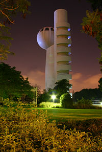
- Tel Aviv UniversityTel Aviv UniversityTel Aviv University is a public university located in Ramat Aviv, Tel Aviv, Israel. With nearly 30,000 students, TAU is Israel's largest university.-History:...
(TAU) (Tel AvivTel AvivTel Aviv , officially Tel Aviv-Yafo , is the second most populous city in Israel, with a population of 404,400 on a land area of . The city is located on the Israeli Mediterranean coastline in west-central Israel. It is the largest and most populous city in the metropolitan area of Gush Dan, with...
) – 30,000 Students - Bar-Ilan UniversityBar-Ilan UniversityBar-Ilan University is a university in Ramat Gan of the Tel Aviv District, Israel.Established in 1955, Bar Ilan is now Israel's second-largest academic institution. It has nearly 26,800 students and 1,350 faculty members...
(BIU) (Ramat Gan) – 27,000 Students - Open University of IsraelOpen University of IsraelThe Open University of Israel is a distance-education university in Israel. , the Open University taught around 39,000 students.The Open University of Israel has more students than any other academic institution in Israel. The administration is based in the city of Ra'anana. Students from all over...
(OPENU) (Ra'ananaRa'ananaRa'anana is a city in the heart of the southern Sharon Plain of the Central District of Israel with a population of 68,300, . Ra'anana is bordered by Kfar Sava on the east and Herzliya on the southwest...
) – 40,000 Students - Weizmann Institute of ScienceWeizmann Institute of ScienceThe Weizmann Institute of Science , known as Machon Weizmann, is a university and research institute in Rehovot, Israel. It differs from other Israeli universities in that it offers only graduate and post-graduate studies in the sciences....
(WIS) (RehovotRehovotRehovot is a city in the Center District of Israel, about south of Tel Aviv. According to the Israel Central Bureau of Statistics , at the end of 2009 the city had a total population of 112,700. Rehovot's official website estimates the population at 114,000.Rehovot was built on the site of Doron,...
) – 700 Students - Hebrew University of JerusalemHebrew University of JerusalemThe Hebrew University of Jerusalem ; ; abbreviated HUJI) is Israel's second-oldest university, after the Technion – Israel Institute of Technology. The Hebrew University has three campuses in Jerusalem and one in Rehovot. The world's largest Jewish studies library is located on its Edmond J...
- Based in Jerusalem Maintains a campus in RehovotRehovotRehovot is a city in the Center District of Israel, about south of Tel Aviv. According to the Israel Central Bureau of Statistics , at the end of 2009 the city had a total population of 112,700. Rehovot's official website estimates the population at 114,000.Rehovot was built on the site of Doron,...
which includes The Faculty of AgricultureAgricultureAgriculture is the cultivation of animals, plants, fungi and other life forms for food, fiber, and other products used to sustain life. Agriculture was the key implement in the rise of sedentary human civilization, whereby farming of domesticated species created food surpluses that nurtured the...
and the School of Veterinary MedicineVeterinary medicineVeterinary Medicine is the branch of science that deals with the prevention, diagnosis and treatment of disease, disorder and injury in non-human animals...
.
Colleges
- Academic Center of Law & Business http://www.clb.ac.il/english/index.html, Ramat Gan
- Academic College of Tel Aviv-Yafo
- Bezalel Academy of Art and DesignBezalel Academy of Art and DesignBezalel Academy of Art and Design is Israel's national school of art, founded in 1906 by Boris Schatz. It is named for the Biblical figure Bezalel, son of Uri , who was appointed by Moses to oversee the design and construction of the Tabernacle ....
- College of ManagementThe College of Management Academic StudiesThe College of Management Academic Studies, a college located in the city of Rishon LeZion Israel, is the largest college in Israel. Founded in 1978, COMAS is the first non-subsidized, not-for-profit academic institution in Israel to be recognized and certified by the Council for Higher Education...
(COLMAN), Rishon LeZion - Holon Institute of Technology
- Interdisciplinary CenterInterdisciplinary CenterThe Interdisciplinary Center, Herzliya is a private Israeli college located in Herzliya, Israel.The languages of instruction in the Interdisciplinary Center are Hebrew and English.-History:...
(IDC), Herzliya - Jerusalem College of TechnologyJerusalem College of TechnologyThe Jerusalem College of Technology , , is an Orthodox Jewish college. JCT's main campus are situated in the Givat Mordechai neighbourhood of Jerusalem. Other branches are located in the Givat Shaul neighbourhood of Jerusalem and Ramat Gan...
- Netanya Academic CollegeNetanya Academic CollegeNetanya Academic College is a private college based in Netanya, Israel. Established in 1994 by a team from Bar-Ilan University, it has an enrolment of around 4,000 undergraduate students...
- Netanya Academic College of Law
- Ono Academic CollegeOno Academic CollegeOno Academic College is a college located in Kiryat Ono, Israel. Ono currently is capable of granting B.A., LL.B. and M.B.A. degrees. The college has a program that serves the Ultra-orthodox population by allowing men to attend classes on different days than women...
- Sami Shamoon College of Engineering http://www.sce.ac.il
- Shenkar College of Engineering and DesignShenkar College of Engineering and DesignShenkar College of Engineering and Design is a college in Ramat Gan, Israel. Shenkar serves the Israeli industry by providing academic qualification and R&D services for modern industries....
- College of Technology Education http://www.mictec.ac.il/, Tel AvivTel AvivTel Aviv , officially Tel Aviv-Yafo , is the second most populous city in Israel, with a population of 404,400 on a land area of . The city is located on the Israeli Mediterranean coastline in west-central Israel. It is the largest and most populous city in the metropolitan area of Gush Dan, with...
- Kibbutzim College of Education http://www.smkb.ac.il/heb/, Tel Aviv
- Levinsky College of Education http://www.levinsky.ac.il/, Tel Aviv
- MofetMOFET InstituteThe MOFET Institute is a consortium of Israeli colleges of education which specializes in "research, curriculum and program development for teacher educators". It was founded by the Israel Ministry of Education in 1983, as the Institute for Curriculum Planning and Teacher Training, and took its...
, Consortium of Colleges of Education - Moreshet Yaakov Religious College of Education http://www.mor.ac.il/, RehovotRehovotRehovot is a city in the Center District of Israel, about south of Tel Aviv. According to the Israel Central Bureau of Statistics , at the end of 2009 the city had a total population of 112,700. Rehovot's official website estimates the population at 114,000.Rehovot was built on the site of Doron,...
- Ort College for Teachers of Technology http://tlv-academic.ort.org.il/, Tel Aviv
- Talpiot College of EducationTalpiot College of EducationThe Talpiot College of Education is a religious teacher training college in Tel Aviv, Israel. It prepares teachers “in the spirit of the Mamlachti dati education system”. It was founded in 1937 by Rabbi Dr...
http://www.talpiot.ac.il/, Tel Aviv
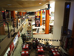
Shopping centers
Tel Aviv
Tel Aviv , officially Tel Aviv-Yafo , is the second most populous city in Israel, with a population of 404,400 on a land area of . The city is located on the Israeli Mediterranean coastline in west-central Israel. It is the largest and most populous city in the metropolitan area of Gush Dan, with...
- Carmel MarketCarmel MarketThe Carmel Market is the largest bazaar market in Tel Aviv. The market is bordered by Allenby Street and Magen David Square and the market is principally located along Carmel Street , but has expanded over time to streets such as Nahalat Binyamin Street...
- Ramat Aviv MallRamat Aviv MallRamat Aviv Mall is a shopping mall on 40 Einstein Street, in Ramat Aviv, Tel Aviv. At a rent of $1,804 per square meter, it is Israel's most expensive mall and the 35th most expensive mall in the world. Its gross leasable area is 17,800 square meters and it has 140 stores in two retail floors....
- Azrieli CenterAzrieli CenterAzrieli Center is a complex of skyscrapers in Tel Aviv. At the base of the center lies a large shopping mall. The center was originally designed by Israeli-American architect Eli Attia, and after he fell out with the developer of the center David Azrieli , completion of the design was passed on to...
- Dizengoff CenterDizengoff CenterDizengoff Center is a shopping mall at the intersection of Dizengoff Street and King George Street in Tel Aviv. The mall is named for Meir Dizengoff, the first mayor of Tel Aviv.-History:...
- Tel Aviv Central Bus StationTel Aviv Central Bus StationTel Aviv Central Bus Station, known as the New Central Bus Station , is the main bus station of Tel Aviv, Israel...
- Gan Ha'ir
- Opera Tower
- Wolfson Mall
- Tagor Mall
- London Minister Mall
- Weizmann Center
- Mikado Center
- Drugstore Center
Giv'atayim
Giv'atayim
Giv'atayim is a city in Israel east of Tel Aviv. It is part of the metropolitan area known as Gush Dan. Givatayim was established in 1922 by pioneers of the Second Aliyah. It has a population of 53,000....
- Givatayim Mall
Herzliya
Herzliya
Herzliya is a city in the central coast of Israel, at the western part of the Tel Aviv District. It has a population of 87,000 residents. Named after Theodor Herzl, the founder of modern Zionism, Herzliya covers an area of 26 km²...
- Arena Mall
- The Outlet
- Seven Stars Mall (Shivat Hakokhavim)
Ramat Gan
- Ayalon MallAyalon MallAyalon Mall is a mall in Ramat Gan, Israel. Opened in 1986, Ayalon Mall was the first mall in Israel to have a large shopping complex outside the city centre with a parking lot surrounding it...
- Marom Mall
- Dan Design Center
- Bialik Mall
Ramat HaSharon
Ramat Hasharon
Ramat HaSharon is a city located on Israel's central coastal strip in the south of the Sharon region, bordering Tel Aviv to the south and Herzliya and Kibbutz Glil Yam to the north. It is part of the Tel Aviv District, within Gush Dan metropolitan area...
- Cinema City Mall
Holon
- Holon Mall
Or Yehuda
Or Yehuda
Or Yehuda is a city in the Tel Aviv District in Israel. According to the Israel Central Bureau of Statistics , the city had a population of 32,200 at the end of 2007.-History:Or Yehuda is located where the biblical city of Kefar Ono used to stand....
- Kan-Or
Rishon LeZion
- Rothschild Center
- Kanyon Hazahav (Gold Mall)
- Shaar Rishon
- Arei Hof Mall
- G Cinema City
Netanya
Netanya
Netanya is a city in the Northern Centre District of Israel, and is the capital of the surrounding Sharon plain. It is located north of Tel Aviv, and south of Haifa between the 'Poleg' stream and Wingate Institute in the south and the 'Avichail' stream in the north.Its of beaches have made the...
- Sharon Mall
- Power Center
- Hadarim Mall
- Irusim Mall
Yehud
Yehud
Yehud is a city in the Center District in Israel that is part of the joint municipality of Yehud-Monosson. In 2007, Yehud's population was approximately 25,600 .- History :...
- Savyonim Mall
Bat Yam
- Bat Yamon
- Bat Yam Mall
Petah Tikva
Petah Tikva
Petah Tikva known as Em HaMoshavot , is a city in the Center District of Israel, east of Tel Aviv.According to the Central Bureau of Statistics, at the end of 2009, the city's population stood at 209,600. The population density is approximately...
- Ovnat Mall
- Sirkin Mall
- Em Hamoshavot Mall
Rehovot
Rehovot
Rehovot is a city in the Center District of Israel, about south of Tel Aviv. According to the Israel Central Bureau of Statistics , at the end of 2009 the city had a total population of 112,700. Rehovot's official website estimates the population at 114,000.Rehovot was built on the site of Doron,...
- American City
- Merkaz HaIr Mall
- Rehovot Mall
Ra'anana
Ra'anana
Ra'anana is a city in the heart of the southern Sharon Plain of the Central District of Israel with a population of 68,300, . Ra'anana is bordered by Kfar Sava on the east and Herzliya on the southwest...
- Renanim Mall
- Park Mall
Kfar Sava
- Arim Mall
- G Kfar Sava
Ramla
Ramla
Ramla , is a city in central Israel. The city is predominantly Jewish with a significant Arab minority. Ramla was founded circa 705–715 AD by the Umayyad Caliph Suleiman ibn Abed al-Malik after the Arab conquest of the region...
- Ramla Center
Lod
Lod
Lod is a city located on the Sharon Plain southeast of Tel Aviv in the Center District of Israel. At the end of 2010, it had a population of 70,000, roughly 75 percent Jewish and 25 percent Arab.The name is derived from the Biblical city of Lod...
- Lod Center Mall
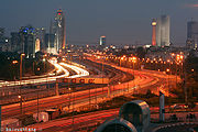
Transportation
Dan Bus Company
Dan Bus Company is an Israeli bus company based in Tel Aviv. It operates local bus service in the Tel Aviv Metropolitan Area as well as some intercity bus services between the Gush Dan area and nearby regions such as Samaria, and a connection between Bne Brak and Jerusalem. Dan operates 1,200...
is primarily focused on serving the Gush Dan, although it is being replaced by the Kavim
Kavim
Kavim is an Israeli bus company. It was founded in 2000 and provided lines in the eastern Gush Dan region - the towns/cities Kiryat Ono, Petah Tikva, Or Yehuda, Giv'atayim and others. In February 2005, Kavim expanded to the north, where it started providing bus lines in Afula, Bet She'an and the...
company in many of the Gush Dan's cities. Much of Israel's national highway network
Roads in Israel
Israel has a well-developed road network spanning the entire country. Due to the rising number of vehicles on its roadways, this network is undergoing constant improvement and expansion.- The National Roads Authority of Israel :...
feeds into the area, such as Highway 1
Highway 1 (Israel)
Highway 1 , is the main highway connecting Tel Aviv with Jerusalem.-History:The section between Latrun and Jerusalem roughly follows an ancient path connecting Jaffa and Jerusalem...
, Highway 2
Highway 2 (Israel)
Highway 2 is an Israeli highway located on the coastal plain of the Mediterranean Sea. It stretches from Tel Aviv to Haifa. The highway is also called The Coastal Highway or The New Haifa - Tel Aviv Highway ....
, Highway 4
Highway 4 (Israel)
Highway 4 is an Israeli highway that runs along Israel's entire coastal plain of the Mediterranean Sea, its route in the north runs from the Rosh HaNikra border crossing with Lebanon until the Erez Border Crossing with the Gaza Strip...
, and Highway 5
Highway 5 (Israel)
Highway 5, or the Trans-Samaria Highway , is one of Israel's main highways, connecting the Mediterranean coast immediately north of Tel Aviv with the central Sharon plain and eastwards to Ariel and other Israeli settlements in the northern West Bank, known under the biblical name Samaria.The name...
. Gush Dan is also served by the local Ayalon Highway
Ayalon Highway
Highway 20, more commonly the Ayalon Highway , is a major intracity freeway in Gush Dan, Israel. The road runs along Tel Aviv's center eastern border from north to south and connects all of the major highways leading to the city - such as Highway 4 from Ashdod and the Southern regions, Highway 2...
. Israel Railways
Israel Railways
Israel Railways is the principal passenger railway operating company in Israel, and is responsible for all inter-city and suburban rail way passenger and freight traffic in the country. All its lines are standard gauge. The network is centered in Israel's densely populated coastal plain, from...
, the state owned, national rail network provider, also feeds most traffic into or within the Gush Dan region. The Tel Aviv Light Rail, currently under construction, will also be a major feature in the regions future transport, as will thehigh speed service to Jerusalem. Two airports are located in the Gush Dan; Sde Dov Airport
Sde Dov Airport
Sde Dov Airport , also known as Dov Hoz Airport is an airport located in Tel Aviv, Israel which mainly handles scheduled domestic flights to Eilat and , northern Israel , and the Israeli Golan Heights. It is Tel Aviv's largest airport and the second largest in the area, after Ben Gurion...
located in Tel Aviv which sees an average of 700,000 passenger movements a year, is located north of the Yarkon River hosts flights to Rosh Pina, and Haifa
Haifa
Haifa is the largest city in northern Israel, and the third-largest city in the country, with a population of over 268,000. Another 300,000 people live in towns directly adjacent to the city including the cities of the Krayot, as well as, Tirat Carmel, Daliyat al-Karmel and Nesher...
in the north as well as to Ein Yahav
Ein Yahav
Ein Yahav is a moshav in Israel. Located in the northern Arava, 12km south of Hatzeva, it falls under the jurisdiction of the Central Arava Regional Council. It is named after Ein Yahav , southwest of the moshav...
, Ovda International Airport
Ovda International Airport
Ovda Airport , is a military and civilian airport in Israel, and the country's second international airport, located in the south of the country about north of the city of Eilat...
, and Eilat in the south as well as to nearby Cyprus
Cyprus
Cyprus , officially the Republic of Cyprus , is a Eurasian island country, member of the European Union, in the Eastern Mediterranean, east of Greece, south of Turkey, west of Syria and north of Egypt. It is the third largest island in the Mediterranean Sea.The earliest known human activity on the...
, Rhodes
Rhodes
Rhodes is an island in Greece, located in the eastern Aegean Sea. It is the largest of the Dodecanese islands in terms of both land area and population, with a population of 117,007, and also the island group's historical capital. Administratively the island forms a separate municipality within...
in Greece
Greece
Greece , officially the Hellenic Republic , and historically Hellas or the Republic of Greece in English, is a country in southeastern Europe....
, and Aqaba
Aqaba
Aqaba is a coastal city in the far south of Jordan, the capital of Aqaba Governorate at the head of the Gulf of Aqaba. Aqaba is strategically important to Jordan as it is the country's only seaport. Aqaba is best known today as a diving and beach resort, but industrial activity remains important...
in Jordan
Jordan
Jordan , officially the Hashemite Kingdom of Jordan , Al-Mamlaka al-Urduniyya al-Hashemiyya) is a kingdom on the East Bank of the River Jordan. The country borders Saudi Arabia to the east and south-east, Iraq to the north-east, Syria to the north and the West Bank and Israel to the west, sharing...
. Meanwhile Ben Gurion International Airport
Ben Gurion International Airport
Ben Gurion International Airport , also referred to by its Hebrew acronym Natbag , is the largest and busiest international airport in Israel, handling 12,160,339 passengers in 2010...
in Lod
Lod
Lod is a city located on the Sharon Plain southeast of Tel Aviv in the Center District of Israel. At the end of 2010, it had a population of 70,000, roughly 75 percent Jewish and 25 percent Arab.The name is derived from the Biblical city of Lod...
which is Israel
Israel
The State of Israel is a parliamentary republic located in the Middle East, along the eastern shore of the Mediterranean Sea...
's largest airport handles over 12 million passengers a year and offers flights to destinations in Europe
Europe
Europe is, by convention, one of the world's seven continents. Comprising the westernmost peninsula of Eurasia, Europe is generally 'divided' from Asia to its east by the watershed divides of the Ural and Caucasus Mountains, the Ural River, the Caspian and Black Seas, and the waterways connecting...
, Africa
Africa
Africa is the world's second largest and second most populous continent, after Asia. At about 30.2 million km² including adjacent islands, it covers 6% of the Earth's total surface area and 20.4% of the total land area...
, Asia
Asia
Asia is the world's largest and most populous continent, located primarily in the eastern and northern hemispheres. It covers 8.7% of the Earth's total surface area and with approximately 3.879 billion people, it hosts 60% of the world's current human population...
, and The Americas
Americas
The Americas, or America , are lands in the Western hemisphere, also known as the New World. In English, the plural form the Americas is often used to refer to the landmasses of North America and South America with their associated islands and regions, while the singular form America is primarily...
.
Major highways
Some of the major freeways/expressways carrying commuter traffic in and out of the Tel Aviv Metropolitan Area are:- Highway 20 (also called Ayalon Freeway) - a major intracity freeway in Gush Dan, which runs along Tel Aviv's center eastern border from north to south.
- Highway 1Highway 1 (Israel)Highway 1 , is the main highway connecting Tel Aviv with Jerusalem.-History:The section between Latrun and Jerusalem roughly follows an ancient path connecting Jaffa and Jerusalem...
- connects Tel Aviv with Jerusalem. - Highway 2Highway 2 (Israel)Highway 2 is an Israeli highway located on the coastal plain of the Mediterranean Sea. It stretches from Tel Aviv to Haifa. The highway is also called The Coastal Highway or The New Haifa - Tel Aviv Highway ....
(also called The Coastal Highway) - stretches from Tel Aviv to HaifaHaifaHaifa is the largest city in northern Israel, and the third-largest city in the country, with a population of over 268,000. Another 300,000 people live in towns directly adjacent to the city including the cities of the Krayot, as well as, Tirat Carmel, Daliyat al-Karmel and Nesher...
. It is one of the busiest highways in Israel. - Highway 4Highway 4 (Israel)Highway 4 is an Israeli highway that runs along Israel's entire coastal plain of the Mediterranean Sea, its route in the north runs from the Rosh HaNikra border crossing with Lebanon until the Erez Border Crossing with the Gaza Strip...
(also called Geha Highway, or First President Road - a major North-South highway connecting Ra'ananaRa'ananaRa'anana is a city in the heart of the southern Sharon Plain of the Central District of Israel with a population of 68,300, . Ra'anana is bordered by Kfar Sava on the east and Herzliya on the southwest...
and Kfar SabaKfar SabaKfar Saba , officially Kfar Sava, is a city in the Sharon region, of the Center District of Israel. At the end of 2009, Kfar Saba had a total population of 83,600.-History:...
in the North to Petah Tiqva and Ramat Gan in the centre and Ashdod in the South. - Highway 5Highway 5 (Israel)Highway 5, or the Trans-Samaria Highway , is one of Israel's main highways, connecting the Mediterranean coast immediately north of Tel Aviv with the central Sharon plain and eastwards to Ariel and other Israeli settlements in the northern West Bank, known under the biblical name Samaria.The name...
- connects the MediterraneanMediterranean SeaThe Mediterranean Sea is a sea connected to the Atlantic Ocean surrounded by the Mediterranean region and almost completely enclosed by land: on the north by Anatolia and Europe, on the south by North Africa, and on the east by the Levant...
coast immediately north of Tel AvivTel AvivTel Aviv , officially Tel Aviv-Yafo , is the second most populous city in Israel, with a population of 404,400 on a land area of . The city is located on the Israeli Mediterranean coastline in west-central Israel. It is the largest and most populous city in the metropolitan area of Gush Dan, with...
with the central Sharon plain and ArielAriel (city)Ariel is an Israeli settlement and a city in the West Bank. Ariel was established in 1978. Its population at the end of 2009 was 17,600, including 7,000 immigrants who came to Israel after 1990. It is the fourth largest Jewish settlement city in the West Bank., after Modi'in Illit, Beitar Illit,...
and other Israeli settlementIsraeli settlementAn Israeli settlement is a Jewish civilian community built on land that was captured by Israel from Jordan, Egypt, and Syria during the 1967 Six-Day War and is considered occupied territory by the international community. Such settlements currently exist in the West Bank...
s in the northern West BankWest BankThe West Bank ) of the Jordan River is the landlocked geographical eastern part of the Palestinian territories located in Western Asia. To the west, north, and south, the West Bank shares borders with the state of Israel. To the east, across the Jordan River, lies the Hashemite Kingdom of Jordan...
. - Highway 44Highway 44 (Israel)Highway 44 is a highway in central Israel. It connects Tel Aviv-Yafo to Ramla, Lod and the Shefela. It begins in Tel Aviv in the north and ends at Nachshon and Shimshon junction near Beit Shemesh in the south....
- connects Tel Aviv with RamlaRamlaRamla , is a city in central Israel. The city is predominantly Jewish with a significant Arab minority. Ramla was founded circa 705–715 AD by the Umayyad Caliph Suleiman ibn Abed al-Malik after the Arab conquest of the region...
, LodLodLod is a city located on the Sharon Plain southeast of Tel Aviv in the Center District of Israel. At the end of 2010, it had a population of 70,000, roughly 75 percent Jewish and 25 percent Arab.The name is derived from the Biblical city of Lod...
and the Shefela. - Highway 6Highway 6 (Israel)Highway 6 , widely known as the Trans-Israel Highway or Cross-Israel Highway , is a major electronic toll highway in Israel. The highway was officially dedicated as the Yitzhak Rabin Highway , though this name is not commonly used. It started operating in the early 2000s and is being lengthened as...
- a new North-South tollway running east of Gush Dan from GalileeGalileeGalilee , is a large region in northern Israel which overlaps with much of the administrative North District of the country. Traditionally divided into Upper Galilee , Lower Galilee , and Western Galilee , extending from Dan to the north, at the base of Mount Hermon, along Mount Lebanon to the...
in the north to Beer Sheva in the south.