

Jordan Rift Valley
Encyclopedia
Israel
The State of Israel is a parliamentary republic located in the Middle East, along the eastern shore of the Mediterranean Sea...
, Jordan
Jordan
Jordan , officially the Hashemite Kingdom of Jordan , Al-Mamlaka al-Urduniyya al-Hashemiyya) is a kingdom on the East Bank of the River Jordan. The country borders Saudi Arabia to the east and south-east, Iraq to the north-east, Syria to the north and the West Bank and Israel to the west, sharing...
and the Palestinian territories
Palestinian territories
The Palestinian territories comprise the West Bank and the Gaza Strip. Since the Palestinian Declaration of Independence in 1988, the region is today recognized by three-quarters of the world's countries as the State of Palestine or simply Palestine, although this status is not recognized by the...
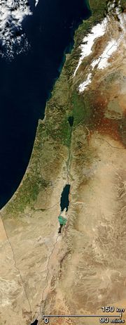
. This geographic region includes the Jordan River, Jordan Valley
Jordan Valley (Middle East)
The Jordan Valley forms part of the larger Jordan Rift Valley. It is 120 kilometers long and 15 kilometers wide, where it runs from Lake Tiberias in the north to northern Dead Sea in the south. It runs for an additional 155 kilometer south of the Dead Sea to Aqaba, an area also known as Wadi...
, Hula Valley, Lake Tiberias and the Dead Sea
Dead Sea
The Dead Sea , also called the Salt Sea, is a salt lake bordering Jordan to the east and Israel and the West Bank to the west. Its surface and shores are below sea level, the lowest elevation on the Earth's surface. The Dead Sea is deep, the deepest hypersaline lake in the world...
, the lowest land elevation on Earth. The valley continues to the Red Sea
Red Sea
The Red Sea is a seawater inlet of the Indian Ocean, lying between Africa and Asia. The connection to the ocean is in the south through the Bab el Mandeb strait and the Gulf of Aden. In the north, there is the Sinai Peninsula, the Gulf of Aqaba, and the Gulf of Suez...
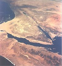
, incorporating Arabah
Arabah
The Arabah , also known as Aravah, is a section of the Great Rift Valley running in a north-south orientation between the southern end of the Sea of Galilee down to the Dead Sea and continuing further south where it ends at the Gulf of Aqaba. It includes most of the border between Israel to the...
and the shorelines of the Gulf of Aqaba
Gulf of Aqaba
The Gulf of Aqaba is a large gulf located at the northern tip of the Red Sea. In pre twentieth-century and modern sources it is often named the Gulf of Eilat, as Eilat is its predominant Israeli city ....
.
Origins and physical features
Miocene
The Miocene is a geological epoch of the Neogene Period and extends from about . The Miocene was named by Sir Charles Lyell. Its name comes from the Greek words and and means "less recent" because it has 18% fewer modern sea invertebrates than the Pliocene. The Miocene follows the Oligocene...
epoch (23.8 - 5.3 Myr ago) when the Arabian tectonic plate
Arabian Plate
The Arabian Plate is one of three tectonic plates which have been moving northward over millions of years and colliding with the Eurasian Plate...
moved northward and then eastward away from Africa. One million years later, the land between the Mediterranean and the Jordan Rift Valley rose so that the sea water stopped flooding the area.
The lowest point in the Jordan Rift Valley is at the shores of the Dead Sea, which is also the lowest point (on land) on the surface of the earth at 400 meters below sea level. Rising sharply to almost 1,000 meters in the west, and similarly in the east, the rift is a significant topographic feature over which few narrow paved roads and difficult mountain tracks lead. The valley north of the Dead Sea has long been a site of agriculture because of water available from the Jordan River and numerous springs located on the valley's flanks.
The Dead Sea Transform
The plate boundary which extends through the valley is variously called the Dead Sea TransformDead Sea Transform
The Dead Sea Transform fault system, also sometimes referred to as the Dead Sea Rift, is a geologic fault which runs from the Maras Triple Junction to the northern end of the Red Sea Rift...
or Dead Sea Rift. The boundary separates the Arabian plate
Arabian Plate
The Arabian Plate is one of three tectonic plates which have been moving northward over millions of years and colliding with the Eurasian Plate...
from the African plate
African Plate
The African Plate is a tectonic plate which includes the continent of Africa, as well as oceanic crust which lies between the continent and various surrounding ocean ridges.-Boundaries:...
, connecting the divergent plate boundary in the Red Sea
Red Sea
The Red Sea is a seawater inlet of the Indian Ocean, lying between Africa and Asia. The connection to the ocean is in the south through the Bab el Mandeb strait and the Gulf of Aden. In the north, there is the Sinai Peninsula, the Gulf of Aqaba, and the Gulf of Suez...
(the Red Sea Rift
Red Sea Rift
The Red Sea Rift is a spreading center between two tectonic plates, the African Plate and the Arabian Plate. It extends down the length of the Red Sea, stretching from the southern end of the Dead Sea Transform to a triple junction with the Aden Ridge and the East African Rift in the Afar...
) to the East Anatolian Fault
East Anatolian Fault
The East Anatolian Fault is a major strike-slip fault zone in eastern Turkey. It forms the transform type tectonic boundary between the Anatolian Plate and the northward-moving Arabian Plate. The difference in the relative motions of the two plates is manifest in the left lateral motion along the...
in Turkey
Turkey
Turkey , known officially as the Republic of Turkey , is a Eurasian country located in Western Asia and in East Thrace in Southeastern Europe...
.
The interpretation of the tectonic regime that led to the development of the Dead Sea Transform is highly contested. Some consider it as a transform fault that accommodates a 105 km northwards displacement of the Arabian plate
Arabian Plate
The Arabian Plate is one of three tectonic plates which have been moving northward over millions of years and colliding with the Eurasian Plate...
, and trace its structural evolution to the early Miocene
Miocene
The Miocene is a geological epoch of the Neogene Period and extends from about . The Miocene was named by Sir Charles Lyell. Its name comes from the Greek words and and means "less recent" because it has 18% fewer modern sea invertebrates than the Pliocene. The Miocene follows the Oligocene...
. Others presume that the Rift is an incipient oceanic spreading center, the northern extension of the Red Sea Rift
Red Sea Rift
The Red Sea Rift is a spreading center between two tectonic plates, the African Plate and the Arabian Plate. It extends down the length of the Red Sea, stretching from the southern end of the Dead Sea Transform to a triple junction with the Aden Ridge and the East African Rift in the Afar...
, and the displacement along it is oblique, with approximately 10–15 km of extension in addition to the more substantial left lateral (sinistral) strike-slip. The evolution of the rift, according to this latter model, started in the late Miocene with the linear series of basins that propagated gradually along their axes to form the present rift valley. The elucidation of the nature of the Dead Sea Transform/Rift is a matter of ongoing study and discussion.
Population
The Jordanian population of the valley is over 85,000 people, most of whom are farmers, and 80% of the farms in the Jordanian part of the valley are family farms no larger than 30 dunamDunam
A dunam or dönüm, dunum, donum, dynym, dulum was a non-SI unit of land area used in the Ottoman Empire and representing the amount of land that can be plowed in a day; its value varied from 900–2500 m²...
s (3 ha, 7.4 ac).
Some 47,000 Palestinians live in the part of the valley that lies in the West Bank in about twenty permanent communities, most of them reside in the city of Jericho
Jericho
Jericho ; is a city located near the Jordan River in the West Bank of the Palestinian territories. It is the capital of the Jericho Governorate and has a population of more than 20,000. Situated well below sea level on an east-west route north of the Dead Sea, Jericho is the lowest permanently...
. Thousands of Bedouins also live in temporary communities.
About 11,000 Israelis live in 17 kibbutzim that form part of the Emek HaYarden Regional Council
Emek Hayarden Regional Council
The Emek HaYarden Regional Council , is a regional council in the Jordan River Valley between the Sea of Galilee in the north and Beit She'an in the south. It was the first regional council in Israel, formed in 1949....
in Israel, while an additional 7,500 live in twenty-six Israeli settlements and five Nahal
Nahal
Nahal is an Israel Defense Forces infantry brigade. Historically, it refers to a program that combines military service and establishment of new agricultural settlements, often in outlying areas...
encampments that have been established in the part of the Jordan Valley that lies in the West Bank.
Prior to the 1967 Six-Day War
Six-Day War
The Six-Day War , also known as the June War, 1967 Arab-Israeli War, or Third Arab-Israeli War, was fought between June 5 and 10, 1967, by Israel and the neighboring states of Egypt , Jordan, and Syria...
, the valley's Jordanian side was home to about 60,000 people largely engaged in agriculture and pastoralism. By 1971, the population had declined to 5,000 as a result of the war and the 1970-71 conflict between the Palestinian guerrillas and the Jordanian armed forces
Black September in Jordan
September 1970 is known as the Black September in Arab history and sometimes is referred to as the "era of regrettable events." It was a month when Hashemite King Hussein of Jordan moved to quash the militancy of Palestinian organizations and restore his monarchy's rule over the country. The...
. Investments by the Jordanian government in the region allowed the population to rebound to over 85,000 by 1979.
Since the end of the 1967 war, every Israeli government has considered the western Jordan Valley to be the eastern border
Allon Plan
The Allon Plan was an Israeli proposal of the late 1960s to partition the West Bank, captured from Jordan in the Six-Day War of June 1967, between Israel and Jordan...
of Israel
Israel
The State of Israel is a parliamentary republic located in the Middle East, along the eastern shore of the Mediterranean Sea...
with Jordan
Jordan
Jordan , officially the Hashemite Kingdom of Jordan , Al-Mamlaka al-Urduniyya al-Hashemiyya) is a kingdom on the East Bank of the River Jordan. The country borders Saudi Arabia to the east and south-east, Iraq to the north-east, Syria to the north and the West Bank and Israel to the west, sharing...
.
The 1994 peace treaty between Israel
Israel
The State of Israel is a parliamentary republic located in the Middle East, along the eastern shore of the Mediterranean Sea...
and Jordan
Jordan
Jordan , officially the Hashemite Kingdom of Jordan , Al-Mamlaka al-Urduniyya al-Hashemiyya) is a kingdom on the East Bank of the River Jordan. The country borders Saudi Arabia to the east and south-east, Iraq to the north-east, Syria to the north and the West Bank and Israel to the west, sharing...
defines the international border between the countries on the Jordan river in the center of the Jordan valley.
Agriculture
The Jordan River rises from several sources, mainly the Anti-Lebanon Mountains in SyriaSyria
Syria , officially the Syrian Arab Republic , is a country in Western Asia, bordering Lebanon and the Mediterranean Sea to the West, Turkey to the north, Iraq to the east, Jordan to the south, and Israel to the southwest....
. It flows down into the Sea of Galilee
Sea of Galilee
The Sea of Galilee, also Kinneret, Lake of Gennesaret, or Lake Tiberias , is the largest freshwater lake in Israel, and it is approximately in circumference, about long, and wide. The lake has a total area of , and a maximum depth of approximately 43 m...
, 212 meters below sea level, and then drains into the Dead Sea
Dead Sea
The Dead Sea , also called the Salt Sea, is a salt lake bordering Jordan to the east and Israel and the West Bank to the west. Its surface and shores are below sea level, the lowest elevation on the Earth's surface. The Dead Sea is deep, the deepest hypersaline lake in the world...
. South of the Dead Sea, the Jordan Valley turns into the hot, dry Arabah
Arabah
The Arabah , also known as Aravah, is a section of the Great Rift Valley running in a north-south orientation between the southern end of the Sea of Galilee down to the Dead Sea and continuing further south where it ends at the Gulf of Aqaba. It includes most of the border between Israel to the...
valley.
The Jordan Valley is several degrees warmer than adjacent areas, and its year-round agricultural climate, fertile soils and water supply made it a site for agriculture dating to about 10,000 years ago. By about 3000 BCE, produce from the valley was being exported to neighboring regions. The area's fertile lands were chronicled in the Hebrew Bible
Hebrew Bible
The Hebrew Bible is a term used by biblical scholars outside of Judaism to refer to the Tanakh , a canonical collection of Jewish texts, and the common textual antecedent of the several canonical editions of the Christian Old Testament...
, where it was the site of several miracles for the people of Israel
Israel
The State of Israel is a parliamentary republic located in the Middle East, along the eastern shore of the Mediterranean Sea...
, such as the Jordan River stopping its flow to allow the Jewish people, led by the Ark of the Covenant
Ark of the Covenant
The Ark of the Covenant , also known as the Ark of the Testimony, is a chest described in Book of Exodus as solely containing the Tablets of Stone on which the Ten Commandments were inscribed...
, to pass over. The Jordan River is revered by Christians as the place where John the Baptist
John the Baptist
John the Baptist was an itinerant preacher and a major religious figure mentioned in the Canonical gospels. He is described in the Gospel of Luke as a relative of Jesus, who led a movement of baptism at the Jordan River...
baptized Jesus Christ.
In the last few decades, modern methods of farming have vastly expanded the agricultural output of the area. The construction of the East Ghor Canal
East Ghor Main Canal
The King Abdullah Canal is the largest irrigation canal system in Jordan and runs parallel to the east bank of the Jordan River. It was previously known as the East Ghor Main Canal and renamed in 1987 after Abdullah I of Jordan....
by Jordan in 1950s (now known as the King Abdullah Canal), which runs down the east bank of the Jordan Valley for 69 kilometers, has brought new areas under irrigation. The introduction of portable greenhouses has brought about a sevenfold increase in productivity, allowing Jordan to export large amounts of fruit and vegetables year-round.