
Karst topography
Encyclopedia
Solvation
Solvation, also sometimes called dissolution, is the process of attraction and association of molecules of a solvent with molecules or ions of a solute...
of a layer or layers of soluble bedrock
Bedrock
In stratigraphy, bedrock is the native consolidated rock underlying the surface of a terrestrial planet, usually the Earth. Above the bedrock is usually an area of broken and weathered unconsolidated rock in the basal subsoil...
, usually carbonate rock
Carbonate rock
Carbonate rocks are a class of sedimentary rocks composed primarily of carbonate minerals. The two major types are limestone, which is composed of calcite or aragonite and dolostone, which is composed of the mineral dolomite .Calcite can be either dissolved by groundwater or precipitated by...
such as limestone
Limestone
Limestone is a sedimentary rock composed largely of the minerals calcite and aragonite, which are different crystal forms of calcium carbonate . Many limestones are composed from skeletal fragments of marine organisms such as coral or foraminifera....
or dolomite
Dolomite
Dolomite is a carbonate mineral composed of calcium magnesium carbonate CaMg2. The term is also used to describe the sedimentary carbonate rock dolostone....
, but has also been documented for weathering
Weathering
Weathering is the breaking down of rocks, soils and minerals as well as artificial materials through contact with the Earth's atmosphere, biota and waters...
resistant rocks like quartzite
Quartzite
Quartzite is a hard metamorphic rock which was originally sandstone. Sandstone is converted into quartzite through heating and pressure usually related to tectonic compression within orogenic belts. Pure quartzite is usually white to gray, though quartzites often occur in various shades of pink...
given the right conditions.
Due to subterranean drainage, there may be very limited surface water, even to the absence of all rivers and lakes. Many karst regions display distinctive surface features, with cenote
Cenote
A cenote is a deep natural pit, or sinkhole, characteristic of Mexico and Central America, resulting from the collapse of limestone bedrock that exposes groundwater underneath...
s, sinkhole
Sinkhole
A sinkhole, also known as a sink, shake hole, swallow hole, swallet, doline or cenote, is a natural depression or hole in the Earth's surface caused by karst processes — the chemical dissolution of carbonate rocks or suffosion processes for example in sandstone...
s or dolines being the most common. However, distinctive karst surface features may be completely absent where the soluble rock is mantled, such as by glacial debris, or confined by a superimposed non-soluble rock strata. Some karst regions include thousands of cave
Cave
A cave or cavern is a natural underground space large enough for a human to enter. The term applies to natural cavities some part of which is in total darkness. The word cave also includes smaller spaces like rock shelters, sea caves, and grottos.Speleology is the science of exploration and study...
s, even though evidence of caves that are big enough for human exploration is not a required characteristic of karst.
Background
Karst topography is characterized by subterranean limestone caverns, carved by groundwater. The geographerGeographer
A geographer is a scholar whose area of study is geography, the study of Earth's natural environment and human society.Although geographers are historically known as people who make maps, map making is actually the field of study of cartography, a subset of geography...
Jovan Cvijić
Jovan Cvijic
Jovan Cvijić was a Serbian geographer, president of the Serbian Royal Academy of Sciences, and rector of the University of Belgrade. A world-renowned scientist, Cvijić is considered the founder of geography in Serbia.-Early life and family:Jovan Cvijić was born on October 11 Jovan Cvijić...
(1865–1927) was born in western Serbia
Serbia
Serbia , officially the Republic of Serbia , is a landlocked country located at the crossroads of Central and Southeast Europe, covering the southern part of the Carpathian basin and the central part of the Balkans...
and studied widely in the Dinaric Kras
Kras
Karst ; also known as the Karst Plateau, is a limestone borderline plateau region extending in southwestern Slovenia and northeastern Italy. It lies between the Vipava Valley, the low hills surrounding the valley, the westernmost part of the Brkini Hills, northern Istria, and the Gulf of Trieste...
region. His publication of Das Karstphänomen (1893) established that rock dissolution was the key process and that it created most types of dolines
Sinkhole
A sinkhole, also known as a sink, shake hole, swallow hole, swallet, doline or cenote, is a natural depression or hole in the Earth's surface caused by karst processes — the chemical dissolution of carbonate rocks or suffosion processes for example in sandstone...
, "the diagnostic karst landforms". The Dinaric Kras thus became the type area for dissolutional landforms and aquifers; the regional name kras, Germanicised as "karst", is now applied to modern and paleo-dissolutional phenomena worldwide. Cvijić related the complex behaviour of karst aquifers to development of solutional conduit networks and linked it to a cycle of landform evolution. Cvijić defined two main types of karst area, holokarst, wholly developed, as in the Dinaric region along the eastern Adriatic and deeper inland in the Balkan Peninsula and merokarst, imperfectly developed with some karst forms, as in eastern Serbia
Serbia
Serbia , officially the Republic of Serbia , is a landlocked country located at the crossroads of Central and Southeast Europe, covering the southern part of the Carpathian basin and the central part of the Balkans...
. Cvijić is recognized as "the father of karst geomorphology".
The international community has settled on karst, the German
German language
German is a West Germanic language, related to and classified alongside English and Dutch. With an estimated 90 – 98 million native speakers, German is one of the world's major languages and is the most widely-spoken first language in the European Union....
name for Kras
Kras
Karst ; also known as the Karst Plateau, is a limestone borderline plateau region extending in southwestern Slovenia and northeastern Italy. It lies between the Vipava Valley, the low hills surrounding the valley, the westernmost part of the Brkini Hills, northern Istria, and the Gulf of Trieste...
, a region in Slovenia
Slovenia
Slovenia , officially the Republic of Slovenia , is a country in Central and Southeastern Europe touching the Alps and bordering the Mediterranean. Slovenia borders Italy to the west, Croatia to the south and east, Hungary to the northeast, and Austria to the north, and also has a small portion of...
partially extending into Italy
Italy
Italy , officially the Italian Republic languages]] under the European Charter for Regional or Minority Languages. In each of these, Italy's official name is as follows:;;;;;;;;), is a unitary parliamentary republic in South-Central Europe. To the north it borders France, Switzerland, Austria and...
, where it is called "Carso" and where the first scientific research of a karst topography was made. The name has an Indo-European
Indo-European
Indo-European may refer to:* Indo-European languages** Aryan race, a 19th century and early 20th century term for those peoples who are the native speakers of Indo-European languages...
origin (from karra meaning "stone"), and in antiquity it was called "Carusardius" in Latin. The Slovene form grast is attested since 1177, and the Croatian
Croatian language
Croatian is the collective name for the standard language and dialects spoken by Croats, principally in Croatia, Bosnia and Herzegovina, the Serbian province of Vojvodina and other neighbouring countries...
kras since 1230.. "Krš" – "Krsh" meaning in Croatian and in Serbian "barren land" which is typical feature in the Northern Dinaric limestone mountains could also be an origin to the word Karst.
Chemistry
Acid
An acid is a substance which reacts with a base. Commonly, acids can be identified as tasting sour, reacting with metals such as calcium, and bases like sodium carbonate. Aqueous acids have a pH of less than 7, where an acid of lower pH is typically stronger, and turn blue litmus paper red...
ic water acting on weakly soluble bedrock
Bedrock
In stratigraphy, bedrock is the native consolidated rock underlying the surface of a terrestrial planet, usually the Earth. Above the bedrock is usually an area of broken and weathered unconsolidated rock in the basal subsoil...
such as limestone
Limestone
Limestone is a sedimentary rock composed largely of the minerals calcite and aragonite, which are different crystal forms of calcium carbonate . Many limestones are composed from skeletal fragments of marine organisms such as coral or foraminifera....
or dolostone
Dolostone
Dolostone or dolomite rock is a sedimentary carbonate rock that contains a high percentage of the mineral dolomite. In old U.S.G.S. publications it was referred to as magnesian limestone. Most dolostone formed as a magnesium replacement of limestone or lime mud prior to lithification. It is...
. The mildly acidic water begins to dissolve
Weathering
Weathering is the breaking down of rocks, soils and minerals as well as artificial materials through contact with the Earth's atmosphere, biota and waters...
the surface along fractures or bedding planes in the limestone bedrock. Over time, these fractures enlarge as the bedrock continues to dissolve. Openings in the rock increase in size, and an underground drainage system begins to develop, allowing more water to pass through the area, and accelerating the formation of underground karst features.
Main dissolution mechanism: carbonic acid
The carbonic acidCarbonic acid
Carbonic acid is the inorganic compound with the formula H2CO3 . It is also a name sometimes given to solutions of carbon dioxide in water, because such solutions contain small amounts of H2CO3. Carbonic acid forms two kinds of salts, the carbonates and the bicarbonates...
that causes these features is formed as rain passes through the atmosphere
Earth's atmosphere
The atmosphere of Earth is a layer of gases surrounding the planet Earth that is retained by Earth's gravity. The atmosphere protects life on Earth by absorbing ultraviolet solar radiation, warming the surface through heat retention , and reducing temperature extremes between day and night...
picking up CO2
Carbon dioxide
Carbon dioxide is a naturally occurring chemical compound composed of two oxygen atoms covalently bonded to a single carbon atom...
, which dissolves in the water. Once the rain reaches the ground, it may pass through soil
Soil
Soil is a natural body consisting of layers of mineral constituents of variable thicknesses, which differ from the parent materials in their morphological, physical, chemical, and mineralogical characteristics...
that can provide much more CO2 to form a weak carbonic acid
Carbonic acid
Carbonic acid is the inorganic compound with the formula H2CO3 . It is also a name sometimes given to solutions of carbon dioxide in water, because such solutions contain small amounts of H2CO3. Carbonic acid forms two kinds of salts, the carbonates and the bicarbonates...
solution, which dissolves calcium carbonate
Calcium carbonate
Calcium carbonate is a chemical compound with the formula CaCO3. It is a common substance found in rocks in all parts of the world, and is the main component of shells of marine organisms, snails, coal balls, pearls, and eggshells. Calcium carbonate is the active ingredient in agricultural lime,...
. The sequence of reactions involved in the limestone dissolution are the following:
- H2O + CO2 → H2CO3
- CaCO3 → Ca2+ + CO32–
- CO32– + H2CO3 → 2 HCO3–
- CaCO3 + H2CO3 → Ca2+ + 2 HCO3–
This is the main dissolution mechanism of calcium carbonate in limestone.
Secondary dissolution mechanism: sulfide oxidation
However, in particular and very rare conditions such as these encountered in the past in Lechuguilla CaveLechuguilla Cave
Lechuguilla Cave is, as of June 2011, the sixth longest cave known to exist in the world, and the deepest in the continental United States , but it is most famous for its unusual geology, rare formations, and pristine condition....
in New Mexico
New Mexico
New Mexico is a state located in the southwest and western regions of the United States. New Mexico is also usually considered one of the Mountain States. With a population density of 16 per square mile, New Mexico is the sixth-most sparsely inhabited U.S...
(and more recently in the Frasassi Caves
Frasassi Caves
The Frasassi Caves are a remarkable karst cave system in the municipality of Genga, Italy, in the province of Ancona, Marche...
in Italy), other mechanisms may also play a role. The oxidation of sulfide
Sulfide
A sulfide is an anion of sulfur in its lowest oxidation state of 2-. Sulfide is also a slightly archaic term for thioethers, a common type of organosulfur compound that are well known for their bad odors.- Properties :...
s leading to the formation of sulfuric acid
Sulfuric acid
Sulfuric acid is a strong mineral acid with the molecular formula . Its historical name is oil of vitriol. Pure sulfuric acid is a highly corrosive, colorless, viscous liquid. The salts of sulfuric acid are called sulfates...
can also be one of the corrosion factors in karst formation. As O2-rich surface waters seep into deep anoxic karst systems it brings oxygen which reacts with sulfide present in the system (pyrite
Pyrite
The mineral pyrite, or iron pyrite, is an iron sulfide with the formula FeS2. This mineral's metallic luster and pale-to-normal, brass-yellow hue have earned it the nickname fool's gold because of its resemblance to gold...
or H2S) to form sulfuric acid (H2SO4). Sulfuric acid then reacts with calcium carbonate causing an increased erosion within the limestone formation. This can be summarized by the cascade of the following reactions:
- H2S + 2 O2 → H2SO4 (sulfide oxidation)
- H2SO4 + 2 H2O → SO42– + 2 H3O+ (sulfuric acid dissociation)
- CaCO3 + 2 H3O+ → Ca2+ + H2CO3 + 2 H2O (calcium carbonate dissolution)
- CaCO3 + H2SO4 → CaSO4 + H2CO3 (global reaction leading to calcium sulfate)
- CaSO4 + 2 H2O → CaSO4 · 2 H2O (hydration and gypsumGypsumGypsum is a very soft sulfate mineral composed of calcium sulfate dihydrate, with the chemical formula CaSO4·2H2O. It is found in alabaster, a decorative stone used in Ancient Egypt. It is the second softest mineral on the Mohs Hardness Scale...
formation)
As a result of this reaction the mineral gypsum forms.
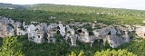
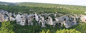
Morphology
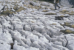
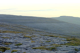
Limestone pavement
A limestone pavement is a natural karst landform consisting of a flat, incised surface of exposed limestone that resembles an artificial pavement. The term is mainly used in the UK where many of these landforms have developed distinctive surface patterning resembling block of paving...
, collectively called karren or lapiez. Medium-sized surface features may include sinkhole
Sinkhole
A sinkhole, also known as a sink, shake hole, swallow hole, swallet, doline or cenote, is a natural depression or hole in the Earth's surface caused by karst processes — the chemical dissolution of carbonate rocks or suffosion processes for example in sandstone...
s or cenote
Cenote
A cenote is a deep natural pit, or sinkhole, characteristic of Mexico and Central America, resulting from the collapse of limestone bedrock that exposes groundwater underneath...
s (closed basins), vertical shafts, foibe (inverted funnel shaped sinkholes), disappearing streams, and reappearing spring
Spring (hydrosphere)
A spring—also known as a rising or resurgence—is a component of the hydrosphere. Specifically, it is any natural situation where water flows to the surface of the earth from underground...
s. Large-scale features may include limestone pavement
Limestone pavement
A limestone pavement is a natural karst landform consisting of a flat, incised surface of exposed limestone that resembles an artificial pavement. The term is mainly used in the UK where many of these landforms have developed distinctive surface patterning resembling block of paving...
s, polje
Polje
A polje is a large flat plain in karst territory, with areas usually 5 to 400 km². The name derives from the Slavic languages and is a cognate with the English word field.-In geology:...
s and blind valleys. Mature karst landscapes, where more bedrock has been removed than remains, may result in karst towers, or haystack/eggbox
Mogote
Mogotes are isolated, steep-sided, residual, hills, which are composed of either limestone, marble, or dolomite and surrounded by nearly flat alluvial plains. These hills typically have a rounded, tower-like form. This term was originally used for karst hills developed in the folded limestone in...
landscapes. Beneath the surface, complex underground drainage systems (such as karst aquifer
Aquifer
An aquifer is a wet underground layer of water-bearing permeable rock or unconsolidated materials from which groundwater can be usefully extracted using a water well. The study of water flow in aquifers and the characterization of aquifers is called hydrogeology...
s) and extensive cave
Cave
A cave or cavern is a natural underground space large enough for a human to enter. The term applies to natural cavities some part of which is in total darkness. The word cave also includes smaller spaces like rock shelters, sea caves, and grottos.Speleology is the science of exploration and study...
s and cavern systems may form.
Tropics
The tropics is a region of the Earth surrounding the Equator. It is limited in latitude by the Tropic of Cancer in the northern hemisphere at approximately N and the Tropic of Capricorn in the southern hemisphere at S; these latitudes correspond to the axial tilt of the Earth...
, produces karst topography that includes a sharp makatea
Makatea
Makatea, or Mangaia-te-vai-tamae, is a raised coral atoll in the northwestern part of the Tuamotus. It is located 79 km southwest from Rangiroa to the west of the Palliser group. It is surrounded by spectacular cliffs, rising to a plateau 80 meters above the sea level. This island is...
surface above the normal reach of the sea and undercuts that are mostly the result of biological activity or bioerosion
Bioerosion
Bioerosion describes the erosion of hard ocean substrates – and less often terrestrial substrates – by living organisms. Marine bioerosion can be caused by mollusks, polychaete worms, phoronids, sponges, crustaceans, echinoids, and fish; it can occur on coastlines, on coral reefs, and...
at or a little above mean sea level. Some of the most dramatic of these formations can be seen in Thailand's Phangnga Bay and Halong Bay
Halong Bay
Ha Long Bay is a UNESCO World Heritage Site, and a popular travel destination, located in Quang Ninh province, Vietnam. Administratively, the bay belongs to Hạ Long City, Cẩm Phả town, and part of Van Don district. The bay features thousands of limestone karsts and isles in various sizes and shapes...
in Vietnam
Vietnam
Vietnam – sometimes spelled Viet Nam , officially the Socialist Republic of Vietnam – is the easternmost country on the Indochina Peninsula in Southeast Asia. It is bordered by China to the north, Laos to the northwest, Cambodia to the southwest, and the South China Sea –...
.
Calcium carbonate dissolved into water may precipitate out where the water discharges some of its dissolved carbon dioxide. Rivers which emerge from springs may produce tufa
Tufa
Tufa is a variety of limestone, formed by the precipitation of carbonate minerals from ambient temperature water bodies. Geothermally heated hot-springs sometimes produce similar carbonate deposits known as travertine...
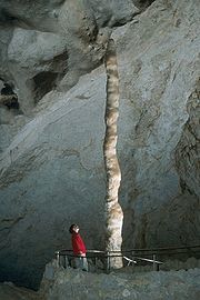
terraces, consisting of layers of calcite deposited over extended periods of time. In caves, a variety of features collectively called speleothems are formed by deposition of calcium carbonate and other dissolved minerals.
Hydrology
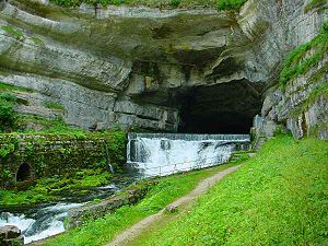
A karst fenster
Karst fenster
Karst fenster is a geomorphic feature formed from the dissolution of carbonate bedrock where a spring emerges then the discharge abruptly disappears into a sinkhole...
is where an underground stream emerges onto the surface between layers of rock, cascades some feet, and then disappears back down, often into a sinkhole
Sinkhole
A sinkhole, also known as a sink, shake hole, swallow hole, swallet, doline or cenote, is a natural depression or hole in the Earth's surface caused by karst processes — the chemical dissolution of carbonate rocks or suffosion processes for example in sandstone...
. Rivers in karst areas may disappear underground a number of times and spring up again in different places, usually under a different name (like Ljubljanica
Ljubljanica
The Ljubljanica is a river in the southern part of Ljubljana Basin in Slovenia. The capital of Slovenia, Ljubljana, is situated on the river. The Ljubljanica rises to the south of the town Vrhnika and outflows in the Sava River about downstream from Ljubljana. Its largest affluent is Mali graben....
, the river of seven names). An example of this is the Popo Agie River
Popo Agie Wilderness
Popo Agie Wilderness is located within Shoshone National Forest, Wyoming, United States. The wilderness consists of 101,870 acres on the east side of the continental divide in the Wind River Range. Originally set aside as a primitive area in 1932, in 1984 the Wyoming Wilderness Act was passed...
in Fremont County, Wyoming. At a site simply named "The Sinks" in Sinks Canyon State Park
Sinks Canyon State Park
Sinks Canyon State Park is a Wyoming state park located in the Wind River Mountains, 6 miles southwest of Lander, Wyoming on Wyoming Highway 131. The park is named for a portion of the Middle Fork of the Popo Agie River...
, the river flows into a cave in a formation known as the Madison Limestone, and then rises again a half-mile down the canyon in a placid pool. A Turlough
Turlough (lake)
A turlough, or turlach, is a unique type of disappearing lake found mostly in limestone areas of Ireland, west of the River Shannon. The name comes from the Irish "tuar", meaning dry, with the suffix "lach", meaning a place . The "lach" suffix is often mistakenly spelled and/or thought to refer to...
is a unique type of seasonal lake found in Irish karst areas which are formed through the annual welling-up of water from the underground water system.
Water supplies from wells
Water well
A water well is an excavation or structure created in the ground by digging, driving, boring or drilling to access groundwater in underground aquifers. The well water is drawn by an electric submersible pump, a trash pump, a vertical turbine pump, a handpump or a mechanical pump...
in karst topography may be unsafe, as the water may have run unimpeded from a sinkhole in a cattle pasture, through a cave and to the well, bypassing the normal filtering that occurs in a porous aquifer
Aquifer
An aquifer is a wet underground layer of water-bearing permeable rock or unconsolidated materials from which groundwater can be usefully extracted using a water well. The study of water flow in aquifers and the characterization of aquifers is called hydrogeology...
. Karst formations are cavernous and therefore have high rates of permeability, resulting in reduced opportunity for contaminants to be filtered out.
Groundwater
Groundwater
Groundwater is water located beneath the ground surface in soil pore spaces and in the fractures of rock formations. A unit of rock or an unconsolidated deposit is called an aquifer when it can yield a usable quantity of water. The depth at which soil pore spaces or fractures and voids in rock...
in karst areas is just as easily polluted
Water pollution
Water pollution is the contamination of water bodies . Water pollution occurs when pollutants are discharged directly or indirectly into water bodies without adequate treatment to remove harmful compounds....
as surface streams. Sinkholes have often been used as farmstead or community trash dumps
Landfill
A landfill site , is a site for the disposal of waste materials by burial and is the oldest form of waste treatment...
. Overloaded or malfunctioning septic tank
Septic tank
A septic tank is a key component of the septic system, a small-scale sewage treatment system common in areas with no connection to main sewage pipes provided by local governments or private corporations...
s in karst landscapes may dump raw sewage directly into underground channels.
The karst topography itself also poses difficulties for human inhabitants. Sinkholes can develop gradually as surface openings enlarge, but quite often progressive erosion
Erosion
Erosion is when materials are removed from the surface and changed into something else. It only works by hydraulic actions and transport of solids in the natural environment, and leads to the deposition of these materials elsewhere...
is unseen and the roof of an underground cavern suddenly collapses. Such events have swallowed homes, cattle, cars, and farm machinery.
The Driftless Area National Wildlife Refuge
Driftless Area National Wildlife Refuge
Driftless Area National Wildlife Refuge is a United States National Wildlife Refuge in northeastern Iowa, southwestern Wisconsin and northwestern Illinois...
in Iowa
Iowa
Iowa is a state located in the Midwestern United States, an area often referred to as the "American Heartland". It derives its name from the Ioway people, one of the many American Indian tribes that occupied the state at the time of European exploration. Iowa was a part of the French colony of New...
protects Discus macclintocki
Discus macclintocki
The Iowa Pleistocene snail, also known as the Pleistocene disk, scientific name Discus macclintocki, is a very small air-breathing land snail, a terrestrial pulmonate gastropod mollusk....
, a species of ice age
Ice age
An ice age or, more precisely, glacial age, is a generic geological period of long-term reduction in the temperature of the Earth's surface and atmosphere, resulting in the presence or expansion of continental ice sheets, polar ice sheets and alpine glaciers...
snail
Snail
Snail is a common name applied to most of the members of the molluscan class Gastropoda that have coiled shells in the adult stage. When the word is used in its most general sense, it includes sea snails, land snails and freshwater snails. The word snail without any qualifier is however more often...
surviving in air chilled by flowing over buried karst ice formations.
Pseudokarst
Pseudokarsts are similar in form or appearance to karst features, but are created by different mechanisms. Examples include lavaLava
Lava refers both to molten rock expelled by a volcano during an eruption and the resulting rock after solidification and cooling. This molten rock is formed in the interior of some planets, including Earth, and some of their satellites. When first erupted from a volcanic vent, lava is a liquid at...
caves and granite
Granite
Granite is a common and widely occurring type of intrusive, felsic, igneous rock. Granite usually has a medium- to coarse-grained texture. Occasionally some individual crystals are larger than the groundmass, in which case the texture is known as porphyritic. A granitic rock with a porphyritic...
tors
Tor (geography)
A tor is a large, free-standing residual mass that rises abruptly from the surrounding smooth and gentle slopes of a rounded hill summit or ridge crest...
—for example, Labertouche Cave in Victoria
Victoria (Australia)
Victoria is the second most populous state in Australia. Geographically the smallest mainland state, Victoria is bordered by New South Wales, South Australia, and Tasmania on Boundary Islet to the north, west and south respectively....
, Australia
Australia
Australia , officially the Commonwealth of Australia, is a country in the Southern Hemisphere comprising the mainland of the Australian continent, the island of Tasmania, and numerous smaller islands in the Indian and Pacific Oceans. It is the world's sixth-largest country by total area...
and paleocollapse
Paleocollapse
Paleocollapse is a rock structure resembling the karst landform, but is formed essentially by the dissolution of underlying sedimentary rock. It has also been called paleo-karst collapse. , . This has the effect of collapsing the formerly intact rock above, forming extensive fractures, debris...
features.
United States
- Arroyo Tapiado in Anza-Borrego Desert State ParkAnza-Borrego Desert State ParkAnza-Borrego Desert State Park is a state park located within the Colorado Desert of Southern California. The park takes its name from 18th century, Spanish explorer Juan Bautista de Anza and borrego, the Spanish word for bighorn sheep...
. Over two-dozen mud cavesMud CavesThe Mud Caves are a popular feature in Anza Borrego Desert State Park in San Diego County, California. The caves, located in Arroyo Tapiado, were created by water flowing through a thick deposit of silt. There are at least 22 caves, some up to in length and in height. Many of the caves are easily...
are found in this desert area east of San Diego, CaliforniaCaliforniaCalifornia is a state located on the West Coast of the United States. It is by far the most populous U.S. state, and the third-largest by land area...
.
See also
- AbîmeAbîmeAn abîme is the geographical term for a vertical shaft in karst terrain that may be very deep and usually opens into a network of subterranean passages.Reference:...
- GlaciokarstGlaciokarstGlaciokarst is a karst landscape that was glaciated during the cold periods of the Pleistocene and displays major landforms of glacial influence. For this reason karstification can be pre- and/or post- Pleistocene, this is not easy to classifiy...
- ThermokarstThermokarstThermokarst is a land surface characterised by very irregular surfaces of marshy hollows and small hummocks formed as ice-rich permafrost thaws, that occurs in Arctic areas, and on a smaller scale in mountainous areas such as the Himalayas and the Swiss Alps...
- SpeleologySpeleologySpeleology is the scientific study of caves and other karst features, their make-up, structure, physical properties, history, life forms, and the processes by which they form and change over time...
- Subterranean riverSubterranean riverA subterranean river is a river that runs wholly or partly beneath the ground surface – one where the riverbed does not represent the surface of the Earth ....
- List of landforms
Further reading
- Ford, D.C., Williams, P., Karst Hydrogeology and Geomorphology, John Wiley and Sons Ltd., 2007, ISBN 9780470849965
- Jennings, J.N., Karst Geomorphology, 2nd ed., Blackwell, 1985, ISBN 0631140328
- Palmer, A.N., Cave Geology, 2nd Printing, Cave Books, 2009, ISBN 9780939748662
- Sweeting, M.M., Karst Landforms, Macmillan, 1973, ISBN 023103623X
External links
- Speleogenesis Network, a communication platform for physical speleology and karst science research
- Speleogenesis and Karst Aquifers – a large glossary of Karst related terms
- Acta Carsologica – research papers and reviews in all the fields related to karst
- SERA Karst Task Force – a non-profit resource organization dedicated to karst conservation and the clean up of cave and karst features
- CDK Citizens of the Karst – Citizens of the Karst, a non profit NGO dedicated to the protection of the Puerto Rican Karst (English site available)