

Negev
Encyclopedia
Desert
A desert is a landscape or region that receives an extremely low amount of precipitation, less than enough to support growth of most plants. Most deserts have an average annual precipitation of less than...
and semidesert region of southern Israel
Israel
The State of Israel is a parliamentary republic located in the Middle East, along the eastern shore of the Mediterranean Sea...
. The Arabs, including the native Bedouin population of the region, refer to the desert as al-Naqab. The origin of the word Neghebh (or in Modern Hebrew Negev) is from the Hebrew
Hebrew language
Hebrew is a Semitic language of the Afroasiatic language family. Culturally, is it considered by Jews and other religious groups as the language of the Jewish people, though other Jewish languages had originated among diaspora Jews, and the Hebrew language is also used by non-Jewish groups, such...
root denoting 'dry'. In the Bible the word Neghebh is also used for the direction 'south'.
Geography
Sinai Peninsula
The Sinai Peninsula or Sinai is a triangular peninsula in Egypt about in area. It is situated between the Mediterranean Sea to the north, and the Red Sea to the south, and is the only part of Egyptian territory located in Asia as opposed to Africa, effectively serving as a land bridge between two...
, and whose eastern border is the Arabah
Arabah
The Arabah , also known as Aravah, is a section of the Great Rift Valley running in a north-south orientation between the southern end of the Sea of Galilee down to the Dead Sea and continuing further south where it ends at the Gulf of Aqaba. It includes most of the border between Israel to the...
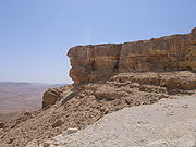
valley. The Negev has a number of interesting cultural and geological features. Among the latter are three enormous, craterlike makhtesh
Makhtesh
A makhtesh is a geological landform considered unique to the Negev desert of Israel and the Sinai Peninsula. Although commonly known as "craters" , these formations are more accurately described as erosion cirques...
im (box canyons), which are unique to the region; Makhtesh Ramon
Makhtesh Ramon
Makhtesh Ramon is a geological feature of Israel's Negev desert. Located at the peak of Mount Negev, some 85 km south of the city of Beersheba, the landform is not actually an impact crater from a meteor, but rather is the world's largest makhtesh. The crater is 40 km long, 2-10 km wide and 500...
, Makhtesh Gadol
Makhtesh Gadol
HaMakhtesh HaGadol is a makhtesh, a geological erosional landform of Israel's Negev desert.A makhtesh has steep walls of resistant rock surrounding a deep closed valley. One of five makhteshim in Israel and seven in the world, HaMakhtesh HaGadol is the second largest, being exceptional in that it...
, and Makhtesh Katan
Makhtesh Katan
HaMakhtesh HaKatan is a makhtesh, a geological erosional landform of Israel's Negev desert. One of five makhteshim in Israel, and seven in the world, it is the third largest in Israel at 5 km by 7 km. It was charted in 1942 by Jewish explorers....
.
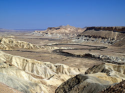
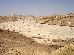
The Negev is a rocky desert. It is a melange of brown, rocky, dusty mountains interrupted by wadi
Wadi
Wadi is the Arabic term traditionally referring to a valley. In some cases, it may refer to a dry riverbed that contains water only during times of heavy rain or simply an intermittent stream.-Variant names:...
s (dry riverbeds that bloom briefly after rain) and deep craters. It can be split into five different ecological regions: northern, western, and central Negev, the high plateau and the Arabah Valley. The northern Negev, or Mediterranean
Mediterranean Sea
The Mediterranean Sea is a sea connected to the Atlantic Ocean surrounded by the Mediterranean region and almost completely enclosed by land: on the north by Anatolia and Europe, on the south by North Africa, and on the east by the Levant...
zone, receives 300 mm of rain annually and has fairly fertile soils. The western Negev receives 250 mm of rain per year, with light and partially sandy soils. Sand dunes can reach heights of up to 30 metres here. Home to the city of Beersheba
Beersheba
Beersheba is the largest city in the Negev desert of southern Israel. Often referred to as the "Capital of the Negev", it is the seventh-largest city in Israel with a population of 194,300....
, the central Negev has an annual precipitation of 200 mm and is characterized by impervious soil, known as loess
Loess
Loess is an aeolian sediment formed by the accumulation of wind-blown silt, typically in the 20–50 micrometre size range, twenty percent or less clay and the balance equal parts sand and silt that are loosely cemented by calcium carbonate...
, allowing minimum penetration of water with greater soil erosion and water runoff. The high plateau area of Ramat HaNegev stands between 370 metres and 520 metres above sea level with extreme temperatures in summer and winter. The area gets 100 mm of rain per year, with inferior and partially salty soils. The Arabah Valley along the Jordanian border stretches 180 km from Eilat in the south to the tip of the Dead Sea
Dead Sea
The Dead Sea , also called the Salt Sea, is a salt lake bordering Jordan to the east and Israel and the West Bank to the west. Its surface and shores are below sea level, the lowest elevation on the Earth's surface. The Dead Sea is deep, the deepest hypersaline lake in the world...
in the north. The Arabah Valley is very arid with barely 50 mm of rain annually. It has inferior soils in which little can grow without irrigation and special soil additives.
Climate
The whole Negev region is incredibly arid (Eilat receives on average only 31 mm of rainfall a year), receiving very little rain due to its location to the east of the SaharaSahara
The Sahara is the world's second largest desert, after Antarctica. At over , it covers most of Northern Africa, making it almost as large as Europe or the United States. The Sahara stretches from the Red Sea, including parts of the Mediterranean coasts, to the outskirts of the Atlantic Ocean...
(as opposed to the Mediterranean which lies to the west of Israel), and extreme temperatures due to its location 31 degrees north
31st parallel north
The 31st parallel north is a circle of latitude that is 31 degrees north of the Earth's equatorial plane. It crosses Africa, Asia, the Pacific Ocean, North America and the Atlantic Ocean.Part of the border between Iran and Iraq is defined by the parallel....
.
The average rainfall total from June through October is zero.
Nomads
Nomadic life in the Negev dates back at least 4,000 years and perhaps as much as 7,000 years. The first urbanized settlements were established by a combination of CanaanCanaan
Canaan is a historical region roughly corresponding to modern-day Israel, Palestine, Lebanon, and the western parts of Jordan...
ite, Amalekite, and Edomite groups circa 2000 BC. Pharaonic Egypt is credited with introducing copper mining and smelting in both the Negev and the Sinai between 1400 and 1300 BC.
Biblical
According to the Book of Genesis chapter 20, AbrahamAbraham
Abraham , whose birth name was Abram, is the eponym of the Abrahamic religions, among which are Judaism, Christianity and Islam...
lived for a while in the Negev near Kadesh
Kadesh
This article is about Kadesh in the lands of the Amurru, bordering on Damascus Syria up to Hammath; see also Kadesh or Kedesh Kadesh was an ancient city of the Levant, located on or near the headwaters or ford of the Orontes River...
after being banished from Egypt. Later the northern Negev was inhabited by the Tribe of Judah
Tribe of Judah
According to the Hebrew Bible, the Tribe of Judah was one of the Tribes of Israel.Following the completion of the conquest of Canaan by the Israelite tribes after about 1200 BCE, Joshua allocated the land among the twelve tribes....
and the southern Negev by the Tribe of Shimon. The Negev was later part of the Kingdom of Solomon
United Monarchy
According to Biblical tradition, the united Kingdom of Israel was a kingdom that existed in the Land of Israel, a period referred to by scholars as the United Monarchy. Biblical historians date the kingdom from c. 1020 BCE to c...
and then part of the Kingdom of Judah
Kingdom of Judah
The Kingdom of Judah was a Jewish state established in the Southern Levant during the Iron Age. It is often referred to as the "Southern Kingdom" to distinguish it from the northern Kingdom of Israel....
.
In the 9th century BC, development and expansion of mining in both the Negev and Edom
Edom
Edom or Idumea was a historical region of the Southern Levant located south of Judea and the Dead Sea. It is mentioned in biblical records as a 1st millennium BC Iron Age kingdom of Edom, and in classical antiquity the cognate name Idumea was used to refer to a smaller area in the same region...
(modern Jordan) coincided with the rise of the Assyrian Empire. Beersheba
Beersheba
Beersheba is the largest city in the Negev desert of southern Israel. Often referred to as the "Capital of the Negev", it is the seventh-largest city in Israel with a population of 194,300....
was the region's capital and a center for trade in the 8th century BC. Small settlements of Israelites in the areas around the capital existed between 1020 and 928 BC.
Nabateans

Avdat
Avdat , also known as Ovdat or Obodat was the most important historic city on the Incense Route after Petra between the 7th and the 1st centuries BCE. It was inhabited by Nabataeans, Romans and Byzantines. It was a seasonal camping ground for Nabataean caravans travelling along the early Petra -...
, Mamshit
Mamshit
Mamshit is the Nabataean city of Memphis. In the Nabataean period, Mamshit was an important station on Incense Road, running from the Idumean Mountains, through the Arabah and Ma'ale Akrabim, and on to Beer-Sheva or to Hebron and Jerusalem. The city covers and is the smallest but best restored...
, Shivta
Shivta
Shivta or Sobota or Subeitah or Subaytah , is an archaeological site in the Negev Desert of Israel, east of Nitzana. It is close to the Israeli Artillery Corps main training facility....
, Haluza
Haluza
Haluza , also known as Halasa, Chellous , al-Khalasa and Elusa, is a city in the Negev, Israel, that was once part of the Nabataean Incense Route. Due to this historic importance, UNESCO have granted four cities in the Negev the joint status of a World Heritage Site; Haluza is one of these, the...
(Elusa), and Nitzana
Nitzana (Nabatean city)
Nitzana is an ancient Nabataean city located in the southwest Negev desert in Israel close to the Egyptian border. It may have been a camel caravan station on the eastern branch of the ancient Incense Route, serving pilgrims and merchants travelling to Sinai or central Egypt...
. The Nabateans controlled the trade and spice route between their capital Petra
Petra
Petra is a historical and archaeological city in the Jordanian governorate of Ma'an that is famous for its rock cut architecture and water conduits system. Established sometime around the 6th century BC as the capital city of the Nabataeans, it is a symbol of Jordan as well as its most visited...
and the Gazan seaports. Nabatean currency and the remains of red and orange potsherds, identified as a trademark of their civilization, have been found along the route, remnants of which are also still visible.
Nabatean control of the Negev ended when the Roman empire
Roman Empire
The Roman Empire was the post-Republican period of the ancient Roman civilization, characterised by an autocratic form of government and large territorial holdings in Europe and around the Mediterranean....
annexed their lands in 106 AD. The population, largely made up of Arabian nomads and Nabateans, remained largely tribal and independent of Roman rule, with an animist belief system.
Byzantines and Romans
ByzantineByzantine Empire
The Byzantine Empire was the Eastern Roman Empire during the periods of Late Antiquity and the Middle Ages, centred on the capital of Constantinople. Known simply as the Roman Empire or Romania to its inhabitants and neighbours, the Empire was the direct continuation of the Ancient Roman State...
rule in the 4th century AD introduced Christianity
Christianity
Christianity is a monotheistic religion based on the life and teachings of Jesus as presented in canonical gospels and other New Testament writings...
to the population. Agricultural-based cities were established and the population grew exponentially.
The Bedouin: population and history 1000 A.D to 1948
(See section on Changing Ways of Life)Nomadic tribes ruled the Negev largely independently and with a relative lack of interference for the next thousand years. What is known of this time is largely derived from oral histories and folk tales of tribes from the Wadi Musa
Wadi Musa
Wadi Musa, , is the name of a town located in the Ma'an Governorate in southern Jordan east of Petra at latitude 30.317N and longitude 35.483E....
and Petra areas in present-day Jordan
Jordan
Jordan , officially the Hashemite Kingdom of Jordan , Al-Mamlaka al-Urduniyya al-Hashemiyya) is a kingdom on the East Bank of the River Jordan. The country borders Saudi Arabia to the east and south-east, Iraq to the north-east, Syria to the north and the West Bank and Israel to the west, sharing...
.
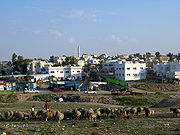
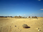
The Bedouins of the Negev historically survived chiefly on sheep and goat husbandry. Scarcity of water and of permanent pastoral land required them to move constantly. The Bedouin in years past established few permanent settlements, although some were built, leaving behind remnants of stone houses called 'baika.' In 1900 the Ottoman Empire
Ottoman Empire
The Ottoman EmpireIt was usually referred to as the "Ottoman Empire", the "Turkish Empire", the "Ottoman Caliphate" or more commonly "Turkey" by its contemporaries...
established an administrative center for southern Palestine at Beersheba including schools and a railway station. The authority of the tribal chiefs over the region was recognized by the Ottomans. A railroad connected it to the port of Rafah
Rafah
Rafah , also known as Rafiah, is a Palestinian city in the southern Gaza Strip. Located south of Gaza, Rafah's population of 71,003 is overwhelmingly made up of Palestinian refugees. Rafah camp and Tall as-Sultan form separate localities. Rafah is the district capital of the Rafah Governorate...
. By 1922 its population was 2,356, including 98 Jews and 235 Christians. In contrast in 1914 the Turkish authorities estimated the nomadic population at 55,000.
Prior to 1948 Censuses mentioned five major tribes in the Negev: the Tayaha, Tarabn, Azazma, Jabarat and Hanajra.
The tribal culture and way of life has changed dramatically recently, and today hardly any Bedouin citizens of Israel are nomadic.
The Bedouins in Israel 1948-present
The government of Israel concentrated these Bedouin tribes into the Siyag triangle of Beersheba
Beersheba
Beersheba is the largest city in the Negev desert of southern Israel. Often referred to as the "Capital of the Negev", it is the seventh-largest city in Israel with a population of 194,300....
, Arad and Dimona
Dimona
Dimona is an Israeli city in the Negev desert, to the south of Beersheba and west of the Dead Sea above the Arava valley in the Southern District of Israel. Its population at the end of 2007 was 33,600.-History:...
During 1949-1953 Israel expelled almost 17,000 Negev bedouins from the Negev, particularly from the al Auja triangle.
In 1979, Agriculture Minister Ariel Sharon
Ariel Sharon
Ariel Sharon is an Israeli statesman and retired general, who served as Israel’s 11th Prime Minister. He has been in a permanent vegetative state since suffering a stroke on 4 January 2006....
declared a 1,500 square kilometer area in the Negev a protected nature reserve, rendering a major portion of the Negev almost entirely out of bounds for Bedouin herders. In conjunction with this, he established the 'Green Patrol,' the ‘environmental paramilitary unit’ with the mission of fighting Bedouin ‘infiltration’ into national Israeli land by preventing Bedouin from creating facts on the land and grazing their animals. During Sharon’s tenure as Minister of Agriculture (1977–1981), the Green Patrol removed 900 Bedouin encampments and cut goat herds by about a 1/3.
Today the black goat is nearly extinct, and Bedouin in Israel do not have enough access to black goat hair to weave tents. Denied access to their former sources of sustenance, severed from the possibility of access to water, electricity, roads, education, and health care in the unrecognized villages, and trusting in government promises that they would receive services if they moved, in the 1970s and 1980s, tens of thousands of Bedouin resettled to 7 legal towns constructed by the government. (Falah, Ghazi. “The Spatial Pattern of Bedouin Sedentarization in Israel,” GeoJournal, 1985 Vol. 11, No. 4, pp. 361–368.) However, the towns lacked any business districts and the urban townships have long been rife with the social breakdown resulting from near-total joblessness, crime and drugs.
Today, at least 75,000 citizens live in 40 unrecognized villages
Unrecognized villages
The term Unrecognized Bedouin villages in Israel refers to Arab villages in the Negev and the Galilee which the Israeli government does not recognize as legal settlements. Approximately half of Bedouin citizens of Israel live in 39-45 such villages...
.
Contemporary Negev
Beersheba
Beersheba is the largest city in the Negev desert of southern Israel. Often referred to as the "Capital of the Negev", it is the seventh-largest city in Israel with a population of 194,300....
(pop. 185,000), in the north. At its southern end is the Gulf of Aqaba
Gulf of Aqaba
The Gulf of Aqaba is a large gulf located at the northern tip of the Red Sea. In pre twentieth-century and modern sources it is often named the Gulf of Eilat, as Eilat is its predominant Israeli city ....
=Gulf of Eilat and the resort city
City
A city is a relatively large and permanent settlement. Although there is no agreement on how a city is distinguished from a town within general English language meanings, many cities have a particular administrative, legal, or historical status based on local law.For example, in the U.S...
of Eilat. It contains several development town
Development town
Development town is a term used to refer to the new settlements that were built in Israel during the 1950s in order to provide permanent housing to a large influx of Jewish refugees from Arab countries, Holocaust survivors from Europe and new immigrants , who arrived to the newly established State...
s, including Dimona
Dimona
Dimona is an Israeli city in the Negev desert, to the south of Beersheba and west of the Dead Sea above the Arava valley in the Southern District of Israel. Its population at the end of 2007 was 33,600.-History:...
, Arad, Mitzpe Ramon
Mitzpe Ramon
Mitzpe Ramon is a town in the Negev desert of southern Israel. It is situated on the northern ridge at an elevation of 860 meters overlooking a sizable erosion cirque known as the Ramon Crater.-History:...
, as well as a number of small Bedouin
Bedouin
The Bedouin are a part of a predominantly desert-dwelling Arab ethnic group traditionally divided into tribes or clans, known in Arabic as ..-Etymology:...
cities, including Rahat
Rahat
Rahat is a predominantly Bedouin city in the South District of Israel. According to the Israel Central Bureau of Statistics , at the end of 2009 the city had a total population of 51,700...
and Tel as-Sabi. There are also several kibbutz
Kibbutz
A kibbutz is a collective community in Israel that was traditionally based on agriculture. Today, farming has been partly supplanted by other economic branches, including industrial plants and high-tech enterprises. Kibbutzim began as utopian communities, a combination of socialism and Zionism...
im, including Revivim
Revivim
Revivim showers) is a kibbutz in the Negev desert in southern Israel. Located around half an hour south of Beersheba, it falls under the jurisdiction of Ramat HaNegev Regional Council...
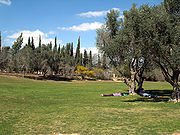
and Sde Boker
Sde Boker
Sde Boker is a kibbutz in the Negev desert of southern Israel. Best known as the retirement home of Israel's first Prime Minister, David Ben-Gurion, it falls under the jurisdiction of Ramat HaNegev Regional Council.-History:...
; the latter became the home of Israel's first Prime Minister
Prime Minister of Israel
The Prime Minister of Israel is the head of the Israeli government and the most powerful political figure in Israel . The prime minister is the country's chief executive. The official residence of the prime minister, Beit Rosh Hamemshala is in Jerusalem...
, David Ben-Gurion
David Ben-Gurion
' was the first Prime Minister of Israel.Ben-Gurion's passion for Zionism, which began early in life, led him to become a major Zionist leader and Executive Head of the World Zionist Organization in 1946...
, after his retirement from politics.
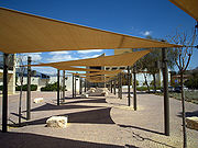
The desert is home to the Ben-Gurion University of the Negev
Ben-Gurion University of the Negev
Ben-Gurion University of the Negev is a university in Beersheba, Israel, established in 1969. Ben-Gurion University of the Negev has a current enrollment of 17,400 students, and is one of Israel's fastest growing universities....
, whose faculties include the Jacob Blaustein Institutes for Desert Research and the Albert Katz International School for Desert Studies
Albert Katz International School for Desert Studies
The Albert Katz International School for Desert Studies is a faculty of the Jacob Blaustein Institutes for Desert Research and part of the Ben-Gurion University of the Negev...
, both located on the Midreshet Ben-Gurion
Midreshet Ben-Gurion
Midreshet Ben-Gurion , also known as Midreshet Sde Boker, is a communal settlement in southern Israel. Located near Sde Boker in the Negev desert, it falls under the jurisdiction of Ramat HaNegev Regional Council. In 2010 it had a population of 1,200....
campus adjacent to Sde Boker
Sde Boker
Sde Boker is a kibbutz in the Negev desert of southern Israel. Best known as the retirement home of Israel's first Prime Minister, David Ben-Gurion, it falls under the jurisdiction of Ramat HaNegev Regional Council.-History:...
.
Today, the Negev has an enormous Israeli military presence and is home to many of the Israel Defense Forces
Israel Defense Forces
The Israel Defense Forces , commonly known in Israel by the Hebrew acronym Tzahal , are the military forces of the State of Israel. They consist of the ground forces, air force and navy. It is the sole military wing of the Israeli security forces, and has no civilian jurisdiction within Israel...
major bases. As of 2010 the Negev was home to some 630,000 people (or 8.2% of Israel
Israel
The State of Israel is a parliamentary republic located in the Middle East, along the eastern shore of the Mediterranean Sea...
's population), even though it comprises over 55% of the country's landmass. 470,000 Negev residents or 75% of the population of the Negev are Jews
Jews
The Jews , also known as the Jewish people, are a nation and ethnoreligious group originating in the Israelites or Hebrews of the Ancient Near East. The Jewish ethnicity, nationality, and religion are strongly interrelated, as Judaism is the traditional faith of the Jewish nation...
while 160,000 or 25% of them are Negev Bedouin. Of the Bedouin population, half live in unrecognized villages
Unrecognized villages
The term Unrecognized Bedouin villages in Israel refers to Arab villages in the Negev and the Galilee which the Israeli government does not recognize as legal settlements. Approximately half of Bedouin citizens of Israel live in 39-45 such villages...
, and half live in towns built for them by the government between the 1960 and 1980s; the largest of these is Rahat
Rahat
Rahat is a predominantly Bedouin city in the South District of Israel. According to the Israel Central Bureau of Statistics , at the end of 2009 the city had a total population of 51,700...
.
Contemporary environmental issues
85% of the Negev is used by the Israel Defense Forces for training purposes. In the remaining portion of the Negev available for civilian purposes, a large number of citizens live together in close proximity to a range of types of hazardous infrastructure, which includes a nuclear reactor, 22 agro and petrochemical factories, an oil terminal, closed military zones, quarries, a toxic waste incinerator Ramat HovavRamat Hovav
Ramat Hovav is an industrial zone in southern Israel and the site of Israel's main hazardous waste disposal facility. Ramat Hovav Industrial Zone is the locus of 19 chemical factories, including Makhteshim Agan, a pesticide plant; Teva Pharmaceutical Industries, a pharmaceuticals plant; Israel...
, cell towers, a power plant, several airports, a prison, and 2 rivers of open sewage.
The Ramat Hovav
Ramat Hovav
Ramat Hovav is an industrial zone in southern Israel and the site of Israel's main hazardous waste disposal facility. Ramat Hovav Industrial Zone is the locus of 19 chemical factories, including Makhteshim Agan, a pesticide plant; Teva Pharmaceutical Industries, a pharmaceuticals plant; Israel...
toxic waste facility was planted in the area of Beer Sheva and Wadi el-Na'am
Wadi al-Na'am
Wadi al-Na'am is an unrecognized village in the Negev Desert in Southern Israel. The nearest official settlement is Beersheba. The village is home to about 5,000 Bedouin that live mainly in tents and tin shacks less than 500 meters away from a toxic waste dump, largely surrounded by the Ramat Hovav...
in 1979 because the area was perceived as invulnerable to leakage. However, within a decade, cracks were found in the rock beneath Ramat Hovav. From its inception, the facility developed a history of accidents and closures; in the past, regional councils regularly discovered that the evaporation pools of Ramat Hovav's Machteshim
Ramat Hovav
Ramat Hovav is an industrial zone in southern Israel and the site of Israel's main hazardous waste disposal facility. Ramat Hovav Industrial Zone is the locus of 19 chemical factories, including Makhteshim Agan, a pesticide plant; Teva Pharmaceutical Industries, a pharmaceuticals plant; Israel...
chemical factory had overflowed or that waste was leaking from drainage pipes into their reservoir. Nearly ten years after its establishment, outcrops of the chalk under Ramat Hovav showed fractures potentially leading to serious soil and groundwater contamination in the future.
In 2004, the Israeli Ministry of Health released Ben Gurion University research findings describing the health problems in a 20 km vicinity of Ramat Hovav. The study, funded in large part by Ramat Hovav, found higher rates of cancer and mortality for the 350,000 people in the area, amounting to a public health crisis. Prematurely released to the media by an unknown source, the preliminary study was publicly discredited; however, its final conclusions – that Bedouin and Jewish residents near Ramat Hovav are significantly more susceptible than the rest of the population to miscarriages, severe birth defects, and respiratory diseases – passed a peer review several months later.
Jewish National Fund
The Jewish National Fund was founded in 1901 to buy and develop land in Ottoman Palestine for Jewish settlement. The JNF is a quasi-governmental, non-profit organisation...
introduced its Blueprint Negev
Blueprint Negev
Blueprint Negev is a Jewish National Fund project to develop the Negev region of Israel.The project aims to increase the Negev's population by 250,000 new residents, improving transportation infrastructure, adding businesses and employment opportunities, preserving water resources and protecting...
in 2005, a $600 million project aimed at attracting 500,000 new settlers to the Negev and constructing new settlements to accommodate them. The project says it will increase the Negev's population by 250,000 new residents by 2013, improving transportation infrastructure, adding businesses and employment opportunities, preserving water resources and protecting the environment. The Blueprint Negev's planned artificial desert river, swimming pools and golf courses raise concerns among environmentalists given Israel's water shortage. The main thrust of critics' argument is that the appropriate response to overpopulation is not to recruit hundreds of thousands of additional settlers, and the answer to over-development in the north is not to build up the last open spaces in the second most-densely crowded country in the developed world; rather, what is required is an inclusive plan for the green vitalization of existing population centers in the Negev, investment in long-awaited service-provision in Bedouin villages, clean-up of its many toxic industries (such as Ramat Hovav
Ramat Hovav
Ramat Hovav is an industrial zone in southern Israel and the site of Israel's main hazardous waste disposal facility. Ramat Hovav Industrial Zone is the locus of 19 chemical factories, including Makhteshim Agan, a pesticide plant; Teva Pharmaceutical Industries, a pharmaceuticals plant; Israel...
), and the development of a viable economic plan focusing on creating job options for the unemployed rather than promoting an influx of new immigrants and creating jobs for them.
Solar power

Arable land
In geography and agriculture, arable land is land that can be used for growing crops. It includes all land under temporary crops , temporary meadows for mowing or pasture, land under market and kitchen gardens and land temporarily fallow...
, which is why it has become the center of the Israeli solar industry. David Faiman
David Faiman
David Faiman is an Israeli engineer and physicist. He is a world expert on solar power. He is the director of the Ben-Gurion National Solar Energy Center and Chairman of the Department of Solar Energy & Environmental Physics at Ben-Gurion University's Jacob Blaustein Institutes for Desert...
, an expert on solar energy, feels the energy needs of Israel's future could be met by building solar energy plants in the Negev. As director of Ben-Gurion National Solar Energy Center
Ben-Gurion National Solar Energy Center
The Ben-Gurion National Solar Energy Center at Midreshet Ben-Gurion is the national alternative energy research institute of Israel. It was established in 1987 by the Ministry of National Infrastructures to study promising alternative and clean energy technologies, particularly those involving...
, he operates one of the largest solar dishes in the world. Technically, however, the Aravah is a separate desert with its own unique climate and ecology.
A 250 MW solar park in Ashalim
Ashalim
Ashalim is a small communal settlement in southern Israel. Located in the Negev desert about 35 km south of Be'er Sheva and on the eastern side of Nahal Besor, the largest stream in the Negev, it falls under the jurisdiction of the Ramat Negev Regional Council...
, an area in the northern Negev, was in the planning stages for over five years, but it is not expected to produce power before 2013. In 2008 construction began on three solar power plants near the city; two thermal
Solar thermal energy
Solar thermal energy is a technology for harnessing solar energy for thermal energy . Solar thermal collectors are classified by the United States Energy Information Administration as low-, medium-, or high-temperature collectors. Low-temperature collectors are flat plates generally used to heat...
and one photovoltaic.
The Rotem Industrial Complex outside of Dimona, Israel has dozens of solar mirrors that focus the sun's rays on a tower that in turn heats a water boiler to create steam, turning a turbine to create electricity. Luz II, Ltd. plans to use the solar array to test new technology for the three new solar plants to be built in California for Pacific Gas and Electric Company
Pacific Gas and Electric Company
The Pacific Gas and Electric Company , commonly known as PG&E, is the utility that provides natural gas and electricity to most of the northern two-thirds of California, from Bakersfield almost to the Oregon border...
.
See also
- BeershebaBeershebaBeersheba is the largest city in the Negev desert of southern Israel. Often referred to as the "Capital of the Negev", it is the seventh-largest city in Israel with a population of 194,300....
- Blueprint NegevBlueprint NegevBlueprint Negev is a Jewish National Fund project to develop the Negev region of Israel.The project aims to increase the Negev's population by 250,000 new residents, improving transportation infrastructure, adding businesses and employment opportunities, preserving water resources and protecting...
- Eilat
- Negev Bedouins
- Sinai PeninsulaSinai PeninsulaThe Sinai Peninsula or Sinai is a triangular peninsula in Egypt about in area. It is situated between the Mediterranean Sea to the north, and the Red Sea to the south, and is the only part of Egyptian territory located in Asia as opposed to Africa, effectively serving as a land bridge between two...
- Southern District (Israel)
External links
- Sde Boker archive of articles on the Negev
- Negev Wikitravel
- Israel's Negev Information Site
- About the Bedouin in unrecognized villages
- About changes in Bedouin life
- About Negev environmental issues
- Negev Desert Socio-Environmental Timeline
This article is about the southern region of Israel. For the light machine gun see IMI Negev
IMI Negev
The Negev is an Israeli 5.56 mm light machine gun, developed by Israel Military Industries Ltd. of Ramat HaSharon , as a replacement for the 5.56 mm Galil ARM light machine gun, whose barrel would overheat easily during sustained fire...
.