

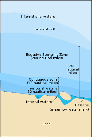
Territorial waters
Encyclopedia
United Nations Convention on the Law of the Sea
The United Nations Convention on the Law of the Sea , also called the Law of the Sea Convention or the Law of the Sea treaty, is the international agreement that resulted from the third United Nations Conference on the Law of the Sea , which took place from 1973 through 1982...
, is a belt of coastal waters extending at most 12 nautical miles (22.2 km) from the baseline
Baseline (sea)
A baseline is the line from which the seaward limits of a State's territorial sea and certain other maritime zones of jurisdiction are measured. Normally, a sea baseline follows the low-water line of a coastal State...
(usually the mean low-water mark) of a coast
Coast
A coastline or seashore is the area where land meets the sea or ocean. A precise line that can be called a coastline cannot be determined due to the dynamic nature of tides. The term "coastal zone" can be used instead, which is a spatial zone where interaction of the sea and land processes occurs...
al state. The territorial sea is regarded as the sovereign territory of the state, although foreign ships (both military and civilian) are allowed innocent passage
Innocent passage
Innocent passage is a concept in admiralty law which allows for a vessel to pass through the territorial waters of another state subject to certain restrictions. The UN Convention on the Law of the Sea defines innocent passage as:...
through it; this sovereignty also extends to the airspace over and seabed below.
The term "territorial waters" is also sometimes used informally to describe any area of water over which a state has jurisdiction
Jurisdiction
Jurisdiction is the practical authority granted to a formally constituted legal body or to a political leader to deal with and make pronouncements on legal matters and, by implication, to administer justice within a defined area of responsibility...
, including internal waters
Internal waters
A nation's internal waters covers all water and waterways on the landward side of the baseline from which a nation's territorial waters is defined. It includes waterways such as rivers and canals, and sometimes the water within small bays. According to the United Nations Convention on the Law of...
, the contiguous zone, the exclusive economic zone
Exclusive Economic Zone
Under the law of the sea, an exclusive economic zone is a seazone over which a state has special rights over the exploration and use of marine resources, including production of energy from water and wind. It stretches from the seaward edge of the state's territorial sea out to 200 nautical...
and potentially the continental shelf
Continental shelf
The continental shelf is the extended perimeter of each continent and associated coastal plain. Much of the shelf was exposed during glacial periods, but is now submerged under relatively shallow seas and gulfs, and was similarly submerged during other interglacial periods. The continental margin,...
.
Baseline
Normally, the baseline from which the territorial sea is measured is the low-water line along the coast as marked on large-scale charts officially recognized by the coastal state. This is either the low-water mark closest to the shore, or alternatively it may be an unlimited distance from permanently exposed land, provided that some portion of elevations exposed at low tide but covered at high tide (like mud flats) is within 12 nautical miles (22.2 km) of permanently exposed land. Straight baselines can alternatively be defined connecting fringing islands along a coast, across the mouths of rivers, or with certain restrictions across the mouths of bays. In this case, a bay is defined as "a well-marked indentation whose penetration is in such proportion to the width of its mouth as to contain land-locked waters and constitute more than a mere curvature of the coast. An indentation shall not, however, be regarded as a bay unless its area is as large as, or larger than, that of the semi-circle whose diameter is a line drawn across the mouth of that indentation". The baseline across the bay must also be no more than 24 nautical miles (44.4 km) in length.Internal waters
Internal waters
A nation's internal waters covers all water and waterways on the landward side of the baseline from which a nation's territorial waters is defined. It includes waterways such as rivers and canals, and sometimes the water within small bays. According to the United Nations Convention on the Law of...
, over which the state has complete jurisdiction: not even innocent passage is allowed. Lakes and rivers are considered internal waters, as are all "archipelagic waters" within the outermost islands of an archipelagic state such as Indonesia
Indonesia
Indonesia , officially the Republic of Indonesia , is a country in Southeast Asia and Oceania. Indonesia is an archipelago comprising approximately 13,000 islands. It has 33 provinces with over 238 million people, and is the world's fourth most populous country. Indonesia is a republic, with an...
, Japan
Japan
Japan is an island nation in East Asia. Located in the Pacific Ocean, it lies to the east of the Sea of Japan, China, North Korea, South Korea and Russia, stretching from the Sea of Okhotsk in the north to the East China Sea and Taiwan in the south...
or the Philippines
Philippines
The Philippines , officially known as the Republic of the Philippines , is a country in Southeast Asia in the western Pacific Ocean. To its north across the Luzon Strait lies Taiwan. West across the South China Sea sits Vietnam...
.
Territorial sea
A state's territorial sea extends up to 12 nautical miles from its baseline. If this would overlap with another state's territorial sea, the border is taken as the median point between the states' baselines, unless the states in question agree otherwise. A state can also choose to claim a smaller territorial sea.Conflicts still occur whenever a coastal nation claims an entire gulf as its territorial waters while other nations only recognize the more restrictive definitions of the UN convention. Two recent conflicts occurred in the Gulf of Sidra
Gulf of Sidra
Gulf of Sidra is a body of water in the Mediterranean Sea on the northern coast of Libya; it is also known as Gulf of Sirte or the Great Sirte or Greater Syrtis .- Geography :The Gulf of Sidra has been a major centre for tuna fishing in the Mediterranean for centuries...
where Libya has claimed the entire gulf as its territorial waters and the U.S. has twice enforced freedom of navigation
Freedom of Navigation
Freedom of Navigation is a principle of customary International Law that, apart from the exceptions provided for in international law, ships flying the flag of any state shall not suffer interference from other states. This right is now also codified as article 87a of the 1982 United Nations...
rights, in the 1981
Gulf of Sidra incident (1981)
In the first Gulf of Sidra incident, 19 August 1981, two Libyan Su-22 Fitter attack aircraft were shot down by two American F-14 Tomcats off of the Libyan coast.-Background:...
and 1989
Gulf of Sidra incident (1989)
The second Gulf of Sidra incident occurred on 4 January 1989 when two US F-14 Tomcats shot down two Libyan MiG-23 Flogger-Es that gave all appearances of attempting to engage them, as had happened seven years prior in the first Gulf of Sidra incident ....
Gulf of Sidra incidents.
Contiguous zone
The contiguous zone is a band of water extending from the outer edge of the territorial sea to up to 24 nautical miles (44.4 km) from the baseline, within which a state can exert limited control for the purpose of preventing or punishing "infringement of its customs, fiscal, immigration or sanitary laws and regulations within its territory or territorial sea". This will typically be 12 nautical miles (22.2 km) wide, but could be more (if a state has chosen to claim a territorial sea of less than 12 nautical miles), or less, if it would otherwise overlap another state's contiguous zone. However, unlike the territorial sea there is no standard rule for resolving such conflicts, and the states in question must negotiate their own compromise. The United StatesUnited States
The United States of America is a federal constitutional republic comprising fifty states and a federal district...
invoked a contiguous zone out to 24 nm on 24 September 1999.
Exclusive economic zone
An exclusive economic zoneExclusive Economic Zone
Under the law of the sea, an exclusive economic zone is a seazone over which a state has special rights over the exploration and use of marine resources, including production of energy from water and wind. It stretches from the seaward edge of the state's territorial sea out to 200 nautical...
extends from the outer limit of the territorial sea to a maximum of 200 nautical miles (370.4 km) from the territorial sea baseline, thus it includes the contiguous zone. A coastal nation has control of all economic resources within its exclusive economic zone, including fishing, mining, oil exploration, and any pollution of those resources. However, it cannot prohibit passage or loitering above, on, or under the surface of the sea that is in compliance with the laws and regulations adopted by the coastal State in accordance with the provisions of the UN Convention, within that portion of its exclusive economic zone beyond its territorial sea. Before 1982, coastal nations arbitrarily extended their territorial waters in an effort to control activities which are now regulated by the exclusive economic zone, such as offshore oil exploration
Oil exploration
Hydrocarbon exploration is the search by petroleum geologists and geophysicists for hydrocarbon deposits beneath the Earth's surface, such as oil and natural gas...
or fishing rights (see Cod Wars). Indeed, the exclusive economic zone is still popularly, though erroneously, called a coastal nation's territorial waters.
Definition
Article 76 gives the legal definition of continental shelf of coastal countries. For the physical geography definition, see the continental shelfContinental shelf
The continental shelf is the extended perimeter of each continent and associated coastal plain. Much of the shelf was exposed during glacial periods, but is now submerged under relatively shallow seas and gulfs, and was similarly submerged during other interglacial periods. The continental margin,...
page.
The continental shelf of a coastal nation extends out to the outer edge of the continental margin
Continental margin
The continental margin is the zone of the ocean floor that separates the thin oceanic crust from thick continental crust. Continental margins constitute about 28% of the oceanic area....
but at least 200 nautical miles (370.4 km) from the baselines of the territorial sea if the continental margin does not stretch that far. The outer limit of a country's continental shelf shall not stretch beyond 350 nautical miles (648.2 km) of the baseline, or beyond 100 nautical miles (185.2 km) from the 2500 metres (8,202.1 ft) isobath, which is a line connecting the depths of the seabed at 2,500 meters.
The outer edge of the continental margin for the purposes of this article is defined as:
- a series of lines joining points not more than 60 nautical miles (111.1 km) apart where the thickness of sedimentary rocks is at least 1% of the height of the continental shelf above the foot of the continental slope; or
- a series of lines joining points not more than 60 nautical miles apart that is not more than 60 nautical miles from the foot of the continental margin.
The foot of the continental slope is determined as the point of maximum change in the gradient at its base.
The portion of the continental shelf beyond the 200 nautical mile limit is also known as the extended continental shelf. Countries wishing to delimit their outer continental shelf beyond 200 nautical miles have to submit information on their claim to the Commission on the Limits of the Continental Shelf. The Commission must make recommendations on matters related to the establishment of the outer limits of their continental shelf. The limits established based on these recommendations shall be final and binding.
Countries were supposed to lodge their submissions to extend their continental shelf beyond 200 nautical miles within ten years of UNCLOS coming into force in the country, or by 13 May 2009 for countries where the convention had come into force before 13 May 1999. As of 1 June 2009, 51 submissions have been lodged with the Commission, of which eight have been deliberated by the Commission and have had recommendations issued. The eight are (in the order of date of submission): Russian Federation; Brazil; Australia; Ireland; New Zealand; the joint submission by France, Ireland, Spain and the United Kingdom; Norway and Mexico.
For full list, see below
Rights over the continental shelf
Articles 77 to 81 define the rights of a country over its continental shelf.A coastal nation has control of all resources on or under its continental shelf, living or not, but no control over any living organisms above the shelf that are beyond its exclusive economic zone. This gives it the right to conduct petroleum drilling works and lay submarine cables or pipelines in its continental shelf.
Background
From the eighteenth century until the mid twentieth century, the territorial waters of the British EmpireBritish Empire
The British Empire comprised the dominions, colonies, protectorates, mandates and other territories ruled or administered by the United Kingdom. It originated with the overseas colonies and trading posts established by England in the late 16th and early 17th centuries. At its height, it was the...
, the United States
United States
The United States of America is a federal constitutional republic comprising fifty states and a federal district...
, France
France
The French Republic , The French Republic , The French Republic , (commonly known as France , is a unitary semi-presidential republic in Western Europe with several overseas territories and islands located on other continents and in the Indian, Pacific, and Atlantic oceans. Metropolitan France...
and many other nations were three nautical miles (5.6 km) wide
Three-mile limit
The three-mile limit refers to a traditional and now largely obsolete conception of the international law of the seas which defined a country's territorial waters, for the purposes of trade regulation and exclusivity, as extending as far as the reach of cannons fired from land.In Mare clausum John...
. Originally, this was the length of a cannon
Cannon
A cannon is any piece of artillery that uses gunpowder or other usually explosive-based propellents to launch a projectile. Cannon vary in caliber, range, mobility, rate of fire, angle of fire, and firepower; different forms of cannon combine and balance these attributes in varying degrees,...
shot, hence the portion of an ocean that a sovereign state could defend from shore. However, Iceland
Iceland
Iceland , described as the Republic of Iceland, is a Nordic and European island country in the North Atlantic Ocean, on the Mid-Atlantic Ridge. Iceland also refers to the main island of the country, which contains almost all the population and almost all the land area. The country has a population...
claimed two nautical miles (3.7 km), Norway
Norway
Norway , officially the Kingdom of Norway, is a Nordic unitary constitutional monarchy whose territory comprises the western portion of the Scandinavian Peninsula, Jan Mayen, and the Arctic archipelago of Svalbard and Bouvet Island. Norway has a total area of and a population of about 4.9 million...
and Sweden
Sweden
Sweden , officially the Kingdom of Sweden , is a Nordic country on the Scandinavian Peninsula in Northern Europe. Sweden borders with Norway and Finland and is connected to Denmark by a bridge-tunnel across the Öresund....
claimed four nautical miles (7.4 km), and Spain
Spain
Spain , officially the Kingdom of Spain languages]] under the European Charter for Regional or Minority Languages. In each of these, Spain's official name is as follows:;;;;;;), is a country and member state of the European Union located in southwestern Europe on the Iberian Peninsula...
claimed 6 nautical miles (11.1 km) during this period. During incidents such as nuclear weapons testing and fisheries disputes some nations arbitrarily extended their maritime claims to as much as fifty or even two hundred nautical miles. Since the late 20th century the "12 mile limit" has become almost universally accepted. The United Kingdom
United Kingdom
The United Kingdom of Great Britain and Northern IrelandIn the United Kingdom and Dependencies, other languages have been officially recognised as legitimate autochthonous languages under the European Charter for Regional or Minority Languages...
extended its territorial waters from three to twelve nautical miles (22 km) in 1987.
Claims by legislation to the adjacent continental shelf and fishing was first made by the United States government immediately following the Second World War. On September 28, 1945, US President Harry S. Truman
Harry S. Truman
Harry S. Truman was the 33rd President of the United States . As President Franklin D. Roosevelt's third vice president and the 34th Vice President of the United States , he succeeded to the presidency on April 12, 1945, when President Roosevelt died less than three months after beginning his...
issued two proclamations that established government control of natural resources in areas adjacent to the coastline. One of these proclamation was titled "Policy of the United States With Respect to the Natural Resources of the Subsoil and
Sea Bed of the Continental Shelf", and stipulated in its operative clause:
the Government of the United States regards the natural resources of the subsoil and sea bed of the continental shelf beneath the high seas but contiguous to the coasts of the United States as appertaining to the United States, subject to its jurisdiction and control.
The second proclamation was titled "Policy of the United States With Respect to Coastal Fisheries in Certain Areas of the High Seas", and stated in its operative clause:
the Government of the United States regards it as proper to establish conservation zones in those areas of the high seas contiguous to the coasts of the United States wherein fishing activities have been or in the future may be developed and maintained on a substantial scale.
Miscellaneous
Pirate radioPirate radio
Pirate radio is illegal or unregulated radio transmission. The term is most commonly used to describe illegal broadcasting for entertainment or political purposes, but is also sometimes used for illegal two-way radio operation...
broadcasting from artificial marine fixtures or anchored ships can be controlled by the affected coastal nation or other nations wherever that broadcast may originate, whether in the territorial sea, exclusive economic zone, the continental shelf or even on the high seas.
Thus a coastal nation has total control over its internal waters, slightly less control over territorial waters, and ostensibly even less control over waters within the contiguous zones. However, it has total control of economic resources within its exclusive economic zone as well as those on or under its continental shelf.
Throughout this article, distances measured in nautical miles are exact legal definitions, while those in kilometres are approximate conversions that are not stated in any law or treaty.
Federal nations, such as the United States, divide control over certain waters between the federal government and the individual states. (See tidelands
Tidelands
Tidelands are the territory between the high and low water tide line of sea coasts, and lands lying under the sea beyond the low-water limit of the tide, considered within the territorial waters of a nation. The United States Constitution does not specify whether ownership of these lands rests with...
.)
Territorial sea claims
Maritime controversies involve two dimensions: (a) territorial sovereignty, which are a legacy of history; and (b) relevant jurisdictional rights and interests in maritime boundaries
Maritime boundary
Maritime boundary is a conceptual means of division of the water surface of the planet into maritime areas that are defined through surrounding physical geography or by human geography. As such it usually includes areas of exclusive national rights over the mineral and biological resources,...
, which are mainly due to differing interpretations of the law of the sea.
- None: Bosnia and Herzegovina, which is not a landlocked country.: Jordan, Palau, Singapore: Dominican Republic, Greece, Turkey (but only in the Aegean Sea): Albania, Algeria, Angola, Antigua and Barbuda, Argentina, Australia, Bahamas, Bahrain, Bangladesh, Barbados, Belgium, Belize, Brazil, Brunei, Bouvet Island Bulgaria, Cambodia, Cameroon, Canada, Cape Verde, Chile, People's Republic of China, Republic of China, Colombia, Comoros, Cook Islands, Costa Rica, Côte d'Ivoire, Croatia, Cuba, Cyprus, Democratic People's Republic of Korea, Democratic Republic of the Congo, Denmark, Djibouti, Dominica, Egypt, Equatorial Guinea, Eritrea, Estonia, Faroe Islands, Fiji, Finland, France, Gabon, Gambia, Georgia, Germany, Ghana, Grenada, Guatemala, Guinea, Guinea-Bissau, Guyana, Haiti, Honduras, India, Indonesia, Iran, Iraq, Ireland, Israel, Italy, Jamaica, Japan, Kenya, Kiribati, Kuwait, Latvia, Lebanon, Libya, Lithuania, Madagascar, Malaysia, Maldives, Malta, Marshall Islands, Mauritania, Mauritius, Mexico, Micronesia, Monaco, Montenegro, Morocco, Mozambique, Myanmar, Namibia, Nauru, Netherlands, New Zealand, Nicaragua, Nigeria, Niue, Norway, Oman, Pakistan, Panama, Papua New Guinea, Poland, Portugal, Qatar, Republic of Korea, Romania, Russia, Saint Kitts and Nevis, Saint Lucia, Saint Vincent and the Grenadines, Samoa, São Tomé and Príncipe, Saudi Arabia, Senegal, Seychelles, Sierra Leone, Solomon Islands, South Africa, Spain, Sri Lanka, Sudan, Suriname, Sweden, Syria, Thailand, Timor-Leste, Tonga, Trinidad and Tobago, Tunisia, Turkey (in the Black sea and Mediterranean), Tuvalu, Ukraine, United Arab Emirates, United Kingdom, United Republic of Tanzania, United States of America, Uruguay, Vanuatu, Venezuela, Vietnam, Yemen
- 12 nautical miles/DLM: Slovenia: Togo: Benin, Republic of the Congo, Ecuador, El Salvador, Liberia, Peru, Somalia, Iceland
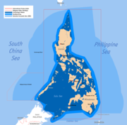
- Defined by coordinates: the Philippines claims a rectangle, defined by coordinates; the total claim extends beyond 12 nautical miles.
Special cases
- Australia: A treaty with Papua New Guinea defines the territorial sea boundaries between the islands of Aubusi, Boigu and Moimi and Papua New Guinea on the one hand and the islands of Dauan, Kaumag and Saibai and Papua New Guinea on the other hand, as well as a section of the border of the territorial sea of Saibai. The territorial seas of the islands known as Anchor Cay, Aubusi Island, Black Rocks, Boigu Island, Bramble Cay, Dauan Island, Deliverance Island, East Cay, Kaumag Island, Kerr Islet, Moimi Island, Pearce Cay, Saibai Island, Urnagain Island and Turu Cay do not extend beyond 3 nautical miles from the baselines.
- Belize: 3 nautical miles limit applies from the mouth of Sarstoon River to Ranguana Caye.
- Cameroon: See article 45 of Law 96-06 of 18 January 1996 on the revision of the Constitution of 2 June 1972.
- Denmark: Act No. 200 of 7 April 1999 on the delimitationBoundary delimitationBoundary delimitation, or simply delimitation, is the term used to describe the drawing of boundaries, but is most often used to describe the drawing of electoral boundaries, specifically those of precincts, states, counties or other municipalities...
of the territorial sea does not apply to the Faroe Islands (the act applies to the Faroe Islands from 1 June 2002) and Greenland but may become effective by Royal Decree for those parts of the Kingdom of Denmark with the amendments dictated by the special conditions prevailing in the Faroe Islands and Greenland. As far as Greenland is concerned, the outer limit of the external territorial waters may be measured at a distance shorter than 12 nautical miles (22.2 km) from the baselines. - Ecuador: The 200 nautical miles (370.4 km) limit is in effect only between the continental territorial sea of Ecuador and its insular territorial sea around the Galápagos Islands.
- Estonia: In some parts of the Gulf of Finland, defined by coordinates.
- Finland: Extends, with certain exceptions, to 12 nautical miles, unless defined by geographical coordinates. In the Gulf of Finland, the outer limit of the territorial sea shall at no place be closer to the midline than 3 nautical miles, according to the Act amending the Act on the Limits of the Territorial Waters of Finland (981/95).
- Greece: 10 nautical miles (18.5 km) limit applies for the purpose of regulating civil aviation (See also Aegean disputeAegean disputeThe Aegean dispute is a set of interrelated controversial issues between Greece and Turkey over sovereignty and related rights in the area of the Aegean Sea. This set of conflicts has had a large effect on Greek-Turkish relations since the 1970s. It has twice led to crises coming close to the...
) - India: 12 nautical miles limit includes Andaman, Nicobar and Lakshadweep.
- Japan: 3 nautical miles limit applies to the Soya Strait, the Tsugaru Strait, the eastern and western channels of the Korea Strait and the Osumi Straits only.
- New Zealand: 12 nautical miles (22.2 km) limit includes Tokelau.
- Papua New Guinea: 3 nautical miles (5.6 km) in certain areas.
- Peru: The 200 nautical miles (370.4 km) territorial sea is called 'Maritime Dominion' in article 54 of the 1993 Constitution: " ...In its maritime dominion, Peru exercises sovereignty and jurisdiction, without prejudice to the freedoms of international communication, in accordance with the law and the treaties ratified by the State..."
- Turkey: 6 nautical miles (11.1 km) in the Aegean Sea, 12 nautical miles (22.2 km) in the Black Sea.
- United Kingdom: The limit remains at 3 nautical miles (5.6 km) in some of its overseas territories: AnguillaAnguillaAnguilla is a British overseas territory and overseas territory of the European Union in the Caribbean. It is one of the most northerly of the Leeward Islands in the Lesser Antilles, lying east of Puerto Rico and the Virgin Islands and directly north of Saint Martin...
, GuernseyGuernseyGuernsey, officially the Bailiwick of Guernsey is a British Crown dependency in the English Channel off the coast of Normandy.The Bailiwick, as a governing entity, embraces not only all 10 parishes on the Island of Guernsey, but also the islands of Herm, Jethou, Burhou, and Lihou and their islet...
, British Indian Ocean TerritoryBritish Indian Ocean TerritoryThe British Indian Ocean Territory or Chagos Islands is an overseas territory of the United Kingdom situated in the Indian Ocean, halfway between Africa and Indonesia...
, British Virgin IslandsBritish Virgin IslandsThe Virgin Islands, often called the British Virgin Islands , is a British overseas territory and overseas territory of the European Union, located in the Caribbean to the east of Puerto Rico. The islands make up part of the Virgin Islands archipelago, the remaining islands constituting the U.S...
, GibraltarGibraltarGibraltar is a British overseas territory located on the southern end of the Iberian Peninsula at the entrance of the Mediterranean. A peninsula with an area of , it has a northern border with Andalusia, Spain. The Rock of Gibraltar is the major landmark of the region...
, Monserrat and Pitcairn; the limit is now at 12 nautical miles (22.2 km) in the United Kingdom and its territories of JerseyJerseyJersey, officially the Bailiwick of Jersey is a British Crown Dependency off the coast of Normandy, France. As well as the island of Jersey itself, the bailiwick includes two groups of small islands that are no longer permanently inhabited, the Minquiers and Écréhous, and the Pierres de Lecq and...
, BermudaBermudaBermuda is a British overseas territory in the North Atlantic Ocean. Located off the east coast of the United States, its nearest landmass is Cape Hatteras, North Carolina, about to the west-northwest. It is about south of Halifax, Nova Scotia, Canada, and northeast of Miami, Florida...
, Cayman IslandsCayman IslandsThe Cayman Islands is a British Overseas Territory and overseas territory of the European Union located in the western Caribbean Sea. The territory comprises the three islands of Grand Cayman, Cayman Brac, and Little Cayman, located south of Cuba and northwest of Jamaica...
, Falkland IslandsFalkland IslandsThe Falkland Islands are an archipelago in the South Atlantic Ocean, located about from the coast of mainland South America. The archipelago consists of East Falkland, West Falkland and 776 lesser islands. The capital, Stanley, is on East Falkland...
, Isle of ManIsle of ManThe Isle of Man , otherwise known simply as Mann , is a self-governing British Crown Dependency, located in the Irish Sea between the islands of Great Britain and Ireland, within the British Isles. The head of state is Queen Elizabeth II, who holds the title of Lord of Mann. The Lord of Mann is...
, Saint Helena, Ascension and Tristan da CunhaSaint Helena, Ascension and Tristan da CunhaSaint Helena, Ascension and Tristan da Cunha is a British overseas territory and overseas territory of the European Union consisting of the islands of Saint Helena, Ascension Island and the Tristan da Cunha group...
, South Georgia and the South Sandwich IslandsSouth Georgia and the South Sandwich IslandsSouth Georgia and the South Sandwich Islands is a British overseas territory and overseas territory of the European Union in the southern Atlantic Ocean. It is a remote and inhospitable collection of islands, consisting of South Georgia and a chain of smaller islands, known as the South Sandwich...
, and Turks and Caicos IslandsTurks and Caicos IslandsThe Turks and Caicos Islands are a British Overseas Territory and overseas territory of the European Union consisting of two groups of tropical islands in the Caribbean, the larger Caicos Islands and the smaller Turks Islands, known for tourism and as an offshore financial centre.The Turks and...
.
Contiguous zone claims
- None: Albania, the Bahamas, Barbados, Belize, Benin, Bosnia and Herzegovina, Brunei, Cameroon, Colombia, Comoros, Congo, Cook Islands, Costa Rica, Côte d'Ivoire, Croatia, Democratic Republic of the Congo, Ecuador, El Salvador, Equatorial Guinea, Eritrea, Estonia, Fiji, Georgia, Germany, Greece, Grenada, Guatemala, Guinea, Guinea-Bissau, Guyana, Iceland, Indonesia, Iran, Ireland, Israel, Italy, Jordan, Kenya, Kiribati, Kuwait, Latvia, Lebanon, Liberia, Libya, Lithuania,Macedonia, Malaysia, Mauritius, Micronesia, Monaco, Montenegro, the Netherlands, Nigeria, Niue, Palau, Papua New Guinea, Peru, the Philippines, Poland, São Tomé and Príncipe, Singapore, Slovenia, Solomon Islands, Somalia, Suriname, Sweden, Togo, Tonga, Turkey, Ukraine, United Kingdom, Tanzania: Finland: Venezuela: Bangladesh, Gambia, Saudi Arabia, Sudan: Algeria, Angola, Antigua and Barbuda, Argentina, Australia, Belgium, Brazil, Bulgaria, Cambodia, Canada, Cape Verde, Chile, People's Republic of China, Cuba, Cyprus, Denmark, Djibouti, Dominica, Dominican Republic, Egypt, France, Gabon, Ghana, Haiti, Honduras, India, Iran, Jamaica, Japan, Madagascar, Maldives, Malta, Marshall Islands, Mauritania, Mexico, Morocco, Mozambique, Myanmar, Namibia, Nauru, New Zealand, Nicaragua, Norway, Oman, Pakistan, Panama, Portugal, Qatar, Republic of Korea, Romania, Russia, Saint Kitts and Nevis, Saint Lucia, Saint Vincent and the Grenadines, Samoa, Senegal, Seychelles, Sierra Leone, South Africa, Spain, Sri Lanka, Syria, Thailand, Timor-Leste, Trinidad and Tobago, Tunisia, Tuvalu, United Arab Emirates, United States of America, Uruguay, Vanuatu, Vietnam, Yemen: Democratic People's Republic of Korea; 50 nautical miles military zone. Army Command Announcement of 1 August 1977.
Extended continental shelf claims
As of 13 May 2009, 51 submissions by 44 countries have been lodged for claims over their extended continental shelf. Some countries have multiple submissions and joint submissions with other countries. Recommendations have been given for 8 of the submissions.Submissions with recommendations
List with date of submission and adoption of recommendation by the Commission on the Limits of the Continental Shelf.- United Kingdom - Ascension IslandAscension IslandAscension Island is an isolated volcanic island in the equatorial waters of the South Atlantic Ocean, around from the coast of Africa and from the coast of South America, which is roughly midway between the horn of South America and Africa...
(submission: 9 May 2008; recommendation: 15 April 2010) (application to extend beyond 200NM failed) - Australia (15 November 2004, 9 April 2008)
- Barbados (submission: 8 May 2008; recommendation: 15 April 2010)
- Brazil (17 May 2004, 4 April 2007)
- France - in respect of the areas of French Guiana and New Caledonia (22 May 2007, 2 September 2009)
- Joint submission by France, Ireland, Spain and the United Kingdom - in the area of the Celtic Sea and the Bay of Biscay (19 May 2006, 24 March 2009)
- Ireland - Porcupine Abyssal Plain (25 May 2005, 5 April 2007)
- Mexico - in respect of the western polygon in the Gulf of MexicoGulf of MexicoThe Gulf of Mexico is a partially landlocked ocean basin largely surrounded by the North American continent and the island of Cuba. It is bounded on the northeast, north and northwest by the Gulf Coast of the United States, on the southwest and south by Mexico, and on the southeast by Cuba. In...
(13 December 2007, 31 March 2009) - New Zealand (19 April 2006, 22 August 2008)
- Norway - in the North East Atlantic and the Arctic (27 November 2006, 27 March 2009)
- Russia (20 December 2001, 27 June 2002)
Other submissions
List in order of date of submission, with date of submission.- France - areas of the French Antilles and the Kerguelen Islands (5 February 2009)
- Indonesia - North west of Sumatra Island (16 June 2008)
- Japan (12 November 2008)
- Joint submission by the Republic of Mauritius and the Republic of Seychelles - in the region of the Mascarene Plateau (1 December 2008)
- Suriname (5 December 2008)
- Myanmar (16 December 2008)
- Somalia (17 April 2009)
- Yemen - in respect of south east of Socotra Island (20 March 2009)
- United Kingdom - in respect of Hatton Rockall Area (31 March 2009)
- Ireland - in respect of Hatton-Rockall Area (31 March 2009)
- Uruguay (7 April 2009)
- Philippines - in the Benham PlateauBenham PlateauBenham Plateau , also known as the Benham Rise, is a seismically active undersea region and extinct volcanic ridge east of the Philippines, in the Philippine Sea. Under the Philippine Sea lies a number of Basins including the West Philippine Basin of which inside the Basin is located the Central...
region (8 April 2009) - The Cook Islands - concerning the Manihiki Plateau (16 April 2009)
- Fiji (20 April 2009)
- Argentina (21 April 2009)
- Ghana (28 April 2009)
- Iceland - in the Ægir Basin area and in the western and southern parts of Reykjanes Ridge (29 April 2009)
- Denmark - in the area north of the Faroe Islands (29 April 2009)
- Pakistan (30 April 2009)
- Norway - in respect of Bouvetøya and Dronning Maud Land (4 May 2009)
- South Africa - in respect of the mainland of the territory of the Republic of South Africa (5 May 2009)
- Joint submission by the Federated States of Micronesia, Papua New Guinea and Solomon Islands - concerning the Ontong Java Plateau (5 May 2009)
- Joint submission by Malaysia and Viet Nam - in the southern part of the South China Sea (6 May 2009)
- Joint submission by France and South Africa - in the area of the Crozet Archipelago and the Prince Edward Islands (6 May 2009)
- Kenya (6 May 2009)
- Mauritius - in the region of Rodrigues Island (6 May 2009)
- Viet Nam - in North Area (of the South China Sea) (7 May 2009)
- Nigeria (7 May 2009)
- Seychelles - concerning the Northern Plateau Region (7 May 2009)
- France - in respect of La Réunion Island and Saint-Paul and Amsterdam Islands (8 May 2009)
- Palau (8 May 2009)
- Côte d'Ivoire (8 May 2009)
- Sri Lanka (8 May 2009)
- Portugal (11 May 2009)
- United Kingdom - in respect of the Falkland Islands, and of South Georgia and the South Sandwich Islands (11 May 2009)
- Tonga (11 May 2009)
- Spain - in respect of the area of Galicia (11 May 2009)
- India (11 May 2009)
- Trinidad and Tobago (12 May 2009)
- Namibia (12 May 2009)
- Cuba (1 June 2009)